Location
Latitude: |
41-37-35.7060N (41.626585) |
Longitude: |
073-53-03.0790W (-73.884189) |
Elevation: |
163.5 feet MSL (50 m MSL) |
Magnetic Variation: |
12.8 W (as of April 2024 from WMM2020 model) |
Time Zone: |
UTC -5.0 (Standard Time) UTC -4.0 (Daylight Savings Time) |
From City: |
04 N.M. S of Poughkeepsie, New York |
Found On: |
New York Chart |
FAA Region: |
AEA |
Contacts
Manager: |
Publicly owned: |
| JEFF DURAND 263 NEW HACKENSACK RD WAPPINGERS FALLS, NY 12590 845-463-6000 |
DUTCHESS COUNTY 22 MARKET ST POUGHKEEPSIE, NY 12601 845-486-2000 |
Operations
Airport Status: |
Operational |
Facility Use: |
Public |
Type: |
Airport |
Activation Date: |
04/1941 |
Control tower: |
Yes |
Attendance (Months/Days/Hours): |
Months/Days/Hours ALL/ALL/0700-2130 |
Boundary ARTCC: |
ZNY (New York) |
Responsible ARTCC: |
ZNY (New York) |
Lighting Schedule: |
SEE RMK |
Segmented Circle Indicator: |
No |
Traffic Pattern Altitude (MSL): |
1164 feet (355 m) |
NOTAMs Facility: |
POU |
NOTAM-D Service: |
Yes |
International Airport of Entry: |
No |
Customs Landing Rights: |
No |
Military Landing Rights: |
Yes |
Civil/Military Joint Use: |
No |
Aircraft Rescue and Firefighting: |
Class IV ARFF Index: A Air Carrier Service: Not Scheduled Certification Date: 01/1985 |
Based Aircraft
| Single Engine: | 82 |
| Multi Engine: | 4 |
| GA Helicopters: | 2 |
| Military Aircraft: | 2 |
Annual Operations (as of 07/31/2022)
| Total Operations: | 50736 | |
| Commercial: | 16 | 0.0% |
| Air Taxi: | 2382 | 4.7% |
| GA Local: | 27093 | 53.4% |
| GA Itinerant: | 21041 | 41.5% |
| Military Aircraft: | 204 | 0.4% |
Communications
| CTAF: | 124.000 |
| Unicom: | 122.950 |
| Tower: | DUTCHESS COUNTY 124.0 269.15 Hrs: 0700-2200 (15 MAY-14 SEP); 0700-2100 (15 SEP- 14 MAY) |
| Clearance Del.: | 121.8 |
| Ground: | 121.8 |
| Approach: | NEW YORK 132.75 132.75 132.75 132.75 |
| Departure: | NEW YORK 132.75 132.75 132.75 132.75 |
| ATIS: | 126.75 |
| ASOS: | 126.75 (845-462-0648) |
Fixed Based Operators (FBOs) & Fuel
(Click on a business for detail)
Please help us keep this information up to date. This is a FREE SERVICE just like everything else on Airport Guide! If you see that a business needs to be added, modified, or deleted please fill out our Update Form.
To add, modify, or delete a business click here.
Please help us keep this information up to date. This is a FREE SERVICE just like everything else on Airport Guide! If you see that a business needs to be added, modified, or deleted please fill out our Update Form.
Area Code: 845 |
| Business Name | Frequency | Phone | Fuel Grade |
|---|---|---|---|
| Department of Aviation
Update FBO info |
Unicom 122.95 | 463-6000 | 80, 100LL, Jet A |
| Precision Avionics, Inc.
Update FBO info |
462-5116 | ||
| Richmor Aviation, Inc.
Update FBO info |
Unicom 123.5 | 462-2900 | 100LL, Jet A |
Flight Service Stations
| Primary | Alternate | |
| FSS on Field: | N | |
| FSS Name (ID): | New York(ISP) | |
| Frequency: | ||
| Toll Free Phone: | 1-800-WX-BRIEF |
Instrument Procedures / Charts
FAA Terminal Procedures valid from 0901Z 03/21/24 to 0901Z 04/18/24.
There are various types of charts available for an airport. They are listed in the Page Type column. Here is a legend for those types:
APD - Airport Diagram
DP - Departure Procedure Charts
HOT - Hot Spots
IAP - Instrument Approach Procedure Charts
MIN - Minimums
STAR - Standard Terminal Arrival Charts
| Page Type | Page Name | Volume | Action Since Last Cycle |
|---|---|---|---|
| APD | AIRPORT DIAGRAM | NE-2 | |
| DP | DUTCHESS EIGHT | NE-2 | |
| HOT | HOT SPOT | NE-2 | |
| IAP | ILS OR LOC RWY 06 | NE-2 | |
| IAP | RNAV (GPS) RWY 06 | NE-2 | |
| IAP | RNAV (GPS) RWY 24 | NE-2 | |
| IAP | VOR RWY 24 | NE-2 | |
| IAP | VOR-A | NE-2 | |
| MIN | ALTERNATE MINIMUMS | NE-2 | |
| MIN | TAKEOFF MINIMUMS | NE-2 | |
| STAR | HUDSON FOUR | NE-2 |
Terminal Procedures are only available for airports in several countries with more being added all the time. If you are looking for a specific country's charts, please send an email to support(at)airportguide.com stating the country name. This will be used to prioritize the implementation.
Navigation Aids (Navaids) near POU
| Dist (NM) | ID | Morse Code | Name | Type | Freq | True Hdg | Mag Hdg |
|---|---|---|---|---|---|---|---|
| 3.6 | IGN | . . _ _ . _ . | Kingston | VOR-DME | 117.60 | 49 | 62 |
| 4.8 | PO | . _ _ . _ _ _ | Meier | NDB | 403 | 229 | 242 |
| 9.3 | SKU | . . . _ . _ . . _ | Stanwyck | NDB | 261 | 230 | 243 |
| 9.3 | SKU | . . . _ . _ . . _ | Stanwyck | FAN MARKER | 230 | 243 | |
| 15.3 | PWL | . _ _ . . _ _ . _ . . | Pawling | VOR-DME | 114.30 | 55 | 68 |
| 17.6 | SW | . . . . _ _ | Neely | NDB | 335 | 241 | 254 |
| 24.9 | CMK | _ . _ . _ _ _ . _ | Carmel | VOR-DME | 116.60 | 146 | 159 |
| 34.3 | HUO | . . . . . . _ _ _ _ | Huguenot | VOR-DME | 116.10 | 247 | 260 |
| 37.6 | JWE | . _ _ _ . _ _ . | Clera | NDB | 362 | 112 | 125 |
| 38.3 | PFH | . _ _ . . . _ . . . . . | Philmont | NDB | 272 | 10 | 23 |
| 39.7 | GBR | _ _ . _ . . . . _ . | Great Barrington | NDB | 395 | 32 | 45 |
| 44.1 | BDR | _ . . . _ . . . _ . | Bridgeport | VOT | 109.25 | 129 | 142 |
| 44.2 | BDR | _ . . . _ . . . _ . | Bridgeport | VOR-DME | 108.80 | 129 | 142 |
| 44.5 | MS | _ _ . . . | Monga | NDB | 359 | 281 | 294 |
| 44.6 | SAX | . . . . _ _ . . _ | Sparta | VORTAC | 115.70 | 221 | 234 |
| 47.4 | TEB | _ . _ . . . | Teterboro | VOR-DME | 108.40 | 189 | 202 |
| 50.0 | HVN | . . . . . . . _ _ . | New Haven | DME | 109.8 | 115 | 128 |
| 50.6 | LGA | . _ . . _ _ . . _ | La Guardia | VOR-DME | 113.10 | 179 | 192 |
| 50.6 | TE | _ . | Torby | NDB | 214 | 192 | 205 |
| 52.1 | OP | _ _ _ . _ _ . | Old Field Point Light | NDB | 316 | 138 | 151 |
Nearby Airports with Fuel
Notices to Airmen (NOTAMS)
Remarks
| A110-10 | CTC FBO DURING BUSINESS HRS AT (845) 849-3770 FOR AFTER HRS FUEL SERVICE. |
| A110-13 | TWY C, TWY G T-HNGR TXL, & TWY J T-HNGR TXL CLSD TO ACR ACFT. |
| A110-15 | FOR CD WHEN ATCT CLSD CTC NEW YORK APCH AT 516-683-2448 OR 121.8. |
| A110-16 | RWY 06 TOUCH AND GO LNDG AND PRACTICE APCHS PROHIBITED DUE TO OBSCD LINE OF SIGHT FM ATCT. |
| A110-17 | RWY 15/33 CLSD TO SKED ACR OPS WITH MORE THAN 9 PAX SEATS AND NON SKED ACR OPS WITH MORE THAN 30 PAX SEATS EXCP FOR TAXI. |
| A110-3 | NOISE ABATEMENT PROCEDURES IN EFFECT CTC ARPT MGR FOR DETAILS. |
| A110-4 | BIRDS & DEER ON & INVOF ARPT. |
| A110-9 | RWY 07/25 RESTRICTED TO ACFT LESS THAN 12,500 LBS. |
| A24 | LANDING FEE FOR MULTI-ENGINE AIRCRAFT. |
| A26 | PPR 24 HRS FOR ACR OPNS WITH MORE THAN 30 PSGR SEATS; CALL AMGR 845-463-6000. INDEX 'B' COVERAGE IS PRVDD. |
| A30-07/25 | CLSD NGTS, DURG IMC, & FM NOV 1 - APR 15. |
| A43-33 | USE OF VASI RSTD TO CATEGORY A ACFT ONLY. |
| A57-24 | RY 24 APCH SLOPE 4:1 TO DSPLCD THR. |
| A58-33 | RY 33 +13 FT OBSTRUCTION LGTD POLE 160 FT FM THLD 150 FT LEFT. |
| A81-APT | WHEN ATCT CLSD ACTVT MALSR RWY 06; REIL RWY 24; HIRL RWY 06/24 - CTAF. |
| E147 | TPA SMALL ACFT 1034 FT, LARGE ACFT 1834 FT. |
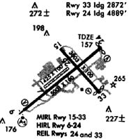
Runways
Runway Summary
| Runways: | 06/24 07/25 15/33 |
| Longest Runway: | 06/24 is 5001 ft (1524 m) long |
| Runways with an Instrument Approach: | 06 |
POU Airport Runway Details
| Runway 06/24 | 5001 ft x 100 ft (1524 m x 30 m) | |
| Runway Length Source: | 3RD PARTY SURVEY as of 12/20/2019 | |
| Surface: | Asphalt - Excellent condition - Saw-cut or plastic grooved | |
| Runway Pavement Class: | 42 /F/D/W/T | |
| Runway Edge Lights: | High Intensity | |
Runway Weight Bearing Capacity (in thousands of pounds) |
||
| Single Wheel Landing Gear: | 50.0 | |
| Dual Wheel Landing Gear: | 60.0 | |
| Dual Tandem Wheel Landing Gear: | 110.0 | |
Runway 06 |
Runway 24 |
|
Elevation: |
146.6 | 154.8 |
Latitude: |
41-37-18.9049N | 41-37-50.1463N |
Longitude: |
073-53-31.2025W | 073-52-40.1896W |
|
Runway True Alignment: |
051 | 231 |
ILS Type: |
ILS | |
Glide Path Angle: |
3.0 degrees | 3.4 degrees |
Traffic Pattern: |
Left | Left |
Runway Markings Type: |
Precision Instrument | Nonprecision Instrument |
Runway Markings Condition: |
Good | Good |
Object at End: |
TREE | TREE |
Object Height: |
18 | 71 |
Object Marked/Lighted?: |
Lighted | |
Distance from End: |
380 | 210 |
Object Centerline Offset: |
300 ft. left of centerline | 400 ft. left of centerline |
Visual Glide Slope Indicators: |
4-Light PAPI On Left Side Of Runway | 4-Light PAPI On Left Side Of Runway |
Approach Light System: |
1,400 Foot Medium Intensity Approach Lighting System With Runway Alignment Indicator Lights | |
REIL: |
Yes | |
Threshold Crossing Height: |
57 | 57 |
Threshold Elevation: |
154.9 | |
Displaced Threshold: |
115 | |
Threshold Latitude: |
41-37-49.4285N | |
Threshold Longitude: |
073-52-41.3622W | |
Declared Distances |
||
Take Off Run Avbl. (TORA): |
5001 | 5001 |
Take Off Distance Avbl. (TODA): |
5001 | 5001 |
Actual Stop Dist. Avbl. (ASDA): |
5001 | 5001 |
Landing Dist. Avbl. (LDA): |
5001 | 4886 |
| Runway 07/25 | 1357 ft x 100 ft (414 m x 30 m) | |
| Runway Length Source: | 3RD PARTY SURVEY as of 12/20/2019 | |
| Surface: | Asphalt - Excellent condition - No special surface treatment | |
Runway 07 |
Runway 25 |
|
Elevation: |
151.7 | 153.4 |
Latitude: |
41-37-29.9201N | 41-37-38.3931N |
Longitude: |
073-53-17.4371W | 073-53-03.5894W |
|
Runway True Alignment: |
051 | 231 |
Glide Path Angle: |
0.0 degrees | 0.0 degrees |
Object at End: |
ANT | |
Object Height: |
24 | |
Distance from End: |
215 | |
Object Centerline Offset: |
300 ft. left of centerline | 400 ft. left of centerline |
| Runway 15/33 | 2743 ft x 100 ft (836 m x 30 m) | |
| Runway Length Source: | 3RD PARTY SURVEY as of 12/20/2019 | |
| Surface: | Asphalt - Excellent condition - No special surface treatment | |
| Runway Pavement Class: | 26 /F/D/W/T | |
| Runway Edge Lights: | Medium Intensity | |
Runway Weight Bearing Capacity (in thousands of pounds) |
||
| Single Wheel Landing Gear: | 35.0 | |
| Dual Wheel Landing Gear: | 45.0 | |
| Dual Tandem Wheel Landing Gear: | 80.0 | |
Runway 15 |
Runway 33 |
|
Elevation: |
155.6 | 163.5 |
Latitude: |
41-37-48.7987N | 41-37-28.4448N |
Longitude: |
073-53-06.5535W | 073-52-42.7014W |
|
Runway True Alignment: |
139 | 319 |
Glide Path Angle: |
0.0 degrees | 3.8 degrees |
Traffic Pattern: |
Left | Left |
Runway Markings Type: |
Basic | Basic |
Runway Markings Condition: |
Good | Good |
Object at End: |
TREES | TREES |
Object Height: |
51 | 37 |
Distance from End: |
900 | 240 |
Object Centerline Offset: |
300 ft. left of centerline | 400 ft. left of centerline |
Visual Glide Slope Indicators: |
4-Box VASI On Left Side Of Runway | |
REIL: |
Yes | |
Threshold Crossing Height: |
64 | |
Declared Distances |
||
Take Off Run Avbl. (TORA): |
2743 | 2743 |
Take Off Distance Avbl. (TODA): |
2743 | 2743 |
Actual Stop Dist. Avbl. (ASDA): |
2743 | 2743 |
Landing Dist. Avbl. (LDA): |
2743 | 2743 |
Services
Airframe Repair: |
Major |
Powerplant Repair: |
Major |
Bottled Oxygen: |
High Pressure / Low Pressure |
Bulk Oxygen: |
None |
Fuel Available: |
100LL, Jet A |
Landing Fees: |
No |
Parking: |
Hangars and tiedowns available |
Maps & Diagrams
POU Sectional
Flight Planning
at skyvector.com
at skyvector.com