Location
Latitude: |
41-07-42.2000N (41.128389) |
Longitude: |
074-20-47.5000W (-74.346528) |
Elevation: |
789.6 feet MSL (241 m MSL) |
Magnetic Variation: |
12.5 W (as of April 2024 from WMM2020 model) |
Time Zone: |
UTC -5.0 (Standard Time) UTC -4.0 (Daylight Savings Time) |
From City: |
01 N.M. E of West Milford, New Jersey |
Found On: |
New York Chart |
FAA Region: |
AEA |
Contacts
Manager: |
Publicly owned: |
| TIM WAGNER 126A AIRPORT RD BOX 1 WEST MILFORD, NJ 07480 973-728-7721 |
N.J. DEPT. TRANSPORTATION 1035 PARKWAY AVE. P.O. BOX 610 TRENTON, NJ 08625 609-530-2900 |
Operations
Airport Status: |
Operational |
Facility Use: |
Public |
Type: |
Airport |
Activation Date: |
06/1960 |
Control tower: |
No |
Attendance (Months/Days/Hours): |
Months/Days/Hours ALL/ALL/0800-1700 |
Boundary ARTCC: |
ZNY (New York) |
Responsible ARTCC: |
ZNY (New York) |
Lighting Schedule: |
SEE RMK |
Segmented Circle Indicator: |
No |
Traffic Pattern Altitude (MSL): |
1790 feet (546 m) |
NOTAMs Facility: |
MIV |
NOTAM-D Service: |
Yes |
International Airport of Entry: |
No |
Customs Landing Rights: |
No |
Military Landing Rights: |
No |
Civil/Military Joint Use: |
No |
Based Aircraft
| Single Engine: | 38 |
| Multi Engine: | 2 |
| GA Helicopters: | 1 |
Annual Operations (as of 03/31/2023)
| Total Operations: | 28160 | |
| GA Local: | 22600 | 80.3% |
| GA Itinerant: | 5560 | 19.7% |
Communications
| CTAF: | 122.900 |
| Approach: | NEW YORK 127.6 127.6 |
| Departure: | NEW YORK 127.6 127.6 |
Fixed Based Operators (FBOs) & Fuel
(Click on a business for detail)
Please help us keep this information up to date. This is a FREE SERVICE just like everything else on Airport Guide! If you see that a business needs to be added, modified, or deleted please fill out our Update Form.
To add, modify, or delete a business click here.
Please help us keep this information up to date. This is a FREE SERVICE just like everything else on Airport Guide! If you see that a business needs to be added, modified, or deleted please fill out our Update Form.
Area Code: 973 |
| Business Name | Frequency | Phone | Fuel Grade |
|---|---|---|---|
| T & R Pegasus
Update FBO info |
Unicom 122.9 | 728-2444 | 100LL |
Flight Service Stations
| Primary | Alternate | |
| FSS on Field: | N | |
| FSS Name (ID): | Millville(MIV) | |
| Frequency: | ||
| Toll Free Phone: | 1-800-WX-BRIEF |
Instrument Procedures / Charts
FAA Terminal Procedures valid from 0901Z 03/21/24 to 0901Z 04/18/24.
There are various types of charts available for an airport. They are listed in the Page Type column. Here is a legend for those types:
APD - Airport Diagram
DP - Departure Procedure Charts
HOT - Hot Spots
IAP - Instrument Approach Procedure Charts
MIN - Minimums
STAR - Standard Terminal Arrival Charts
| Page Type | Page Name | Volume | Action Since Last Cycle |
|---|---|---|---|
| IAP | RNAV (GPS) RWY 06 | NE-2 | |
| IAP | RNAV (GPS) RWY 24 | NE-2 | |
| MIN | TAKEOFF MINIMUMS | NE-2 |
Terminal Procedures are only available for airports in several countries with more being added all the time. If you are looking for a specific country's charts, please send an email to support(at)airportguide.com stating the country name. This will be used to prioritize the implementation.
Navigation Aids (Navaids) near 4N1
| Dist (NM) | ID | Morse Code | Name | Type | Freq | True Hdg | Mag Hdg |
|---|---|---|---|---|---|---|---|
| 9.4 | SAX | . . . . _ _ . . _ | Sparta | VORTAC | 115.70 | 247 | 259 |
| 20.2 | HUO | . . . . . . _ _ _ _ | Huguenot | VOR-DME | 116.10 | 326 | 338 |
| 21.2 | TEB | _ . _ . . . | Teterboro | VOR-DME | 108.40 | 142 | 155 |
| 21.7 | TE | _ . | Torby | NDB | 214 | 153 | 166 |
| 22.1 | SW | . . . . _ _ | Neely | NDB | 335 | 13 | 26 |
| 23.6 | CAT | _ . _ . . _ _ | Chatham | NDB | 254 | 189 | 201 |
| 24.9 | STW | . . . _ . _ _ | Stillwater | VOR-DME | 109.60 | 251 | 263 |
| 26.5 | EWR | . . _ _ . _ . | Maryann | FAN MARKER | 164 | 177 | |
| 27.6 | SKU | . . . _ . _ . . _ | Stanwyck | NDB | 261 | 29 | 42 |
| 27.6 | SKU | . . . _ . _ . . _ | Stanwyck | FAN MARKER | 29 | 42 | |
| 28.3 | EWR | . . _ _ . _ . | Newark | DME | 113.75 | 164 | 177 |
| 29.3 | BWZ | _ . . . . _ _ _ _ . . | Broadway | VOR-DME | 114.20 | 227 | 239 |
| 29.9 | LGA | . _ . . _ _ . . _ | La Guardia | VOR-DME | 113.10 | 133 | 146 |
| 31.8 | PO | . _ _ . _ _ _ | Meier | NDB | 403 | 32 | 45 |
| 35.7 | CMK | _ . _ . _ _ _ . _ | Carmel | VOR-DME | 116.60 | 74 | 87 |
| 37.1 | CRI | _ . _ . . _ . . . | Canarsie | VOR-DME | 112.30 | 146 | 159 |
| 37.3 | SBJ | . . . _ . . . . _ _ _ | Solberg | VOR-DME | 112.90 | 208 | 220 |
| 39.6 | JFK | . _ _ _ . . _ . _ . _ | Kennedy | VOR-DME | 115.90 | 138 | 151 |
| 39.7 | OGY | _ _ _ _ _ . _ . _ _ | Bridge | NDB | 414 | 147 | 160 |
| 39.9 | IGN | . . _ _ . _ . | Kingston | VOR-DME | 117.60 | 36 | 49 |
Nearby Airports with Fuel
Notices to Airmen (NOTAMS)
Remarks
| A110-1 | RY 06/24 STEEP ROCK LEDGES LCTD JUST BYD BOTH RY ENDS. |
| A110-2 | ARPT SUBJECT TO GUSTING WIND & FREQUENT CROSSWINDS. |
| A110-3 | SOME RWY AND TWY LGTS TALLER THAN STANDARD. |
| A110-5 | DEER AND BIRDS ON AND INVOF ARPT. |
| A110-6 | FOR CD CTC NEW YORK APCH AT 800-645-3206. |
| A110-7 | DROP ZONE LCTD SE SIDE OF RWY. |
| A52-06 | TREES BELOW RWY END, CLIFF. |
| A81-APT | ACTVT MIRL RWY 06/24 - CTAF, 5 CLICKS. PAPI RWY 24 OPR CONSLY. |
| E100 | AUTOMATED UNICOM; 3 CLICKS TO ACTVT. |
| E111 | RECOMMENDED THAT WIRES RWY 6 APCH BE MKD WITH PLASTIC BALLS OR PUT UNDERGND (WIRES NOW MKD & LGTS MOUNTED ON POLES). |
Runways
Runway Summary
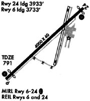
| Runways: | 06/24 |
| Longest Runway: | 06/24 is 3471 ft (1058 m) long |
| Runways with an Instrument Approach: |
4N1 Airport Runway Details
| Runway 06/24 | 3471 ft x 60 ft (1058 m x 18 m) | |
| Runway Length Source: | 3RD PARTY SURVEY as of 06/23/2016 | |
| Surface: | Asphalt - Excellent condition - No special surface treatment | |
| Runway Edge Lights: | Medium Intensity | |
Runway 06 |
Runway 24 |
|
Elevation: |
789.3 | 789.4 |
Latitude: |
41-07-30.6575N | 41-07-53.6813N |
Longitude: |
074-21-04.3215W | 074-20-30.7002W |
|
Runway True Alignment: |
048 | 228 |
Glide Path Angle: |
0.0 degrees | 3.5 degrees |
Traffic Pattern: |
Right | Left |
Runway Markings Type: |
Nonprecision Instrument | Nonprecision Instrument |
Runway Markings Condition: |
Good | Good |
Object at End: |
TREES | TREE |
Object Height: |
192 | 23 |
Distance from End: |
1988 | 680 |
Object Centerline Offset: |
170 ft. right of centerline | 132 ft. left of centerline |
Visual Glide Slope Indicators: |
2-Light PAPI On Left Side Of Runway | |
REIL: |
No | No |
Threshold Crossing Height: |
44 |
Services
Airframe Repair: |
Major |
Powerplant Repair: |
Major |
Bottled Oxygen: |
High Pressure / Low Pressure |
Bulk Oxygen: |
High Pressure / Low Pressure |
Fuel Available: |
100LL, Jet A |
Landing Fees: |
No |
Parking: |
Hangars and tiedowns available |
Maps & Diagrams
4N1 Sectional
Flight Planning
at skyvector.com
at skyvector.com