Location
Latitude: |
41-30-31.3730N (41.508715) |
Longitude: |
072-49-46.1220W (-72.829478) |
Elevation: |
103.0 feet MSL (31 m MSL) |
Magnetic Variation: |
13.3 W (as of April 2024 from WMM2020 model) |
Time Zone: |
UTC -5.0 (Standard Time) UTC -4.0 (Daylight Savings Time) |
From City: |
03 N.M. SW of Meriden, Connecticut |
Found On: |
New York Chart |
FAA Region: |
ANE |
Contacts
Manager: |
Publicly owned: |
| CONSTANCE CASTILLO 213 EVANSVILLE AVENUE MERIDEN, CT 06451 203-630-2878 |
CITY OF MERIDEN CITY MANAGER, CITY HALL, 142 E MAIN ST MERIDEN, CT 06450 (203) 630-4115 |
Operations
Airport Status: |
Operational |
Facility Use: |
Public |
Type: |
Airport |
Activation Date: |
04/1940 |
Control tower: |
No |
Attendance (Months/Days/Hours): |
Months/Days/Hours ALL/MON-SUN/0900-1700 |
Boundary ARTCC: |
ZBW (Boston) |
Responsible ARTCC: |
ZBW (Boston) |
Lighting Schedule: |
SEE RMK |
Segmented Circle Indicator: |
Yes |
Traffic Pattern Altitude (MSL): |
1103 feet (336 m) |
NOTAMs Facility: |
MMK |
NOTAM-D Service: |
Yes |
International Airport of Entry: |
No |
Customs Landing Rights: |
No |
Military Landing Rights: |
No |
Civil/Military Joint Use: |
No |
Based Aircraft
| Single Engine: | 45 |
Annual Operations (as of 08/22/2022)
| Total Operations: | 53823 | |
| Air Taxi: | 1760 | 3.3% |
| GA Local: | 28494 | 52.9% |
| GA Itinerant: | 23486 | 43.6% |
| Military Aircraft: | 83 | 0.2% |
Communications
| CTAF: | 123.050 |
| Unicom: | 123.050 |
| Clearance Del.: | 120.65 120.65 120.65 |
| Approach: | BRADLEY |
| Departure: | BRADLEY |
| ASOS: | 134.925 (203-639-9405) |
Fixed Based Operators (FBOs) & Fuel
(Click on a business for detail)
Please help us keep this information up to date. This is a FREE SERVICE just like everything else on Airport Guide! If you see that a business needs to be added, modified, or deleted please fill out our Update Form.
To add, modify, or delete a business click here.
Please help us keep this information up to date. This is a FREE SERVICE just like everything else on Airport Guide! If you see that a business needs to be added, modified, or deleted please fill out our Update Form.
Area Code: 203 |
| Business Name | Frequency | Phone | Fuel Grade |
|---|---|---|---|
| Meriden Aviation Services
Update FBO info |
123.05 | 238-4400 | 100LL |

|
 Avfuel |
100LL - 2.61 USD per gallon on 9/3/01 |
Pumps requiring line service no discounts |
Flight Service Stations
| Primary | Alternate | |
| FSS on Field: | N | |
| FSS Name (ID): | Bridgeport(BDR) | |
| Frequency: | ||
| Toll Free Phone: | 1-800-WX-BRIEF |
Instrument Procedures / Charts
FAA Terminal Procedures valid from 0901Z 03/21/24 to 0901Z 04/18/24.
There are various types of charts available for an airport. They are listed in the Page Type column. Here is a legend for those types:
APD - Airport Diagram
DP - Departure Procedure Charts
HOT - Hot Spots
IAP - Instrument Approach Procedure Charts
MIN - Minimums
STAR - Standard Terminal Arrival Charts
| Page Type | Page Name | Volume | Action Since Last Cycle |
|---|---|---|---|
| IAP | RNAV (GPS) RWY 36 | NE-1 | |
| IAP | VOR RWY 36 | NE-1 | |
| MIN | ALTERNATE MINIMUMS | NE-1 | |
| MIN | TAKEOFF MINIMUMS | NE-1 |
Terminal Procedures are only available for airports in several countries with more being added all the time. If you are looking for a specific country's charts, please send an email to support(at)airportguide.com stating the country name. This will be used to prioritize the implementation.
Navigation Aids (Navaids) near KMMK
| Dist (NM) | ID | Morse Code | Name | Type | Freq | True Hdg | Mag Hdg |
|---|---|---|---|---|---|---|---|
| 13.2 | MAD | _ _ . _ _ . . | Madison | VOR-DME | 110.40 | 152 | 165 |
| 14.8 | JWE | . _ _ _ . _ _ . | Clera | NDB | 362 | 239 | 252 |
| 14.9 | HFD | . . . . . . _ . _ . . | Hartford | VOR-DME | 114.90 | 57 | 70 |
| 15.0 | HVN | . . . . . . . _ _ . | New Haven | DME | 109.8 | 189 | 202 |
| 15.7 | HFD | . . . . . . _ . _ . . | Hartford | VOT | 108.20 | 30 | 43 |
| 24.7 | BDR | _ . . . _ . . . _ . | Bridgeport | VOT | 109.25 | 212 | 225 |
| 24.8 | BDR | _ . . . _ . . . _ . | Bridgeport | VOR-DME | 108.80 | 212 | 225 |
| 26.2 | BDL | _ . . . _ . . . _ . . | Bradley | VOT | 111.40 | 14 | 27 |
| 26.7 | BDL | _ . . . _ . . . _ . . | Bradley | VORTAC | 109.00 | 13 | 26 |
| 34.5 | OP | _ _ _ . _ _ . | Old Field Point Light | NDB | 316 | 202 | 215 |
| 34.8 | CCC | _ . _ . _ . _ . _ . _ . | Calverton | VOR-DME | 114.55 | 177 | 190 |
| 36.5 | CMK | _ . _ . _ _ _ . _ | Carmel | VOR-DME | 116.60 | 248 | 261 |
| 36.6 | GON | _ _ . _ _ _ _ . | Groton | VOR-DME | 110.85 | 106 | 119 |
| 36.7 | GON | _ _ . _ _ _ _ . | Groton | VOT | 110.25 | 107 | 120 |
| 37.4 | ORW | _ _ _ . _ . . _ _ | Norwich | VOR-DME | 110.00 | 85 | 98 |
| 38.0 | PWL | . _ _ . . _ _ . _ . . | Pawling | VOR-DME | 114.30 | 294 | 307 |
| 38.3 | FO | . . _ . _ _ _ | Squir | NDB | 400 | 161 | 174 |
| 39.5 | BAF | _ . . . . _ . . _ . | Barnes | VORTAC | 113.00 | 7 | 20 |
| 41.2 | FOK | . . _ . _ _ _ _ . _ | Suffolk Co | TACAN | 111.00 | 167 | 180 |
| 42.3 | HTO | . . . . _ _ _ _ | Hampton | VORTAC | 113.60 | 146 | 159 |
Nearby Airports with Fuel
Notices to Airmen (NOTAMS)
Remarks
| A110*G | THIS AIRPORT HAS BEEN SURVEYED BY THE NATIONAL GEODETIC SURVEY. |
| A110-1 | RWY 36 NO TGLS. |
| A110-10 | CRANES 150 FT AGL, 0.25 MI NW AER 18, LGTD. OPER INTMT DALGT HRS. |
| A110-2 | PPR FOR JET ACFT. |
| A110-6 | CALM WIND RWY 18. |
| A110-7 | STD LEFT TFC, BOTH RWYS. |
| A110-8 | FOR CD CTC YANKEE APCH AT 860-386-3597. |
| A110-9 | CTN DEER, COYOTES & BIRDS ON & INVOF ARPT. |
| A58-18 | 5 FT BRUSH, 0 FT DSTC, 161 FT R, 8 FT BR, 190 FT DSTC. |
| A70-FUEL-10 | 0LL SELF SVC FUEL. |
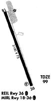
| A81-APT | ACTVT REIL RWY 36; MIRL RWY 18/36 - CTAF. |
Runways
Runway Summary
| Runways: | 18/36 |
| Longest Runway: | 18/36 is 3100 ft (945 m) long |
| Runways with an Instrument Approach: |
KMMK Airport Runway Details
| Runway 18/36 | 3100 ft x 75 ft (945 m x 23 m) | |
| Surface: | Asphalt - Good condition - No special surface treatment | |
| Runway Edge Lights: | Medium Intensity | |
Runway Weight Bearing Capacity (in thousands of pounds) |
||
| Single Wheel Landing Gear: | 30.0 | |
Runway 18 |
Runway 36 |
|
Elevation: |
103.0 | 98.6 |
Latitude: |
41-30-45.9110N | 41-30-16.8360N |
Longitude: |
072-49-52.5260W | 072-49-39.7190W |
|
Runway True Alignment: |
162 | 342 |
Glide Path Angle: |
0.0 degrees | 3.5 degrees |
Traffic Pattern: |
Left | Left |
Runway Markings Type: |
Nonprecision Instrument | Nonprecision Instrument |
Runway Markings Condition: |
Good | Good |
Object at End: |
TREE | TREE |
Object Height: |
60 | 75 |
Distance from End: |
700 | 975 |
Object Centerline Offset: |
250 ft. left of centerline | 305 ft. right of centerline |
Visual Glide Slope Indicators: |
4-Light PAPI On Left Side Of Runway | |
REIL: |
Yes | |
Threshold Crossing Height: |
38 |
Services
Airframe Repair: |
Major |
Powerplant Repair: |
Major |
Fuel Available: |
100LL |
Landing Fees: |
No |
Parking: |
Tiedowns available |
Maps & Diagrams
KMMK Sectional
Flight Planning
at skyvector.com
at skyvector.com