Location
Latitude: |
36-10-35.0000N (36.176389) |
Longitude: |
094-07-09.3000W (-94.11925) |
Elevation: |
1352.5 feet MSL (412 m MSL) |
Magnetic Variation: |
1 E (as of April 2024 from WMM2020 model) |
Time Zone: |
UTC -6.0 (Standard Time) UTC -5.0 (Daylight Savings Time) |
From City: |
01 N.M. SE of Springdale, Arkansas |
Found On: |
Kansas City Chart |
FAA Region: |
ASW |
Contacts
Manager: |
Publicly owned: |
| JAMES SMITH 802 AIRPORT AVENUE SPRINGDALE, AR 72764 479-750-8135 |
CITY OF SPRINGDALE CITY HALL, 201 SPRING ST SPRINGDALE, AR 72764 479-750-8114 |
Operations
Airport Status: |
Operational |
Facility Use: |
Public |
Type: |
Airport |
Activation Date: |
04/1944 |
Control tower: |
Yes |
Attendance (Months/Days/Hours): |
Months/Days/Hours ALL/ALL/0600-2100 |
Boundary ARTCC: |
ZME (Memphis) |
Responsible ARTCC: |
ZME (Memphis) |
Lighting Schedule: |
SEE RMK |
Segmented Circle Indicator: |
Yes |
Traffic Pattern Altitude (MSL): |
2352 feet (717 m) |
NOTAMs Facility: |
ASG |
NOTAM-D Service: |
Yes |
International Airport of Entry: |
No |
Customs Landing Rights: |
No |
Military Landing Rights: |
Yes |
Civil/Military Joint Use: |
No |
Based Aircraft
| Single Engine: | 74 |
| Multi Engine: | 10 |
| Jet Engine: | 3 |
| GA Helicopters: | 3 |
Annual Operations (as of 04/30/2019)
| Total Operations: | 62450 | |
| Air Taxi: | 4400 | 7.0% |
| GA Local: | 28000 | 44.8% |
| GA Itinerant: | 30000 | 48.0% |
| Military Aircraft: | 50 | 0.1% |
Communications
| CTAF: | 118.200 |
| Unicom: | 122.950 |
| Tower: | SPRINGDALE 118.2 Hrs: 0600-2100 |
| Ground: | 121.6 |
| Approach: | RAZORBACK 126.6 126.6 MEMPHIS ARTCC |
| Departure: | RAZORBACK 126.6 126.6 MEMPHIS ARTCC |
| AWOS-3: | 124.675 (479-750-2967) |
- APCH/DEP SVC PRVDD BY MEMPHIS ARTCC ON FREQS 126.1/269.0 (FAYETTEVILLE RCAG) WHEN RAZORBACK APCH CTL CLSD.
Fixed Based Operators (FBOs) & Fuel
(Click on a business for detail)
Please help us keep this information up to date. This is a FREE SERVICE just like everything else on Airport Guide! If you see that a business needs to be added, modified, or deleted please fill out our Update Form.
To add, modify, or delete a business click here.
Please help us keep this information up to date. This is a FREE SERVICE just like everything else on Airport Guide! If you see that a business needs to be added, modified, or deleted please fill out our Update Form.
Area Code: 501 |
| Business Name | Frequency | Phone | Fuel Grade |
|---|---|---|---|
| Fly #1
Update FBO info |
Unicom 122.95 | 751-2646, -5050 | 100LL, Jet A |
| Springdale Air Service
Update FBO info |
Unicom 122.95 | 751-4462 | 100LL, Jet A |
Flight Service Stations
| Primary | Alternate | |
| FSS on Field: | N | |
| FSS Name (ID): | Jonesboro(JBR) | |
| Frequency: | ||
| Toll Free Phone: | 1-800-WX-BRIEF |
Instrument Procedures / Charts
FAA Terminal Procedures valid from 0901Z 03/21/24 to 0901Z 04/18/24.
There are various types of charts available for an airport. They are listed in the Page Type column. Here is a legend for those types:
APD - Airport Diagram
DP - Departure Procedure Charts
HOT - Hot Spots
IAP - Instrument Approach Procedure Charts
MIN - Minimums
STAR - Standard Terminal Arrival Charts
| Page Type | Page Name | Volume | Action Since Last Cycle |
|---|---|---|---|
| APD | AIRPORT DIAGRAM | SC-1 | |
| DP | SPRING FIVE | SC-1 | |
| IAP | ILS OR LOC RWY 18 | SC-1 | |
| IAP | RNAV (GPS) RWY 18 | SC-1 | |
| IAP | RNAV (GPS) RWY 36 | SC-1 | |
| MIN | ALTERNATE MINIMUMS | SC-1 | |
| MIN | TAKEOFF MINIMUMS | SC-1 |
Terminal Procedures are only available for airports in several countries with more being added all the time. If you are looking for a specific country's charts, please send an email to support(at)airportguide.com stating the country name. This will be used to prioritize the implementation.
Navigation Aids (Navaids) near SPZ
| Dist (NM) | ID | Morse Code | Name | Type | Freq | True Hdg | Mag Hdg |
|---|---|---|---|---|---|---|---|
| 4.2 | RZC | . _ . _ _ . . _ . _ . | Razorback | VORTAC | 116.40 | 358 | 357 |
| 8.9 | DAK | _ . . . _ _ . _ | Drake | DME | 115.25 | 205 | 204 |
| 17.3 | RO | . _ . _ _ _ | Rogrs | NDB | 263 | 7 | 6 |
| 17.9 | SLG | . . . . _ . . _ _ . | Siloam Springs | NDB | 284 | 272 | 271 |
| 42.8 | EOS | . _ _ _ . . . | Neosho | DME | 117.3 | 339 | 338 |
| 44.7 | HRO | . . . . . _ . _ _ _ | Harrison | VOR-DME | 112.50 | 78 | 77 |
| 45.6 | TQH | _ _ _ . _ . . . . | Tahlequah | NDB | 215 | 251 | 250 |
| 46.5 | HR | . . . . . _ . | Bakky | NDB | 395 | 88 | 87 |
| 47.9 | FSM | . . _ . . . . _ _ | Fort Smith | VORTAC | 110.40 | 188 | 187 |
| 49.6 | FS | . . _ . . . . | Wizer | NDB | 223 | 185 | 184 |
| 54.1 | GK | _ _ . _ . _ | Jembo | NDB | 311 | 198 | 197 |
| 54.3 | CZE | _ . _ . _ _ . . . | Clarksville | NDB | 201 | 141 | 140 |
| 57.1 | IQS | . . _ _ . _ . . . | Sallisaw | NDB | 520 | 215 | 214 |
| 65.1 | JL | . _ _ _ . _ . . | Lunns | NDB | 344 | 341 | 340 |
| 74.4 | RUE | . _ . . . _ . | Russellville | NDB | 379 | 137 | 136 |
| 78.5 | DGD | _ . . _ _ . _ . . | Dogwood | VORTAC | 109.40 | 49 | 48 |
| 78.7 | OSW | _ _ _ . . . . _ _ | Oswego | DME | 117.6 | 318 | 317 |
| 79.3 | LLU | . _ . . . _ . . . . _ | Spring River | NDB | 356 | 353 | 352 |
| 80.2 | SGF | . . . _ _ . . . _ . | Springfield | VORTAC | 116.90 | 27 | 26 |
| 80.7 | FLP | . . _ . . _ . . . _ _ . | Flippin | DME | 116.05 | 84 | 84 |
Nearby Airports with Fuel
Notices to Airmen (NOTAMS)
Remarks
| A110-1 | FOR CD WHEN UNA VIA FREQ CTC RAZORBACK APCH 479-649-2416, WHEN APCH CLSD CTC MEMPHIS ARTCC AT 901-368-8453/8449. |
| A17 | FOR SVC AFT HRS CALL 479-751-4462. |
| A24 | ALL ACFT LEFT OVERNIGHT WILL BE CHARGED A RAMP FEE UNLESS FUEL HAS BEEN PURCHASED. |
| A57-18 | APCH RATIO 50:1 FM DSPLCD THR. |
| A70-FUEL-10 | 0LL 100LL AVBL 24 HRS SELF SERVE WITH CREDIT CARD. |
| A81-APT | ACTVT HIRL RWY 18/36 - CTAF. WHEN ATCT CLSD ACTVT MALSF RWY 18 - CTAF. ACTVT REIL RWY 18 AND 36 - 122.8. |
Runways
Runway Summary
| Runways: | 18/36 |
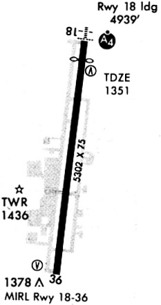
| Longest Runway: | 18/36 is 5302 ft (1616 m) long |
| Runways with an Instrument Approach: | 18 |
SPZ Airport Runway Details
| Runway 18/36 | 5302 ft x 76 ft (1616 m x 23 m) | |
| Runway Length Source: | 3RD PARTY SURVEY as of 07/23/2010 | |
| Surface: | Asphalt - Excellent condition - No special surface treatment | |
| Runway Edge Lights: | High Intensity | |
Runway Weight Bearing Capacity (in thousands of pounds) |
||
| Single Wheel Landing Gear: | 35.0 | |
| Dual Wheel Landing Gear: | 50.0 | |
| Dual Tandem Wheel Landing Gear: | 90.0 | |
Runway 18 |
Runway 36 |
|
Elevation: |
1339.2 | 1352.4 |
Latitude: |
36-11-01.0541N | 36-10-09.0276N |
Longitude: |
094-07-05.2988W | 094-07-13.2843W |
|
Runway True Alignment: |
187 | 007 |
ILS Type: |
ILS | |
Glide Path Angle: |
3.0 degrees | 3.0 degrees |
Traffic Pattern: |
Left | Left |
Runway Markings Type: |
Precision Instrument | Precision Instrument |
Runway Markings Condition: |
Good | Good |
Object at End: |
TREES | |
Object Height: |
40 | |
Distance from End: |
1750 | |
Object Centerline Offset: |
400 ft. left of centerline | |
Visual Glide Slope Indicators: |
4-Light PAPI On Left Side Of Runway | 4-Light PAPI On Right Side Of Runway |
Approach Light System: |
1,400 Foot Medium Intensity Approach Lighting System With Sequenced Flashers | |
REIL: |
Yes | Yes |
Threshold Crossing Height: |
43 | 40 |
Threshold Elevation: |
1339.2 | |
Displaced Threshold: |
363 | |
Threshold Latitude: |
36-10-57.4929N | |
Threshold Longitude: |
094-07-05.8506W |
Services
Airframe Repair: |
Major |
Powerplant Repair: |
Major |
Bottled Oxygen: |
None |
Bulk Oxygen: |
None |
Fuel Available: |
100LL, Jet A |
Landing Fees: |
No |
Parking: |
Hangars and tiedowns available |
Maps & Diagrams
SPZ Sectional
Flight Planning
at skyvector.com
at skyvector.com