Location
Latitude: |
36-00-18.3000N (36.005083) |
Longitude: |
094-10-12.2000W (-94.170056) |
Elevation: |
1252.0 feet MSL (382 m MSL) |
Magnetic Variation: |
1 E (as of April 2024 from WMM2020 model) |
Time Zone: |
UTC -6.0 (Standard Time) UTC -5.0 (Daylight Savings Time) |
From City: |
03 N.M. S of Fayetteville, Arkansas |
Found On: |
Kansas City Chart |
FAA Region: |
ASW |
Contacts
Manager: |
Publicly owned: |
| JARED RABREN 4500 S SCHOOL SUITE F FAYETTEVILLE, AR 72701 (479) 718-7644 |
CITY OF FAYETTEVILLE 113 MOUNTAIN ST FAYETTEVILLE, AR 72701 479-575-8330 |
Operations
Airport Status: |
Operational |
Facility Use: |
Public |
Type: |
Airport |
Activation Date: |
04/1940 |
Control tower: |
Yes |
Attendance (Months/Days/Hours): |
Months/Days/Hours ALL/MON-FRI/0600-2200 |
Boundary ARTCC: |
ZME (Memphis) |
Responsible ARTCC: |
ZME (Memphis) |
Lighting Schedule: |
SEE RMK |
Segmented Circle Indicator: |
No |
Traffic Pattern Altitude (MSL): |
2252 feet (686 m) |
NOTAMs Facility: |
FYV |
NOTAM-D Service: |
Yes |
International Airport of Entry: |
No |
Customs Landing Rights: |
No |
Military Landing Rights: |
Yes |
Civil/Military Joint Use: |
No |
Aircraft Rescue and Firefighting: |
Class IV ARFF Index: A Air Carrier Service: Not Scheduled Certification Date: 11/2005 |
Based Aircraft
| Single Engine: | 88 |
| Multi Engine: | 6 |
| Jet Engine: | 17 |
| GA Helicopters: | 2 |
Annual Operations (as of 06/30/2023)
| Total Operations: | 26768 | |
| Commercial: | 92 | 0.3% |
| Air Taxi: | 1522 | 5.7% |
| GA Local: | 8487 | 31.7% |
| GA Itinerant: | 15877 | 59.3% |
| Military Aircraft: | 790 | 3.0% |
Communications
| CTAF: | 128.000 |
| Unicom: | 122.950 |
| Tower: | DRAKE 128.0 371.9 Hrs: 0600-2200 |
| Ground: | 121.8 |
| Approach: | RAZORBACK 121.0 121.0 MEMPHIS ARTCC |
| Departure: | RAZORBACK 121.0 121.0 MEMPHIS ARTCC |
| ATIS: | 119.575 Hrs: 24 |
| ASOS: | 119.575 (479-442-5237) |
- APCH/DEP SVC PRVDD BY MEMPHIS ARTCC ON FREQS 126.1/269.0 (FAYETTEVILLE RCAG) WHEN RAZORBACK APCH CTL CLSD.
Fixed Based Operators (FBOs) & Fuel
(Click on a business for detail)
Please help us keep this information up to date. This is a FREE SERVICE just like everything else on Airport Guide! If you see that a business needs to be added, modified, or deleted please fill out our Update Form.
To add, modify, or delete a business click here.
Please help us keep this information up to date. This is a FREE SERVICE just like everything else on Airport Guide! If you see that a business needs to be added, modified, or deleted please fill out our Update Form.
Area Code: 501 |
| Business Name | Frequency | Phone | Fuel Grade |
|---|---|---|---|
| Drake Aviation Academy
Update FBO info |
582-2359, 888-584-2359 | ||
| Fayetteville Air Service
Update FBO info |
Unicom 122.95 | 443-4343 | 100LL, Jet A |
Flight Service Stations
| Primary | Alternate | |
| FSS on Field: | N | |
| FSS Name (ID): | Jonesboro(JBR) | |
| Frequency: | ||
| Toll Free Phone: | 1-800-WX-BRIEF |
Instrument Procedures / Charts
FAA Terminal Procedures valid from 0901Z 03/21/24 to 0901Z 04/18/24.
There are various types of charts available for an airport. They are listed in the Page Type column. Here is a legend for those types:
APD - Airport Diagram
DP - Departure Procedure Charts
HOT - Hot Spots
IAP - Instrument Approach Procedure Charts
MIN - Minimums
STAR - Standard Terminal Arrival Charts
| Page Type | Page Name | Volume | Action Since Last Cycle |
|---|---|---|---|
| APD | AIRPORT DIAGRAM | SC-1 | |
| DP | RAZORBACK THREE | SC-1 | |
| IAP | LDA RWY 34 | SC-1 | |
| IAP | LOC RWY 16 | SC-1 | |
| IAP | RNAV (GPS) RWY 16 | SC-1 | |
| IAP | RNAV (GPS) RWY 34 | SC-1 | |
| MIN | ALTERNATE MINIMUMS | SC-1 | |
| MIN | TAKEOFF MINIMUMS | SC-1 |
Terminal Procedures are only available for airports in several countries with more being added all the time. If you are looking for a specific country's charts, please send an email to support(at)airportguide.com stating the country name. This will be used to prioritize the implementation.
Navigation Aids (Navaids) near FYV
| Dist (NM) | ID | Morse Code | Name | Type | Freq | True Hdg | Mag Hdg |
|---|---|---|---|---|---|---|---|
| 2.6 | DAK | _ . . . _ _ . _ | Drake | DME | 115.25 | 329 | 328 |
| 14.7 | RZC | . _ . _ _ . . _ . _ . | Razorback | VORTAC | 116.40 | 9 | 8 |
| 19.0 | SLG | . . . . _ . . _ _ . | Siloam Springs | NDB | 284 | 305 | 304 |
| 27.8 | RO | . _ . _ _ _ | Rogrs | NDB | 263 | 10 | 9 |
| 37.3 | FSM | . . _ . . . . _ _ | Fort Smith | VORTAC | 110.40 | 187 | 186 |
| 39.1 | FS | . . _ . . . . | Wizer | NDB | 223 | 183 | 182 |
| 40.9 | TQH | _ _ _ . _ . . . . | Tahlequah | NDB | 215 | 263 | 262 |
| 43.5 | GK | _ _ . _ . _ | Jembo | NDB | 311 | 199 | 198 |
| 47.4 | IQS | . . _ _ . _ . . . | Sallisaw | NDB | 520 | 220 | 219 |
| 48.5 | CZE | _ . _ . _ _ . . . | Clarksville | NDB | 201 | 131 | 130 |
| 50.0 | HRO | . . . . . _ . _ _ _ | Harrison | VOR-DME | 112.50 | 67 | 66 |
| 50.2 | HR | . . . . . _ . | Bakky | NDB | 395 | 76 | 75 |
| 51.9 | EOS | . _ _ _ . . . | Neosho | DME | 117.3 | 345 | 344 |
| 69.0 | RUE | . _ . . . _ . | Russellville | NDB | 379 | 130 | 129 |
| 74.3 | JL | . _ _ _ . _ . . | Lunns | NDB | 344 | 345 | 344 |
| 79.3 | TUL | _ . . _ . _ . . | Tulsa | VORTAC | 114.40 | 278 | 276 |
| 80.7 | MPJ | _ _ . _ _ . . _ _ _ | Morrilton | NDB | 410 | 130 | 129 |
| 82.3 | PGO | . _ _ . _ _ . _ _ _ | Rich Mountain | VORTAC | 113.50 | 195 | 194 |
| 83.6 | TU | _ . . _ | Oillr | NDB | 338 | 274 | 272 |
| 83.9 | TUL | _ . . _ . _ . . | Tulsa Intl | VOT | 109.00 | 278 | 276 |
Nearby Airports with Fuel
Notices to Airmen (NOTAMS)
Remarks
| A110-1 | DEER ON & INVOF ARPT. |
| A110-2 | FOR CD CTC MEMPHIS ARTCC AT 901-368-8453/8449. |
| A14 | DIRECTOR, AVIATION. |
| A26 | 24 HR PPR FOR ACR OPNS WITH MORE THAN 30 PSGR SEATS CALL AMGR 479-718-7642 & FAX FBO 479-718-7646. |
| A70-FUEL-10 | 0LL FOR FUEL AFTER HRS CALL 479-443-4343; FEE CHARGED. SELF SERVICE AVBL 24 HRS. |
| A81-APT | WHEN ATCT CLSD MIRL RWY 16/34 PRESET MED INTST. ACTVT ODALS RWY 16 & 34; PAPI RWY 34 - CTAF. |
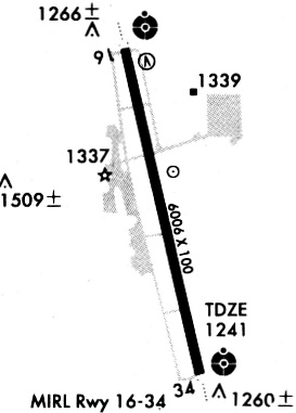
Runways
Runway Summary
| Runways: | 16/34 |
| Longest Runway: | 16/34 is 6005 ft (1830 m) long |
| Runways with an Instrument Approach: | 16, 34 |
FYV Airport Runway Details
| Runway 16/34 | 6005 ft x 100 ft (1830 m x 30 m) | |
| Runway Length Source: | 3RD PARTY SURVEY as of 09/21/2007 | |
| Surface: | Asphalt - Good condition - Saw-cut or plastic grooved | |
| Runway Edge Lights: | Medium Intensity | |
Runway Weight Bearing Capacity (in thousands of pounds) |
||
| Single Wheel Landing Gear: | 90.0 | |
| Dual Wheel Landing Gear: | 150.0 | |
| Dual Tandem Wheel Landing Gear: | 175.0 | |
Runway 16 |
Runway 34 |
|
Elevation: |
1250.8 | 1237.9 |
Latitude: |
36-00-47.4849N | 35-59-49.2058N |
Longitude: |
094-10-19.2210W | 094-10-05.2158W |
|
Runway True Alignment: |
169 | 349 |
ILS Type: |
LOC/DME | LDA/DME |
Glide Path Angle: |
3.0 degrees | 3.5 degrees |
Traffic Pattern: |
Left | Left |
Runway Markings Type: |
Precision Instrument | Precision Instrument |
Runway Markings Condition: |
Good | Good |
Object at End: |
TREE | |
Object Height: |
263 | |
Distance from End: |
5585 | |
Object Centerline Offset: |
958 ft. right of centerline | |
Visual Glide Slope Indicators: |
4-Light PAPI On Left Side Of Runway | 4-Light PAPI On Left Side Of Runway |
Approach Light System: |
Omnidirectional Approach Lighting System | Omnidirectional Approach Lighting System |
Threshold Crossing Height: |
50 | 58 |
Declared Distances |
||
Take Off Run Avbl. (TORA): |
6005 | 6005 |
Take Off Distance Avbl. (TODA): |
6005 | 6005 |
Actual Stop Dist. Avbl. (ASDA): |
6005 | 6005 |
Landing Dist. Avbl. (LDA): |
6005 | 6005 |
Services
Airframe Repair: |
Minor |
Powerplant Repair: |
Minor |
Bottled Oxygen: |
None |
Bulk Oxygen: |
None |
Fuel Available: |
100LL, Jet A |
Landing Fees: |
No |
Parking: |
Hangars and tiedowns available |
Maps & Diagrams
FYV Sectional
Flight Planning
at skyvector.com
at skyvector.com