Location
Latitude: |
35-30-38.5050N (35.510696) |
Longitude: |
093-50-21.5070W (-93.839308) |
Elevation: |
648.0 feet MSL (198 m MSL) |
Magnetic Variation: |
0.8 E (as of April 2024 from WMM2020 model) |
Time Zone: |
UTC -6.0 (Standard Time) UTC -5.0 (Daylight Savings Time) |
From City: |
02 N.M. NW of Ozark, Arkansas |
Found On: |
Memphis Chart |
FAA Region: |
ASW |
Contacts
Manager: |
Publicly owned: |
| J. C. SMITH P.O. BOX 262 OZARK, AR 72949 479-667-7618 |
CITY OF OZARK-FRANKLIN CO PO BOX 196 OZARK, AR 72949 479-667-4726 |
Operations
Airport Status: |
Operational |
Facility Use: |
Public |
Type: |
Airport |
Activation Date: |
04/1940 |
Control tower: |
No |
Attendance (Months/Days/Hours): |
Months/Days/Hours UNATTNDD |
Boundary ARTCC: |
ZME (Memphis) |
Responsible ARTCC: |
ZME (Memphis) |
Lighting Schedule: |
SEE RMK |
Segmented Circle Indicator: |
Yes |
Traffic Pattern Altitude (MSL): |
1648 feet (502 m) |
NOTAMs Facility: |
JBR |
NOTAM-D Service: |
Yes |
International Airport of Entry: |
No |
Customs Landing Rights: |
No |
Military Landing Rights: |
Yes |
Civil/Military Joint Use: |
No |
Based Aircraft
| Single Engine: | 9 |
| Multi Engine: | 2 |
| GA Helicopters: | 1 |
Annual Operations (as of 08/31/2021)
| Total Operations: | 6550 | |
| GA Local: | 4000 | 61.1% |
| GA Itinerant: | 2500 | 38.2% |
| Military Aircraft: | 50 | 0.8% |
Communications
| CTAF: | 122.800 |
| Unicom: | 122.800 |
| Approach: | RAZORBACK 120.9 120.9 MEMPHIS ARTCC |
| Departure: | RAZORBACK 120.9 120.9 MEMPHIS ARTCC |
- APCH/DEP SVC PRVDD BY MEMPHIS ARTCC ON FREQS 128.475/377.15 (RUSSELLVILLE RCAG) WHEN RAZORBACK APCH CTL CLSD.
Fixed Based Operators (FBOs) & Fuel
(Click on a business for detail)
Please help us keep this information up to date. This is a FREE SERVICE just like everything else on Airport Guide! If you see that a business needs to be added, modified, or deleted please fill out our Update Form.
To add, modify, or delete a business click here.
Please help us keep this information up to date. This is a FREE SERVICE just like everything else on Airport Guide! If you see that a business needs to be added, modified, or deleted please fill out our Update Form.
Area Code: 501 |
| Business Name | Frequency | Phone | Fuel Grade |
|---|---|---|---|
| Grays Aviation Service
Update FBO info |
Unicom 122.8 | 667-4796 | 100LL |
Flight Service Stations
| Primary | Alternate | |
| FSS on Field: | N | |
| FSS Name (ID): | Jonesboro(JBR) | |
| Frequency: | ||
| Toll Free Phone: | 1-800-WX-BRIEF |
Instrument Procedures / Charts
FAA Terminal Procedures valid from 0901Z 03/21/24 to 0901Z 04/18/24.
There are various types of charts available for an airport. They are listed in the Page Type column. Here is a legend for those types:
APD - Airport Diagram
DP - Departure Procedure Charts
HOT - Hot Spots
IAP - Instrument Approach Procedure Charts
MIN - Minimums
STAR - Standard Terminal Arrival Charts
| Page Type | Page Name | Volume | Action Since Last Cycle |
|---|---|---|---|
| IAP | RNAV (GPS) RWY 04 | SC-1 | |
| MIN | TAKEOFF MINIMUMS | SC-1 |
Terminal Procedures are only available for airports in several countries with more being added all the time. If you are looking for a specific country's charts, please send an email to support(at)airportguide.com stating the country name. This will be used to prioritize the implementation.
Navigation Aids (Navaids) near 7M5
| Dist (NM) | ID | Morse Code | Name | Type | Freq | True Hdg | Mag Hdg |
|---|---|---|---|---|---|---|---|
| 20.5 | CZE | _ . _ . _ _ . . . | Clarksville | NDB | 201 | 96 | 95 |
| 20.7 | FS | . . _ . . . . | Wizer | NDB | 223 | 243 | 242 |
| 22.4 | FSM | . . _ . . . . _ _ | Fort Smith | VORTAC | 110.40 | 250 | 249 |
| 33.0 | GK | _ _ . _ . _ | Jembo | NDB | 311 | 250 | 249 |
| 36.4 | DAK | _ . . . _ _ . _ | Drake | DME | 115.25 | 331 | 330 |
| 39.5 | RUE | . _ . . . _ . | Russellville | NDB | 379 | 112 | 111 |
| 46.2 | RZC | . _ . _ _ . . _ . _ . | Razorback | VORTAC | 116.40 | 342 | 341 |
| 47.2 | IQS | . . _ _ . _ . . . | Sallisaw | NDB | 520 | 262 | 261 |
| 50.6 | MPJ | _ _ . _ _ . . _ _ _ | Morrilton | NDB | 410 | 117 | 117 |
| 51.5 | SLG | . . . . _ . . _ _ . | Siloam Springs | NDB | 284 | 322 | 321 |
| 52.5 | HR | . . . . . _ . | Bakky | NDB | 395 | 38 | 37 |
| 57.2 | HRO | . . . . . _ . _ _ _ | Harrison | VOR-DME | 112.50 | 31 | 30 |
| 58.1 | RO | . _ . _ _ _ | Rogrs | NDB | 263 | 348 | 347 |
| 59.4 | VM | . . . _ _ _ | Fench | NDB | 352 | 191 | 190 |
| 62.1 | TQH | _ _ _ . _ . . . . | Tahlequah | NDB | 215 | 294 | 293 |
| 62.5 | PGO | . _ _ . _ _ . _ _ _ | Rich Mountain | VORTAC | 113.50 | 217 | 216 |
| 72.0 | HOT | . . . . _ _ _ _ | Hot Springs | VOR-DME | 110.00 | 149 | 148 |
| 72.7 | HO | . . . . _ _ _ | Hossy | NDB | 385 | 153 | 152 |
| 73.8 | CWS | _ . _ . . _ _ . . . | Conway | NDB | 302 | 109 | 109 |
| 82.1 | FLP | . . _ . . _ . . . _ _ . | Flippin | DME | 116.05 | 54 | 54 |
Nearby Airports with Fuel
Notices to Airmen (NOTAMS)
Remarks
| A110*G | THIS AIRPORT HAS BEEN SURVEYED BY THE NATIONAL GEODETIC SURVEY. |
| A110-2 | USE EXTRM CTN, WILDLIFE MAY BE ON FLD. |
| A110-3 | FOR CD CTC RAZORBACK APCH AT 479-649-2416, WHEN APCH CLSD CTC MEMPHIS ARTCC AT 901-368-8453/8449. |
| A13 | COUNTY JUDGE. |
| A43-22 | RWY 22 PAPI UNUSBL BYD 2 DEG RIGHT OF CNTRLN. RWY 22 PAPI DOES NOT PRVD OBSTN CLNC BYD 4.0 NM FM THLD, UNUSBL BYD 4.0 NM. |
| A70-FUEL-10 | 0LL SELF SERVICE FUEL AVBL 24 HRS WITH CREDIT CARD. |
| A80 | BCN OTS. |
| A81-APT | DUSK-DAWN. ACTVT MIRL RY 04/22, PAPI RYS 4 &22 - CTAF. |
Runways
Runway Summary
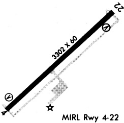
| Runways: | 04/22 |
| Longest Runway: | 04/22 is 3302 ft (1006 m) long |
| Runways with an Instrument Approach: |
7M5 Airport Runway Details
| Runway 04/22 | 3302 ft x 75 ft (1006 m x 23 m) | |
| Surface: | Asphalt - Good condition - No special surface treatment | |
| Runway Edge Lights: | Medium Intensity | |
Runway Weight Bearing Capacity (in thousands of pounds) |
||
| Single Wheel Landing Gear: | 12.0 | |
Runway 04 |
Runway 22 |
|
Elevation: |
606.0 | 648.0 |
Latitude: |
35-30-27.4240N | 35-30-49.5640N |
Longitude: |
093-50-36.1800W | 093-50-06.8250W |
|
Runway True Alignment: |
047 | 227 |
Glide Path Angle: |
3.0 degrees | 4.0 degrees |
Traffic Pattern: |
Left | Left |
Runway Markings Type: |
Nonprecision Instrument | Nonprecision Instrument |
Runway Markings Condition: |
Good | Good |
Object at End: |
BLDG | TREE |
Object Height: |
5 | 35 |
Distance from End: |
250 | 800 |
Object Centerline Offset: |
0 ft. left and right of centerline | 350 ft. right of centerline |
Visual Glide Slope Indicators: |
2-Light PAPI On Left Side Of Runway | 2-Light PAPI On Left Side Of Runway |
Threshold Crossing Height: |
17 | 22 |
Services
Airframe Repair: |
Major |
Powerplant Repair: |
Major |
Bottled Oxygen: |
None |
Bulk Oxygen: |
None |
Fuel Available: |
100LL, Jet A |
Landing Fees: |
No |
Parking: |
Hangars and tiedowns available |
Maps & Diagrams
7M5 Sectional
Flight Planning
at skyvector.com
at skyvector.com