Location
Latitude: |
35-28-14.4410N (35.470678) |
Longitude: |
093-25-37.7660W (-93.427157) |
Elevation: |
480.8 feet MSL (147 m MSL) |
Magnetic Variation: |
0.5 E (as of April 2024 from WMM2020 model) |
Time Zone: |
UTC -6.0 (Standard Time) UTC -5.0 (Daylight Savings Time) |
From City: |
03 N.M. E of Clarksville, Arkansas |
Found On: |
Memphis Chart |
FAA Region: |
ASW |
Contacts
Manager: |
Publicly owned: |
| JIM LOONEY 205 WALNUT CLARKSVILLE, AR 72830 479-264-8408 |
CITY OF CLARKSVILLE 205 WALNUT CLARKSVILLE, AR 72830 479-264-8408 |
Operations
Airport Status: |
Operational |
Facility Use: |
Public |
Type: |
Airport |
Activation Date: |
09/1941 |
Control tower: |
No |
Attendance (Months/Days/Hours): |
Months/Days/Hours ALL/ALL/DALGT |
Boundary ARTCC: |
ZME (Memphis) |
Responsible ARTCC: |
ZME (Memphis) |
Lighting Schedule: |
SEE RMK |
Segmented Circle Indicator: |
Yes |
Traffic Pattern Altitude (MSL): |
1481 feet (451 m) |
NOTAMs Facility: |
JBR |
NOTAM-D Service: |
Yes |
International Airport of Entry: |
No |
Customs Landing Rights: |
No |
Military Landing Rights: |
Yes |
Civil/Military Joint Use: |
No |
Based Aircraft
| Single Engine: | 20 |
| Multi Engine: | 1 |
| GA Helicopters: | 1 |
Annual Operations (as of 06/30/2021)
| Total Operations: | 12550 | |
| GA Local: | 7000 | 55.8% |
| GA Itinerant: | 5500 | 43.8% |
| Military Aircraft: | 50 | 0.4% |
Communications
| CTAF: | 122.800 |
| Unicom: | 122.800 |
- APCH/DEP SVC PRVDD BY MEMPHIS ARTCC ON FREQS 128.475/377.15 (RUSSELLVILLE RCAG).
Fixed Based Operators (FBOs) & Fuel
(Click on a business for detail)
Please help us keep this information up to date. This is a FREE SERVICE just like everything else on Airport Guide! If you see that a business needs to be added, modified, or deleted please fill out our Update Form.
To add, modify, or delete a business click here.
Please help us keep this information up to date. This is a FREE SERVICE just like everything else on Airport Guide! If you see that a business needs to be added, modified, or deleted please fill out our Update Form.
Area Code: 501 |
| Business Name | Frequency | Phone | Fuel Grade |
|---|---|---|---|
| Cloud 9 Aviation
Update FBO info |
754-8899, -7713 | 100LL, Jet A | |

|
Phillips | 100LL - 1.85 USD per gallon on 12/23/01 |
24 Hour Self Serve Credit Card Pumps |
|
|
Phillips | Jet A - 1.95 USD per gallon on 12/23/01 |
24 Hour Self Serve Credit Card Pumps |
Flight Service Stations
| Primary | Alternate | |
| FSS on Field: | N | |
| FSS Name (ID): | Jonesboro(JBR) | |
| Frequency: | ||
| Toll Free Phone: | 1-800-WX-BRIEF |
Instrument Procedures / Charts
FAA Terminal Procedures valid from 0901Z 03/21/24 to 0901Z 04/18/24.
There are various types of charts available for an airport. They are listed in the Page Type column. Here is a legend for those types:
APD - Airport Diagram
DP - Departure Procedure Charts
HOT - Hot Spots
IAP - Instrument Approach Procedure Charts
MIN - Minimums
STAR - Standard Terminal Arrival Charts
| Page Type | Page Name | Volume | Action Since Last Cycle |
|---|---|---|---|
| IAP | RNAV (GPS) RWY 09 | SC-1 | Changed |
| IAP | RNAV (GPS) RWY 27 | SC-1 | Changed |
| MIN | TAKEOFF MINIMUMS | SC-1 |
Terminal Procedures are only available for airports in several countries with more being added all the time. If you are looking for a specific country's charts, please send an email to support(at)airportguide.com stating the country name. This will be used to prioritize the implementation.
Navigation Aids (Navaids) near H35
| Dist (NM) | ID | Morse Code | Name | Type | Freq | True Hdg | Mag Hdg |
|---|---|---|---|---|---|---|---|
| 0.2 | CZE | _ . _ . _ _ . . . | Clarksville | NDB | 201 | 116 | 116 |
| 20.7 | RUE | . _ . . . _ . | Russellville | NDB | 379 | 128 | 128 |
| 32.4 | MPJ | _ _ . _ _ . . _ _ _ | Morrilton | NDB | 410 | 130 | 130 |
| 39.3 | FS | . . _ . . . . | Wizer | NDB | 223 | 259 | 258 |
| 41.6 | FSM | . . _ . . . . _ _ | Fort Smith | VORTAC | 110.40 | 263 | 262 |
| 45.1 | HR | . . . . . _ . | Bakky | NDB | 395 | 16 | 16 |
| 50.9 | DAK | _ . . . _ _ . _ | Drake | DME | 115.25 | 312 | 311 |
| 51.9 | HRO | . . . . . _ . _ _ _ | Harrison | VOR-DME | 112.50 | 11 | 11 |
| 52.0 | GK | _ _ . _ . _ | Jembo | NDB | 311 | 260 | 259 |
| 54.2 | CWS | _ . _ . . _ _ . . . | Conway | NDB | 302 | 115 | 115 |
| 57.5 | RZC | . _ . _ _ . . _ . _ . | Razorback | VORTAC | 116.40 | 324 | 323 |
| 61.8 | HOT | . . . . _ _ _ _ | Hot Springs | VOR-DME | 110.00 | 164 | 164 |
| 64.0 | HO | . . . . _ _ _ | Hossy | NDB | 385 | 169 | 169 |
| 64.3 | VM | . . . _ _ _ | Fench | NDB | 352 | 209 | 208 |
| 67.0 | IQS | . . _ _ . _ . . . | Sallisaw | NDB | 520 | 266 | 265 |
| 67.1 | RO | . _ . _ _ _ | Rogrs | NDB | 263 | 332 | 331 |
| 67.3 | SLG | . . . . _ . . _ _ . | Siloam Springs | NDB | 284 | 310 | 309 |
| 68.5 | FLP | . . _ . . _ . . . _ _ . | Flippin | DME | 116.05 | 43 | 43 |
| 70.5 | LRF | . _ . . . _ . . . _ . | Jacksonville | TACAN | 109.20 | 117 | 117 |
| 73.1 | LI | . _ . . . . | Lasky | NDB | 353 | 130 | 130 |
Nearby Airports with Fuel
Notices to Airmen (NOTAMS)
Remarks
| A110-1 | WILDLIFE ON & INVOF ARPT. |
| A110-2 | FOR CD CTC MEMPHIS ARTCC AT 901-368-8453/8449. |
| A16 | OR 479-243-6604 FOR MAINT. |
| A43-27 | PAPI UNUSBL BYD 8 DEGS RIGHT OF CNTRLN. |
| A70-FUEL-10 | 0LL SELF SRV FUEL AVBL 24 HRS WITH CREDIT CARD (100LL & JET A). |
| A81-APT | PAPI RWY 9 & 27 OPR CONSLY; MIRL RWY 09/27 ON SS-SR. |
Runways
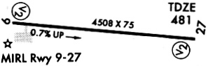
Runway Summary
| Runways: | 09/27 |
| Longest Runway: | 09/27 is 4504 ft (1373 m) long |
| Runways with an Instrument Approach: |
H35 Airport Runway Details
| Runway 09/27 | 4504 ft x 75 ft (1373 m x 23 m) | |
| Runway Length Source: | 3RD PARTY SURVEY as of 01/15/2020 | |
| Surface: | Asphalt - Excellent condition - No special surface treatment | |
| Runway Edge Lights: | Medium Intensity | |
Runway Weight Bearing Capacity (in thousands of pounds) |
||
| Single Wheel Landing Gear: | 19.0 | |
Runway 09 |
Runway 27 |
|
Elevation: |
448.4 | 480.8 |
Latitude: |
35-28-16.2906N | 35-28-12.5898N |
Longitude: |
093-26-04.8942W | 093-25-10.6375W |
|
Runway True Alignment: |
095 | 275 |
Glide Path Angle: |
4.0 degrees | 4.0 degrees |
Traffic Pattern: |
Left | Left |
Runway Markings Type: |
Nonprecision Instrument | Nonprecision Instrument |
Runway Markings Condition: |
Good | Good |
Object at End: |
TREES | TREE |
Object Height: |
70 | 60 |
Distance from End: |
900 | 900 |
Object Centerline Offset: |
280 ft. left of centerline | 275 ft. right of centerline |
Visual Glide Slope Indicators: |
2-Light PAPI On Left Side Of Runway | 2-Light PAPI On Left Side Of Runway |
Threshold Crossing Height: |
86 | 37 |
Services
Airframe Repair: |
Major |
Powerplant Repair: |
Major |
Bottled Oxygen: |
None |
Bulk Oxygen: |
None |
Fuel Available: |
100LL, Jet A |
Landing Fees: |
No |
Parking: |
Tiedowns available |
Maps & Diagrams
H35 Sectional
Flight Planning
at skyvector.com
at skyvector.com