Location
Latitude: |
35-26-17.7000N (35.43825) |
Longitude: |
094-48-10.5000W (-94.802917) |
Elevation: |
527.0 feet MSL (161 m MSL) |
Magnetic Variation: |
1.4 E (as of September 2024 from WMM2020 model) |
Time Zone: |
UTC -6.0 (Standard Time) UTC -5.0 (Daylight Savings Time) |
From City: |
01 N.M. SW of Sallisaw, Oklahoma |
Found On: |
Memphis Chart |
FAA Region: |
ASW |
Contacts
Manager: |
Publicly owned: |
| KEITH SKELTON 115 E. CHOCTAW, 1700 S. KERR BLVD SALLISAW, OK 74955 918-775-6241 |
CITY OF SALLISAW CITY HALL, 115 E.CHOCTAW SALLISAW, OK 74955 918-775-6241 |
Operations
Airport Status: |
Operational |
Facility Use: |
Public |
Type: |
Airport |
Control tower: |
No |
Attendance (Months/Days/Hours): |
Months/Days/Hours ALL/ALL/0800-1700 |
Boundary ARTCC: |
ZME (Memphis) |
Responsible ARTCC: |
ZME (Memphis) |
Lighting Schedule: |
SS-SR |
Segmented Circle Indicator: |
Yes |
Traffic Pattern Altitude (MSL): |
1527 feet (465 m) |
NOTAMs Facility: |
JSV |
NOTAM-D Service: |
Yes |
International Airport of Entry: |
No |
Customs Landing Rights: |
No |
Military Landing Rights: |
Yes |
Civil/Military Joint Use: |
No |
Based Aircraft
Annual Operations (as of )
Communications
| CTAF: | 122.700 |
| Unicom: | 122.700 |
| Approach: | RAZORBACK 120.9 120.9 MEMPHIS ARTCC |
| Departure: | RAZORBACK 120.9 120.9 MEMPHIS ARTCC |
| AWOS-3: | 118.475 (918-775-4136) |
- APCH/DEP SVC PRVDD BY MEMPHIS ARTCC ON FREQS 126.1/269.0 (FAYETTEVILLE RCAG) WHEN RAZORBACK APCH CTL CLSD.
Fixed Based Operators (FBOs) & Fuel
(Click on a business for detail)
Please help us keep this information up to date. This is a FREE SERVICE just like everything else on Airport Guide! If you see that a business needs to be added, modified, or deleted please fill out our Update Form.
To add, modify, or delete a business click here.
Please help us keep this information up to date. This is a FREE SERVICE just like everything else on Airport Guide! If you see that a business needs to be added, modified, or deleted please fill out our Update Form.
Area Code: 918 |
| Business Name | Frequency | Phone | Fuel Grade |
|---|---|---|---|
| Air Ride
Update FBO info |
775-5252 | ||
| Baron's Air Service
Update FBO info |
Unicom 122.7 | 775-2363 | 100LL |
Flight Service Stations
| Primary | Alternate | |
| FSS on Field: | N | |
| FSS Name (ID): | Mc Alester(MLC) | |
| Frequency: | ||
| Toll Free Phone: | 1-800-WX-BRIEF |
Instrument Procedures / Charts
FAA Terminal Procedures valid from 0901Z 09/05/24 to 0901Z 10/03/24.
There are various types of charts available for an airport. They are listed in the Page Type column. Here is a legend for those types:
APD - Airport Diagram
DP - Departure Procedure Charts
HOT - Hot Spots
IAP - Instrument Approach Procedure Charts
MIN - Minimums
STAR - Standard Terminal Arrival Charts
| Page Type | Page Name | Volume | Action Since Last Cycle |
|---|---|---|---|
| IAP | RNAV (GPS) RWY 35 | SC-1 | |
| MIN | TAKEOFF MINIMUMS | SC-1 |
Terminal Procedures are only available for airports in several countries with more being added all the time. If you are looking for a specific country's charts, please send an email to support(at)airportguide.com stating the country name. This will be used to prioritize the implementation.
Navigation Aids (Navaids) near KJSV
| Dist (NM) | ID | Morse Code | Name | Type | Freq | True Hdg | Mag Hdg |
|---|---|---|---|---|---|---|---|
| 2.4 | IQS | . . _ _ . _ . . . | Sallisaw | NDB | 520 | 169 | 168 |
| 17.5 | GK | _ _ . _ . _ | Jembo | NDB | 311 | 113 | 112 |
| 26.2 | FSM | . . _ . . . . _ _ | Fort Smith | VORTAC | 110.40 | 96 | 95 |
| 29.1 | FS | . . _ . . . . | Wizer | NDB | 223 | 99 | 98 |
| 31.0 | TQH | _ _ _ . _ . . . . | Tahlequah | NDB | 215 | 341 | 340 |
| 46.5 | PGO | . _ _ . _ _ . _ _ _ | Rich Mountain | VORTAC | 113.50 | 168 | 167 |
| 46.7 | DAK | _ . . . _ _ . _ | Drake | DME | 115.25 | 38 | 37 |
| 47.6 | SLG | . . . . _ . . _ _ . | Siloam Springs | NDB | 284 | 18 | 17 |
| 54.1 | OKM | _ _ _ _ . _ _ _ | Okmulgee | VOR-DME | 114.90 | 286 | 284 |
| 58.7 | RZC | . _ . _ _ . . _ . _ . | Razorback | VORTAC | 116.40 | 34 | 33 |
| 59.0 | OK | _ _ _ _ . _ | Preso | NDB | 388 | 289 | 287 |
| 59.2 | HET | . . . . . _ | Henryetta | NDB | 267 | 268 | 266 |
| 59.6 | MLC | _ _ . _ . . _ . _ . | Mc Alester | TACAN | 112.00 | 233 | 231 |
| 63.0 | ML | _ _ . _ . . | Wampa | NDB | 344 | 232 | 230 |
| 63.8 | GNP | _ _ . _ . . _ _ . | Glenpool | DME | 110.6 | 297 | 295 |
| 64.8 | VM | . . . _ _ _ | Fench | NDB | 352 | 146 | 145 |
| 66.0 | TU | _ . . _ | Oillr | NDB | 338 | 307 | 305 |
| 66.1 | TUL | _ . . _ . _ . . | Tulsa | VORTAC | 114.40 | 313 | 311 |
| 67.4 | CZE | _ . _ . _ _ . . . | Clarksville | NDB | 201 | 88 | 87 |
| 69.7 | TUL | _ . . _ . _ . . | Tulsa Intl | VOT | 109.00 | 311 | 309 |
Nearby Airports with Fuel
Notices to Airmen (NOTAMS)
Remarks
| A110-3 | +200 FT TOWER/ANT 2.2 MILES NORTH ON EXTDD CNTRLN. |
| A110-4 | FOR CD CTC RAZORBACK APCH 479-649-2416, WHEN APCH CLSD CTC MEMPHIS ARTCC AT 901-368-8453/8449. |
| A17 | ARPT UNATNDD FEDERAL HOLS. |
| A70-FUEL-10 | 0LL 100LL FUEL AVBL 24 HRS WITH A MAJOR CREDIT CARD. FOR JET A OR ADDNL SVCS CALL TOM HANING - 918-773-2076 |
Runways
Runway Summary
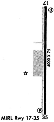
| Runways: | 17/35 |
| Longest Runway: | 17/35 is 4006 ft (1221 m) long |
| Runways with an Instrument Approach: |
KJSV Airport Runway Details
| Runway 17/35 | 4006 ft x 75 ft (1221 m x 23 m) | |
| Runway Length Source: | 3RD PARTY SURVEY as of 07/11/2012 | |
| Surface: | Asphalt - Good condition - No special surface treatment | |
| Runway Edge Lights: | Medium Intensity | |
Runway 17 |
Runway 35 |
|
Elevation: |
526.8 | 515.8 |
Latitude: |
35-26-37.5530N | 35-25-57.9367N |
Longitude: |
094-48-10.4053W | 094-48-10.5437W |
|
Runway True Alignment: |
180 | 000 |
Glide Path Angle: |
3.0 degrees | 3.0 degrees |
Traffic Pattern: |
Left | Left |
Runway Markings Type: |
Nonprecision Instrument | Nonprecision Instrument |
Runway Markings Condition: |
Good | Good |
Visual Glide Slope Indicators: |
2-Light PAPI On Right Side Of Runway | 2-Light PAPI On Left Side Of Runway |
Threshold Crossing Height: |
40 | 40 |
Services
Airframe Repair: |
Major |
Powerplant Repair: |
Major |
Bottled Oxygen: |
High Pressure |
Bulk Oxygen: |
None |
Fuel Available: |
100LL, Jet A |
Landing Fees: |
No |
Parking: |
Hangars and tiedowns available |
Maps & Diagrams
KJSV Sectional
Flight Planning
at skyvector.com
at skyvector.com