Location
Latitude: |
36-43-55.0370N (36.731955) |
Longitude: |
097-05-59.2160W (-97.099782) |
Elevation: |
1008.6 feet MSL (307 m MSL) |
Magnetic Variation: |
2.9 E (as of April 2024 from WMM2020 model) |
Time Zone: |
UTC -6.0 (Standard Time) UTC -5.0 (Daylight Savings Time) |
From City: |
02 N.M. NW of Ponca City, Oklahoma |
Found On: |
Wichita Chart |
FAA Region: |
ASW |
Contacts
Manager: |
Publicly owned: |
| DON NUZUM BOX 1450 PONCA CITY, OK 74602 580-767-0470 |
CITY OF PONCA CITY BOX 1450 PONCA CITY, OK 74602 580-767-0300 |
Operations
Airport Status: |
Operational |
Facility Use: |
Public |
Type: |
Airport |
Activation Date: |
11/1938 |
Control tower: |
No |
Attendance (Months/Days/Hours): |
Months/Days/Hours ALL/ALL/0700-1900 |
Boundary ARTCC: |
ZKC (Kansas City) |
Responsible ARTCC: |
ZKC (Kansas City) |
Lighting Schedule: |
SEE RMK |
Segmented Circle Indicator: |
Yes |
Traffic Pattern Altitude (MSL): |
2009 feet (612 m) |
NOTAMs Facility: |
PNC |
NOTAM-D Service: |
Yes |
International Airport of Entry: |
No |
Customs Landing Rights: |
No |
Military Landing Rights: |
Yes |
Civil/Military Joint Use: |
No |
Based Aircraft
| Single Engine: | 30 |
| Multi Engine: | 4 |
| Jet Engine: | 5 |
| GA Helicopters: | 1 |
Annual Operations (as of 05/10/2019)
| Total Operations: | 52000 | |
| GA Local: | 10000 | 19.2% |
| GA Itinerant: | 37000 | 71.2% |
| Military Aircraft: | 5000 | 9.6% |
Communications
| CTAF: | 123.000 |
| Unicom: | 123.000 |
| ASOS: | 134.075 (580-765-0049) |
- APCH/DEP CTL SVC PRVDD BY KANSAS CITY ARTCC (ZKC) ON FREQS 127.8/319.1 (PONCA CITY RCAG).
Fixed Based Operators (FBOs) & Fuel
(Click on a business for detail)
Please help us keep this information up to date. This is a FREE SERVICE just like everything else on Airport Guide! If you see that a business needs to be added, modified, or deleted please fill out our Update Form.
To add, modify, or delete a business click here.
Please help us keep this information up to date. This is a FREE SERVICE just like everything else on Airport Guide! If you see that a business needs to be added, modified, or deleted please fill out our Update Form.
Area Code: 580 |
| Business Name | Frequency | Phone | Fuel Grade |
|---|---|---|---|
| Greenwood Aviation
Update FBO info |
Unicom 123.0 | 762-2580 | 100LL, Jet A |
Flight Service Stations
| Primary | Alternate | |
| FSS on Field: | N | |
| FSS Name (ID): | Mc Alester(MLC) | |
| Frequency: | ||
| Toll Free Phone: | 1-800-WX-BRIEF |
Instrument Procedures / Charts
FAA Terminal Procedures valid from 0901Z 03/21/24 to 0901Z 04/18/24.
There are various types of charts available for an airport. They are listed in the Page Type column. Here is a legend for those types:
APD - Airport Diagram
DP - Departure Procedure Charts
HOT - Hot Spots
IAP - Instrument Approach Procedure Charts
MIN - Minimums
STAR - Standard Terminal Arrival Charts
| Page Type | Page Name | Volume | Action Since Last Cycle |
|---|---|---|---|
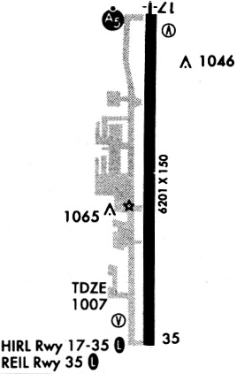
| IAP | ILS OR LOC RWY 17 | SC-1 | |
| IAP | RNAV (GPS) RWY 17 | SC-1 | |
| IAP | RNAV (GPS) RWY 35 | SC-1 | |
| IAP | VOR-A | SC-1 | |
| MIN | ALTERNATE MINIMUMS | SC-1 | |
| MIN | TAKEOFF MINIMUMS | SC-1 |
Terminal Procedures are only available for airports in several countries with more being added all the time. If you are looking for a specific country's charts, please send an email to support(at)airportguide.com stating the country name. This will be used to prioritize the implementation.
Navigation Aids (Navaids) near PNC
| Dist (NM) | ID | Morse Code | Name | Type | Freq | True Hdg | Mag Hdg |
|---|---|---|---|---|---|---|---|
| 3.0 | PER | . _ _ . . . _ . | Pioneer | VORTAC | 113.20 | 286 | 283 |
| 5.6 | PN | . _ _ . _ . | Ponca | NDB | 515 | 359 | 356 |
| 21.7 | SO | . . . _ _ _ | Sawcy | NDB | 353 | 8 | 5 |
| 29.8 | SW | . . . . _ _ | Gabeh | NDB | 255 | 178 | 175 |
| 30.5 | SWO | . . . . _ _ _ _ _ | Stillwater | VOR-DME | 108.40 | 178 | 175 |
| 38.1 | EGT | . _ _ . _ | Wellington | NDB | 414 | 338 | 335 |
| 39.5 | ODG | _ _ _ _ . . _ _ . | Woodring | VOR-DME | 109.00 | 237 | 234 |
| 43.2 | EI | . . . | Garfy | NDB | 341 | 230 | 227 |
| 45.8 | END | . _ . _ . . | Vance | VORTAC | 115.40 | 239 | 236 |
| 52.3 | BVO | _ . . . . . . _ _ _ _ | Bartlesville | VOR-DME | 117.90 | 82 | 79 |
| 52.6 | BV | _ . . . . . . _ | Dewie | NDB | 201 | 82 | 79 |
| 52.9 | CUH | _ . _ . . . _ . . . . | Cushing | NDB | 242 | 162 | 159 |
| 53.6 | IC | . . _ . _ . | Piche | NDB | 332 | 341 | 338 |
| 54.0 | IAB | . . . _ _ . . . | Mc Connell | TACAN | 116.50 | 351 | 348 |
| 56.6 | ICT | . . _ . _ . _ | Wichita | VOT | 114.00 | 343 | 340 |
| 56.6 | OWP | _ _ _ . _ _ . _ _ . | William Pogue | NDB | 362 | 126 | 123 |
| 57.4 | ANY | . _ _ . _ . _ _ | Anthony | TACAN | 112.90 | 296 | 293 |
| 61.9 | CQB | _ . _ . _ _ . _ _ . . . | Tilghman | NDB | 396 | 167 | 164 |
| 65.0 | ICT | . . _ . _ . _ | Wichita | VORTAC | 113.80 | 339 | 336 |
| 66.8 | TUL | _ . . _ . _ . . | Tulsa Intl | VOT | 109.00 | 118 | 116 |
Nearby Airports with Fuel
Notices to Airmen (NOTAMS)
Remarks
| A110-2 | ULTRALIGHTS ON & INVOF ARPT. |
| A110-3 | FOR CD IF UNA TO CTC ON FSS FREQ, CTC KANSAS CITY ARTCC AT 913-254-8508. |
| A31-17/35 | NORTH 2400 FT NSTD PLASTIC GROOVING ENTIRE WIDTH; 25 FT EACH EDGE REMAINING 4801 FT. |
| A43-35 | PAPI UNUSBL BYD 8 DEGS RIGHT OF CNTRLN. |
| A70-FUEL-10 | 0LL 100LL AVBL 24 HR.; JET A & SVC AVBL 0700-DUSK; OTR TIMES - 580-767-0429. |
| A81-APT | ACTVT MALSR RWY 17; ODALS RWY 35; HIRL RWY 17/35 - CTAF. PAPI RWY 17 & 35 ON CONSLY. |
| E111 | ESTABLISHED PRIOR TO 1958. |
Runways
Runway Summary
| Runways: | 17/35 |
| Longest Runway: | 17/35 is 7201 ft (2195 m) long |
| Runways with an Instrument Approach: | 17 |
PNC Airport Runway Details
| Runway 17/35 | 7201 ft x 100 ft (2195 m x 30 m) | |
| Runway Length Source: | 3RD PARTY SURVEY as of 03/13/2006 | |
| Surface: | Concrete - Good condition - Saw-cut or plastic grooved | |
| Runway Edge Lights: | High Intensity | |
Runway Weight Bearing Capacity (in thousands of pounds) |
||
| Single Wheel Landing Gear: | 51.0 | |
| Dual Wheel Landing Gear: | 65.0 | |
| Dual Tandem Wheel Landing Gear: | 122.0 | |
Runway 17 |
Runway 35 |
|
Elevation: |
993.7 | 1008.6 |
Latitude: |
36-44-30.6360N | 36-43-19.4375N |
Longitude: |
097-05-59.5018W | 097-05-58.9312W |
|
Runway True Alignment: |
180 | 360 |
ILS Type: |
ILS/DME | |
Glide Path Angle: |
3.0 degrees | 3.0 degrees |
Traffic Pattern: |
Right | Left |
Runway Markings Type: |
Precision Instrument | Precision Instrument |
Runway Markings Condition: |
Good | Fair |
Object at End: |
BLDG | |
Object Height: |
28 | |
Object Marked/Lighted?: |
Lighted | |
Distance from End: |
710 | |
Object Centerline Offset: |
555 ft. left of centerline | |
Visual Glide Slope Indicators: |
4-Light PAPI On Left Side Of Runway | 4-Light PAPI On Left Side Of Runway |
Approach Light System: |
1,400 Foot Medium Intensity Approach Lighting System With Runway Alignment Indicator Lights | Omnidirectional Approach Lighting System |
REIL: |
No | |
Threshold Crossing Height: |
52 | 46 |
Services
Airframe Repair: |
Major |
Powerplant Repair: |
Major |
Bottled Oxygen: |
High Pressure / Low Pressure |
Bulk Oxygen: |
High Pressure / Low Pressure |
Fuel Available: |
100LL, Jet A |
Landing Fees: |
No |
Parking: |
Hangars and tiedowns available |
Maps & Diagrams
PNC Sectional
Flight Planning
at skyvector.com
at skyvector.com