Location
Latitude: |
36-09-41.0020N (36.161389) |
Longitude: |
097-05-09.2160W (-97.085893) |
Elevation: |
1000.3 feet MSL (305 m MSL) |
Magnetic Variation: |
2.9 E (as of April 2024 from WMM2020 model) |
Time Zone: |
UTC -6.0 (Standard Time) UTC -5.0 (Daylight Savings Time) |
From City: |
03 N.M. NW of Stillwater, Oklahoma |
Found On: |
Wichita Chart |
FAA Region: |
ASW |
Contacts
Manager: |
Publicly owned: |
| KELLIE REED 3304 N AIRPORT INDUSTRIAL ACCESS RD STILLWATER, OK 74075 405-533-8425 |
CITY OF STILLWATER 723 SOUTH LEWIS STILLWATER, OK 74074 405-372-0025 |
Operations
Airport Status: |
Operational |
Facility Use: |
Public |
Type: |
Airport |
Activation Date: |
05/1943 |
Control tower: |
Yes |
Attendance (Months/Days/Hours): |
Months/Days/Hours ALL/ALL/0800-2200 |
Boundary ARTCC: |
ZKC (Kansas City) |
Responsible ARTCC: |
ZKC (Kansas City) |
Lighting Schedule: |
SEE RMK |
Segmented Circle Indicator: |
No |
Traffic Pattern Altitude (MSL): |
2000 feet (610 m) |
NOTAMs Facility: |
SWO |
NOTAM-D Service: |
Yes |
International Airport of Entry: |
No |
Customs Landing Rights: |
No |
Military Landing Rights: |
Yes |
Civil/Military Joint Use: |
No |
Aircraft Rescue and Firefighting: |
Class I ARFF Index: B Air Carrier Service: Scheduled Certification Date: 05/1973 |
Based Aircraft
| Single Engine: | 85 |
| Multi Engine: | 5 |
Annual Operations (as of 03/31/2022)
| Total Operations: | 81858 | |
| Commercial: | 51 | 0.1% |
| Air Taxi: | 2151 | 2.6% |
| GA Local: | 39631 | 48.4% |
| GA Itinerant: | 35105 | 42.9% |
| Military Aircraft: | 4920 | 6.0% |
Communications
| CTAF: | 125.350 |
| Unicom: | 122.950 |
| Tower: | STILLWATER 125.35 Hrs: 0800-2200 |
| Ground: | 121.6 |
| Approach: | KANSAS CITY ARTCC |
| Departure: | KANSAS CITY ARTCC |
| ASOS: | 135.725 (405-743-8150) |
- APCH/DEP CTL SVC PRVDD BY KANSAS CITY ARTCC (ZKC) ON FREQS 127.8/319.1 (PONCA CITY RCAG).
Fixed Based Operators (FBOs) & Fuel
(Click on a business for detail)
Please help us keep this information up to date. This is a FREE SERVICE just like everything else on Airport Guide! If you see that a business needs to be added, modified, or deleted please fill out our Update Form.
To add, modify, or delete a business click here.
Please help us keep this information up to date. This is a FREE SERVICE just like everything else on Airport Guide! If you see that a business needs to be added, modified, or deleted please fill out our Update Form.
Area Code: 405 |
| Business Name | Frequency | Phone | Fuel Grade |
|---|---|---|---|
| Delta Aviation
Update FBO info |
624-0719, -0955 | ||
| Stillwater Flight Center
Update FBO info |
Unicom 122.7 | 624-5463 | 100LL, Jet A |
| Stillwater Municipal Airport
Update FBO info |
Unicom 122.7 | 372-7881 | 100LL, Jet A |
Flight Service Stations
| Primary | Alternate | |
| FSS on Field: | N | |
| FSS Name (ID): | Mc Alester(MLC) | |
| Frequency: | ||
| Toll Free Phone: | 1-800-WX-BRIEF |
Instrument Procedures / Charts
FAA Terminal Procedures valid from 0901Z 03/21/24 to 0901Z 04/18/24.
There are various types of charts available for an airport. They are listed in the Page Type column. Here is a legend for those types:
APD - Airport Diagram
DP - Departure Procedure Charts
HOT - Hot Spots
IAP - Instrument Approach Procedure Charts
MIN - Minimums
STAR - Standard Terminal Arrival Charts
| Page Type | Page Name | Volume | Action Since Last Cycle |
|---|---|---|---|
| APD | AIRPORT DIAGRAM | SC-1 | |
| IAP | ILS OR LOC RWY 17 | SC-1 | |
| IAP | RNAV (GPS) RWY 17 | SC-1 | |
| IAP | RNAV (GPS) RWY 35 | SC-1 | |
| IAP | VOR RWY 17 | SC-1 | |
| IAP | VOR/DME RWY 35 | SC-1 | |
| MIN | ALTERNATE MINIMUMS | SC-1 | |
| MIN | TAKEOFF MINIMUMS | SC-1 |
Terminal Procedures are only available for airports in several countries with more being added all the time. If you are looking for a specific country's charts, please send an email to support(at)airportguide.com stating the country name. This will be used to prioritize the implementation.
Navigation Aids (Navaids) near SWO
| Dist (NM) | ID | Morse Code | Name | Type | Freq | True Hdg | Mag Hdg |
|---|---|---|---|---|---|---|---|
| 3.8 | SWO | . . . . _ _ _ _ _ | Stillwater | VOR-DME | 108.40 | 3 | 0 |
| 4.5 | SW | . . . . _ _ | Gabeh | NDB | 255 | 359 | 356 |
| 22.2 | CUH | _ . _ . . . _ . . . . | Cushing | NDB | 242 | 136 | 133 |
| 29.2 | CQB | _ . _ . _ _ . _ _ . . . | Tilghman | NDB | 396 | 153 | 150 |
| 34.8 | EI | . . . | Garfy | NDB | 341 | 281 | 278 |
| 35.3 | PER | . _ _ . . . _ . | Pioneer | VORTAC | 113.20 | 354 | 351 |
| 36.3 | ODG | _ _ _ _ . . _ _ . | Woodring | VOR-DME | 109.00 | 290 | 287 |
| 39.8 | PN | . _ _ . _ . | Ponca | NDB | 515 | 358 | 355 |
| 41.8 | END | . _ . _ . . | Vance | VORTAC | 115.40 | 285 | 282 |
| 42.6 | GGU | _ _ . _ _ . . . _ | Prague | NDB | 314 | 155 | 152 |
| 43.3 | HN | . . . . _ . | Suybe | NDB | 264 | 170 | 167 |
| 45.1 | OWP | _ _ _ . _ _ . _ _ . | William Pogue | NDB | 362 | 88 | 85 |
| 45.8 | TIK | _ . . _ . _ | Tinker | TACAN | 115.80 | 198 | 195 |
| 46.6 | PWA | . _ _ . . _ _ . _ | Wiley Post | VOR-DME | 113.40 | 216 | 213 |
| 48.5 | OK | _ _ _ _ . _ | Tuloo | NDB | 406 | 211 | 208 |
| 49.4 | IFI | . . . . _ . . . | Kingfisher | TACAN | 114.70 | 244 | 241 |
| 53.7 | OKC | _ _ _ _ . _ _ . _ . | Oklahoma Will Rgs W | VOT | 112.15 | 208 | 205 |
| 54.5 | IRW | . . . _ . . _ _ | Will Rogers | VORTAC | 114.10 | 208 | 205 |
| 55.7 | SO | . . . _ _ _ | Sawcy | NDB | 353 | 2 | 359 |
| 56.1 | GNP | _ _ . _ . . _ _ . | Glenpool | DME | 110.6 | 104 | 101 |
Nearby Airports with Fuel
Notices to Airmen (NOTAMS)
Remarks
| A110-10 | STUDENT OPS & BIRDS ON & INVOF ARPT. |
| A110-11 | ALL RAMPS UNCONTROLLED. |
| A110-12 | AFT HRS FUEL AVBL WITH PPR; CTC 405-624-5463. |
| A110-13 | FOR GA TSNT PRKG ON HANGAR 1 RAMP CTC FBO ON UNICOM OR FONE 405-624-5463. |
| A110-6 | ARFF INDEX B MAINTAINED; ARFF INDEX C PPR. |
| A110-7 | PTN OF TWY F NORTH OF T-HNGR 2 NOT VSBL FROM ATCT. |
| A110-8 | FOR CD IF UNA TO CTC ON FSS FREQ, CTC KANSAS CITY ARTCC AT 913-254-8508. |
| A17 | AFT HR FUEL - 405-377-5326. |
| A26 | 24 HRS PPR FOR UNSKED ACFT OPS WITH MORE THAN 9 PAX CALL AMGR 405-533-2222. |
| A35-17/35 | STRENGTHS BASED ON RESTRICTED OPS. |
| A43-04 | UNUSBL BYD 9 DEGS RIGHT OF CNTRLN. |
| A43-17 | UNUSBL BYD 9 DEGS LEFT & RIGHT OF CNTRLN. |
| A43-35 | UNUSBL BYD 9 DEGS LEFT & 8 DEGS RIGHT OF CNTRLN. |
| A81-APT | ACTVT MALSR RWY 17; REIL RWY 35; PAPI RWY 22; MIRL RWY 04/22 & 17/35 - CTAF. MIRL RWY 17/35 PRESET LOW INTST; INCR INTST - CTAF. |
| E111 | PRE DATES THE ACT. |
| E147 | TPA LGT ACFT 800 FT AGL, TURBO PROPS/JETS 1500 FT AGL. |
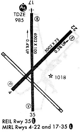
Runways
Runway Summary
| Runways: | 04/22 17/35 |
| Longest Runway: | 17/35 is 7401 ft (2256 m) long |
| Runways with an Instrument Approach: | 17 |
SWO Airport Runway Details
| Runway 04/22 | 5002 ft x 75 ft (1525 m x 23 m) | |
| Runway Length Source: | 3RD PARTY SURVEY as of 07/06/2021 | |
| Surface: | Asphalt - Good condition - No special surface treatment | |
| Runway Edge Lights: | Medium Intensity | |
Runway Weight Bearing Capacity (in thousands of pounds) |
||
| Single Wheel Landing Gear: | 34.0 | |
| Dual Wheel Landing Gear: | 60.0 | |
Runway 04 |
Runway 22 |
|
Elevation: |
960.9 | 985.7 |
Latitude: |
36-09-19.3252N | 36-09-54.6027N |
Longitude: |
097-05-26.0433W | 097-04-43.2883W |
|
Runway True Alignment: |
045 | 225 |
Glide Path Angle: |
3.0 degrees | 3.0 degrees |
Traffic Pattern: |
Left | Left |
Runway Markings Type: |
Basic | Basic |
Runway Markings Condition: |
Good | Good |
Object at End: |
GND | |
Object Height: |
3 | |
Distance from End: |
520 | |
Object Centerline Offset: |
0 ft. left and right of centerline | |
Visual Glide Slope Indicators: |
4-Light PAPI On Left Side Of Runway | 4-Light PAPI On Left Side Of Runway |
Threshold Crossing Height: |
35 | 39 |
Declared Distances |
||
Take Off Run Avbl. (TORA): |
5002 | 5002 |
Take Off Distance Avbl. (TODA): |
5002 | 5002 |
Actual Stop Dist. Avbl. (ASDA): |
5002 | 5002 |
Landing Dist. Avbl. (LDA): |
5002 | 5002 |
| Runway 17/35 | 7401 ft x 100 ft (2256 m x 30 m) | |
| Runway Length Source: | 3RD PARTY SURVEY as of 07/06/2021 | |
| Surface: | Asphalt - Good condition - Saw-cut or plastic grooved | |
| Runway Edge Lights: | Medium Intensity | |
Runway Weight Bearing Capacity (in thousands of pounds) |
||
| Single Wheel Landing Gear: | 100.0 | |
| Dual Wheel Landing Gear: | 157.0 | |
| Dual Tandem Wheel Landing Gear: | 310.0 | |
Runway 17 |
Runway 35 |
|
Elevation: |
1000.3 | 966.0 |
Latitude: |
36-10-20.3231N | 36-09-07.1396N |
Longitude: |
097-05-12.6886W | 097-05-11.8924W |
|
Runway True Alignment: |
179 | 359 |
ILS Type: |
ILS/DME | |
Glide Path Angle: |
3.0 degrees | 3.0 degrees |
Traffic Pattern: |
Left | Left |
Runway Markings Type: |
Precision Instrument | Precision Instrument |
Runway Markings Condition: |
Good | Good |
Object Centerline Offset: |
0 ft. left and right of centerline | |
Visual Glide Slope Indicators: |
4-Light PAPI On Left Side Of Runway | 4-Light PAPI On Left Side Of Runway |
Approach Light System: |
1,400 Foot Medium Intensity Approach Lighting System With Runway Alignment Indicator Lights | |
REIL: |
Yes | |
Threshold Crossing Height: |
50 | 38 |
Declared Distances |
||
Take Off Run Avbl. (TORA): |
7401 | 7401 |
Take Off Distance Avbl. (TODA): |
7401 | 7401 |
Actual Stop Dist. Avbl. (ASDA): |
7401 | 7401 |
Landing Dist. Avbl. (LDA): |
7401 | 7401 |
Services
Airframe Repair: |
Major |
Powerplant Repair: |
Major |
Fuel Available: |
100LL, Jet A |
Landing Fees: |
No |
Parking: |
Hangars and tiedowns available |
Maps & Diagrams
SWO Sectional
Flight Planning
at skyvector.com
at skyvector.com