Location
Latitude: |
37-09-35.6350N (37.159899) |
Longitude: |
098-04-46.2950W (-98.079526) |
Elevation: |
1343.1 feet MSL (409 m MSL) |
Magnetic Variation: |
3.5 E (as of April 2024 from WMM2020 model) |
Time Zone: |
UTC -6.0 (Standard Time) UTC -5.0 (Daylight Savings Time) |
From City: |
03 N.M. NW of Anthony, Kansas |
Found On: |
Wichita Chart |
FAA Region: |
ACE |
Contacts
Manager: |
Publicly owned: |
| CYNDRA KASTENS BOX 504 ANTHONY, KS 67003 (620) 842-5434 |
CITY OF ANTHONY BOX 504 ANTHONY, KS 67003 620-842-5434 |
Operations
Airport Status: |
Operational |
Facility Use: |
Public |
Type: |
Airport |
Activation Date: |
05/1941 |
Control tower: |
No |
Attendance (Months/Days/Hours): |
Months/Days/Hours Unattended |
Boundary ARTCC: |
ZKC (Kansas City) |
Responsible ARTCC: |
ZKC (Kansas City) |
Lighting Schedule: |
SEE RMK |
Segmented Circle Indicator: |
Yes |
Traffic Pattern Altitude (MSL): |
2343 feet (714 m) |
NOTAMs Facility: |
ICT |
NOTAM-D Service: |
Yes |
Military Landing Rights: |
Yes |
Civil/Military Joint Use: |
No |
Based Aircraft
| Single Engine: | 9 |
| Multi Engine: | 2 |
Annual Operations (as of 07/31/2018)
| Total Operations: | 6200 | |
| GA Local: | 3200 | 51.6% |
| GA Itinerant: | 3000 | 48.4% |
Communications
| CTAF: | 122.800 |
| Unicom: | 122.800 |
| Approach: | WICHITA 126.7 126.7 |
| Departure: | WICHITA 126.7 126.7 |
Fixed Based Operators (FBOs) & Fuel
(Click on a business for detail)
Please help us keep this information up to date. This is a FREE SERVICE just like everything else on Airport Guide! If you see that a business needs to be added, modified, or deleted please fill out our Update Form.
To add, modify, or delete a business click here.
Please help us keep this information up to date. This is a FREE SERVICE just like everything else on Airport Guide! If you see that a business needs to be added, modified, or deleted please fill out our Update Form.
Area Code: 620 |
| Business Name | Frequency | Phone | Fuel Grade |
|---|---|---|---|
| BTB Aircraft Services, Inc.
Update FBO info |
Unicom 122.8 | 842-5276 | 100LL |
Flight Service Stations
| Primary | Alternate | |
| FSS on Field: | N | |
| FSS Name (ID): | Wichita(ICT) | |
| Frequency: | ||
| Toll Free Phone: | 1-800-WX-BRIEF |
Instrument Procedures / Charts
FAA Terminal Procedures valid from 0901Z 03/21/24 to 0901Z 04/18/24.
There are various types of charts available for an airport. They are listed in the Page Type column. Here is a legend for those types:
APD - Airport Diagram
DP - Departure Procedure Charts
HOT - Hot Spots
IAP - Instrument Approach Procedure Charts
MIN - Minimums
STAR - Standard Terminal Arrival Charts
| Page Type | Page Name | Volume | Action Since Last Cycle |
|---|---|---|---|
| IAP | RNAV (GPS) RWY 18 | NC-2 | |
| IAP | RNAV (GPS) RWY 36 | NC-2 | |
| MIN | TAKEOFF MINIMUMS | NC-2 |
Terminal Procedures are only available for airports in several countries with more being added all the time. If you are looking for a specific country's charts, please send an email to support(at)airportguide.com stating the country name. This will be used to prioritize the implementation.
Navigation Aids (Navaids) near ANY
| Dist (NM) | ID | Morse Code | Name | Type | Freq | True Hdg | Mag Hdg |
|---|---|---|---|---|---|---|---|
| 4.4 | ANY | . _ _ . _ . _ _ | Anthony | TACAN | 112.90 | 269 | 265 |
| 34.4 | EGT | . _ _ . _ | Wellington | NDB | 414 | 73 | 70 |
| 38.9 | IC | . . _ . _ . | Piche | NDB | 332 | 49 | 46 |
| 42.0 | ICT | . . _ . _ . _ | Wichita | VOT | 114.00 | 46 | 43 |
| 42.3 | ICT | . . _ . _ . _ | Wichita | VORTAC | 113.80 | 33 | 30 |
| 46.5 | PTT | . _ _ . _ _ | Pratt | NDB | 356 | 317 | 313 |
| 47.6 | IAB | . . . _ _ . . . | Mc Connell | TACAN | 116.50 | 54 | 51 |
| 49.2 | ODG | _ _ _ _ . . _ _ . | Woodring | VOR-DME | 109.00 | 163 | 160 |
| 49.5 | END | . _ . _ . . | Vance | VORTAC | 115.40 | 170 | 167 |
| 50.1 | SO | . . . _ _ _ | Sawcy | NDB | 353 | 94 | 91 |
| 50.6 | PER | . _ _ . . . _ . | Pioneer | VORTAC | 113.20 | 119 | 116 |
| 50.7 | HUT | . . . . . . _ _ | Hutchinson | VOR-DME | 116.80 | 7 | 4 |
| 51.0 | PN | . _ _ . _ . | Ponca | NDB | 515 | 112 | 109 |
| 54.9 | EI | . . . | Garfy | NDB | 341 | 165 | 162 |
| 58.3 | HU | . . . . . . _ | Saltt | NDB | 404 | 7 | 4 |
| 66.4 | EWK | . . _ _ _ . _ | Newton | NDB | 281 | 34 | 31 |
| 67.0 | MDF | _ _ _ . . . . _ . | Mooreland | NDB | 284 | 233 | 229 |
| 70.4 | CA | _ . _ . . _ | Harvs | NDB | 395 | 32 | 29 |
| 71.6 | LYO | . _ . . _ . _ _ _ _ _ | Lyons | NDB | 386 | 354 | 350 |
| 73.1 | SW | . . . . _ _ | Gabeh | NDB | 255 | 138 | 135 |
Nearby Airports with Fuel
Notices to Airmen (NOTAMS)
Remarks
| A110-2 | PILOT LOUNGE ACCESS USE KEY CODE 134. |
| A110-3 | FOR CD IF UNA TO CTC ON FSS FREQ, CTC WICHITA APPCH AT 316-350-1520 |
| A32-10/28 | RWY 10/28 MOWED 300 FT WIDE. |
| A33-10/28 | RWY 10/28 SOFT AFTER RAIN. |
| A70-FUEL-10 | 0LL 24HR SELF SVC WITH CREDIT CARD. |
| A81-APT | LIRL RWY 18/36 PRESET LOW INTST; TO INCR INTST AND ACTVT PAPI RWY 18 & 36 - CTAF. |
| A83 | WIND INDICATOR RELCTD TO BCN TWR. |
| E111 | EXISTED PRIOR TO 1959. |
Runways
Runway Summary
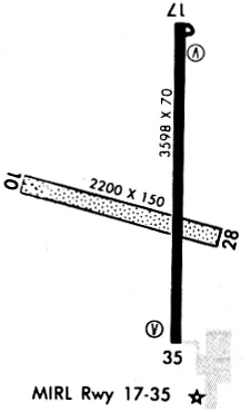
| Runways: | 10/28 18/36 |
| Longest Runway: | 18/36 is 5002 ft (1525 m) long |
| Runways with an Instrument Approach: |
ANY Airport Runway Details
| Runway 10/28 | 2212 ft x 150 ft (674 m x 46 m) | |
| Runway Length Source: | 3RD PARTY SURVEY as of 06/24/2020 | |
| Surface: | Turf - Good condition - No special surface treatment | |
Runway 10 |
Runway 28 |
|
Elevation: |
1329.6 | 1336.0 |
Latitude: |
37-09-31.9496N | 37-09-26.6589N |
Longitude: |
098-05-03.3575W | 098-04-36.8451W |
|
Runway True Alignment: |
104 | 284 |
Glide Path Angle: |
0.0 degrees | 0.0 degrees |
Traffic Pattern: |
Left | Left |
Runway Markings Type: |
None | None |
Runway Markings Condition: |
Fair | Fair |
Object at End: |
TREES | ROAD |
Object Height: |
68 | 13 |
Distance from End: |
315 | 300 |
Object Centerline Offset: |
0 ft. right of centerline | 0 ft. left and right of centerline |
| Runway 18/36 | 5002 ft x 75 ft (1525 m x 23 m) | |
| Runway Length Source: | 3RD PARTY SURVEY as of 06/24/2020 | |
| Surface: | Turf - Good condition - No special surface treatment | |
| Runway Pavement Class: | 11 /R/C/X/U | |
| Runway Edge Lights: | Low Intensity | |
Runway 18 |
Runway 36 |
|
Elevation: |
1343.0 | 1335.2 |
Latitude: |
37-10-03.1588N | 37-09-13.7101N |
Longitude: |
098-04-44.5122W | 098-04-44.7113W |
|
Runway True Alignment: |
180 | 000 |
Glide Path Angle: |
3.0 degrees | 3.0 degrees |
Traffic Pattern: |
Left | Left |
Runway Markings Type: |
Nonprecision Instrument | Nonprecision Instrument |
Runway Markings Condition: |
Fair | Fair |
Object at End: |
TREE | |
Object Height: |
34 | |
Distance from End: |
894 | |
Object Centerline Offset: |
0 ft. right of centerline | 0 ft. left and right of centerline |
Visual Glide Slope Indicators: |
2-Light PAPI On Left Side Of Runway | 2-Light PAPI On Left Side Of Runway |
Threshold Crossing Height: |
44 | 46 |
Services
Airframe Repair: |
Major |
Powerplant Repair: |
Major |
Bottled Oxygen: |
None |
Bulk Oxygen: |
Low Pressure |
Fuel Available: |
100LL, Jet A |
Landing Fees: |
No |
Parking: |
Hangars and tiedowns available |
Maps & Diagrams
ANY Sectional
Flight Planning
at skyvector.com
at skyvector.com