Location
Latitude: |
37-16-41.4710N (37.278186) |
Longitude: |
098-02-36.5220W (-98.043478) |
Elevation: |
1427.0 feet MSL (435 m MSL) |
Magnetic Variation: |
3.5 E (as of April 2024 from WMM2020 model) |
Time Zone: |
UTC -6.0 (Standard Time) UTC -5.0 (Daylight Savings Time) |
From City: |
01 N.M. SW of Harper, Kansas |
Found On: |
Wichita Chart |
FAA Region: |
ACE |
Contacts
Manager: |
Publicly owned: |
| KAREN BEFORT 201 WEST MAIN HARPER, KS 67058 620-896-2511 |
CITY OF HARPER 201 W. MAIN HARPER, KS 67058 620-896-2511 |
Operations
Airport Status: |
Operational |
Facility Use: |
Public |
Type: |
Airport |
Activation Date: |
06/1947 |
Control tower: |
No |
Attendance (Months/Days/Hours): |
Months/Days/Hours Unattended |
Boundary ARTCC: |
ZKC (Kansas City) |
Responsible ARTCC: |
ZKC (Kansas City) |
Lighting Schedule: |
SEE RMK |
Segmented Circle Indicator: |
No |
Traffic Pattern Altitude (MSL): |
2427 feet (740 m) |
NOTAMs Facility: |
ICT |
NOTAM-D Service: |
Yes |
International Airport of Entry: |
No |
Customs Landing Rights: |
No |
Civil/Military Joint Use: |
No |
Based Aircraft
| Single Engine: | 12 |
| Multi Engine: | 1 |
Annual Operations (as of 04/30/2021)
| Total Operations: | 3100 | |
| GA Local: | 2000 | 64.5% |
| GA Itinerant: | 1100 | 35.5% |
Communications
| CTAF: | 122.900 |
| Approach: | WICHITA 126.7 126.7 |
| Departure: | WICHITA 126.7 126.7 |
Fixed Based Operators (FBOs) & Fuel
(Click on a business for detail)
Please help us keep this information up to date. This is a FREE SERVICE just like everything else on Airport Guide! If you see that a business needs to be added, modified, or deleted please fill out our Update Form.
To add, modify, or delete a business click here.
Please help us keep this information up to date. This is a FREE SERVICE just like everything else on Airport Guide! If you see that a business needs to be added, modified, or deleted please fill out our Update Form.
Area Code: 620 |
| Business Name | Frequency | Phone | Fuel Grade |
|---|---|---|---|
| Harper Municipal Airport
Update FBO info |
896-2511 | 100LL |
Flight Service Stations
| Primary | Alternate | |
| FSS on Field: | N | |
| FSS Name (ID): | Wichita(ICT) | |
| Frequency: | ||
| Toll Free Phone: | 1-800-WX-BRIEF |
Instrument Procedures / Charts
FAA Terminal Procedures valid from 0901Z 03/21/24 to 0901Z 04/18/24.
There are various types of charts available for an airport. They are listed in the Page Type column. Here is a legend for those types:
APD - Airport Diagram
DP - Departure Procedure Charts
HOT - Hot Spots
IAP - Instrument Approach Procedure Charts
MIN - Minimums
STAR - Standard Terminal Arrival Charts
| Page Type | Page Name | Volume | Action Since Last Cycle |
|---|---|---|---|
| IAP | RNAV (GPS)-A | NC-2 | |
| MIN | TAKEOFF MINIMUMS | NC-2 |
Terminal Procedures are only available for airports in several countries with more being added all the time. If you are looking for a specific country's charts, please send an email to support(at)airportguide.com stating the country name. This will be used to prioritize the implementation.
Navigation Aids (Navaids) near 8K2
| Dist (NM) | ID | Morse Code | Name | Type | Freq | True Hdg | Mag Hdg |
|---|---|---|---|---|---|---|---|
| 9.4 | ANY | . _ _ . _ . _ _ | Anthony | TACAN | 112.90 | 220 | 216 |
| 31.3 | EGT | . _ _ . _ | Wellington | NDB | 414 | 84 | 81 |
| 33.3 | IC | . . _ . _ . | Piche | NDB | 332 | 57 | 54 |
| 35.6 | ICT | . . _ . _ . _ | Wichita | VORTAC | 113.80 | 37 | 34 |
| 36.1 | ICT | . . _ . _ . _ | Wichita | VOT | 114.00 | 53 | 50 |
| 42.3 | IAB | . . . _ _ . . . | Mc Connell | TACAN | 116.50 | 60 | 57 |
| 42.9 | PTT | . _ _ . _ _ | Pratt | NDB | 356 | 308 | 304 |
| 43.4 | HUT | . . . . . . _ _ | Hutchinson | VOR-DME | 116.80 | 6 | 3 |
| 49.5 | SO | . . . _ _ _ | Sawcy | NDB | 353 | 102 | 99 |
| 51.0 | HU | . . . . . . _ | Saltt | NDB | 404 | 6 | 3 |
| 52.7 | PN | . _ _ . _ . | Ponca | NDB | 515 | 120 | 117 |
| 53.0 | PER | . _ _ . . . _ . | Pioneer | VORTAC | 113.20 | 126 | 123 |
| 55.6 | ODG | _ _ _ _ . . _ _ . | Woodring | VOR-DME | 109.00 | 167 | 164 |
| 56.3 | END | . _ . _ . . | Vance | VORTAC | 115.40 | 173 | 170 |
| 59.7 | EWK | . . _ _ _ . _ | Newton | NDB | 281 | 37 | 34 |
| 61.4 | EI | . . . | Garfy | NDB | 341 | 168 | 165 |
| 63.5 | CA | _ . _ . . _ | Harvs | NDB | 395 | 34 | 31 |
| 64.7 | LYO | . _ . . _ . _ _ _ _ _ | Lyons | NDB | 386 | 352 | 348 |
| 66.4 | MPR | _ _ . _ _ . . _ . | Mc Pherson | NDB | 227 | 14 | 11 |
| 70.0 | GB | _ _ . _ . . . | Babsy | NDB | 419 | 326 | 322 |
Nearby Airports with Fuel
Notices to Airmen (NOTAMS)
Remarks
| A110*G | THIS AIRPORT HAS BEEN SURVEYED BY THE NATIONAL GEODETIC SURVEY. |
| A110-1 | PHONE AT FLD. |
| A110-2 | 30 INCH DITCH AER 12. |
| A110-4 | FOR CD CTC WICHITA APCH AT 316-350-1520. |
| A42-12 | MARKED WITH ORANGE CONES |
| A43-17 | RWY 17 PAPI UNUSBL BYD 3 DEGS L OF CNTRLN. |
| A70-FUEL-10 | 0LL CREDIT CARD SELF SER FUEL |
| A81-APT | APT LGT SKED: ACTVT HIRL AND PAPI RY 17/35 - CTAF. |
| E100 | AUTOMATED UNICOM; 3 CLICKS ADZY & WX, 4 CLICKS RADIO CHECK. ADZY ALSO AVBL BY CALLING 617-262-3825. |
| E111 | MAINT APCHS FOR A 20:1 GLIDE SLOPE AND TRSNL SFC FOR A 7:1 SLOPE. |
Runways
Runway Summary
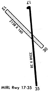
| Runways: | 12/30 17/35 |
| Longest Runway: | 17/35 is 3268 ft (996 m) long |
| Runways with an Instrument Approach: |
8K2 Airport Runway Details
| Runway 12/30 | 2138 ft x 160 ft (652 m x 49 m) | |
| Surface: | Turf - Good condition - No special surface treatment | |
Runway 12 |
Runway 30 |
|
Elevation: |
1426.0 | 1426.0 |
Latitude: |
37-16-52.7250N | 37-16-38.0770N |
Longitude: |
098-02-48.3850W | 098-02-29.3160W |
|
Runway True Alignment: |
134 | 314 |
Glide Path Angle: |
0.0 degrees | 0.0 degrees |
Traffic Pattern: |
Left | Left |
Runway Markings Condition: |
Good | |
Object at End: |
PLINE | PLINE |
Object Height: |
45 | 40 |
Distance from End: |
900 | 800 |
Object Centerline Offset: |
0 ft. left and right of centerline | 0 ft. left and right of centerline |
| Runway 17/35 | 3268 ft x 38 ft (996 m x 12 m) | |
| Surface: | Turf - Good condition - No special surface treatment | |
| Runway Edge Lights: | High Intensity | |
Runway 17 |
Runway 35 |
|
Elevation: |
1427.0 | 1424.0 |
Latitude: |
37-16-54.9680N | 37-16-22.8060N |
Longitude: |
098-02-36.9420W | 098-02-33.1060W |
|
Runway True Alignment: |
175 | 355 |
Glide Path Angle: |
3.2 degrees | 3.2 degrees |
Traffic Pattern: |
Left | Left |
Runway Markings Type: |
Basic | Basic |
Runway Markings Condition: |
Good | Good |
Object at End: |
TREE | PLINE |
Object Height: |
42 | 40 |
Distance from End: |
412 | 1600 |
Object Centerline Offset: |
0 ft. left and right of centerline | 0 ft. left and right of centerline |
Visual Glide Slope Indicators: |
2-Light PAPI On Left Side Of Runway | 2-Light PAPI On Left Side Of Runway |
Threshold Crossing Height: |
57 | 58 |
Services
Fuel Available: |
100LL |
Landing Fees: |
No |
Parking: |
Tiedowns available |
Maps & Diagrams
8K2 Sectional
Flight Planning
at skyvector.com
at skyvector.com