Location
Latitude: |
37-38-51.7000N (37.647694) |
Longitude: |
097-23-01.3000W (-97.383694) |
Elevation: |
1290.0 feet MSL (393 m MSL) |
Magnetic Variation: |
3.1 E (as of April 2024 from WMM2020 model) |
Time Zone: |
UTC -6.0 (Standard Time) UTC -5.0 (Daylight Savings Time) |
From City: |
03 N.M. SW of Wichita, Kansas |
Found On: |
Wichita Chart |
FAA Region: |
ACE |
Contacts
Manager: |
Privately owned: |
| EARL V. LONG 2558 S KESSLER WICHITA, KS 67217 316-943-5510 |
EARL V. LONG 2558 S KESSLER WICHITA, KS 67217 316-943-5510 |
Operations
Airport Status: |
Operational |
Facility Use: |
Public |
Type: |
Airport |
Activation Date: |
07/1947 |
Control tower: |
No |
Attendance (Months/Days/Hours): |
Months/Days/Hours ALL/ALL/DALGT |
Boundary ARTCC: |
ZKC (Kansas City) |
Responsible ARTCC: |
ZKC (Kansas City) |
Segmented Circle Indicator: |
No |
Traffic Pattern Altitude (MSL): |
2290 feet (698 m) |
NOTAMs Facility: |
ICT |
NOTAM-D Service: |
Yes |
International Airport of Entry: |
No |
Customs Landing Rights: |
No |
Military Landing Rights: |
No |
Civil/Military Joint Use: |
No |
Based Aircraft
| Single Engine: | 12 |
| Multi Engine: | 2 |
Annual Operations (as of 07/19/2019)
| Total Operations: | 860 | |
| GA Local: | 800 | 93.0% |
| GA Itinerant: | 60 | 7.0% |
Communications
| CTAF: | 122.900 |
Fixed Based Operators (FBOs) & Fuel
(Click on a business for detail)
Please help us keep this information up to date. This is a FREE SERVICE just like everything else on Airport Guide! If you see that a business needs to be added, modified, or deleted please fill out our Update Form.
To add, modify, or delete a business click here.
Please help us keep this information up to date. This is a FREE SERVICE just like everything else on Airport Guide! If you see that a business needs to be added, modified, or deleted please fill out our Update Form.
Area Code: 316 |
| Business Name | Frequency | Phone | Fuel Grade |
|---|---|---|---|
| Westport AG Sales & Service
Update FBO info |
Unicom 122.9 | 943-5510 | 100LL |
| Westport Airport
Update FBO info |
Unicom 122.9 | 943-5510 | 100LL |
Flight Service Stations
| Primary | Alternate | |
| FSS on Field: | N | |
| FSS Name (ID): | Wichita(ICT) | |
| Frequency: | ||
| Toll Free Phone: | 1-800-WX-BRIEF |
Instrument Procedures / Charts
Terminal Procedures are only available for airports in several countries with more being added all the time. If you are looking for a specific country's charts, please send an email to support(at)airportguide.com stating the country name. This will be used to prioritize the implementation.
Navigation Aids (Navaids) near 71K
| Dist (NM) | ID | Morse Code | Name | Type | Freq | True Hdg | Mag Hdg |
|---|---|---|---|---|---|---|---|
| 2.5 | ICT | . . _ . _ . _ | Wichita | VOT | 114.00 | 254 | 251 |
| 5.4 | IC | . . _ . _ . | Piche | NDB | 332 | 219 | 216 |
| 5.7 | IAB | . . . _ _ . . . | Mc Connell | TACAN | 116.50 | 105 | 102 |
| 11.2 | ICT | . . _ . _ . _ | Wichita | VORTAC | 113.80 | 301 | 298 |
| 19.4 | EGT | . _ _ . _ | Wellington | NDB | 414 | 180 | 177 |
| 25.5 | EWK | . . _ _ _ . _ | Newton | NDB | 281 | 11 | 8 |
| 30.3 | CA | _ . _ . . _ | Harvs | NDB | 395 | 9 | 6 |
| 33.5 | HUT | . . . . . . _ _ | Hutchinson | VOR-DME | 116.80 | 308 | 305 |
| 37.4 | SO | . . . _ _ _ | Sawcy | NDB | 353 | 153 | 150 |
| 38.4 | HU | . . . . . . _ | Saltt | NDB | 404 | 318 | 315 |
| 44.4 | MPR | _ _ . _ _ . . _ . | Mc Pherson | NDB | 227 | 341 | 338 |
| 47.6 | ANY | . _ _ . _ . _ _ | Anthony | TACAN | 112.90 | 232 | 229 |
| 51.2 | PN | . _ _ . _ . | Ponca | NDB | 515 | 164 | 161 |
| 55.1 | PER | . _ _ . . . _ . | Pioneer | VORTAC | 113.20 | 168 | 165 |
| 57.9 | LYO | . _ . . _ . _ _ _ _ _ | Lyons | NDB | 386 | 316 | 313 |
| 63.2 | SL | . . . . _ . . | Flory | NDB | 344 | 348 | 345 |
| 64.9 | PTT | . _ _ . _ _ | Pratt | NDB | 356 | 274 | 270 |
| 68.3 | HRU | . . . . . _ . . . _ | Herington | NDB | 407 | 23 | 20 |
| 70.4 | EMP | . _ _ . _ _ . | Emporia | VORTAC | 112.80 | 56 | 53 |
| 77.5 | SLN | . . . . _ . . _ . | Salina | VORTAC | 117.10 | 351 | 348 |
Nearby Airports with Fuel
Notices to Airmen (NOTAMS)
Remarks
| A110-1 | DEPS CTC WICHITA ATCT ON THE GROUND ON FREQ 125.7 FOR DEP INSTRUCTIONS. IF UNABLE - CONTACT ATCT ON FREQ 118.2 UPON DEP & REMAIN EAST OF THE FIELD UNTIL COMMUNICATIONS ARE ESTABLISHED. |
| A110-2 | FOR CD CTC WICHITA APCH AT 316-350-1520. |
| A33-17/35 | RWY 17/35 HAS GRASS ENCROACHING ON RWY SIDES NUMEROUS SURFACE CRACKS |
| A57-17 | APCH RATIO 28:1 TO DSPLCD THR. |
| A58-35 | +8 FT FENCE 50 FT FROM THR; BOTH SIDES OF CNTRLN. |
| E111 | PRVDD RT TFC PAT IS ESTABD FOR RWY & APCHS OF 20:1 & TRSNL SFC OF 7:1 ARE MAINT. |
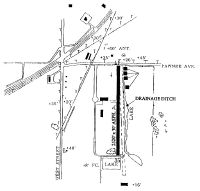
Runways
Runway Summary
| Runways: | 17/35 |
| Longest Runway: | 17/35 is 2520 ft (768 m) long |
| Runways with an Instrument Approach: |
71K Airport Runway Details
| Runway 17/35 | 2520 ft x 30 ft (768 m x 9 m) | |
| Surface: | Asphalt - Good condition - No special surface treatment | |
Runway Weight Bearing Capacity (in thousands of pounds) |
||
| Single Wheel Landing Gear: | 3.0 | |
Runway 17 |
Runway 35 |
|
Elevation: |
1290.0 | 1290.0 |
Latitude: |
37-39-04.1700N | 37-38-39.2500N |
Longitude: |
097-23-01.5500W | 097-23-01.0100W |
Glide Path Angle: |
0.0 degrees | 0.0 degrees |
Traffic Pattern: |
Left | Right |
Runway Markings Type: |
Basic | Basic |
Runway Markings Condition: |
Good | Good |
Object at End: |
BLDG | PLINE |
Object Height: |
22 | 40 |
Distance from End: |
230 | 1260 |
Object Centerline Offset: |
0 ft. left and right of centerline | 0 ft. left and right of centerline |
REIL: |
No | No |
Touchdown Lights: |
No | No |
Centerline Lights: |
No | No |
Displaced Threshold: |
400 |
Services
Airframe Repair: |
Major |
Powerplant Repair: |
Major |
Bottled Oxygen: |
Low Pressure |
Bulk Oxygen: |
None |
Fuel Available: |
100LL, Jet A |
Landing Fees: |
No |
Parking: |
Hangars and tiedowns available |
Maps & Diagrams
71K Sectional
Flight Planning
at skyvector.com
at skyvector.com