Location
Latitude: |
37-44-51.2670N (37.747574) |
Longitude: |
097-13-16.0240W (-97.221118) |
Elevation: |
1420.8 feet MSL (433 m MSL) |
Magnetic Variation: |
3 E (as of April 2024 from WMM2020 model) |
Time Zone: |
UTC -6.0 (Standard Time) UTC -5.0 (Daylight Savings Time) |
From City: |
09 N.M. NE of Wichita, Kansas |
Found On: |
Wichita Chart |
FAA Region: |
ACE |
Contacts
Manager: |
Publicly owned: |
| MR. JESSE R ROMO, A.A.E. 2173 AIR CARGO ROAD WICHITA, KS 67209 316-946-4700 |
WICHITA AIRPORT AUTHORITY 2173 AIR CARGO RD WICHITA, KS 67209 316-946-4700 |
Operations
Airport Status: |
Operational |
Facility Use: |
Public |
Type: |
Airport |
Activation Date: |
07/1944 |
Control tower: |
No |
Attendance (Months/Days/Hours): |
Months/Days/Hours ALL/ALL/ALL |
Boundary ARTCC: |
ZKC (Kansas City) |
Responsible ARTCC: |
ZKC (Kansas City) |
Lighting Schedule: |
SEE RMK |
Segmented Circle Indicator: |
Yes |
Traffic Pattern Altitude (MSL): |
2421 feet (738 m) |
NOTAMs Facility: |
AAO |
NOTAM-D Service: |
Yes |
International Airport of Entry: |
No |
Customs Landing Rights: |
No |
Military Landing Rights: |
Yes |
Civil/Military Joint Use: |
No |
Based Aircraft
| Single Engine: | 62 |
| Multi Engine: | 29 |
| Jet Engine: | 35 |
| GA Helicopters: | 1 |
| Military Aircraft: | 1 |
Annual Operations (as of 08/13/2019)
| Total Operations: | 38300 | |
| Air Taxi: | 1300 | 3.4% |
| GA Local: | 18000 | 47.0% |
| GA Itinerant: | 19000 | 49.6% |
Communications
| CTAF: | 122.700 |
| Unicom: | 122.700 |
| Clearance Del.: | 125.0 125.0 125.0 |
| Approach: | WICHITA |
| Departure: | WICHITA |
| ASOS: | 134.025 (316-636-2541) |
Fixed Based Operators (FBOs) & Fuel
(Click on a business for detail)
Please help us keep this information up to date. This is a FREE SERVICE just like everything else on Airport Guide! If you see that a business needs to be added, modified, or deleted please fill out our Update Form.
To add, modify, or delete a business click here.
Please help us keep this information up to date. This is a FREE SERVICE just like everything else on Airport Guide! If you see that a business needs to be added, modified, or deleted please fill out our Update Form.
Area Code: 316 |
| Business Name | Frequency | Phone | Fuel Grade |
|---|---|---|---|
| Midwest Corporate Avitation
Update FBO info |
122.7 | 636-9700, 800-435-9622 | 100LL, Jet A |

|
Phillips | 100LL - 2.86 USD per gallon on 4/13/02 |
Trucks |
|
|
Phillips | Jet A - 2.68 USD per gallon on 4/13/02 |
Trucks |
| RTR Corp.
Update FBO info |
636-4144 |
Flight Service Stations
| Primary | Alternate | |
| FSS on Field: | N | |
| FSS Name (ID): | Wichita(ICT) | |
| Frequency: | ||
| Toll Free Phone: | 1-800-WX-BRIEF |
Instrument Procedures / Charts
FAA Terminal Procedures valid from 0901Z 03/21/24 to 0901Z 04/18/24.
There are various types of charts available for an airport. They are listed in the Page Type column. Here is a legend for those types:
APD - Airport Diagram
DP - Departure Procedure Charts
HOT - Hot Spots
IAP - Instrument Approach Procedure Charts
MIN - Minimums
STAR - Standard Terminal Arrival Charts
| Page Type | Page Name | Volume | Action Since Last Cycle |
|---|---|---|---|
| IAP | ILS OR LOC RWY 18 | NC-2 | |
| IAP | RNAV (GPS) RWY 18 | NC-2 | |
| IAP | RNAV (GPS) RWY 36 | NC-2 | |
| IAP | RNAV (GPS)-E | NC-2 | |
| MIN | ALTERNATE MINIMUMS | NC-2 | |
| MIN | TAKEOFF MINIMUMS | NC-2 |
Terminal Procedures are only available for airports in several countries with more being added all the time. If you are looking for a specific country's charts, please send an email to support(at)airportguide.com stating the country name. This will be used to prioritize the implementation.
Navigation Aids (Navaids) near KAAO
| Dist (NM) | ID | Morse Code | Name | Type | Freq | True Hdg | Mag Hdg |
|---|---|---|---|---|---|---|---|
| 7.9 | IAB | . . . _ _ . . . | Mc Connell | TACAN | 116.50 | 196 | 193 |
| 12.1 | ICT | . . _ . _ . _ | Wichita | VOT | 114.00 | 236 | 233 |
| 15.1 | IC | . . _ . _ . | Piche | NDB | 332 | 227 | 224 |
| 17.2 | ICT | . . _ . _ . _ | Wichita | VORTAC | 113.80 | 269 | 266 |
| 19.2 | EWK | . . _ _ _ . _ | Newton | NDB | 281 | 352 | 349 |
| 24.0 | CA | _ . _ . . _ | Harvs | NDB | 395 | 353 | 350 |
| 26.7 | EGT | . _ _ . _ | Wellington | NDB | 414 | 197 | 194 |
| 36.9 | HUT | . . . . . . _ _ | Hutchinson | VOR-DME | 116.80 | 294 | 291 |
| 40.3 | HU | . . . . . . _ | Saltt | NDB | 404 | 304 | 301 |
| 40.4 | SO | . . . _ _ _ | Sawcy | NDB | 353 | 167 | 164 |
| 42.3 | MPR | _ _ . _ _ . . _ . | Mc Pherson | NDB | 227 | 328 | 325 |
| 55.7 | PN | . _ _ . _ . | Ponca | NDB | 515 | 174 | 171 |
| 57.4 | ANY | . _ _ . _ . _ _ | Anthony | TACAN | 112.90 | 232 | 229 |
| 59.5 | SL | . . . . _ . . | Flory | NDB | 344 | 340 | 337 |
| 59.6 | LYO | . _ . . _ . _ _ _ _ _ | Lyons | NDB | 386 | 307 | 304 |
| 59.9 | HRU | . . . . . _ . . . _ | Herington | NDB | 407 | 18 | 15 |
| 60.1 | PER | . _ _ . . . _ . | Pioneer | VORTAC | 113.20 | 177 | 174 |
| 60.7 | EMP | . _ _ . _ _ . | Emporia | VORTAC | 112.80 | 57 | 54 |
| 72.4 | PTT | . _ _ . _ _ | Pratt | NDB | 356 | 269 | 266 |
| 73.1 | SLN | . . . . _ . . _ . | Salina | VORTAC | 117.10 | 345 | 342 |
Nearby Airports with Fuel
Notices to Airmen (NOTAMS)
Remarks
| A110-11 | ATTENDED CONTINUOUSLY. |
| A110-12 | USE CTN FOR MCCONNELL AFB 9 MILES S AND BEECH FACTORY ARPT 3 MILES S. |
| A110-13 | BEECH FACTORY ARPT CLASS D ASP BEGINS 1 MILE S RWY 18. |
| A110-14 | SOUTHERLY AND SOUTHEASTERLY VFR ARR AND DEP NOT RCMDD WO ATC RADAR SVCS DUE TO BEECH FACTORY ARPT AND MCCONNELL AFB CLASS D AFB ASP. |
| A110-15 | VFR ARR AND DEP RECOMMENDED TO RMN AT OR BLW 2,500 MSL WITHIN 5 MILES DUE TO HEAVY MIL TFC 3,000 MSL. |
| A110-16 | DUE TO 20 RWY END ELEV DIFFERENTIAL, PILOTS MAY LOSE LINE OF SIGHT OF OTR ACFT ON OPPOSING RWY ENDS. |
| A110-17 | RWY 18 NSTD TFC PAT. |
| A110-18 | ALL TFC PATS W OF FLD. |
| A110-19 | RWY 36 DSGND CALM WIND RWY. |
| A110-21 | ACFT ENGINE RUNS ABOVE IDLE NOT APPROVED ON ACFT PRKG RAMPS. |
| A110-22 | PPR FOR ACFT CARRYING CLASS 1?DIVISION 1.1, 1.2 OR 1.3 EXPLOSIVES AS DEFINED BY 49 CFR 173.50 OR AS AMENDED. |
| A110-23 | MIGRATORY BIRDS ON AND IN VCNTY OF ARPT, ALL QUADS. |
| A70-FUEL-10 | 0LL FOR 24 HOUR FUEL CONTACT FBO |
| A81-APT | APT LGT SKED: ACTVT MIRL RY 18/36, MALSR RY 18, REIL RY 36 - CTAF. PAPI RYS 18 & 36 OPR CONT. |
| E111 | RWY 18/36 HAS NO OBJECTION. |
Runways
Runway Summary
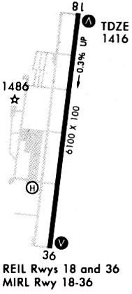
| Runways: | 18/36 |
| Longest Runway: | 18/36 is 6101 ft (1860 m) long |
| Runways with an Instrument Approach: | 18 |
KAAO Airport Runway Details
| Runway 18/36 | 6101 ft x 100 ft (1860 m x 30 m) | |
| Runway Length Source: | 3RD PARTY SURVEY as of 06/24/2020 | |
| Surface: | Concrete - Good condition - Saw-cut or plastic grooved | |
| Runway Pavement Class: | 15 /R/B/X/T | |
| Runway Edge Lights: | Medium Intensity | |
Runway Weight Bearing Capacity (in thousands of pounds) |
||
| Single Wheel Landing Gear: | 40.0 | |
| Dual Wheel Landing Gear: | 62.0 | |
Runway 18 |
Runway 36 |
|
Elevation: |
1401.2 | 1420.8 |
Latitude: |
37-45-21.2082N | 37-44-21.3262N |
Longitude: |
097-13-11.5011W | 097-13-20.5456W |
|
Runway True Alignment: |
187 | 007 |
ILS Type: |
ILS/DME | |
Glide Path Angle: |
3.0 degrees | 3.0 degrees |
Traffic Pattern: |
Right | |
Runway Markings Type: |
Precision Instrument | Nonprecision Instrument |
Runway Markings Condition: |
Good | Good |
Visual Glide Slope Indicators: |
4-Light PAPI On Left Side Of Runway | 4-Light PAPI On Left Side Of Runway |
Approach Light System: |
1,400 Foot Medium Intensity Approach Lighting System With Runway Alignment Indicator Lights | |
REIL: |
No | Yes |
Threshold Crossing Height: |
45 | 45 |
Services
Airframe Repair: |
None |
Powerplant Repair: |
None |
Bottled Oxygen: |
None |
Bulk Oxygen: |
None |
Fuel Available: |
100LL |
Parking: |
Hangars and tiedowns available |
Maps & Diagrams
KAAO Sectional
Flight Planning
at skyvector.com
at skyvector.com