Location
Latitude: |
37-38-59.8290N (37.649953) |
Longitude: |
097-25-58.9540W (-97.433043) |
Elevation: |
1332.6 feet MSL (406 m MSL) |
Magnetic Variation: |
3.1 E (as of April 2024 from WMM2020 model) |
Time Zone: |
UTC -6.0 (Standard Time) UTC -5.0 (Daylight Savings Time) |
From City: |
05 N.M. SW of Wichita, Kansas |
Found On: |
Wichita Chart |
FAA Region: |
ACE |
Contacts
Manager: |
Publicly owned: |
| MR. JESSE ROMO, A.A.E. 2173 AIR CARGO ROAD WICHITA, KS 67209 316-946-4700 |
WICHITA AIRPORT AUTHORITY 2173 AIR CARGO ROAD WICHITA, KS 67209 316-946-4700 |
Operations
Airport Status: |
Operational |
Facility Use: |
Public |
Type: |
Airport |
Activation Date: |
04/1953 |
Control tower: |
Yes |
Attendance (Months/Days/Hours): |
Months/Days/Hours ALL/ALL/ALL |
Boundary ARTCC: |
ZKC (Kansas City) |
Responsible ARTCC: |
ZKC (Kansas City) |
Segmented Circle Indicator: |
No |
Traffic Pattern Altitude (MSL): |
2333 feet (711 m) |
NOTAMs Facility: |
ICT |
NOTAM-D Service: |
Yes |
International Airport of Entry: |
No |
Customs Landing Rights: |
Yes |
Military Landing Rights: |
Yes |
Civil/Military Joint Use: |
No |
Aircraft Rescue and Firefighting: |
Class I ARFF Index: C Air Carrier Service: Scheduled Certification Date: 05/1973 |
Based Aircraft
| Single Engine: | 66 |
| Multi Engine: | 14 |
| Jet Engine: | 38 |
| GA Helicopters: | 4 |
Annual Operations (as of 04/30/2023)
| Total Operations: | 111658 | |
| Commercial: | 17295 | 15.5% |
| Air Taxi: | 18735 | 16.8% |
| GA Local: | 19176 | 17.2% |
| GA Itinerant: | 39194 | 35.1% |
| Military Aircraft: | 17258 | 15.5% |
Communications
| Unicom: | 122.950 |
| Tower: | WICHITA 118.2 257.8 Hrs: 24 |
| Clearance Del.: | 125.7 |
| Ground: | 121.9 348.6 |
| Approach: | WICHITA 125.5 ;270-009 BLW 5000 FT & BYD 20 NM 126.7 ;191-009 134.85 ;010-190 269.1 ;E IAB BLW 5000 FT 290.275 ;010-190 325.8 ;270-009 BLW 5000 FT & BYD 20 NM 353.5 ;191-009 Hrs: 24 327.1 |
| Departure: | WICHITA 125.5 ;270-009 BLW 5000 FT & BYD 20 NM 126.7 ;191-009 134.85 ;010-190 269.1 ;E IAB BLW 5000 FT 290.275 ;010-190 325.8 ;270-009 BLW 5000 FT & BYD 20 NM 353.5 ;191-009 Hrs: 24 327.1 |
| ATIS: | 125.15 Hrs: 24 |
| ASOS: | (316-945-8022) |
| EMERG: | 121.5 |
| CLASS C: | 134.85 ;010-190 ABV 4000 FT |
| EMERG: | 243.0 |
| CLASS C: | 353.5 ;191-009 |
| CLASS C: | 290.275 ;010-190 ABV 4000 FT |
| CLASS C: | 126.7 ;191-009 |
| RDR: | 317.425 |
| CLASS C: | 134.8 ;010-190 4000 FT & BLW |
Fixed Based Operators (FBOs) & Fuel
(Click on a business for detail)
Please help us keep this information up to date. This is a FREE SERVICE just like everything else on Airport Guide! If you see that a business needs to be added, modified, or deleted please fill out our Update Form.
To add, modify, or delete a business click here.
Please help us keep this information up to date. This is a FREE SERVICE just like everything else on Airport Guide! If you see that a business needs to be added, modified, or deleted please fill out our Update Form.
Area Code: 316 |
| Business Name | Frequency | Phone | Fuel Grade |
|---|---|---|---|
| Allied Signal CAS
Update FBO info |
943-9300 | ||
| Ballards Aviation, Inc.
Update FBO info |
946-4855, 800-525-5220 | ||
| Executive Aircraft Corporation
Update FBO info |
Unicom 122.95, Arinc 130.12 | 946-4990 | 100LL, Jet A |
| FlightSafety International
Website Update FBO info |
220-3100, 800-488-3214 | ||
| Raytheon Aircraft Services
Update FBO info |
Unicom 122.95, Arinc 130.57 | 946-4300 | 100LL, Jet A |
| Signature Flight Support
Update FBO info |
Arinc: 130.57 | +1 316 522 2010 | |
| Yingling Aircraft, Inc.
Update FBO info |
Unicom 122.95 | 943-3246, 800-835-0083 | 100LL, Jet A |
Flight Service Stations
| Primary | Alternate | |
| FSS on Field: | N | |
| FSS Name (ID): | Wichita(ICT) | |
| Frequency: | ||
| Toll Free Phone: | 1-800-WX-BRIEF |
Instrument Procedures / Charts
FAA Terminal Procedures valid from 0901Z 03/21/24 to 0901Z 04/18/24.
There are various types of charts available for an airport. They are listed in the Page Type column. Here is a legend for those types:
APD - Airport Diagram
DP - Departure Procedure Charts
HOT - Hot Spots
IAP - Instrument Approach Procedure Charts
MIN - Minimums
STAR - Standard Terminal Arrival Charts
| Page Type | Page Name | Volume | Action Since Last Cycle |
|---|---|---|---|
| APD | AIRPORT DIAGRAM | NC-2 | Changed |
| HOT | HOT SPOT | NC-2 | |
| IAP | ILS OR LOC RWY 01L | NC-2 | |
| IAP | ILS OR LOC RWY 01R | NC-2 | |
| IAP | ILS OR LOC RWY 19L | NC-2 | |
| IAP | ILS OR LOC RWY 19R | NC-2 | |
| IAP | ILS RWY 01L (CAT II) | NC-2 | |
| IAP | ILS RWY 01L (SA CAT I) | NC-2 | |
| IAP | NDB RWY 01R | NC-2 | |
| IAP | RNAV (GPS) RWY 01R | NC-2 | |
| IAP | RNAV (GPS) RWY 32 | NC-2 | |
| IAP | RNAV (GPS) Y RWY 01L | NC-2 | |
| IAP | RNAV (GPS) Y RWY 14 | NC-2 | |
| IAP | RNAV (GPS) Y RWY 19L | NC-2 | |
| IAP | RNAV (GPS) Y RWY 19R | NC-2 | |
| IAP | RNAV (RNP) Z RWY 01L | NC-2 | |
| IAP | RNAV (RNP) Z RWY 14 | NC-2 | |
| IAP | RNAV (RNP) Z RWY 19L | NC-2 | |
| IAP | RNAV (RNP) Z RWY 19R | NC-2 | |
| IAP | VOR RWY 14 | NC-2 | |
| MIN | ALTERNATE MINIMUMS | NC-2 | |
| MIN | TAKEOFF MINIMUMS | NC-2 |
Terminal Procedures are only available for airports in several countries with more being added all the time. If you are looking for a specific country's charts, please send an email to support(at)airportguide.com stating the country name. This will be used to prioritize the implementation.
Navigation Aids (Navaids) near ICT
| Dist (NM) | ID | Morse Code | Name | Type | Freq | True Hdg | Mag Hdg |
|---|---|---|---|---|---|---|---|
| 0.8 | ICT | . . _ . _ . _ | Wichita | VOT | 114.00 | 182 | 179 |
| 4.4 | IC | . . _ . _ . | Piche | NDB | 332 | 194 | 191 |
| 8.0 | IAB | . . . _ _ . . . | Mc Connell | TACAN | 116.50 | 102 | 99 |
| 9.2 | ICT | . . _ . _ . _ | Wichita | VORTAC | 113.80 | 308 | 305 |
| 19.7 | EGT | . _ _ . _ | Wellington | NDB | 414 | 174 | 171 |
| 26.0 | EWK | . . _ _ _ . _ | Newton | NDB | 281 | 16 | 13 |
| 30.6 | CA | _ . _ . . _ | Harvs | NDB | 395 | 13 | 10 |
| 31.6 | HUT | . . . . . . _ _ | Hutchinson | VOR-DME | 116.80 | 311 | 308 |
| 36.8 | HU | . . . . . . _ | Saltt | NDB | 404 | 320 | 317 |
| 38.6 | SO | . . . _ _ _ | Sawcy | NDB | 353 | 150 | 147 |
| 43.6 | MPR | _ _ . _ _ . . _ . | Mc Pherson | NDB | 227 | 344 | 341 |
| 45.9 | ANY | . _ _ . _ . _ _ | Anthony | TACAN | 112.90 | 230 | 227 |
| 52.0 | PN | . _ _ . _ . | Ponca | NDB | 515 | 162 | 159 |
| 55.8 | PER | . _ _ . . . _ . | Pioneer | VORTAC | 113.20 | 166 | 163 |
| 56.2 | LYO | . _ . . _ . _ _ _ _ _ | Lyons | NDB | 386 | 318 | 315 |
| 62.6 | PTT | . _ _ . _ _ | Pratt | NDB | 356 | 274 | 270 |
| 62.7 | SL | . . . . _ . . | Flory | NDB | 344 | 350 | 347 |
| 69.1 | HRU | . . . . . _ . . . _ | Herington | NDB | 407 | 24 | 21 |
| 72.3 | EMP | . _ _ . _ _ . | Emporia | VORTAC | 112.80 | 57 | 54 |
| 76.4 | GB | _ _ . _ . . . | Babsy | NDB | 419 | 298 | 294 |
Nearby Airports with Fuel
Notices to Airmen (NOTAMS)
Remarks
| A110-10 | TWY H CLSD TO ACFT WITH WINGSPAN MORE THAN 79. |
| A110-11 | TWY L AND L1 CLSD TO ACFT WITH WINGSPAN MORE THAN 118. |
| A110-12 | TWY P CLSD TO ACFT WITH WINGSPAN MORE THAN 79. |
| A110-13 | AIR CARGO RAMP CLSD TO ACFT WINGSPAN MORE THAN 148 FT. |
| A110-14 | ACFT PARKING BAS CONTACT 132.00 FOR PARKING INSTRUCTIONS PRIOR TO EXITING TWY L1. |
| A110-15 | FLIGHT NOTIFICATION SERVICE (ADCUS) AVBL. |
| A110-16 | AIRCRAFT ENGINE RUNS ABOVE IDLE NOT APPROVED ON AIRCRAFT PARKING RAMPS. |
| A110-17 | PPR REQUIRED FOR ACFT CARRYING CLASS 1DIVISION 1.1, 1.2 OR 1.3 EXPLOSIVES AS DEFINED BY 49 CFR 173.50 OR AS AMENDED. |
| A110-18 | MIGRATORY BIRDS ON AND IN VICINITY OF ARPT, ALL QUADS. |
| A110-3 | ATTENDED CONTINUOUSLY. |
| A110-4 | ATCT HAS LTD VIS OF TRML GATES 1 THRU 8, TWY H, AND CUSTOMS PRKG RAMP. |
| A110-8 | CALL FOR GATE PUSHBACK NOT REQUIRED. |
| A110-9 | TWYS F, G, H, J, P AND ALL ACFT PARKING RAMPS ARE NONMOVEMENT AREAS. |
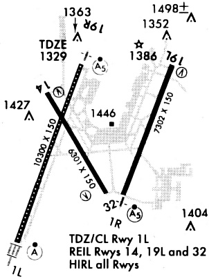
Runways
Runway Summary
| Runways: | 01L/19R 01R/19L 14/32 |
| Longest Runway: | 01L/19R is 10302 ft (3140 m) long |
| Runways with an Instrument Approach: | 01L, 19R, 01R, 19L |
ICT Airport Runway Details
| Runway 01L/19R | 10302 ft x 150 ft (3140 m x 46 m) | |
| Runway Length Source: | 3RD PARTY SURVEY as of 07/28/2021 | |
| Surface: | Concrete - Good condition - Saw-cut or plastic grooved | |
| Runway Pavement Class: | 72 /R/B/W/T | |
| Runway Edge Lights: | High Intensity | |
Runway Weight Bearing Capacity (in thousands of pounds) |
||
| Single Wheel Landing Gear: | 100.0 | |
| Dual Wheel Landing Gear: | 210.0 | |
| Dual Tandem Wheel Landing Gear: | 300.0 | |
Runway 01L |
Runway 19R |
|
Elevation: |
1312.5 | 1329.6 |
Latitude: |
37-38-06.0645N | 37-39-41.7663N |
Longitude: |
097-26-45.5906W | 097-26-01.7916W |
|
Runway True Alignment: |
020 | 200 |
ILS Type: |
ILS | ILS |
Glide Path Angle: |
0.0 degrees | 0.0 degrees |
Traffic Pattern: |
Left | Right |
Runway Markings Type: |
Precision Instrument | Precision Instrument |
Runway Markings Condition: |
Good | Good |
Runway Visual Range (RVR): |
Touchdown, Midfield, Rollout | Touchdown, Midfield, Rollout |
Approach Light System: |
Standard 2,400 Foot High Intensity Approach Lighting System With Sequenced Flashers, Cat. II or III Config. | 1,400 Foot Medium Intensity Approach Lighting System With Runway Alignment Indicator Lights |
Touchdown Lights: |
Yes | No |
Centerline Lights: |
Yes | Yes |
Declared Distances |
||
Take Off Run Avbl. (TORA): |
10301 | 10301 |
Take Off Distance Avbl. (TODA): |
10301 | 10301 |
Actual Stop Dist. Avbl. (ASDA): |
10301 | 10301 |
Landing Dist. Avbl. (LDA): |
10301 | 10301 |
| Runway 01R/19L | 7302 ft x 150 ft (2226 m x 46 m) | |
| Runway Length Source: | 3RD PARTY SURVEY as of 07/28/2021 | |
| Surface: | Concrete - Good condition - Saw-cut or plastic grooved | |
| Runway Pavement Class: | 66 /R/B/W/T | |
| Runway Edge Lights: | High Intensity | |
Runway Weight Bearing Capacity (in thousands of pounds) |
||
| Single Wheel Landing Gear: | 125.0 | |
| Dual Wheel Landing Gear: | 240.0 | |
| Dual Tandem Wheel Landing Gear: | 400.0 | |
Runway 01R |
Runway 19L |
|
Elevation: |
1321.0 | 1319.8 |
Latitude: |
37-38-33.9441N | 37-39-41.7709N |
Longitude: |
097-25-34.6296W | 097-25-03.5648W |
|
Runway True Alignment: |
020 | 200 |
ILS Type: |
ILS/DME | ILS/DME |
Glide Path Angle: |
0.0 degrees | 3.0 degrees |
Traffic Pattern: |
Right | Left |
Runway Markings Type: |
Precision Instrument | Precision Instrument |
Runway Markings Condition: |
Good | Good |
Visual Glide Slope Indicators: |
4-Light PAPI On Left Side Of Runway | |
Runway Visual Range (RVR): |
Touchdown, Rollout | Touchdown, Rollout |
Approach Light System: |
1,400 Foot Medium Intensity Approach Lighting System With Runway Alignment Indicator Lights | 1,400 Foot Medium Intensity Approach Lighting System With Runway Alignment Indicator Lights |
REIL: |
No | |
Touchdown Lights: |
No | No |
Threshold Crossing Height: |
55 | |
Declared Distances |
||
Take Off Run Avbl. (TORA): |
7302 | 7302 |
Take Off Distance Avbl. (TODA): |
7302 | 7302 |
Actual Stop Dist. Avbl. (ASDA): |
7302 | 7302 |
Landing Dist. Avbl. (LDA): |
7302 | 7302 |
| Runway 14/32 | 6301 ft x 150 ft (1921 m x 46 m) | |
| Runway Length Source: | 3RD PARTY SURVEY as of 07/28/2021 | |
| Surface: | Concrete - Good condition - Saw-cut or plastic grooved | |
| Runway Pavement Class: | 72 /R/B/W/T | |
| Runway Edge Lights: | High Intensity | |
Runway Weight Bearing Capacity (in thousands of pounds) |
||
| Single Wheel Landing Gear: | 100.0 | |
| Dual Wheel Landing Gear: | 190.0 | |
| Dual Tandem Wheel Landing Gear: | 280.0 | |
Runway 14 |
Runway 32 |
|
Elevation: |
1332.1 | 1321.6 |
Latitude: |
37-39-27.1620N | 37-38-33.2136N |
Longitude: |
097-26-24.2730W | 097-25-45.1001W |
|
Runway True Alignment: |
150 | 330 |
Glide Path Angle: |
3.0 degrees | 3.0 degrees |
Traffic Pattern: |
Left | Left |
Runway Markings Type: |
Nonprecision Instrument | Basic |
Runway Markings Condition: |
Good | Good |
Visual Glide Slope Indicators: |
4-Light PAPI On Left Side Of Runway | 4-Light PAPI On Left Side Of Runway |
REIL: |
Yes | Yes |
Threshold Crossing Height: |
50 | 53 |
Declared Distances |
||
Take Off Run Avbl. (TORA): |
6301 | 6301 |
Take Off Distance Avbl. (TODA): |
6301 | 6301 |
Actual Stop Dist. Avbl. (ASDA): |
6301 | 6301 |
Landing Dist. Avbl. (LDA): |
6301 | 6301 |
Services
Airframe Repair: |
Major |
Powerplant Repair: |
Major |
Bottled Oxygen: |
None |
Bulk Oxygen: |
None |
Fuel Available: |
100LL, Jet A |
Landing Fees: |
No |
Parking: |
Hangars and tiedowns available |
Other Services: |
Parachute rental |
Maps & Diagrams
ICT Sectional
Flight Planning
at skyvector.com
at skyvector.com