Location
Latitude: |
35-51-05.4818N (35.851523) |
Longitude: |
097-24-58.2392W (-97.416178) |
Elevation: |
1069.2 feet MSL (326 m MSL) |
Magnetic Variation: |
3.1 E (as of April 2024 from WMM2020 model) |
Time Zone: |
UTC -6.0 (Standard Time) UTC -5.0 (Daylight Savings Time) |
From City: |
02 N.M. S of Guthrie, Oklahoma |
Found On: |
Dallas-Ft Worth Chart |
FAA Region: |
ASW |
Contacts
Manager: |
Publicly owned: |
| CADEN YOUNG 520 AIRPORT RD GUTHRIE, OK 73044 405-282-2312 |
CITY OF GUTHRIE PO BOX 908, 101 N. SECOND ST. GUTHRIE, OK 73044 405-282-0488 |
Operations
Airport Status: |
Operational |
Facility Use: |
Public |
Type: |
Airport |
Activation Date: |
07/1941 |
Control tower: |
No |
Attendance (Months/Days/Hours): |
Months/Days/Hours ALL/ALL/0600-1800 |
Boundary ARTCC: |
ZKC (Kansas City) |
Responsible ARTCC: |
ZFW (Fort Worth) |
Lighting Schedule: |
SEE RMK |
Segmented Circle Indicator: |
Yes |
Traffic Pattern Altitude (MSL): |
2069 feet (631 m) |
NOTAMs Facility: |
GOK |
NOTAM-D Service: |
Yes |
International Airport of Entry: |
No |
Customs Landing Rights: |
No |
Military Landing Rights: |
Yes |
Civil/Military Joint Use: |
No |
Based Aircraft
| Single Engine: | 97 |
| Multi Engine: | 8 |
| Jet Engine: | 3 |
Annual Operations (as of 06/15/2022)
| Total Operations: | 23000 | |
| GA Local: | 17250 | 75.0% |
| GA Itinerant: | 5730 | 24.9% |
| Military Aircraft: | 20 | 0.1% |
Communications
| CTAF: | 122.800 |
| Unicom: | 122.800 |
| Approach: | OKE CITY 124.2 124.2 |
| Departure: | OKE CITY 124.2 124.2 |
| ASOS: | 133.975 (405-282-0478) |
Fixed Based Operators (FBOs) & Fuel
(Click on a business for detail)
Please help us keep this information up to date. This is a FREE SERVICE just like everything else on Airport Guide! If you see that a business needs to be added, modified, or deleted please fill out our Update Form.
To add, modify, or delete a business click here.
Please help us keep this information up to date. This is a FREE SERVICE just like everything else on Airport Guide! If you see that a business needs to be added, modified, or deleted please fill out our Update Form.
Area Code: 405 |
| Business Name | Frequency | Phone | Fuel Grade |
|---|---|---|---|
| Crabtree Aircraft Co.
Update FBO info |
Unicom 122.8 | 282-4250, -4256 | 100LL, Jet A |
Flight Service Stations
| Primary | Alternate | |
| FSS on Field: | N | |
| FSS Name (ID): | Mc Alester(MLC) | |
| Frequency: | ||
| Toll Free Phone: | 1-800-WX-BRIEF |
Instrument Procedures / Charts
FAA Terminal Procedures valid from 0901Z 03/21/24 to 0901Z 04/18/24.
There are various types of charts available for an airport. They are listed in the Page Type column. Here is a legend for those types:
APD - Airport Diagram
DP - Departure Procedure Charts
HOT - Hot Spots
IAP - Instrument Approach Procedure Charts
MIN - Minimums
STAR - Standard Terminal Arrival Charts
| Page Type | Page Name | Volume | Action Since Last Cycle |
|---|---|---|---|
| IAP | RNAV (GPS) RWY 16 | SC-1 | |
| IAP | RNAV (GPS) RWY 34 | SC-1 | |
| MIN | ALTERNATE MINIMUMS | SC-1 | |
| MIN | TAKEOFF MINIMUMS | SC-1 | |
| STAR | GULLI THREE | SC-1 | |
| STAR | GULLI THREE[DELIMITER] CONT.1 | SC-1 |
Terminal Procedures are only available for airports in several countries with more being added all the time. If you are looking for a specific country's charts, please send an email to support(at)airportguide.com stating the country name. This will be used to prioritize the implementation.
Navigation Aids (Navaids) near GOK
| Dist (NM) | ID | Morse Code | Name | Type | Freq | True Hdg | Mag Hdg |
|---|---|---|---|---|---|---|---|
| 22.2 | PWA | . _ _ . . _ _ . _ | Wiley Post | VOR-DME | 113.40 | 210 | 207 |
| 24.6 | OK | _ _ _ _ . _ | Tuloo | NDB | 406 | 202 | 199 |
| 25.0 | TIK | _ . . _ . _ | Tinker | TACAN | 115.80 | 175 | 172 |
| 27.6 | SWO | . . . . _ _ _ _ _ | Stillwater | VOR-DME | 108.40 | 35 | 32 |
| 28.1 | SW | . . . . _ _ | Gabeh | NDB | 255 | 34 | 31 |
| 28.7 | IFI | . . . . _ . . . | Kingfisher | TACAN | 114.70 | 264 | 261 |
| 30.1 | CQB | _ . _ . _ _ . _ _ . . . | Tilghman | NDB | 396 | 104 | 101 |
| 30.2 | OKC | _ _ _ _ . _ _ . _ . | Oklahoma Will Rgs W | VOT | 112.15 | 197 | 194 |
| 31.0 | IRW | . . . _ . . _ _ | Will Rogers | VORTAC | 114.10 | 197 | 194 |
| 31.2 | EI | . . . | Garfy | NDB | 341 | 324 | 321 |
| 31.3 | CUH | _ . _ . . . _ . . . . | Cushing | NDB | 242 | 85 | 82 |
| 33.4 | HN | . . . . _ . | Suybe | NDB | 264 | 136 | 133 |
| 34.4 | RG | . _ . _ _ . | Gally | NDB | 350 | 194 | 191 |
| 36.2 | ODG | _ _ _ _ . . _ _ . | Woodring | VOR-DME | 109.00 | 330 | 327 |
| 36.3 | OUN | _ _ _ . . _ _ . | Norman | NDB | 370 | 184 | 181 |
| 38.3 | END | . _ . _ . . | Vance | VORTAC | 115.40 | 320 | 317 |
| 39.5 | GGU | _ _ . _ _ . . . _ | Prague | NDB | 314 | 120 | 117 |
| 50.2 | HMY | . . . . _ _ _ . _ _ | Muldrow | NDB | 512 | 169 | 166 |
| 50.2 | SRE | . . . . _ . . | Seminole | NDB | 278 | 133 | 130 |
| 55.1 | PER | . _ _ . . . _ . | Pioneer | VORTAC | 113.20 | 12 | 9 |
Nearby Airports with Fuel
Notices to Airmen (NOTAMS)
Remarks
| A110-3 | FOR CD CTC OKE CITY APCH AT 405-681-5683 |
| A110-4 | CTN: BIRD AND OTR WILDLIFE ACT ON AND INVOF ARPT. |
| A30-16/34 | RWY 16 CALM WIND RWY. |
| A75 | FOR HNGR AVBLTY CTC FBO (405) 282-4250. |
| A81-APT | ACTVT ODALS RWY 16; REIL RWY 34 - CTAF. MIRL RWY 16/34 SS-SR PRESET MED INTST; INCR INTST - CTAF. PAPI RWY 16 & 34 ON CONSLY. |
| E111 | ESTABLISHED PRIOR TO 1958 |
Runways
Runway Summary
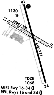
| Runways: | 16/34 |
| Longest Runway: | 16/34 is 5001 ft (1524 m) long |
| Runways with an Instrument Approach: |
GOK Airport Runway Details
| Runway 16/34 | 5001 ft x 75 ft (1524 m x 23 m) | |
| Runway Length Source: | 3RD PARTY SURVEY as of 05/13/2007 | |
| Surface: | Concrete - Good condition - No special surface treatment | |
| Runway Edge Lights: | Medium Intensity | |
Runway Weight Bearing Capacity (in thousands of pounds) |
||
| Single Wheel Landing Gear: | 30.0 | |
| Dual Wheel Landing Gear: | 48.0 | |
| Dual Tandem Wheel Landing Gear: | 78.0 | |
Runway 16 |
Runway 34 |
|
Elevation: |
1049.6 | 1066.0 |
Latitude: |
35-51-29.3540N | 35-50-41.6096N |
Longitude: |
097-25-06.1622W | 097-24-50.3161W |
|
Runway True Alignment: |
165 | 345 |
Glide Path Angle: |
3.0 degrees | 3.0 degrees |
Traffic Pattern: |
Left | Left |
Runway Markings Type: |
Nonprecision Instrument | Nonprecision Instrument |
Runway Markings Condition: |
Good | Good |
Object at End: |
TREES | |
Object Height: |
22 | |
Distance from End: |
475 | |
Object Centerline Offset: |
237 ft. left of centerline | |
Visual Glide Slope Indicators: |
4-Light PAPI On Left Side Of Runway | 4-Light PAPI On Left Side Of Runway |
Approach Light System: |
Omnidirectional Approach Lighting System | |
REIL: |
Yes | Yes |
Threshold Crossing Height: |
45 | 45 |
Services
Airframe Repair: |
None |
Powerplant Repair: |
None |
Bottled Oxygen: |
None |
Bulk Oxygen: |
None |
Fuel Available: |
100LL |
Landing Fees: |
No |
Parking: |
Tiedowns available |
Maps & Diagrams
GOK Sectional
Flight Planning
at skyvector.com
at skyvector.com