Location
Latitude: |
46-52-17.9000N (46.871639) |
Longitude: |
068-01-05.5000W (-68.018194) |
Elevation: |
620.3 feet MSL (189 m MSL) |
Magnetic Variation: |
16.2 W (as of April 2024 from WMM2020 model) |
Time Zone: |
UTC -5.0 (Standard Time) UTC -4.0 (Daylight Savings Time) |
From City: |
01 N.M. NW of Caribou, Maine |
Found On: |
Halifax Chart |
FAA Region: |
ANE |
Contacts
Manager: |
Publicly owned: |
| DAVE QUELLETTE 25 HIGH STREET CARIBOU, ME 04736 207-493-3324 |
CITY OF CARIBOU 25 HIGH STREET CARIBOU, ME 04736 207-493-3324 |
Operations
Airport Status: |
Operational |
Facility Use: |
Public |
Type: |
Airport |
Activation Date: |
04/1940 |
Control tower: |
No |
Attendance (Months/Days/Hours): |
Months/Days/Hours ALL/ALL/Unattended |
Boundary ARTCC: |
ZBW (Boston) |
Responsible ARTCC: |
ZBW (Boston) |
Lighting Schedule: |
SEE RMK |
Segmented Circle Indicator: |
Yes |
Traffic Pattern Altitude (MSL): |
1620 feet (494 m) |
NOTAMs Facility: |
CAR |
NOTAM-D Service: |
Yes |
International Airport of Entry: |
Yes |
Customs Landing Rights: |
No |
Military Landing Rights: |
Yes |
Civil/Military Joint Use: |
No |
Based Aircraft
| Single Engine: | 10 |
Annual Operations (as of 08/11/2021)
| Total Operations: | 3200 | |
| GA Local: | 2000 | 62.5% |
| GA Itinerant: | 1200 | 37.5% |
Communications
| CTAF: | 122.800 |
| Unicom: | 122.800 |
| ASOS: | 135.125 (207-496-3153) |
- APCH/DEP SVC PRVDD BY BOSTON ARTCC ON FREQ 124.75/239.05 (CARIBOU RCAG).
- CLNC DEL PRVDD BY BOSTON ARTCC ON FREQ 124.75.
Fixed Based Operators (FBOs) & Fuel
(Click on a business for detail)
Please help us keep this information up to date. This is a FREE SERVICE just like everything else on Airport Guide! If you see that a business needs to be added, modified, or deleted please fill out our Update Form.
To add, modify, or delete a business click here.
Please help us keep this information up to date. This is a FREE SERVICE just like everything else on Airport Guide! If you see that a business needs to be added, modified, or deleted please fill out our Update Form.
Area Code: 207 |
| Business Name | Frequency | Phone | Fuel Grade |
|---|---|---|---|
| Caribou Air, Inc.
Update FBO info |
Unicom 122.8 | 493-4237 | 100LL |
Flight Service Stations
| Primary | Alternate | |
| FSS on Field: | N | |
| FSS Name (ID): | Bangor(BGR) | |
| Frequency: | ||
| Toll Free Phone: | 1-800-WX-BRIEF |
Instrument Procedures / Charts
FAA Terminal Procedures valid from 0901Z 03/21/24 to 0901Z 04/18/24.
There are various types of charts available for an airport. They are listed in the Page Type column. Here is a legend for those types:
APD - Airport Diagram
DP - Departure Procedure Charts
HOT - Hot Spots
IAP - Instrument Approach Procedure Charts
MIN - Minimums
STAR - Standard Terminal Arrival Charts
| Page Type | Page Name | Volume | Action Since Last Cycle |
|---|---|---|---|
| IAP | RNAV (GPS) RWY 01 | NE-1 | |
| IAP | RNAV (GPS) RWY 19 | NE-1 | |
| MIN | ALTERNATE MINIMUMS | NE-1 | |
| MIN | TAKEOFF MINIMUMS | NE-1 |
Terminal Procedures are only available for airports in several countries with more being added all the time. If you are looking for a specific country's charts, please send an email to support(at)airportguide.com stating the country name. This will be used to prioritize the implementation.
Navigation Aids (Navaids) near CAR
| Dist (NM) | ID | Morse Code | Name | Type | Freq | True Hdg | Mag Hdg |
|---|---|---|---|---|---|---|---|
| 6.6 | PQI | . _ _ . _ _ . _ . . | Presque Isle | VOR-DME | 116.40 | 208 | 224 |
| 15.7 | PQ | . _ _ . _ _ . _ | Excal | NDB | 278 | 180 | 196 |
| 50.5 | HUL | . . . . . . _ . _ . . | Houlton | DME | 116.1 | 171 | 187 |
| 76.6 | LNT | . _ . . _ . _ | Milnot | NDB | 344 | 196 | 212 |
| 79.8 | MLT | _ _ . _ . . _ | Millinocket | VOR-DME | 117.90 | 195 | 211 |
| 82.0 | FC | Fredericton | NDB | 326 | 133 | 149 | |
| 83.0 | RI | Riviere Du Loup | NDB | 201 | 310 | 326 | |
| 83.1 | YRI | Riviere Du Loup | VOR | 113.90 | 310 | 326 | |
| 85.8 | IDC | Fredericton | DME | 111.30 | 134 | 150 | |
| 88.4 | YFC | _ . _ _ . . _ . _ . _ . | Fredericton | VORTAC | 113.00 | 130 | 146 |
| 93.5 | PNN | . _ _ . _ . _ . | Princeton | DME | 114.3 | 171 | 187 |
| 93.7 | CL | Charlo | NDB | 207 | 42 | 59 | |
| 98.3 | YXK | Rimouski | NDB | 373 | 348 | 364 |
Nearby Airports with Fuel
| Dist (NM) | Name (Airport IDs) | True Hdg | Mag Hdg | Fuel Grade |
|---|---|---|---|---|
| 11.0 | Presque Isle International Airport (PQI KPQI PQI) |
185 | 201 | 100LL, Jet A |
| 21.2 | Long Lake Seaplane Base (92B) |
335 | 351 | MOGAS |
| 27.6 | Northern Aroostook Regional Airport (WFK KFVE FVE) |
334 | 350 | 100LL, Jet A |
| 45.8 | Houlton International Airport (HUL KHUL HUL) |
168 | 184 | 100LL, Jet A, Jet A+ |
| 51.9 | Shin Pond Seaplane Base (85B) |
205 | 221 | 100LL |
| 76.7 | Millinocket Seaplane Base (70B) |
206 | 222 | 100LL |
| 78.5 | Millinocket Municipal Airport (MLT KMLT MLT) |
200 | 216 | 100LL, Jet A |
Notices to Airmen (NOTAMS)
Remarks
| A110-1 | RWY 01/19 OBSTN LGTS ALG BOTH SIDES OF PRIM SFC AND TREE LN. |
| A110-3 | RWY 01 +23 FT PWR POLE AND TREES APRXLY 950 FT FM THR ACRS APCH. |
| A110-4 | FOR CD IF UNA TO CTC ON FSS FREQ, CTC BOSTON ARTCC AT 603-879-6859 . |
| A50-29 | 524 FT DTHR; +302 FT BLAST PAD BYD END OF RWY. |
| A57-29 | 24:1 RATIO TO DTHR. |
| A58-01 | GND 0-200 FT FM EOR 100-250 FT R OF CNTRLN RISING TO +8 FT. |
| A58-29 | GND ON BOTH SIDES RISING TO +3 FT 200 FT FM RWY END. |
| A70-FUEL-10 | 0LL 24 HR FUEL AVBL WITH CREDIT CARD. |
| A75 | CALL 207-493-3324 FOR HNGR AVBL. |
| A81-APT | ACTVT MIRL RWY 01/19 & 11/29 - CTAF. |
| E111 | EXISTED PRIOR TO 1959. |
| E147 | 800 FT AGL LGT ACFT; 1000 FT AGL MULTI & LRG SNGL ENG ACFT. |
Runways
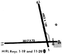
Runway Summary
| Runways: | 01/19 11/29 |
| Longest Runway: | 01/19 is 4003 ft (1220 m) long |
| Runways with an Instrument Approach: |
CAR Airport Runway Details
| Runway 01/19 | 4003 ft x 100 ft (1220 m x 30 m) | |
| Runway Length Source: | 3RD PARTY SURVEY as of 07/07/2010 | |
| Surface: | Asphalt - Good condition - No special surface treatment | |
| Runway Edge Lights: | Medium Intensity | |
Runway Weight Bearing Capacity (in thousands of pounds) |
||
| Single Wheel Landing Gear: | 30.0 | |
Runway 01 |
Runway 19 |
|
Elevation: |
614.1 | 617.3 |
Latitude: |
46-52-05.6577N | 46-52-44.2008N |
Longitude: |
068-00-53.7773W | 068-01-06.4643W |
|
Runway True Alignment: |
347 | 167 |
Glide Path Angle: |
0.0 degrees | 0.0 degrees |
Traffic Pattern: |
Left | Left |
Runway Markings Type: |
Nonprecision Instrument | Nonprecision Instrument |
Runway Markings Condition: |
Fair | Fair |
Object at End: |
GND | |
Object Height: |
7 | |
Distance from End: |
201 | |
Object Centerline Offset: |
149 ft. right of centerline |
| Runway 11/29 | 3016 ft x 75 ft (919 m x 23 m) | |
| Runway Length Source: | 3RD PARTY SURVEY as of 07/07/2010 | |
| Surface: | Asphalt - Good condition - No special surface treatment | |
| Runway Edge Lights: | Medium Intensity | |
Runway Weight Bearing Capacity (in thousands of pounds) |
||
| Single Wheel Landing Gear: | 30.0 | |
Runway 11 |
Runway 29 |
|
Elevation: |
620.0 | 619.3 |
Latitude: |
46-52-07.8587N | 46-52-09.1502N |
Longitude: |
068-01-34.2207W | 068-00-50.8512W |
|
Runway True Alignment: |
088 | 268 |
Glide Path Angle: |
0.0 degrees | 0.0 degrees |
Traffic Pattern: |
Left | Left |
Runway Markings Type: |
Basic | Basic |
Runway Markings Condition: |
Good | Good |
Object at End: |
BLDG | |
Object Height: |
34 | |
Object Marked/Lighted?: |
Lighted | |
Distance from End: |
398 | |
Object Centerline Offset: |
149 ft. right of centerline | |
REIL: |
No | |
Touchdown Lights: |
No | |
Centerline Lights: |
No | |
Threshold Elevation: |
615.3 | |
Displaced Threshold: |
398 | |
Threshold Latitude: |
46-52-08.9800N | |
Threshold Longitude: |
068-00-56.5800W |
Services
Airframe Repair: |
None |
Powerplant Repair: |
None |
Bottled Oxygen: |
None |
Bulk Oxygen: |
None |
Fuel Available: |
100LL, Jet A |
Landing Fees: |
No |
Parking: |
Hangars and tiedowns available |
Maps & Diagrams
CAR Sectional
Flight Planning
at skyvector.com
at skyvector.com