Location
Latitude: |
41-18-25.8000N (41.307167) |
Longitude: |
085-03-51.7000W (-85.064361) |
Elevation: |
880.4 feet MSL (268 m MSL) |
Magnetic Variation: |
6 W (as of April 2024 from WMM2020 model) |
Time Zone: |
UTC -5.0 (Standard Time) UTC -4.0 (Daylight Savings Time) |
From City: |
03 N.M. S of Auburn, Indiana |
Found On: |
Chicago Chart |
FAA Region: |
AGL |
Contacts
Manager: |
Publicly owned: |
| RUSS COUCHMAN 2710 CR 60 SUITE 200 AUBURN, IN 46706 260-927-8876 |
DE KALB COUNTY AIRPORT AUTHORITY 2710 CR 60 SUITE 200 AUBURN, IN 46706 260-927-8876 |
Operations
Airport Status: |
Operational |
Facility Use: |
Public |
Type: |
Airport |
Activation Date: |
10/1964 |
Control tower: |
No |
Attendance (Months/Days/Hours): |
Months/Days/Hours ALL/ALL/0700-2100 |
Boundary ARTCC: |
ZAU (Chicago) |
Responsible ARTCC: |
ZAU (Chicago) |
Lighting Schedule: |
SEE RMK |
Segmented Circle Indicator: |
No |
Traffic Pattern Altitude (MSL): |
1880 feet (573 m) |
NOTAMs Facility: |
HUF |
NOTAM-D Service: |
Yes |
International Airport of Entry: |
No |
Customs Landing Rights: |
No |
Military Landing Rights: |
Yes |
Civil/Military Joint Use: |
No |
Based Aircraft
| Single Engine: | 41 |
| Multi Engine: | 4 |
| Jet Engine: | 7 |
| GA Helicopters: | 2 |
Annual Operations (as of 12/31/2019)
| Total Operations: | 12416 | |
| Air Taxi: | 745 | 6.0% |
| GA Local: | 10429 | 84.0% |
| GA Itinerant: | 1242 | 10.0% |
Communications
| CTAF: | 123.000 |
| Unicom: | 123.000 |
| Clearance Del.: | 126.6 126.6 126.6 126.6 126.6 126.6 |
| Approach: | FORT WAYNE |
| Departure: | FORT WAYNE |
| AWOS-3: | 124.15 (260-925-8225) |
- APCH CTL SECTORIZATION BASED UPON FORT WAYNE RWY USAGE.
Fixed Based Operators (FBOs) & Fuel
(Click on a business for detail)
Please help us keep this information up to date. This is a FREE SERVICE just like everything else on Airport Guide! If you see that a business needs to be added, modified, or deleted please fill out our Update Form.
To add, modify, or delete a business click here.
Please help us keep this information up to date. This is a FREE SERVICE just like everything else on Airport Guide! If you see that a business needs to be added, modified, or deleted please fill out our Update Form.
Area Code: 219 |
| Business Name | Frequency | Phone | Fuel Grade |
|---|---|---|---|
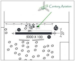
| Bowman Aviation, Inc.
Update FBO info |
Unicom 123.0 | 925-4831 | 100LL, Jet A |
Flight Service Stations
| Primary | Alternate | |
| FSS on Field: | N | |
| FSS Name (ID): | Terre Haute(HUF) | |
| Frequency: | ||
| Toll Free Phone: | 1-800-WX-BRIEF |
Instrument Procedures / Charts
FAA Terminal Procedures valid from 0901Z 03/21/24 to 0901Z 04/18/24.
There are various types of charts available for an airport. They are listed in the Page Type column. Here is a legend for those types:
APD - Airport Diagram
DP - Departure Procedure Charts
HOT - Hot Spots
IAP - Instrument Approach Procedure Charts
MIN - Minimums
STAR - Standard Terminal Arrival Charts
| Page Type | Page Name | Volume | Action Since Last Cycle |
|---|---|---|---|
| IAP | ILS OR LOC RWY 27 | EC-2 | |
| IAP | RNAV (GPS) RWY 09 | EC-2 | |
| IAP | RNAV (GPS) RWY 27 | EC-2 | |
| IAP | VOR-A | EC-2 | |
| MIN | ALTERNATE MINIMUMS | EC-2 | |
| MIN | TAKEOFF MINIMUMS | EC-2 |
Terminal Procedures are only available for airports in several countries with more being added all the time. If you are looking for a specific country's charts, please send an email to support(at)airportguide.com stating the country name. This will be used to prioritize the implementation.
Navigation Aids (Navaids) near KGWB
| Dist (NM) | ID | Morse Code | Name | Type | Freq | True Hdg | Mag Hdg |
|---|---|---|---|---|---|---|---|
| 5.4 | GW | _ _ . . _ _ | Shenk | NDB | 227 | 89 | 95 |
| 19.9 | OLK | _ _ _ . _ . . _ . _ | Webster Lake | VOR | 110.40 | 259 | 265 |
| 20.0 | ANQ | . _ _ . _ _ . _ | Angola | NDB | 347 | 357 | 363 |
| 20.5 | FWA | . . _ . . _ _ . _ | Fort Wayne | VORTAC | 117.80 | 195 | 201 |
| 20.6 | FWA | . . _ . . _ _ . _ | Fort Wayne Baer | VOT | 111.00 | 196 | 202 |
| 32.6 | HHG | . . . . . . . . _ _ . | Huntington | NDB | 417 | 213 | 219 |
| 33.5 | VFU | . . . _ . . _ . . . _ | Stanley | NDB | 411 | 142 | 148 |
| 34.6 | IRS | . . . _ . . . . | Sturgis | NDB | 382 | 331 | 337 |
| 45.3 | GSH | _ _ . . . . . . . . | Goshen | VORTAC | 113.70 | 287 | 293 |
| 45.6 | USE | . . _ . . . . | Fulton | NDB | 375 | 66 | 72 |
| 45.7 | HAI | . . . . . _ . . | Three Rivers | NDB | 407 | 328 | 334 |
| 46.5 | IWH | . . . _ _ . . . . | Wabash | NDB | 329 | 225 | 231 |
| 47.3 | LFD | . _ . . . . _ . _ . . | Litchfield | VOR-DME | 111.20 | 16 | 22 |
| 53.5 | TO | _ _ _ _ | Tophr | NDB | 219 | 73 | 79 |
| 53.7 | AZ | . _ _ _ . . | Austn | NDB | 371 | 337 | 343 |
| 54.5 | CQA | _ . _ . _ _ . _ . _ | Lakefield | NDB | 205 | 155 | 161 |
| 55.7 | ADG | . _ _ . . _ _ . | Adrian | NDB | 278 | 52 | 58 |
| 56.2 | MZZ | _ _ _ _ . . _ _ . . | Marion | VOR-DME | 108.60 | 209 | 215 |
| 57.1 | SB | . . . _ . . . | Misha | NDB | 341 | 295 | 301 |
| 59.4 | TOL | _ _ _ _ . _ . . | Toledo | TACAN | 112.50 | 72 | 78 |
Nearby Airports with Fuel
Notices to Airmen (NOTAMS)
Remarks
| A110-1 | FOR CD CTC CHICAGO ARTCC AT 630-906-8921. |
| A110-3 | WINTER SN REMOVAL OPS. FICON UNMNT WHEN UNATNDD; AFT HR - AMGR. |
| A17 | AFT HR - 260-299-5492. |
| A30-09/27 | RWY 27 CALM WIND RWY. |
| A81-APT | ACTVT MALSR RWY 27; REIL RWY 09 & 27; MIRL RWY 09/27 - CTAF. DUSK TO DAWN: MIRL RWY 09/27 PRESET LOW INTST; INCR INTST - CTAF. PAPI RWY 09 & 27 ON CONSLY. |
Runways
Runway Summary
| Runways: | 09/27 |
| Longest Runway: | 09/27 is 5000 ft (1524 m) long |
| Runways with an Instrument Approach: | 27 |
KGWB Airport Runway Details
| Runway 09/27 | 5000 ft x 100 ft (1524 m x 30 m) | |
| Surface: | Asphalt - Good condition - Saw-cut or plastic grooved | |
| Runway Edge Lights: | Medium Intensity | |
Runway Weight Bearing Capacity (in thousands of pounds) |
||
| Single Wheel Landing Gear: | 60.0 | |
| Dual Wheel Landing Gear: | 90.0 | |
| Dual Tandem Wheel Landing Gear: | 120.0 | |
Runway 09 |
Runway 27 |
|
Elevation: |
870.4 | 879.2 |
Latitude: |
41-18-25.4919N | 41-18-26.0752N |
Longitude: |
085-04-24.4068W | 085-03-18.9129W |
|
Runway True Alignment: |
089 | 269 |
ILS Type: |
ILS/DME | |
Glide Path Angle: |
3.0 degrees | 3.0 degrees |
Traffic Pattern: |
Left | Left |
Runway Markings Type: |
Nonprecision Instrument | Precision Instrument |
Runway Markings Condition: |
Fair | Fair |
Object Centerline Offset: |
0 ft. left and right of centerline | |
Visual Glide Slope Indicators: |
2-Light PAPI On Left Side Of Runway | 2-Light PAPI On Left Side Of Runway |
Approach Light System: |
1,400 Foot Medium Intensity Approach Lighting System With Runway Alignment Indicator Lights | |
REIL: |
Yes | Yes |
Touchdown Lights: |
No | No |
Centerline Lights: |
No | No |
Threshold Crossing Height: |
45 | 44 |
Services
Airframe Repair: |
None |
Powerplant Repair: |
None |
Bottled Oxygen: |
None |
Bulk Oxygen: |
None |
Fuel Available: |
100LL, Jet A+ |
Landing Fees: |
No |
Parking: |
Hangars and tiedowns available |
Maps & Diagrams
KGWB Sectional
Flight Planning
at skyvector.com
at skyvector.com