Location
Latitude: |
42-51-43.1780N (42.861994) |
Longitude: |
078-42-59.7040W (-78.716584) |
Elevation: |
669.6 feet MSL (204 m MSL) |
Magnetic Variation: |
10.5 W (as of April 2024 from WMM2020 model) |
Time Zone: |
UTC -5.0 (Standard Time) UTC -4.0 (Daylight Savings Time) |
From City: |
06 N.M. SE of Buffalo, New York |
Found On: |
Detroit Chart |
FAA Region: |
AEA |
Contacts
Manager: |
Privately owned: |
| JOSEPH R. PEZZANITE 4500 CLINTON ST WEST SENECA, NY 14224 716-560-1836 |
L. J. PEZZANITE 4500 CLINTON ST WEST SENECA, NY 14224 716-668-4900 |
Operations
Airport Status: |
Operational |
Facility Use: |
Public |
Type: |
Airport |
Activation Date: |
01/1941 |
Control tower: |
No |
Attendance (Months/Days/Hours): |
Months/Days/Hours ALL/ALL/ON CALL |
Boundary ARTCC: |
ZOB (Cleveland) |
Responsible ARTCC: |
ZOB (Cleveland) |
Lighting Schedule: |
SEE RMK |
Segmented Circle Indicator: |
Yes |
Traffic Pattern Altitude (MSL): |
1670 feet (509 m) |
NOTAMs Facility: |
BUF |
NOTAM-D Service: |
Yes |
International Airport of Entry: |
No |
Customs Landing Rights: |
No |
Military Landing Rights: |
No |
Civil/Military Joint Use: |
No |
Based Aircraft
| Single Engine: | 13 |
| Multi Engine: | 4 |
| GA Helicopters: | 1 |
Annual Operations (as of 09/09/2021)
| Total Operations: | 55000 | |
| GA Local: | 35000 | 63.6% |
| GA Itinerant: | 20000 | 36.4% |
Communications
| CTAF: | 122.975 |
| Unicom: | 122.975 |
| Approach: | BUFFALO 126.15 126.15 |
| Departure: | BUFFALO 126.15 126.15 |
Fixed Based Operators (FBOs) & Fuel
(Click on a business for detail)
Please help us keep this information up to date. This is a FREE SERVICE just like everything else on Airport Guide! If you see that a business needs to be added, modified, or deleted please fill out our Update Form.
To add, modify, or delete a business click here.
Please help us keep this information up to date. This is a FREE SERVICE just like everything else on Airport Guide! If you see that a business needs to be added, modified, or deleted please fill out our Update Form.
Area Code: 716 |
| Business Name | Frequency | Phone | Fuel Grade |
|---|---|---|---|
| Buffalo Airfield Management Corp.
Update FBO info |
Unicom 122.8 | 668-4900 | 80, 100LL |

|
 Independent |
80/87 - 3.34 USD per gallon on 9/23/01 |
|
|
|
Independent |
100LL - 2.82 USD per gallon on 9/23/01 |
|
Flight Service Stations
| Primary | Alternate | |
| FSS on Field: | N | |
| FSS Name (ID): | Buffalo(BUF) | |
| Frequency: | ||
| Toll Free Phone: | 1-800-WX-BRIEF |
Instrument Procedures / Charts
FAA Terminal Procedures valid from 0901Z 03/21/24 to 0901Z 04/18/24.
There are various types of charts available for an airport. They are listed in the Page Type column. Here is a legend for those types:
APD - Airport Diagram
DP - Departure Procedure Charts
HOT - Hot Spots
IAP - Instrument Approach Procedure Charts
MIN - Minimums
STAR - Standard Terminal Arrival Charts
| Page Type | Page Name | Volume | Action Since Last Cycle |
|---|---|---|---|
| IAP | RNAV (GPS) RWY 06 | NE-2 | |
| IAP | RNAV (GPS) RWY 24 | NE-2 | |
| MIN | TAKEOFF MINIMUMS | NE-2 |
Terminal Procedures are only available for airports in several countries with more being added all the time. If you are looking for a specific country's charts, please send an email to support(at)airportguide.com stating the country name. This will be used to prioritize the implementation.
Navigation Aids (Navaids) near 9G0
| Dist (NM) | ID | Morse Code | Name | Type | Freq | True Hdg | Mag Hdg |
|---|---|---|---|---|---|---|---|
| 4.5 | GB | _ _ . _ . . . | Plazz | NDB | 204 | 279 | 289 |
| 4.7 | BUF | _ . . . . . _ . . _ . | Buffalo | VOT | 109.00 | 350 | 361 |
| 5.1 | BUF | _ . . . . . _ . . _ . | Buffalo | DME | 116.4 | 37 | 48 |
| 8.8 | BU | _ . . . . . _ | Klump | NDB | 231 | 19 | 30 |
| 15.8 | IA | . . . _ | Kathi | NDB | 329 | 340 | 351 |
| 18.4 | IAG | . . . _ _ _ . | Niagara Falls | TACAN | 111.00 | 324 | 334 |
| 29.2 | SN | St. Catharines | NDB | 408 | 306 | 316 | |
| 33.2 | DKK | _ . . _ . _ _ . _ | Dunkirk | DME | 116.2 | 227 | 237 |
| 38.6 | LYS | . _ . . _ . _ _ . . . | Olean | NDB | 360 | 153 | 164 |
| 42.5 | AVN | . _ . . . _ _ . | Avon | NDB | 344 | 77 | 88 |
| 43.3 | GEE | _ _ . . . | Geneseo | VOR-DME | 108.20 | 91 | 102 |
| 44.2 | JHW | . _ _ _ . . . . . _ _ | Jamestown | VOR-DME | 114.70 | 204 | 214 |
| 48.3 | ROC | . _ . _ _ _ _ . _ . | Rochester | VOR-DME | 110.00 | 71 | 82 |
| 50.2 | ZHM | Binbrook | NDB | 266 | 290 | 300 | |
| 53.7 | TZ | Gibraltar Point | NDB | 257 | 327 | 337 | |
| 54.8 | ITZ | City Centre | DME | 110.15 | 327 | 337 | |
| 56.2 | ELZ | . . _ . . _ _ . . | Wellsville | DME | 115.85 | 145 | 156 |
| 58.2 | ZYZ | Queensway | NDB | 368 | 321 | 331 | |
| 58.7 | HM | Hamilton | NDB | 221 | 285 | 295 | |
| 61.0 | ZHA | Ancaster | NDB | 397 | 289 | 299 |
Nearby Airports with Fuel
Notices to Airmen (NOTAMS)
Remarks
| A110-2 | DEER ON & INVOF ARPT. |
| A110-4 | RWY 6: +5' FENCE OB, 221' FRM RWY; +11' BRUSH OB, 235' FRM RWY |
| A110-5 | 24 HOURS SELF FUEL WITH CREDIT CARD |
| A110-6 | RWY 24: +9 FT TO +53 FT TREES; 0-1000 FT FM RWY; LEFT AND RIGHT OF CNTRLN. |
| A110-7 | FOR CD CTC CLEVELAND ARTCC AT 440-774-0490. |
| A17 | CALL AMGR. |
| A31-06/24 | RWY 06 218 FT SAFETY AREA. RWY 24 76 FT SAFETY AREA. |
| A57-06 | +15 FT TREE, 202 FT FM RWY END, 86 FT LEFT, 18:1 SLOPE TO DTHR. |
| A58-06 | RWY 06 15 FT ROAD 200 FT FM THR 80 FT LEFT. |
| A58-24 | RWY 24: 5 FT FENCE; 120 FT FM THR; 74 FT RIGHT. |
| A81-APT | ACTVT REIL RWYS 06 & 24; MIRL RWY 06/24 - CTAF. |
| E111 | EXISTED PRIOR TO 1959. |
Runways
Runway Summary
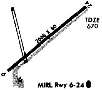
| Runways: | 06/24 |
| Longest Runway: | 06/24 is 2666 ft (813 m) long |
| Runways with an Instrument Approach: |
9G0 Airport Runway Details
| Runway 06/24 | 2666 ft x 60 ft (813 m x 18 m) | |
| Runway Length Source: | 3RD PARTY SURVEY as of 12/04/2016 | |
| Surface: | Asphalt - Good condition - No special surface treatment | |
| Runway Edge Lights: | Medium Intensity | |
Runway Weight Bearing Capacity (in thousands of pounds) |
||
| Single Wheel Landing Gear: | 8.0 | |
Runway 06 |
Runway 24 |
|
Elevation: |
661.8 | 669.5 |
Latitude: |
42-51-34.3127N | 42-51-52.0436N |
Longitude: |
078-43-12.9388W | 078-42-46.4687W |
|
Runway True Alignment: |
048 | 228 |
Glide Path Angle: |
3.0 degrees | 3.0 degrees |
Traffic Pattern: |
Left | Left |
Runway Markings Type: |
Nonprecision Instrument | Nonprecision Instrument |
Runway Markings Condition: |
Fair | Fair |
Object at End: |
ROAD | TREES |
Object Height: |
15 | 19 |
Distance from End: |
202 | 230 |
Object Centerline Offset: |
86 ft. left of centerline | 117 ft. left of centerline |
Visual Glide Slope Indicators: |
2-Light PAPI On Right Side Of Runway | 2-Light PAPI On Left Side Of Runway |
REIL: |
Yes | Yes |
Threshold Crossing Height: |
40 | 28 |
Threshold Elevation: |
662.2 | |
Displaced Threshold: |
68 | |
Threshold Latitude: |
42-51-34.7673N | |
Threshold Longitude: |
078-43-12.2605W |
Services
Airframe Repair: |
Minor |
Powerplant Repair: |
Minor |
Bottled Oxygen: |
None |
Bulk Oxygen: |
None |
Fuel Available: |
100LL, Jet A+ |
Landing Fees: |
Yes |
Parking: |
Hangars available |
Maps & Diagrams
9G0 Sectional
Flight Planning
at skyvector.com
at skyvector.com