Location
Latitude: |
42-29-38.2000N (42.493944) |
Longitude: |
079-16-16.0000W (-79.271111) |
Elevation: |
692.3 feet MSL (211 m MSL) |
Magnetic Variation: |
10.1 W (as of April 2024 from WMM2020 model) |
Time Zone: |
UTC -5.0 (Standard Time) UTC -4.0 (Daylight Savings Time) |
From City: |
03 N.M. E of Dunkirk, New York |
Found On: |
Detroit Chart |
FAA Region: |
AEA |
Contacts
Manager: |
Publicly owned: |
| SHANNON A BARNHART 3163 AIRPORT DR JAMESTOWN, NY 14701 (716) 661-8930 |
CHAUT CO 3163 AIRPORT DR JAMESTOWN, NY 14701 716-484-0204 |
Operations
Airport Status: |
Operational |
Facility Use: |
Public |
Type: |
Airport |
Activation Date: |
11/1943 |
Control tower: |
No |
Attendance (Months/Days/Hours): |
Months/Days/Hours ALL/ALL/0600-1430 |
Boundary ARTCC: |
ZOB (Cleveland) |
Responsible ARTCC: |
ZOB (Cleveland) |
Lighting Schedule: |
SEE RMK |
Segmented Circle Indicator: |
Yes |
Traffic Pattern Altitude (MSL): |
1692 feet (516 m) |
NOTAMs Facility: |
DKK |
NOTAM-D Service: |
Yes |
International Airport of Entry: |
No |
Customs Landing Rights: |
No |
Military Landing Rights: |
Yes |
Civil/Military Joint Use: |
No |
Based Aircraft
| Single Engine: | 24 |
| Multi Engine: | 2 |
| Jet Engine: | 2 |
| GA Helicopters: | 1 |
Annual Operations (as of 09/08/2021)
| Total Operations: | 26005 | |
| Air Taxi: | 1705 | 6.6% |
| GA Local: | 18000 | 69.2% |
| GA Itinerant: | 6000 | 23.1% |
| Military Aircraft: | 300 | 1.2% |
Communications
| CTAF: | 123.075 |
| Unicom: | 123.075 |
| Approach: | BUFFALO 126.5 126.5 |
| Departure: | BUFFALO 126.5 126.5 |
| ASOS: | 119.275 (716-366-7664) |
Fixed Based Operators (FBOs) & Fuel
(Click on a business for detail)
Please help us keep this information up to date. This is a FREE SERVICE just like everything else on Airport Guide! If you see that a business needs to be added, modified, or deleted please fill out our Update Form.
To add, modify, or delete a business click here.
Please help us keep this information up to date. This is a FREE SERVICE just like everything else on Airport Guide! If you see that a business needs to be added, modified, or deleted please fill out our Update Form.
Area Code: 716 |
| Business Name | Frequency | Phone | Fuel Grade |
|---|---|---|---|
| Dunkirk Aviation Sales and Service
Update FBO info |
Unicom 122.8 | 366-6938 | 100LL, Jet A |
| Great Circle Aviation
Update FBO info |
Unicom 122.85 | 366-1409, 800-488-4543 | 100LL, Jet A |
Flight Service Stations
| Primary | Alternate | |
| FSS on Field: | N | |
| FSS Name (ID): | Buffalo(BUF) | |
| Frequency: | ||
| Toll Free Phone: | 1-800-WX-BRIEF |
Instrument Procedures / Charts
FAA Terminal Procedures valid from 0901Z 03/21/24 to 0901Z 04/18/24.
There are various types of charts available for an airport. They are listed in the Page Type column. Here is a legend for those types:
APD - Airport Diagram
DP - Departure Procedure Charts
HOT - Hot Spots
IAP - Instrument Approach Procedure Charts
MIN - Minimums
STAR - Standard Terminal Arrival Charts
| Page Type | Page Name | Volume | Action Since Last Cycle |
|---|---|---|---|
| APD | AIRPORT DIAGRAM | NE-2 | |
| IAP | RNAV (GPS) RWY 15 | NE-2 | |
| IAP | RNAV (GPS) RWY 33 | NE-2 | |
| IAP | RNAV (GPS)-A | NE-2 | Changed |
| IAP | RNAV (GPS)-B | NE-2 | Changed |
| MIN | ALTERNATE MINIMUMS | NE-2 | |
| MIN | TAKEOFF MINIMUMS | NE-2 |
Terminal Procedures are only available for airports in several countries with more being added all the time. If you are looking for a specific country's charts, please send an email to support(at)airportguide.com stating the country name. This will be used to prioritize the implementation.
Navigation Aids (Navaids) near DKK
| Dist (NM) | ID | Morse Code | Name | Type | Freq | True Hdg | Mag Hdg |
|---|---|---|---|---|---|---|---|
| 0.3 | DKK | _ . . _ . _ _ . _ | Dunkirk | DME | 116.2 | 211 | 221 |
| 19.5 | JHW | . _ _ _ . . . . . _ _ | Jamestown | VOR-DME | 114.70 | 160 | 170 |
| 30.4 | GB | _ _ . _ . . . | Plazz | NDB | 204 | 41 | 51 |
| 35.7 | BUF | _ . . . . . _ . . _ . | Buffalo | VOT | 109.00 | 41 | 51 |
| 37.9 | BUF | _ . . . . . _ . . _ . | Buffalo | DME | 116.4 | 46 | 56 |
| 38.7 | ORJ | _ _ _ . _ . . _ _ _ | Corry | NDB | 258 | 205 | 215 |
| 39.2 | SN | St. Catharines | NDB | 408 | 1 | 11 | |
| 39.6 | IAG | . . . _ _ _ . | Niagara Falls | TACAN | 111.00 | 20 | 30 |
| 40.9 | BU | _ . . . . . _ | Klump | NDB | 231 | 41 | 51 |
| 41.5 | IA | . . . _ | Kathi | NDB | 329 | 27 | 37 |
| 43.3 | CQD | _ . _ . _ _ . _ _ . . | Cascade | NDB | 372 | 238 | 248 |
| 43.4 | LYS | . _ . . _ . _ _ . . . | Olean | NDB | 360 | 106 | 116 |
| 45.3 | ZHM | Binbrook | NDB | 266 | 329 | 339 | |
| 47.3 | TDT | _ _ . . _ | Tidioute | DME | 117.6 | 187 | 197 |
| 49.6 | HM | Hamilton | NDB | 221 | 319 | 329 | |
| 51.4 | BFD | _ . . . . . _ . _ . . | Bradford | DME | 116.6 | 145 | 155 |
| 51.5 | ERI | . . _ . . . | Esmer | NDB | 349 | 238 | 248 |
| 53.6 | ERI | . . _ . . . | Erie | TACAN | 109.40 | 238 | 248 |
| 53.8 | ZHA | Ancaster | NDB | 397 | 321 | 331 | |
| 61.2 | FD | Brantford | NDB | 207 | 304 | 314 |
Nearby Airports with Fuel
Notices to Airmen (NOTAMS)
Remarks
| A110-1 | ATNDD HRS ARE SUBJ CHG, CALL AMGR AT 716-581-0062 TO CFM. |
| A110-2 | DEER & BIRDS INVOF AIRPORT |
| A110-3 | DURING WINTER NORMAL ATTENDANCE HOURS SNOW REMOVAL OPERATIONS ARE AVAILABLE; SNOW REMOVAL MAY BE LIMITED ON HOLIDAYS; AIRFIELD RUNWAY/TAXIWAY CONDITIONS NOT MONITORED OUTSIDE OF NORMAL ATTENDANCE HOURS. |
| A110-4 | PPR FOR SVCS OUTSIDE FBO HRS; FBO OPRNG HRS ARE 0800-1700, CALL FBO AT 716-203-6478 DURG AND AFT OPRNG HRS. |
| A110-5 | COLD TEMPERATURE AIRPORT. ALTITUDE CORRECTION REQUIRED AT OR BELOW -22C. |
| A110-6 | FOR CD CTC BUFFALO ATCT AT 716-626-6939/6919. |
| A17 | EXC FEDERAL HOLS. |
| A81-APT | ACTVT HIRL RYS 06/24 & MIRLS 15/33, PAPI RYS 06, 24, 15, & 33, & REIL RY 6 & 24 - CTAF. |
| E111 | EXISTED PRIOR TO 1959. |
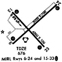
Runways
Runway Summary
| Runways: | 06/24 15/33 |
| Longest Runway: | 06/24 is 6000 ft (1829 m) long |
| Runways with an Instrument Approach: |
DKK Airport Runway Details
| Runway 06/24 | 6000 ft x 100 ft (1829 m x 30 m) | |
| Runway Length Source: | FAA as of 11/14/2014 | |
| Surface: | Asphalt - Excellent condition - Saw-cut or plastic grooved | |
| Runway Edge Lights: | High Intensity | |
Runway Weight Bearing Capacity (in thousands of pounds) |
||
| Single Wheel Landing Gear: | 49.6 | |
| Dual Wheel Landing Gear: | 68.0 | |
| Dual Tandem Wheel Landing Gear: | 130.0 | |
Runway 06 |
Runway 24 |
|
Elevation: |
673.9 | 661.5 |
Latitude: |
42-29-21.8005N | 42-30-00.4508N |
Longitude: |
079-16-41.2459W | 079-15-40.5481W |
|
Runway True Alignment: |
049 | 229 |
Glide Path Angle: |
3.0 degrees | 3.0 degrees |
Traffic Pattern: |
Left | Left |
Runway Markings Type: |
Nonprecision Instrument | Nonprecision Instrument |
Runway Markings Condition: |
Good | Good |
Object at End: |
TREE | |
Object Height: |
56 | |
Distance from End: |
942 | |
Object Centerline Offset: |
324 ft. right of centerline | |
Visual Glide Slope Indicators: |
4-Light PAPI On Left Side Of Runway | 4-Light PAPI On Left Side Of Runway |
REIL: |
Yes | Yes |
Threshold Crossing Height: |
43 | 44 |
| Runway 15/33 | 4000 ft x 100 ft (1219 m x 30 m) | |
| Runway Length Source: | 3RD PARTY SURVEY as of 04/06/2011 | |
| Surface: | Asphalt - Excellent condition - No special surface treatment | |
| Runway Edge Lights: | Medium Intensity | |
Runway Weight Bearing Capacity (in thousands of pounds) |
||
| Single Wheel Landing Gear: | 49.6 | |
| Dual Wheel Landing Gear: | 68.0 | |
| Dual Tandem Wheel Landing Gear: | 130.0 | |
Runway 15 |
Runway 33 |
|
Elevation: |
660.4 | 692.3 |
Latitude: |
42-29-48.7120N | 42-29-18.7625N |
Longitude: |
079-16-40.9364W | 079-16-06.1216W |
|
Runway True Alignment: |
139 | 319 |
Glide Path Angle: |
3.0 degrees | 3.1 degrees |
Traffic Pattern: |
Left | Left |
Runway Markings Type: |
Nonprecision Instrument | Nonprecision Instrument |
Runway Markings Condition: |
Good | Good |
Object at End: |
TREE | TREES |
Object Height: |
56 | 40 |
Distance from End: |
768 | 815 |
Object Centerline Offset: |
324 ft. right of centerline | |
Visual Glide Slope Indicators: |
4-Light PAPI On Left Side Of Runway | 4-Light PAPI On Left Side Of Runway |
Threshold Crossing Height: |
36 | 45 |
Services
Airframe Repair: |
None |
Powerplant Repair: |
None |
Bottled Oxygen: |
None |
Bulk Oxygen: |
None |
Fuel Available: |
100LL, Jet A |
Landing Fees: |
Yes |
Parking: |
Hangars and tiedowns available |
Maps & Diagrams
DKK Sectional
Flight Planning
at skyvector.com
at skyvector.com