Location
Latitude: |
42-56-25.5380N (42.940427) |
Longitude: |
078-43-50.0510W (-78.73057) |
Elevation: |
726.8 feet MSL (222 m MSL) |
Magnetic Variation: |
10.5 W (as of April 2024 from WMM2020 model) |
Time Zone: |
UTC -5.0 (Standard Time) UTC -4.0 (Daylight Savings Time) |
From City: |
05 N.M. E of Buffalo, New York |
Found On: |
Detroit Chart |
FAA Region: |
AEA |
Contacts
Manager: |
Publicly owned: |
| LEON WEITZ 4200 GENESEE ST BUFFALO, NY 14225 (716) 630-6030 |
NIAGARA FRONTIER TRAN AUTH 181 ELLICOTT ST, PO BOX 5008 BUFFALO, NY 14205 716-855-7300 |
Operations
Airport Status: |
Operational |
Facility Use: |
Public |
Type: |
Airport |
Activation Date: |
03/1940 |
Control tower: |
Yes |
Attendance (Months/Days/Hours): |
Months/Days/Hours ALL/ALL/ALL |
Boundary ARTCC: |
ZOB (Cleveland) |
Responsible ARTCC: |
ZOB (Cleveland) |
Segmented Circle Indicator: |
No |
Traffic Pattern Altitude (MSL): |
1727 feet (526 m) |
NOTAMs Facility: |
BUF |
NOTAM-D Service: |
Yes |
International Airport of Entry: |
No |
Customs Landing Rights: |
Yes |
Military Landing Rights: |
Yes |
Civil/Military Joint Use: |
No |
Aircraft Rescue and Firefighting: |
Class I ARFF Index: C Air Carrier Service: Scheduled Certification Date: 05/1973 |
Based Aircraft
| Single Engine: | 12 |
| Multi Engine: | 1 |
| Jet Engine: | 15 |
Annual Operations (as of 12/31/2022)
| Total Operations: | 66584 | |
| Commercial: | 42361 | 63.6% |
| Air Taxi: | 11649 | 17.5% |
| GA Local: | 7576 | 11.4% |
| GA Itinerant: | 4377 | 6.6% |
| Military Aircraft: | 621 | 0.9% |
Communications
| Tower: | BUFFALO 120.5 257.8 Hrs: 24 |
| Clearance Del.: | 257.8 |
| Ground: | 133.2 257.8 |
| Approach: | BUFFALO 126.15 ;053-233 126.5 ;234-052 263.125 ;053-233 317.6 ;234-052 Hrs: 24 |
| Departure: | BUFFALO 126.15 ;053-233 126.5 ;234-052 263.125 ;053-233 317.6 ;234-052 Hrs: 24 |
| ATIS: | 135.35 Hrs: 24 |
| ASOS: | (716-635-0532) |
| EMERG: | 243.0 |
| EMERG: | 121.5 |
| CLASS C: | 126.15 ;053-233 |
| CLASS C: | 263.125 ;053-233 |
| CLASS C: | 126.5 ;234-052 |
| CLASS C: | 317.6 ;234-052 |
Fixed Based Operators (FBOs) & Fuel
(Click on a business for detail)
Please help us keep this information up to date. This is a FREE SERVICE just like everything else on Airport Guide! If you see that a business needs to be added, modified, or deleted please fill out our Update Form.
To add, modify, or delete a business click here.
Please help us keep this information up to date. This is a FREE SERVICE just like everything else on Airport Guide! If you see that a business needs to be added, modified, or deleted please fill out our Update Form.
Area Code: 716 |
| Business Name | Frequency | Phone | Fuel Grade |
|---|---|---|---|
| Prior Aviation Service, Inc.
Update FBO info |
Unicom 122.95 | 633-1000 | 100LL, Mogas, Jet A |
Flight Service Stations
| Primary | Alternate | |
| FSS on Field: | N | |
| FSS Name (ID): | Buffalo(BUF) | |
| Frequency: | ||
| Toll Free Phone: | 1-800-WX-BRIEF |
Instrument Procedures / Charts
FAA Terminal Procedures valid from 0901Z 03/21/24 to 0901Z 04/18/24.
There are various types of charts available for an airport. They are listed in the Page Type column. Here is a legend for those types:
APD - Airport Diagram
DP - Departure Procedure Charts
HOT - Hot Spots
IAP - Instrument Approach Procedure Charts
MIN - Minimums
STAR - Standard Terminal Arrival Charts
| Page Type | Page Name | Volume | Action Since Last Cycle |
|---|---|---|---|
| APD | AIRPORT DIAGRAM | NE-2 | |
| DP | BUFFALO EIGHT | NE-2 | |
| HOT | HOT SPOT | NE-2 | |
| IAP | ILS OR LOC RWY 05 | NE-2 | |
| IAP | ILS OR LOC RWY 23 | NE-2 | |
| IAP | ILS OR LOC RWY 32 | NE-2 | |
| IAP | ILS RWY 23 (SA CAT I) | NE-2 | |
| IAP | RNAV (GPS) RWY 14 | NE-2 | |
| IAP | RNAV (GPS) RWY 32 | NE-2 | |
| IAP | RNAV (GPS) Y RWY 05 | NE-2 | |
| IAP | RNAV (GPS) Y RWY 23 | NE-2 | |
| IAP | RNAV (RNP) Z RWY 05 | NE-2 | |
| IAP | RNAV (RNP) Z RWY 23 | NE-2 | |
| MIN | TAKEOFF MINIMUMS | NE-2 |
Terminal Procedures are only available for airports in several countries with more being added all the time. If you are looking for a specific country's charts, please send an email to support(at)airportguide.com stating the country name. This will be used to prioritize the implementation.
Navigation Aids (Navaids) near BUF
| Dist (NM) | ID | Morse Code | Name | Type | Freq | True Hdg | Mag Hdg |
|---|---|---|---|---|---|---|---|
| 0.2 | BUF | _ . . . . . _ . . _ . | Buffalo | VOT | 109.00 | 245 | 256 |
| 3.8 | BUF | _ . . . . . _ . . _ . | Buffalo | DME | 116.4 | 100 | 111 |
| 5.0 | BU | _ . . . . . _ | Klump | NDB | 231 | 44 | 55 |
| 5.5 | GB | _ _ . _ . . . | Plazz | NDB | 204 | 223 | 233 |
| 11.2 | IA | . . . _ | Kathi | NDB | 329 | 335 | 346 |
| 14.4 | IAG | . . . _ _ _ . | Niagara Falls | TACAN | 111.00 | 315 | 325 |
| 26.1 | SN | St. Catharines | NDB | 408 | 298 | 308 | |
| 36.1 | DKK | _ . . _ . _ _ . _ | Dunkirk | DME | 116.2 | 221 | 231 |
| 42.4 | AVN | . _ . . . _ _ . | Avon | NDB | 344 | 84 | 95 |
| 43.1 | LYS | . _ . . _ . _ _ . . . | Olean | NDB | 360 | 155 | 166 |
| 44.3 | GEE | _ _ . . . | Geneseo | VOR-DME | 108.20 | 97 | 108 |
| 47.6 | ROC | . _ . _ _ _ _ . _ . | Rochester | VOR-DME | 110.00 | 76 | 87 |
| 48.2 | ZHM | Binbrook | NDB | 266 | 285 | 295 | |
| 48.3 | JHW | . _ _ _ . . . . . _ _ | Jamestown | VOR-DME | 114.70 | 201 | 211 |
| 49.5 | TZ | Gibraltar Point | NDB | 257 | 324 | 334 | |
| 50.5 | ITZ | City Centre | DME | 110.15 | 324 | 334 | |
| 54.2 | ZYZ | Queensway | NDB | 368 | 319 | 329 | |
| 57.0 | HM | Hamilton | NDB | 221 | 281 | 291 | |
| 58.2 | IJS | Toronto | DME | 109.10 | 318 | 328 | |
| 58.2 | INV | Toronto | DME | 109.30 | 319 | 329 |
Nearby Airports with Fuel
Notices to Airmen (NOTAMS)
Remarks
| A110-2 | HEAVY CONCENTRATION OF GULLS; BLACKBIRDS & STARLINGS UP TO 5000 FT ON & INVOF ARPT. |
| A110-3 | DEER ON & INVOF ARPT. |
| A110-5 | FOR FBO SVCS CTC 131.75; FOR CARGO SVCS CTC 122.95. |
| A110-6 | TWY A SW RUNUP AREA/HLDG BAY MKD DESIGN GROUP 3 ACFT (GENERALLY B737 A321 OR SMALLER) UNAVBL DESIGN GROUP 4 (INCL BUT NOT LTD TO B757 767). |
| A110-7 | TWY 'K1' CLSD 2100-0800 DAILY. |
| A110-8 | TWY P BTN APCH END RWY 14 AND TWY P2 CLSD TO ACFT WINGSPAN MORE THAN 117 FT. |
| A26 | ARFF INDEX D EQUIPMENT COVERAGE PROVIDED. |
| A57-05 | RWY 05 APCH SLOPE 45:1 TO DSPLCD THLD. |
| A57-14 | RWY 14 APCH SLOPE 29:1 TO DSPLCD THLD. |
| A58-05 | RWY 05 HAS +3 FT POLE LIGHT POLE 59 FT FM RWY END, 497 FT RIGHT. |
| A58-32 | +7 FT OBSTRUCTION LIGHTED FENCE , 0 FT FM RWY END, 480 FT LEFT. |
| E111 | EXISTED PRIOR TO 1959. |
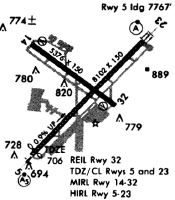
Runways
Runway Summary
| Runways: | 05/23 14/32 |
| Longest Runway: | 05/23 is 8829 ft (2691 m) long |
| Runways with an Instrument Approach: | 05, 23, 32 |
BUF Airport Runway Details
| Runway 05/23 | 8829 ft x 150 ft (2691 m x 46 m) | |
| Runway Length Source: | 3RD PARTY SURVEY as of 09/10/2019 | |
| Surface: | Asphalt - Good condition - Saw-cut or plastic grooved | |
| Runway Pavement Class: | 81 /F/B/W/T | |
| Runway Edge Lights: | High Intensity | |
Runway Weight Bearing Capacity (in thousands of pounds) |
||
| Single Wheel Landing Gear: | 120.0 | |
| Dual Wheel Landing Gear: | 250.0 | |
| Dual Tandem Wheel Landing Gear: | 550.0 | |
| Dual Dual Tandem Wheel Landing Gear: | 1120.0 | |
Runway 05 |
Runway 23 |
|
Elevation: |
674.1 | 726.8 |
Latitude: |
42-55-52.3186N | 42-56-55.1046N |
Longitude: |
078-44-30.0650W | 078-43-07.7076W |
|
Runway True Alignment: |
044 | 224 |
ILS Type: |
ILS | ILS |
Glide Path Angle: |
3.0 degrees | 3.0 degrees |
Traffic Pattern: |
Left | Left |
Runway Markings Type: |
Precision Instrument | Precision Instrument |
Runway Markings Condition: |
Good | Good |
Object at End: |
BLDG | TREE |
Object Height: |
21 | 29 |
Distance from End: |
413 | 1155 |
Object Centerline Offset: |
532 ft. right of centerline | 360 ft. right of centerline |
Visual Glide Slope Indicators: |
4-Light PAPI On Left Side Of Runway | 4-Light PAPI On Right Side Of Runway |
Runway Visual Range (RVR): |
Touchdown, Midfield, Rollout | Touchdown, Midfield, Rollout |
Approach Light System: |
1,400 Foot Medium Intensity Approach Lighting System With Runway Alignment Indicator Lights | Standard 2,400 Foot High Intensity Approach Lighting System With Sequenced Flashers, Cat. II or III Config. |
Touchdown Lights: |
Yes | Yes |
Centerline Lights: |
Yes | Yes |
Threshold Crossing Height: |
49 | 52 |
Threshold Elevation: |
680.6 | 725.9 |
Displaced Threshold: |
535 | 725 |
Threshold Latitude: |
42-55-56.1218N | 42-56-49.9474N |
Threshold Longitude: |
078-44-25.0792W | 078-43-14.4740W |
Declared Distances |
||
Take Off Run Avbl. (TORA): |
8829 | 8829 |
Take Off Distance Avbl. (TODA): |
8829 | 8829 |
Actual Stop Dist. Avbl. (ASDA): |
8104 | 8294 |
Landing Dist. Avbl. (LDA): |
7569 | 7569 |
| Runway 14/32 | 7161 ft x 150 ft (2183 m x 46 m) | |
| Runway Length Source: | 3RD PARTY SURVEY as of 09/10/2019 | |
| Surface: | Asphalt - Good condition - Saw-cut or plastic grooved | |
| Runway Pavement Class: | 70 /F/B/W/T | |
| Runway Edge Lights: | High Intensity | |
Runway Weight Bearing Capacity (in thousands of pounds) |
||
| Single Wheel Landing Gear: | 120.0 | |
| Dual Wheel Landing Gear: | 250.0 | |
| Dual Tandem Wheel Landing Gear: | 489.0 | |
| Dual Dual Tandem Wheel Landing Gear: | 1016.0 | |
Runway 14 |
Runway 32 |
|
Elevation: |
699.1 | 708.8 |
Latitude: |
42-56-48.9024N | 42-56-06.6676N |
Longitude: |
078-44-30.0966W | 078-43-12.8701W |
|
Runway True Alignment: |
127 | 307 |
ILS Type: |
ILS/DME | |
Glide Path Angle: |
3.0 degrees | 3.0 degrees |
Traffic Pattern: |
Left | Left |
Runway Markings Type: |
Nonprecision Instrument | Precision Instrument |
Runway Markings Condition: |
Good | Good |
Object at End: |
TREE | SIGN |
Object Height: |
31 | 14 |
Distance from End: |
608 | 200 |
Object Centerline Offset: |
532 ft. right of centerline | 360 ft. right of centerline |
Visual Glide Slope Indicators: |
4-Light PAPI On Left Side Of Runway | 4-Light PAPI On Left Side Of Runway |
Approach Light System: |
1,400 Foot Medium Intensity Approach Lighting System With Runway Alignment Indicator Lights | |
REIL: |
Yes | No |
Threshold Crossing Height: |
53 | 54 |
Threshold Elevation: |
700.3 | 708.0 |
Displaced Threshold: |
320 | 720 |
Threshold Latitude: |
42-56-47.0156N | 42-56-10.9149N |
Threshold Longitude: |
078-44-26.6457W | 078-43-20.6342W |
Declared Distances |
||
Take Off Run Avbl. (TORA): |
7161 | 7161 |
Take Off Distance Avbl. (TODA): |
7161 | 7161 |
Actual Stop Dist. Avbl. (ASDA): |
6441 | 6841 |
Landing Dist. Avbl. (LDA): |
6121 | 6121 |
Services
Airframe Repair: |
Minor |
Powerplant Repair: |
Minor |
Fuel Available: |
Mogas |
Maps & Diagrams
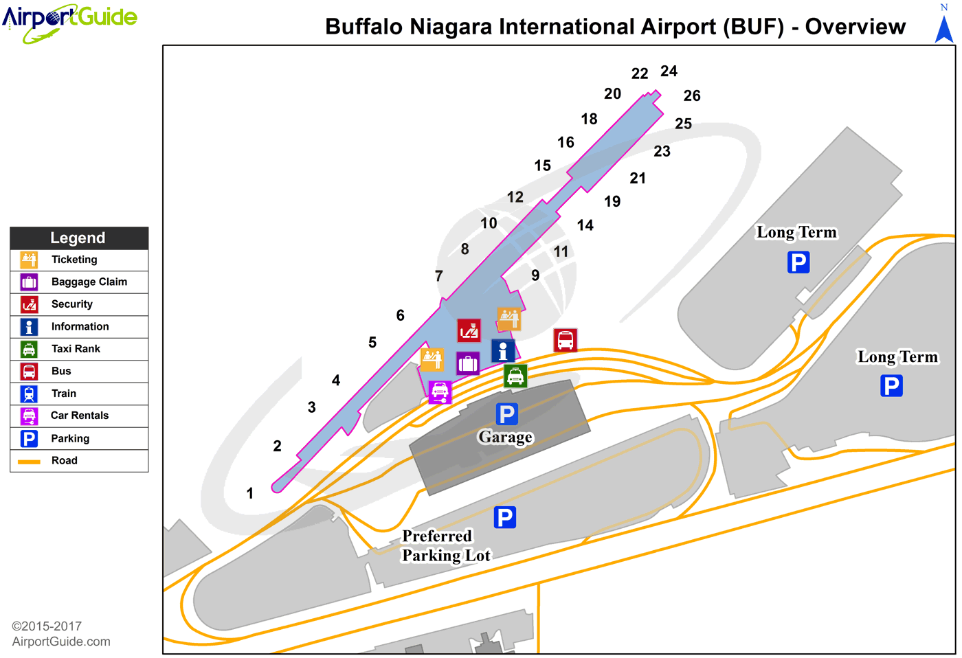
BUF Sectional
Flight Planning
at skyvector.com
at skyvector.com