Location
Latitude: |
34-28-40.9000N (34.478028) |
Longitude: |
093-05-46.4000W (-93.096222) |
Elevation: |
540.3 feet MSL (165 m MSL) |
Magnetic Variation: |
0.3 E (as of April 2024 from WMM2020 model) |
Time Zone: |
UTC -6.0 (Standard Time) UTC -5.0 (Daylight Savings Time) |
From City: |
03 N.M. SW of Hot Springs, Arkansas |
Found On: |
Memphis Chart |
FAA Region: |
ASW |
Contacts
Manager: |
Publicly owned: |
| DON ROWLETT 525 AIRPORT ROAD HOT SPRINGS, AR 71913 501-321-6750 |
CITY OF HOT SPRINGS PO BOX 700 HOT SPRINGS, AR 71902 501-321-6810 |
Operations
Airport Status: |
Operational |
Facility Use: |
Public |
Type: |
Airport |
Activation Date: |
04/1940 |
Control tower: |
No |
Attendance (Months/Days/Hours): |
Months/Days/Hours ALL/ALL/0500-2200 |
Boundary ARTCC: |
ZME (Memphis) |
Responsible ARTCC: |
ZME (Memphis) |
Lighting Schedule: |
SEE RMK |
Segmented Circle Indicator: |
Yes |
Traffic Pattern Altitude (MSL): |
1540 feet (469 m) |
NOTAMs Facility: |
HOT |
NOTAM-D Service: |
Yes |
International Airport of Entry: |
No |
Customs Landing Rights: |
No |
Military Landing Rights: |
Yes |
Civil/Military Joint Use: |
No |
Aircraft Rescue and Firefighting: |
Class II ARFF Index: A Air Carrier Service: Scheduled Certification Date: 05/1973 |
Based Aircraft
| Single Engine: | 56 |
| Multi Engine: | 10 |
| Jet Engine: | 4 |
| GA Helicopters: | 2 |
Annual Operations (as of 06/30/2023)
| Total Operations: | 35100 | |
| Air Taxi: | 1900 | 5.4% |
| GA Local: | 6200 | 17.7% |
| GA Itinerant: | 26000 | 74.1% |
| Military Aircraft: | 1000 | 2.8% |
Communications
| CTAF: | 123.000 |
| Unicom: | 123.000 |
| ASOS: | 119.925 (501-624-7633) |
- APCH/DEP SVC PRVDD BY MEMPHIS ARTCC ON FREQS 128.475/377.15 (HOT SPRINGS RCAG).
Fixed Based Operators (FBOs) & Fuel
(Click on a business for detail)
Please help us keep this information up to date. This is a FREE SERVICE just like everything else on Airport Guide! If you see that a business needs to be added, modified, or deleted please fill out our Update Form.
To add, modify, or delete a business click here.
Please help us keep this information up to date. This is a FREE SERVICE just like everything else on Airport Guide! If you see that a business needs to be added, modified, or deleted please fill out our Update Form.
Area Code: 501 |
| Business Name | Frequency | Phone | Fuel Grade |
|---|---|---|---|
| City of Hot Springs
Update FBO info |
Unicom 123.0 | 624-3306 | 100LL, Jet A |
Flight Service Stations
| Primary | Alternate | |
| FSS on Field: | N | |
| FSS Name (ID): | Jonesboro(JBR) | |
| Frequency: | ||
| Toll Free Phone: | 1-800-WX-BRIEF |
Instrument Procedures / Charts
FAA Terminal Procedures valid from 0901Z 03/21/24 to 0901Z 04/18/24.
There are various types of charts available for an airport. They are listed in the Page Type column. Here is a legend for those types:
APD - Airport Diagram
DP - Departure Procedure Charts
HOT - Hot Spots
IAP - Instrument Approach Procedure Charts
MIN - Minimums
STAR - Standard Terminal Arrival Charts
| Page Type | Page Name | Volume | Action Since Last Cycle |
|---|---|---|---|
| IAP | ILS OR LOC RWY 05 | SC-1 | |
| IAP | RNAV (GPS) RWY 05 | SC-1 | |
| IAP | VOR RWY 05 | SC-1 | |
| MIN | ALTERNATE MINIMUMS | SC-1 | |
| MIN | TAKEOFF MINIMUMS | SC-1 |
Terminal Procedures are only available for airports in several countries with more being added all the time. If you are looking for a specific country's charts, please send an email to support(at)airportguide.com stating the country name. This will be used to prioritize the implementation.
Navigation Aids (Navaids) near HOT
| Dist (NM) | ID | Morse Code | Name | Type | Freq | True Hdg | Mag Hdg |
|---|---|---|---|---|---|---|---|
| 0.3 | HOT | . . . . _ _ _ _ | Hot Springs | VOR-DME | 110.00 | 82 | 82 |
| 5.7 | HO | . . . . _ _ _ | Hossy | NDB | 385 | 234 | 234 |
| 25.3 | ADF | . _ _ . . . . _ . | Arkadelphia | NDB | 275 | 181 | 181 |
| 39.4 | MPJ | _ _ . _ _ . . _ _ _ | Morrilton | NDB | 410 | 12 | 12 |
| 40.7 | LI | . _ . . . . | Lasky | NDB | 353 | 73 | 73 |
| 46.7 | RUE | . _ . . . _ . | Russellville | NDB | 379 | 0 | 360 |
| 46.8 | LIT | . _ . . . . _ | Little Rock | VORTAC | 113.90 | 74 | 74 |
| 48.4 | VM | . . . _ _ _ | Fench | NDB | 352 | 274 | 273 |
| 49.1 | CWS | _ . _ . . _ _ . . . | Conway | NDB | 302 | 42 | 42 |
| 53.3 | HPC | . . . . . _ _ . _ . _ . | Hope | NDB | 362 | 211 | 211 |
| 53.3 | LRF | . _ . . . _ . . . _ . | Jacksonville | TACAN | 109.20 | 60 | 60 |
| 59.6 | PBF | . _ _ . _ . . . . . _ . | Pine Bluff | VOR-DME | 116.00 | 103 | 103 |
| 60.3 | TYV | _ _ . _ _ . . . _ | Toneyville | NDB | 290 | 61 | 61 |
| 61.6 | CZE | _ . _ . _ _ . . . | Clarksville | NDB | 201 | 344 | 344 |
| 70.0 | TX | _ _ . . _ | Tecco | NDB | 234 | 215 | 214 |
| 73.8 | EL | . . _ . . | Lados | NDB | 418 | 165 | 165 |
| 74.9 | TT | _ _ | Stutt | NDB | 338 | 88 | 88 |
| 75.2 | SGT | . . . _ _ . _ | Stuttgart | NDB | 269 | 81 | 81 |
| 75.4 | ELD | . . _ . . _ . . | El Dorado | VOR-DME | 115.50 | 166 | 166 |
| 75.6 | TXK | _ _ . . _ _ . _ | Texarkana | VORTAC | 116.30 | 220 | 219 |
Nearby Airports with Fuel
Notices to Airmen (NOTAMS)
Remarks
| A110-1 | FOR CD CTC MEMPHIS ARTCC AT 901-368-8453. |
| A43-23 | RWY 23 PAPI UNUSBL BYD 6 DEGS RIGHT OF CNTRLN. |
| A70-FUEL-10 | 0LL FOR FUEL AFT HRS CALL 501-617-0324 OR 501-609-6523. |
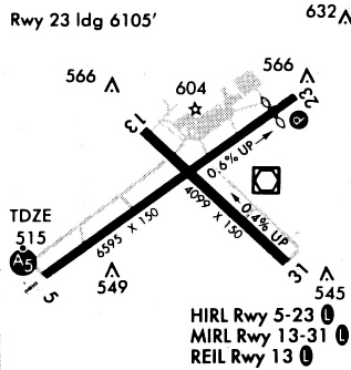
| A81-APT | ACTVT HIRL RY 05/23; MIRL RY 13/31; MALSR RY 05; PAPI RY 23 & REIL RY 13 - CTAF. |
Runways
Runway Summary
| Runways: | 05/23 13/31 |
| Longest Runway: | 05/23 is 6595 ft (2010 m) long |
| Runways with an Instrument Approach: | 05 |
HOT Airport Runway Details
| Runway 05/23 | 6595 ft x 150 ft (2010 m x 46 m) | |
| Runway Length Source: | 3RD PARTY SURVEY as of 07/11/2012 | |
| Surface: | Asphalt - Good condition - Saw-cut or plastic grooved | |
| Runway Pavement Class: | 54 /F/D/X/U | |
| Runway Edge Lights: | High Intensity | |
Runway Weight Bearing Capacity (in thousands of pounds) |
||
| Single Wheel Landing Gear: | 75.0 | |
| Dual Wheel Landing Gear: | 125.0 | |
| Dual Tandem Wheel Landing Gear: | 210.0 | |
| Dual Dual Tandem Wheel Landing Gear: | 400.0 | |
Runway 05 |
Runway 23 |
|
Elevation: |
501.6 | 540.3 |
Latitude: |
34-28-22.8751N | 34-29-00.9685N |
Longitude: |
093-06-22.5491W | 093-05-18.6033W |
|
Runway True Alignment: |
054 | 234 |
ILS Type: |
ILS/DME | |
Glide Path Angle: |
0.0 degrees | 3.0 degrees |
Traffic Pattern: |
Right | Left |
Runway Markings Type: |
Precision Instrument | Nonprecision Instrument |
Runway Markings Condition: |
Good | Good |
Object at End: |
POLE | |
Object Height: |
78 | |
Object Marked/Lighted?: |
Lighted | |
Distance from End: |
1800 | |
Object Centerline Offset: |
650 ft. right of centerline | |
Visual Glide Slope Indicators: |
4-Light PAPI On Left Side Of Runway | |
Approach Light System: |
1,400 Foot Medium Intensity Approach Lighting System With Runway Alignment Indicator Lights | |
Threshold Crossing Height: |
40 | |
Declared Distances |
||
Take Off Run Avbl. (TORA): |
6595 | 6595 |
Take Off Distance Avbl. (TODA): |
6595 | 6595 |
Actual Stop Dist. Avbl. (ASDA): |
6595 | 6235 |
Landing Dist. Avbl. (LDA): |
6595 | 6235 |
| Runway 13/31 | 4098 ft x 100 ft (1249 m x 30 m) | |
| Runway Length Source: | 3RD PARTY SURVEY as of 07/11/2012 | |
| Surface: | Asphalt - Good condition - No special surface treatment | |
| Runway Pavement Class: | 25 /F/D/Y/T | |
| Runway Edge Lights: | Medium Intensity | |
Runway Weight Bearing Capacity (in thousands of pounds) |
||
| Single Wheel Landing Gear: | 28.0 | |
| Dual Wheel Landing Gear: | 36.0 | |
| Dual Tandem Wheel Landing Gear: | 63.0 | |
Runway 13 |
Runway 31 |
|
Elevation: |
519.8 | 505.3 |
Latitude: |
34-28-53.3295N | 34-28-25.0420N |
Longitude: |
093-05-57.3190W | 093-05-22.2665W |
|
Runway True Alignment: |
134 | 314 |
Glide Path Angle: |
0.0 degrees | 0.0 degrees |
Traffic Pattern: |
Right | Left |
Runway Markings Type: |
Basic | Basic |
Runway Markings Condition: |
Good | Good |
Object at End: |
TREES | POLE |
Object Height: |
40 | 121 |
Object Marked/Lighted?: |
Lighted | |
Distance from End: |
600 | 3200 |
Object Centerline Offset: |
650 ft. right of centerline | |
REIL: |
Yes | |
Declared Distances |
||
Take Off Run Avbl. (TORA): |
3210 | 4098 |
Take Off Distance Avbl. (TODA): |
4098 | 4098 |
Actual Stop Dist. Avbl. (ASDA): |
4098 | 4098 |
Landing Dist. Avbl. (LDA): |
4098 | 3210 |
Services
Airframe Repair: |
None |
Powerplant Repair: |
None |
Bulk Oxygen: |
None |
Fuel Available: |
100LL, Jet A |
Landing Fees: |
No |
Parking: |
Tiedowns available |
Maps & Diagrams
HOT Sectional
Flight Planning
at skyvector.com
at skyvector.com