Location
Latitude: |
36-13-31.3950N (36.225388) |
Longitude: |
095-19-48.2050W (-95.330057) |
Elevation: |
622.4 feet MSL (190 m MSL) |
Magnetic Variation: |
1.8 E (as of April 2024 from WMM2020 model) |
Time Zone: |
UTC -6.0 (Standard Time) UTC -5.0 (Daylight Savings Time) |
From City: |
06 N.M. S of Pryor, Oklahoma |
Found On: |
Kansas City Chart |
FAA Region: |
ASW |
Contacts
Manager: |
Publicly owned: |
| JASON STUTZMAN PO BOX 945 PRYOR CREEK, OK 74362 918-825-3500 |
OK ORDNANCE WORKS AUTH PO BOX 945 PRYOR, OK 74362 918-825-3500 |
Operations
Airport Status: |
Operational |
Facility Use: |
Public |
Type: |
Airport |
Activation Date: |
01/1964 |
Control tower: |
No |
Attendance (Months/Days/Hours): |
Months/Days/Hours ALL/MON-FRI/0800-1700 |
Boundary ARTCC: |
ZME (Memphis) |
Responsible ARTCC: |
ZKC (Kansas City) |
Lighting Schedule: |
SEE RMK |
Segmented Circle Indicator: |
Yes |
Traffic Pattern Altitude (MSL): |
1622 feet (494 m) |
NOTAMs Facility: |
MLC |
NOTAM-D Service: |
Yes |
International Airport of Entry: |
No |
Customs Landing Rights: |
No |
Military Landing Rights: |
Yes |
Civil/Military Joint Use: |
No |
Based Aircraft
| Single Engine: | 11 |
| GA Helicopters: | 1 |
| Gliders: | 4 |
Annual Operations (as of 10/13/2016)
| Total Operations: | 5125 | |
| GA Local: | 2500 | 48.8% |
| GA Itinerant: | 2500 | 48.8% |
| Military Aircraft: | 125 | 2.4% |
Communications
| CTAF: | 122.800 |
| Unicom: | 122.800 |
| Approach: | TULSA 119.1 119.1 |
| Departure: | TULSA 119.1 119.1 |
| AWOS-3PT: | 120.1 (918-476-0517) |
Fixed Based Operators (FBOs) & Fuel
(Click on a business for detail)
Please help us keep this information up to date. This is a FREE SERVICE just like everything else on Airport Guide! If you see that a business needs to be added, modified, or deleted please fill out our Update Form.
To add, modify, or delete a business click here.
Please help us keep this information up to date. This is a FREE SERVICE just like everything else on Airport Guide! If you see that a business needs to be added, modified, or deleted please fill out our Update Form.
Area Code: 918 |
| Business Name | Frequency | Phone | Fuel Grade |
|---|---|---|---|
| Mid America Aviation
Update FBO info |
Unicom 122.8 | 476-6090 | 100LL |
Flight Service Stations
| Primary | Alternate | |
| FSS on Field: | N | |
| FSS Name (ID): | Mc Alester(MLC) | |
| Frequency: | ||
| Toll Free Phone: | 1-800-WX-BRIEF |
Instrument Procedures / Charts
FAA Terminal Procedures valid from 0901Z 03/21/24 to 0901Z 04/18/24.
There are various types of charts available for an airport. They are listed in the Page Type column. Here is a legend for those types:
APD - Airport Diagram
DP - Departure Procedure Charts
HOT - Hot Spots
IAP - Instrument Approach Procedure Charts
MIN - Minimums
STAR - Standard Terminal Arrival Charts
| Page Type | Page Name | Volume | Action Since Last Cycle |
|---|---|---|---|
| IAP | RNAV (GPS) RWY 18 | SC-1 | |
| IAP | RNAV (GPS) RWY 36 | SC-1 | |
| MIN | ALTERNATE MINIMUMS | SC-1 | |
| MIN | TAKEOFF MINIMUMS | SC-1 |
Terminal Procedures are only available for airports in several countries with more being added all the time. If you are looking for a specific country's charts, please send an email to support(at)airportguide.com stating the country name. This will be used to prioritize the implementation.
Navigation Aids (Navaids) near H71
| Dist (NM) | ID | Morse Code | Name | Type | Freq | True Hdg | Mag Hdg |
|---|---|---|---|---|---|---|---|
| 22.2 | TUL | _ . . _ . _ . . | Tulsa | VORTAC | 114.40 | 265 | 263 |
| 23.8 | TQH | _ _ _ . _ . . . . | Tahlequah | NDB | 215 | 138 | 136 |
| 26.8 | TUL | _ . . _ . _ . . | Tulsa Intl | VOT | 109.00 | 266 | 264 |
| 28.1 | TU | _ . . _ | Oillr | NDB | 338 | 254 | 252 |
| 36.0 | GNP | _ _ . _ . . _ _ . | Glenpool | DME | 110.6 | 239 | 237 |
| 40.0 | OWP | _ _ _ . _ _ . _ _ . | William Pogue | NDB | 362 | 265 | 263 |
| 40.8 | SLG | . . . . _ . . _ _ . | Siloam Springs | NDB | 284 | 92 | 91 |
| 41.2 | OKM | _ _ _ _ . _ _ _ | Okmulgee | VOR-DME | 114.90 | 219 | 217 |
| 41.2 | OK | _ _ _ _ . _ | Preso | NDB | 388 | 226 | 224 |
| 49.4 | BVO | _ . . . . . . _ _ _ _ | Bartlesville | VOR-DME | 117.90 | 317 | 315 |
| 49.5 | BV | _ . . . . . . _ | Dewie | NDB | 201 | 318 | 316 |
| 53.3 | CFV | _ . _ . . . _ . . . . _ | Coffeyville | NDB | 212 | 347 | 345 |
| 56.0 | DAK | _ . . . _ _ . _ | Drake | DME | 115.25 | 100 | 99 |
| 56.0 | IQS | . . _ _ . _ . . . | Sallisaw | NDB | 520 | 152 | 150 |
| 56.3 | OSW | _ _ _ . . . . _ _ | Oswego | DME | 117.6 | 6 | 4 |
| 56.8 | EOS | . _ _ _ . . . | Neosho | DME | 117.3 | 49 | 48 |
| 58.5 | RZC | . _ . _ _ . . _ . _ . | Razorback | VORTAC | 116.40 | 88 | 87 |
| 59.4 | HET | . . . . . _ | Henryetta | NDB | 267 | 214 | 212 |
| 62.5 | RO | . _ . _ _ _ | Rogrs | NDB | 263 | 76 | 75 |
| 68.3 | GK | _ _ . _ . _ | Jembo | NDB | 311 | 142 | 141 |
Nearby Airports with Fuel
Notices to Airmen (NOTAMS)
Remarks
| A110-1 | WKEND GLDR OPS ON & INVOF ARPT. |
| A110-2 | FOR CD CTC TULSA APCH AT 918-831-6714. |
| A17 | AFT HR SVC - 918-855-6464 OR 918-636-0238. |
| A43-18 | UNUSBL BYD 9 DEGS RIGHT OF CNTRLN. |
| A70-FUEL-10 | 0LL AVBL H24 WITH CREDIT CARD. |
| A81-APT | ACTVT REIL RWY 18 & 36; MIRL RWY 18/36 - CTAF. |
Runways
Runway Summary
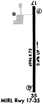
| Runways: | 18/36 |
| Longest Runway: | 18/36 is 5001 ft (1524 m) long |
| Runways with an Instrument Approach: |
H71 Airport Runway Details
| Runway 18/36 | 5001 ft x 72 ft (1524 m x 22 m) | |
| Runway Length Source: | ADO as of 05/16/2022 | |
| Surface: | Asphalt - Good condition - No special surface treatment | |
| Runway Edge Lights: | Medium Intensity | |
Runway Weight Bearing Capacity (in thousands of pounds) |
||
| Single Wheel Landing Gear: | 30.0 | |
Runway 18 |
Runway 36 |
|
Elevation: |
621.4 | 603.1 |
Latitude: |
36-13-56.1197N | 36-13-06.6700N |
Longitude: |
095-19-48.2008W | 095-19-48.2100W |
|
Runway True Alignment: |
180 | 000 |
Glide Path Angle: |
3.0 degrees | 3.0 degrees |
Traffic Pattern: |
Right | Left |
Runway Markings Type: |
Nonprecision Instrument | Nonprecision Instrument |
Runway Markings Condition: |
Good | Good |
Visual Glide Slope Indicators: |
4-Light PAPI On Left Side Of Runway | 4-Light PAPI On Left Side Of Runway |
REIL: |
Yes | Yes |
Threshold Crossing Height: |
40 | 40 |
Services
Airframe Repair: |
Major |
Powerplant Repair: |
Major |
Bottled Oxygen: |
High Pressure |
Bulk Oxygen: |
None |
Fuel Available: |
100LL, Jet A |
Landing Fees: |
No |
Parking: |
Hangars and tiedowns available |
Maps & Diagrams
H71 Sectional
Flight Planning
at skyvector.com
at skyvector.com