Location
Latitude: |
44-12-12.5610N (44.203489) |
Longitude: |
072-33-43.5470W (-72.562096) |
Elevation: |
1165.6 feet MSL (355 m MSL) |
Magnetic Variation: |
13.9 W (as of April 2024 from WMM2020 model) |
Time Zone: |
UTC -5.0 (Standard Time) UTC -4.0 (Daylight Savings Time) |
From City: |
03 N.M. W of Barre/Montpelier, Vermont |
Found On: |
Montreal Chart |
FAA Region: |
ANE |
Contacts
Manager: |
Publicly owned: |
| ROLLIN TEBBETTS 219 N MAIN ST BARRE, VT 05641 802-585-5586 |
STATE OF VERMONT 219 N MAIN ST BARRE, VT 05641 802-279-2647 |
Operations
Airport Status: |
Operational |
Facility Use: |
Public |
Type: |
Airport |
Activation Date: |
08/1937 |
Control tower: |
No |
Attendance (Months/Days/Hours): |
Months/Days/Hours ALL/ALL/0800-1700 |
Boundary ARTCC: |
ZBW (Boston) |
Responsible ARTCC: |
ZBW (Boston) |
Lighting Schedule: |
SEE RMK |
Segmented Circle Indicator: |
Yes |
Traffic Pattern Altitude (MSL): |
2166 feet (660 m) |
NOTAMs Facility: |
MPV |
NOTAM-D Service: |
Yes |
International Airport of Entry: |
No |
Customs Landing Rights: |
No |
Military Landing Rights: |
Yes |
Civil/Military Joint Use: |
No |
Based Aircraft
| Single Engine: | 37 |
| Multi Engine: | 3 |
| Jet Engine: | 1 |
| GA Helicopters: | 1 |
Annual Operations (as of 06/30/2019)
| Total Operations: | 10300 | |
| Air Taxi: | 300 | 2.9% |
| GA Local: | 8000 | 77.7% |
| GA Itinerant: | 1500 | 14.6% |
| Military Aircraft: | 500 | 4.9% |
Communications
| CTAF: | 122.800 |
| Unicom: | 122.800 |
| ASOS: | 132.675 (802-229-2037) |
- APCH/DEP SVC PRVDD BY BOSTON ARTCC ON FREQS 135.7/282.2 (MONTPELIER RCAG).
Fixed Based Operators (FBOs) & Fuel
(Click on a business for detail)
Please help us keep this information up to date. This is a FREE SERVICE just like everything else on Airport Guide! If you see that a business needs to be added, modified, or deleted please fill out our Update Form.
To add, modify, or delete a business click here.
Please help us keep this information up to date. This is a FREE SERVICE just like everything else on Airport Guide! If you see that a business needs to be added, modified, or deleted please fill out our Update Form.
Area Code: 802 |
| Business Name | Frequency | Phone | Fuel Grade |
|---|---|---|---|
| Vermont Flying Services, Inc.
Update FBO info |
Unicom 122.8 | 223-2221 | 100LL |
Flight Service Stations
| Primary | Alternate | |
| FSS on Field: | N | |
| FSS Name (ID): | Burlington(BTV) | |
| Frequency: | ||
| Toll Free Phone: | 1-800-WX-BRIEF |
Instrument Procedures / Charts
FAA Terminal Procedures valid from 0901Z 03/21/24 to 0901Z 04/18/24.
There are various types of charts available for an airport. They are listed in the Page Type column. Here is a legend for those types:
APD - Airport Diagram
DP - Departure Procedure Charts
HOT - Hot Spots
IAP - Instrument Approach Procedure Charts
MIN - Minimums
STAR - Standard Terminal Arrival Charts
| Page Type | Page Name | Volume | Action Since Last Cycle |
|---|---|---|---|
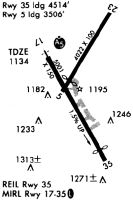
| IAP | ILS OR LOC RWY 17 | NE-1 | Changed |
| IAP | RNAV (GPS) RWY 17 | NE-1 | |
| IAP | RNAV (GPS) RWY 35 | NE-1 | |
| MIN | ALTERNATE MINIMUMS | NE-1 | |
| MIN | TAKEOFF MINIMUMS | NE-1 |
Terminal Procedures are only available for airports in several countries with more being added all the time. If you are looking for a specific country's charts, please send an email to support(at)airportguide.com stating the country name. This will be used to prioritize the implementation.
Navigation Aids (Navaids) near MPV
| Dist (NM) | ID | Morse Code | Name | Type | Freq | True Hdg | Mag Hdg |
|---|---|---|---|---|---|---|---|
| 8.6 | MPV | _ _ . _ _ . . . . _ | Montpelier | VOR-DME | 116.90 | 145 | 159 |
| 29.1 | BTV | _ . . . _ . . . _ | Burlington | VOR-DME | 117.50 | 293 | 307 |
| 29.1 | LLX | . _ . . . _ . . _ . . _ | Lyndonville | NDB | 353 | 51 | 65 |
| 30.1 | BTV | _ . . . _ . . . _ | Burlington | VOT | 109.00 | 302 | 316 |
| 30.3 | BJA | _ . . . . _ _ _ . _ | Burlington | TACAN | 112.40 | 302 | 316 |
| 34.4 | LAH | . _ . . . _ . . . . | Hanover | NDB | 276 | 150 | 164 |
| 34.4 | DYO | _ . . _ . _ _ _ _ _ | Smuto | NDB | 221 | 209 | 223 |
| 34.8 | LEB | . _ . . . _ . . . | Lebanon | DME | 113.7 | 154 | 168 |
| 35.5 | BT | _ . . . _ | Herro | NDB | 382 | 304 | 318 |
| 38.0 | R | . _ . | Chitt | FAN MARKER | 206 | 220 | |
| 38.8 | GMA | _ _ . _ _ . _ | Mahn | NDB | 386 | 75 | 89 |
| 38.8 | IVV | . . . . . _ . . . _ | White River | NDB | 379 | 173 | 187 |
| 43.9 | RUT | . _ . . . _ _ | Rutland | DME | 111 | 202 | 216 |
| 44.0 | HIE | . . . . . . . | Witey | FAN MARKER | 76 | 90 | |
| 50.3 | PLB | . _ _ . . _ . . _ . . . | Plattsburgh | VORTAC | 116.90 | 305 | 319 |
| 50.7 | CNH | _ . _ . _ . . . . . | Claremont | NDB | 233 | 170 | 184 |
| 56.0 | SXD | . . . _ . . _ _ . . | Springfield | NDB | 265 | 181 | 195 |
| 59.7 | LC | . _ . . _ . _ . | Blnap | NDB | 328 | 131 | 145 |
| 61.7 | LCI | . _ . . _ . _ . . . | Laconia | FAN MARKER | 127 | 141 | |
| 64.4 | BML | _ . . . _ _ . _ . . | Berlin | DME | 116.55 | 65 | 79 |
Nearby Airports with Fuel
Notices to Airmen (NOTAMS)
Remarks
| A110-2 | FLD COND RPRT MAY NOT BE AVBL AND/OR CURRENT AT NGT. |
| A110-3 | RWY CONDS MAY NOT BE MNT OR RPRTD WHEN ARPT IS UNATNDD. |
| A110-4 | 70 FT TREE, 391 FT RIGHT OF CNTRLN, 1545 FT FM RWY 35 END. |
| A110-5 | 50 FT TREE, 332 FT LEFT OF CNTRLN, 393 FT FM RWY 17 END. |
| A110-6 | COLD TEMPERATURE AIRPORT. ALTITUDE CORRECTION REQUIRED AT OR BELOW -20C. |
| A110-7 | FOR CD IF UNA TO CTC ON FSS FREQ, CTC BOSTON ARTCC AT 603-879-6859 . |
| A81-APT | ACTVT MALSR RWY 17; MIRL RWY 17/35 - CTAF. |
| A82 | UNICOM BASE STN NOT MANNED CONSLY. |
| E111 | EXISTED PRIOR TO 1959 |
Runways
Runway Summary
| Runways: | 05/23 17/35 |
| Longest Runway: | 17/35 is 5000 ft (1524 m) long |
| Runways with an Instrument Approach: | 17 |
MPV Airport Runway Details
| Runway 05/23 | 3001 ft x 75 ft (915 m x 23 m) | |
| Runway Length Source: | 3RD PARTY SURVEY as of 01/17/2019 | |
| Surface: | Asphalt - Excellent condition - No special surface treatment | |
| Runway Edge Lights: | Medium Intensity | |
Runway Weight Bearing Capacity (in thousands of pounds) |
||
| Single Wheel Landing Gear: | 30.0 | |
| Dual Wheel Landing Gear: | 46.0 | |
Runway 05 |
Runway 23 |
|
Elevation: |
1115.5 | 1084.7 |
Latitude: |
44-12-17.4984N | 44-12-42.5180N |
Longitude: |
072-33-47.6004W | 072-33-25.5400W |
|
Runway True Alignment: |
032 | 212 |
Glide Path Angle: |
0.0 degrees | 0.0 degrees |
Traffic Pattern: |
Left | Left |
Runway Markings Type: |
Basic | Basic |
Runway Markings Condition: |
Good | Good |
Object at End: |
TREES | |
Object Height: |
75 | |
Distance from End: |
1241 | |
Object Centerline Offset: |
279 ft. left of centerline | |
REIL: |
No | No |
Touchdown Lights: |
No | No |
Centerline Lights: |
No | No |
| Runway 17/35 | 5000 ft x 100 ft (1524 m x 30 m) | |
| Runway Length Source: | 3RD PARTY SURVEY as of 01/17/2019 | |
| Surface: | Asphalt - Excellent condition - No special surface treatment | |
| Runway Edge Lights: | Medium Intensity | |
Runway Weight Bearing Capacity (in thousands of pounds) |
||
| Single Wheel Landing Gear: | 31.0 | |
| Dual Wheel Landing Gear: | 70.0 | |
Runway 17 |
Runway 35 |
|
Elevation: |
1091.5 | 1165.6 |
Latitude: |
44-12-23.8213N | 44-11-40.3598N |
Longitude: |
072-34-04.0130W | 072-33-31.4558W |
|
Runway True Alignment: |
152 | 332 |
ILS Type: |
ILS/DME | |
Glide Path Angle: |
3.0 degrees | 0.0 degrees |
Traffic Pattern: |
Left | Left |
Runway Markings Type: |
Precision Instrument | Nonprecision Instrument |
Runway Markings Condition: |
Good | Good |
Object at End: |
TREES | TREES |
Object Height: |
38 | 81 |
Distance from End: |
664 | 1335 |
Object Centerline Offset: |
279 ft. left of centerline | |
Visual Glide Slope Indicators: |
4-Light PAPI On Left Side Of Runway | |
Approach Light System: |
1,400 Foot Medium Intensity Approach Lighting System With Runway Alignment Indicator Lights | |
REIL: |
No | Yes |
Touchdown Lights: |
No | No |
Centerline Lights: |
No | No |
Threshold Crossing Height: |
46 | |
Threshold Elevation: |
1158.0 | |
Displaced Threshold: |
502 | |
Threshold Latitude: |
44-11-44.7209N | |
Threshold Longitude: |
072-33-34.7202W |
Services
Airframe Repair: |
None |
Powerplant Repair: |
None |
Bottled Oxygen: |
None |
Bulk Oxygen: |
None |
Fuel Available: |
100LL |
Landing Fees: |
No |
Parking: |
Tiedowns available |
Maps & Diagrams
MPV Sectional
Flight Planning
at skyvector.com
at skyvector.com