Location
Latitude: |
36-23-08.2000N (36.385611) |
Longitude: |
097-16-38.0000W (-97.277222) |
Elevation: |
1002.5 feet MSL (306 m MSL) |
Magnetic Variation: |
3 E (as of April 2024 from WMM2020 model) |
Time Zone: |
UTC -6.0 (Standard Time) UTC -5.0 (Daylight Savings Time) |
From City: |
05 N.M. N of Perry, Oklahoma |
Found On: |
Wichita Chart |
FAA Region: |
ASW |
Contacts
Manager: |
Publicly owned: |
| TERENCE HULET 15500 CR 110 PERRY, OK 73077 580-336-4001 |
CITY OF PERRY CITY HALL, PO BOX 798 PERRY, OK 73077 580-336-4241 |
Operations
Airport Status: |
Operational |
Facility Use: |
Public |
Type: |
Airport |
Activation Date: |
08/1943 |
Control tower: |
No |
Attendance (Months/Days/Hours): |
Months/Days/Hours ALL/ALL/0800 - 1700 |
Boundary ARTCC: |
ZKC (Kansas City) |
Responsible ARTCC: |
ZKC (Kansas City) |
Lighting Schedule: |
SEE RMK |
Segmented Circle Indicator: |
Yes |
Traffic Pattern Altitude (MSL): |
2002 feet (610 m) |
NOTAMs Facility: |
MLC |
NOTAM-D Service: |
Yes |
International Airport of Entry: |
No |
Customs Landing Rights: |
No |
Military Landing Rights: |
Yes |
Civil/Military Joint Use: |
No |
Based Aircraft
| Single Engine: | 17 |
| Multi Engine: | 1 |
| GA Helicopters: | 3 |
Annual Operations (as of 01/30/2019)
| Total Operations: | 35000 | |
| GA Local: | 12000 | 34.3% |
| GA Itinerant: | 8000 | 22.9% |
| Military Aircraft: | 15000 | 42.9% |
Communications
| CTAF: | 122.800 |
| Unicom: | 122.800 |
- APCH/DEP CTL SVC PRVDD BY KANSAS CITY ARTCC (ZKC) ON FREQS 127.8/319.1 (PONCA CITY RCAG).
Fixed Based Operators (FBOs) & Fuel
(Click on a business for detail)
Please help us keep this information up to date. This is a FREE SERVICE just like everything else on Airport Guide! If you see that a business needs to be added, modified, or deleted please fill out our Update Form.
To add, modify, or delete a business click here.
Please help us keep this information up to date. This is a FREE SERVICE just like everything else on Airport Guide! If you see that a business needs to be added, modified, or deleted please fill out our Update Form.
Area Code: 580 |
| Business Name | Frequency | Phone | Fuel Grade |
|---|
Flight Service Stations
| Primary | Alternate | |
| FSS on Field: | N | |
| FSS Name (ID): | Mc Alester(MLC) | |
| Frequency: | ||
| Toll Free Phone: | 1-800-WX-BRIEF |
Instrument Procedures / Charts
FAA Terminal Procedures valid from 0901Z 03/21/24 to 0901Z 04/18/24.
There are various types of charts available for an airport. They are listed in the Page Type column. Here is a legend for those types:
APD - Airport Diagram
DP - Departure Procedure Charts
HOT - Hot Spots
IAP - Instrument Approach Procedure Charts
MIN - Minimums
STAR - Standard Terminal Arrival Charts
| Page Type | Page Name | Volume | Action Since Last Cycle |
|---|---|---|---|
| IAP | RNAV (GPS) RWY 17 | SC-1 | |
| IAP | RNAV (GPS) RWY 35 | SC-1 | |
| IAP | VOR RWY 17 | SC-1 | |
| MIN | TAKEOFF MINIMUMS | SC-1 |
Terminal Procedures are only available for airports in several countries with more being added all the time. If you are looking for a specific country's charts, please send an email to support(at)airportguide.com stating the country name. This will be used to prioritize the implementation.
Navigation Aids (Navaids) near F22
| Dist (NM) | ID | Morse Code | Name | Type | Freq | True Hdg | Mag Hdg |
|---|---|---|---|---|---|---|---|
| 12.8 | SW | . . . . _ _ | Gabeh | NDB | 255 | 134 | 131 |
| 13.5 | SWO | . . . . _ _ _ _ _ | Stillwater | VOR-DME | 108.40 | 135 | 132 |
| 22.4 | PER | . _ _ . . . _ . | Pioneer | VORTAC | 113.20 | 14 | 11 |
| 24.7 | ODG | _ _ _ _ . . _ _ . | Woodring | VOR-DME | 109.00 | 268 | 265 |
| 25.7 | EI | . . . | Garfy | NDB | 341 | 255 | 252 |
| 27.7 | PN | . _ _ . _ . | Ponca | NDB | 515 | 17 | 14 |
| 31.1 | END | . _ . _ . . | Vance | VORTAC | 115.40 | 265 | 262 |
| 38.5 | CUH | _ . _ . . . _ . . . . | Cushing | NDB | 242 | 140 | 137 |
| 43.8 | SO | . . . _ _ _ | Sawcy | NDB | 353 | 15 | 12 |
| 45.4 | CQB | _ . _ . _ _ . _ _ . . . | Tilghman | NDB | 396 | 150 | 147 |
| 49.5 | IFI | . . . . _ . . . | Kingfisher | TACAN | 114.70 | 225 | 222 |
| 54.2 | PWA | . _ _ . . _ _ . _ | Wiley Post | VOR-DME | 113.40 | 199 | 196 |
| 55.8 | OWP | _ _ _ . _ _ . _ _ . | William Pogue | NDB | 362 | 102 | 99 |
| 56.5 | EGT | . _ _ . _ | Wellington | NDB | 414 | 354 | 351 |
| 57.1 | OK | _ _ _ _ . _ | Tuloo | NDB | 406 | 196 | 193 |
| 57.2 | TIK | _ . . _ . _ | Tinker | TACAN | 115.80 | 185 | 182 |
| 58.5 | HN | . . . . _ . | Suybe | NDB | 264 | 163 | 160 |
| 58.8 | GGU | _ _ . _ _ . . . _ | Prague | NDB | 314 | 152 | 149 |
| 62.9 | OKC | _ _ _ _ . _ _ . _ . | Oklahoma Will Rgs W | VOT | 112.15 | 194 | 191 |
| 63.2 | ANY | . _ _ . _ . _ _ | Anthony | TACAN | 112.90 | 317 | 314 |
Nearby Airports with Fuel
Notices to Airmen (NOTAMS)
Remarks
| A110*G | THIS AIRPORT HAS BEEN SURVEYED BY THE NATIONAL GEODETIC SURVEY. |
| A110-2 | ULTRALIGHT ACTIVITY ON & INVOF ARPT. |
| A110-3 | HEAVY MILITARY JET TFC DALGT. |
| A110-4 | FOR CD CTC KANSAS CITY ARTCC AT 913-254-8508. |
| A17 | AIRPORT UNATTENDED CHRISTMAS DAY. |
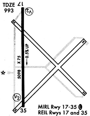
| A81-APT | ACTVT MIRL RY 17/35 AND REIL RWY 17 & RWY 35 - CTAF. |
| E111 | ESTAB PRIOR TO 1959. |
Runways
Runway Summary
| Runways: | 17/35 |
| Longest Runway: | 17/35 is 5103 ft (1555 m) long |
| Runways with an Instrument Approach: |
F22 Airport Runway Details
| Runway 17/35 | 5103 ft x 75 ft (1555 m x 23 m) | |
| Runway Length Source: | NGS as of 02/21/2014 | |
| Surface: | Asphalt - Fair condition - No special surface treatment | |
| Runway Edge Lights: | Medium Intensity | |
Runway Weight Bearing Capacity (in thousands of pounds) |
||
| Single Wheel Landing Gear: | 75.0 | |
| Dual Wheel Landing Gear: | 130.0 | |
Runway 17 |
Runway 35 |
|
Elevation: |
974.0 | 1002.4 |
Latitude: |
36-23-33.4257N | 36-22-42.9692N |
Longitude: |
097-16-38.1457W | 097-16-37.8517W |
|
Runway True Alignment: |
180 | 360 |
Glide Path Angle: |
3.0 degrees | 3.0 degrees |
Traffic Pattern: |
Left | Left |
Runway Markings Type: |
Nonprecision Instrument | Nonprecision Instrument |
Runway Markings Condition: |
Good | Good |
Object at End: |
ROAD | |
Object Height: |
20 | |
Distance from End: |
670 | |
Object Centerline Offset: |
0 ft. left and right of centerline | |
Visual Glide Slope Indicators: |
2-Light PAPI On Left Side Of Runway | 2-Light PAPI On Left Side Of Runway |
REIL: |
Yes | Yes |
Threshold Crossing Height: |
46 | 46 |
Services
Bottled Oxygen: |
None |
Bulk Oxygen: |
None |
Fuel Available: |
100LL |
Landing Fees: |
No |
Parking: |
Tiedowns available |
Maps & Diagrams
F22 Sectional
Flight Planning
at skyvector.com
at skyvector.com