Location
Latitude: |
28-49-22.4330N (28.822898) |
Longitude: |
081-48-30.3030W (-81.808418) |
Elevation: |
76.0 feet MSL (23 m MSL) |
Magnetic Variation: |
6.6 W (as of May 2024 from WMM2020 model) |
Time Zone: |
UTC -5.0 (Standard Time) UTC -4.0 (Daylight Savings Time) |
From City: |
03 N.M. NE of Leesburg, Florida |
Found On: |
Jacksonville Chart |
FAA Region: |
ASO |
Contacts
Manager: |
Publicly owned: |
| TRACEY DEAN PO BOX 490630 LEESBURG, FL 34749 (352) 728-9801 |
CITY OF LEESBURG PO BOX 490630 LEESBURG, FL 34749-0630 352-516-7236 |
Operations
Airport Status: |
Operational |
Facility Use: |
Public |
Type: |
Airport |
Activation Date: |
01/1943 |
Control tower: |
Yes |
Attendance (Months/Days/Hours): |
Months/Days/Hours ALL/ALL/0700-1900 |
Boundary ARTCC: |
ZJX (Jacksonville) |
Responsible ARTCC: |
ZJX (Jacksonville) |
Lighting Schedule: |
SEE RMK |
Segmented Circle Indicator: |
Yes, Lighted |
Traffic Pattern Altitude (MSL): |
1076 feet (328 m) |
NOTAMs Facility: |
LEE |
NOTAM-D Service: |
Yes |
International Airport of Entry: |
No |
Customs Landing Rights: |
No |
Military Landing Rights: |
Yes |
Civil/Military Joint Use: |
No |
Based Aircraft
| Single Engine: | 82 |
| Multi Engine: | 11 |
| Jet Engine: | 6 |
| GA Helicopters: | 25 |
Annual Operations (as of 09/30/2023)
| Total Operations: | 104235 | |
| GA Local: | 63732 | 61.1% |
| GA Itinerant: | 40408 | 38.8% |
| Military Aircraft: | 95 | 0.1% |
Communications
| CTAF: | 119.350 |
| Unicom: | 122.725 |
| Tower: | LEESBURG 119.35 Hrs: 0700-1900 |
| Ground: | 121.725 |
| Approach: | ORLANDO |
| Departure: | ORLANDO |
| ATIS: | 134.325 Hrs: 24 |
| ASOS: | (352-787-1565) |
Fixed Based Operators (FBOs) & Fuel
(Click on a business for detail)
Please help us keep this information up to date. This is a FREE SERVICE just like everything else on Airport Guide! If you see that a business needs to be added, modified, or deleted please fill out our Update Form.
To add, modify, or delete a business click here.
Please help us keep this information up to date. This is a FREE SERVICE just like everything else on Airport Guide! If you see that a business needs to be added, modified, or deleted please fill out our Update Form.
Area Code: 352 |
| Business Name | Frequency | Phone | Fuel Grade |
|---|---|---|---|
| AEROAGE
Update FBO info |
728-8582 | ||
| C-Wings, Inc.
Update FBO info |
Unicom 122.7 | 787-5128 | 100LL, Jet A |
| Florida Aircraft Instruments, Inc.
Update FBO info |
787-8566 | ||
| Phil's Aircraft Repair
Update FBO info |
315-0046 | ||
| Sunair Aviation, Inc.
Update FBO info |
Unicom 122.7 | 787-2211, 787-1208 | 100LL, Jet A |
| Triangle Aviation Service
Update FBO info |
Unicom 122.7 | 787-3447 |
Flight Service Stations
| Primary | Alternate | |
| FSS on Field: | N | |
| FSS Name (ID): | Saint Petersburg(PIE) | |
| Frequency: | ||
| Toll Free Phone: | 1-800-WX-BRIEF |
Instrument Procedures / Charts
FAA Terminal Procedures valid from 0901Z 03/21/24 to 0901Z 04/18/24.
There are various types of charts available for an airport. They are listed in the Page Type column. Here is a legend for those types:
APD - Airport Diagram
DP - Departure Procedure Charts
HOT - Hot Spots
IAP - Instrument Approach Procedure Charts
MIN - Minimums
STAR - Standard Terminal Arrival Charts
| Page Type | Page Name | Volume | Action Since Last Cycle |
|---|---|---|---|
| APD | AIRPORT DIAGRAM | SE-3 | |
| IAP | RNAV (GPS) RWY 04 | SE-3 | |
| IAP | RNAV (GPS) RWY 13 | SE-3 | Changed |
| IAP | RNAV (GPS) RWY 31 | SE-3 | Changed |
| MIN | ALTERNATE MINIMUMS | SE-3 | |
| MIN | TAKEOFF MINIMUMS | SE-3 | |
| STAR | ALYNA FOUR (RNAV) | SE-3 | |
| STAR | GOOFY SEVEN | SE-3 | Changed |
| STAR | JOKRS THREE (RNAV) | SE-3 | |
| STAR | JOKRS THREE (RNAV)[DELIMITER] CONT.1 | SE-3 | |
| STAR | MINEE FIVE | SE-3 | Changed |
| STAR | MINEE FIVE[DELIMITER] CONT.1 | SE-3 | |
| STAR | PRICY THREE (RNAV) | SE-3 | |
| STAR | PRICY THREE (RNAV)[DELIMITER] CONT.1 | SE-3 | |
| STAR | PRICY THREE (RNAV)[DELIMITER] CONT.2 | SE-3 | |
| STAR | RIDES TWO (RNAV) | SE-3 | |
| STAR | RIDES TWO (RNAV)[DELIMITER] CONT.1 | SE-3 | |
| STAR | RIDES TWO (RNAV)[DELIMITER] CONT.2 | SE-3 | |
| STAR | TTHOR THREE (RNAV) | SE-3 | |
| STAR | TTHOR THREE (RNAV)[DELIMITER] CONT.1 | SE-3 |
Terminal Procedures are only available for airports in several countries with more being added all the time. If you are looking for a specific country's charts, please send an email to support(at)airportguide.com stating the country name. This will be used to prioritize the implementation.
Navigation Aids (Navaids) near LEE
| Dist (NM) | ID | Morse Code | Name | Type | Freq | True Hdg | Mag Hdg |
|---|---|---|---|---|---|---|---|
| 0.3 | LEE | . _ . . . . | Leesburg | NDB | 335 | 168 | 175 |
| 27.4 | OR | _ _ _ . _ . | Herny | NDB | 221 | 133 | 140 |
| 29.8 | SFB | . . . . . _ . _ . . . | Sanford | NDB | 408 | 94 | 101 |
| 30.1 | ORL | _ _ _ . _ . . _ . . | Orlando | VORTAC | 112.20 | 123 | 130 |
| 30.6 | OCF | _ _ _ _ . _ . . . _ . | Ocala | VORTAC | 113.70 | 314 | 321 |
| 31.7 | DED | _ . . . _ . . | Deland/Dcmsnd | NDB | 201 | 62 | 69 |
| 40.2 | RHZ | . _ . . . . . _ _ . . | Zephyrhills | NDB | 253 | 207 | 213 |
| 45.0 | DAB | _ . . . _ _ . . . | Daytona Beach | VOT | 111.00 | 61 | 68 |
| 46.5 | OMN | _ _ _ _ _ _ . | Ormond Beach | VORTAC | 112.60 | 51 | 58 |
| 47.6 | EVB | . . . . _ _ . . . | New Smyrna Beach | NDB | 417 | 72 | 79 |
| 49.8 | IAK | . . . _ _ . _ | Palatka | NDB | 243 | 359 | 366 |
| 51.4 | LAL | . _ . . . _ . _ . . | Lakeland | VORTAC | 116.00 | 192 | 199 |
| 54.3 | GN | _ _ . _ . | Wynds | NDB | 269 | 339 | 346 |
| 56.5 | TVV | _ . . . _ . . . _ | Space Center Executive | NDB | 237 | 108 | 115 |
| 57.5 | GNV | _ _ . _ . . . . _ | Gators | VORTAC | 116.20 | 335 | 342 |
| 58.2 | TP | _ . _ _ . | Cosme | NDB | 368 | 220 | 226 |
| 63.7 | TPA | _ . _ _ . . _ | Tampa Intl | VOT | 111.00 | 217 | 223 |
| 68.5 | PI | . _ _ . . . | Capok | NDB | 360 | 223 | 229 |
| 68.7 | MCF | _ _ _ . _ . . . _ . | Macdill | TACAN | 111.00 | 213 | 219 |
| 69.1 | RYD | . _ . _ . _ _ _ . . | Reynolds | NDB | 338 | 6 | 13 |
Nearby Airports with Fuel
Notices to Airmen (NOTAMS)
Remarks
| A110-102 | BIRD ACT INVOF ARPT. |
| A110-103 | FOR CD OR TO CNL IFR IF UNA VIA GCO CTC ORLANDO APCH AT 407-852-7500. |
| A16 | EXT 1130 OR 352-728-9786. |
| A30-13/31 | 25 FT PAVED SHOULDERS EACH SIDE. TREES ALG SW SIDE OF RWY IN TRSN SFC. |
| A30A-04 | TREES 235 FT W OF CNTRLN FOR FIRST 1000 FT INSIDE PRI SFC. |
| A42-04 | MARKINGS FADED. |
| A42-22 | MARKINGS FADED. |
| A57-13 | APCH SLOPE 34:1 TO DSPLCD THR. |
| A57-22 | APCH SLOPE 21:1 TO DSPLCD THR. |
| A57-31 | APCH SLOPE 22:1 TO DSPLCD THR. |
| A58-04 | 25 FT TREES 235 FT LEFT OF CNTRLN 100 FT FM RWY END. |
| A58-22 | 11 FT BERM FULL WID OF RWY 81 FT FM RWY END. |
| A70-FUEL-10 | 0LL 24 HR SELF SERVE. |
| A81-APT | WHEN ATCT CLSD ACTVT REILS RWY 13 & 31; PAPI RWY 4, 13, 22, & 31; MIRL RWY 04/22 & 13/31; TWY LGTS - CTAF. |
| E111 | EXISTED PRIOR TO 1959. |
| E80 | US CUSTOMS USER FEE ARPT. |
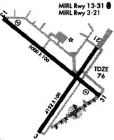
Runways
Runway Summary
| Runways: | 03W/21W 04/22 13/31 |
| Longest Runway: | 03W/21W is 15000 ft (4572 m) long |
| Runways with an Instrument Approach: |
LEE Airport Runway Details
| Waterway 03W/21W | 15000 ft x 2000 ft (4572 m x 610 m) | |
| Runway Length Source: | FAA as of 01/10/2019 | |
| Surface: | Water - No special surface treatment | |
Waterway 03W |
Runway 21W |
|
Elevation: |
63.0 | 63.0 |
Glide Path Angle: |
0.0 degrees | 0.0 degrees |
| Waterway 04/22 | 4957 ft x 100 ft (1511 m x 30 m) | |
| Runway Length Source: | 3RD PARTY SURVEY as of 02/05/2021 | |
| Surface: | Water - No special surface treatment | |
| Runway Pavement Class: | 14 /F/B/Y/T | |
| Runway Edge Lights: | Medium Intensity | |
Runway Weight Bearing Capacity (in thousands of pounds) |
||
| Single Wheel Landing Gear: | 21.0 | |
Waterway 04 |
Runway 22 |
|
Elevation: |
66.7 | 75.2 |
Latitude: |
28-48-58.1729N | 28-49-38.3761N |
Longitude: |
081-48-42.4458W | 081-48-10.4923W |
|
Runway True Alignment: |
035 | 215 |
Glide Path Angle: |
3.0 degrees | 3.0 degrees |
Traffic Pattern: |
Left | Left |
Runway Markings Type: |
Nonprecision Instrument | Basic |
Runway Markings Condition: |
Poor | Poor |
Object at End: |
TREES | BERM |
Object Height: |
38 | 11 |
Distance from End: |
100 | 81 |
Visual Glide Slope Indicators: |
4-Light PAPI On Left Side Of Runway | 4-Light PAPI On Right Side Of Runway |
Threshold Crossing Height: |
45 | 45 |
Threshold Elevation: |
73.8 | |
Displaced Threshold: |
310 | |
Threshold Latitude: |
28-49-35.8564N | |
Threshold Longitude: |
081-48-12.4904W | |
Declared Distances |
||
Take Off Run Avbl. (TORA): |
4957 | 4957 |
Take Off Distance Avbl. (TODA): |
4957 | 4957 |
Actual Stop Dist. Avbl. (ASDA): |
4688 | 4647 |
Landing Dist. Avbl. (LDA): |
4688 | 4957 |
| Waterway 13/31 | 6300 ft x 100 ft (1920 m x 30 m) | |
| Runway Length Source: | 3RD PARTY SURVEY as of 02/05/2021 | |
| Surface: | Water - Saw-cut or plastic grooved | |
| Runway Pavement Class: | 17 /F/B/Y/T | |
| Runway Edge Lights: | Medium Intensity | |
Runway Weight Bearing Capacity (in thousands of pounds) |
||
| Dual Wheel Landing Gear: | 60.0 | |
Waterway 13 |
Runway 31 |
|
Elevation: |
72.1 | 66.3 |
Latitude: |
28-49-45.6672N | 28-49-05.7422N |
Longitude: |
081-49-00.5230W | 081-48-06.1172W |
|
Runway True Alignment: |
130 | 310 |
Glide Path Angle: |
3.0 degrees | 3.0 degrees |
Traffic Pattern: |
Left | Left |
Runway Markings Type: |
Nonprecision Instrument | Nonprecision Instrument |
Runway Markings Condition: |
Good | Good |
Object at End: |
TREES | BRUSH |
Object Height: |
68 | 15 |
Distance from End: |
1982 | 215 |
Visual Glide Slope Indicators: |
4-Light PAPI On Left Side Of Runway | 4-Light PAPI On Left Side Of Runway |
REIL: |
Yes | Yes |
Threshold Crossing Height: |
40 | 40 |
Threshold Elevation: |
73.8 | 66.9 |
Displaced Threshold: |
290 | 400 |
Threshold Latitude: |
28-49-43.8315N | 28-49-08.2788N |
Threshold Longitude: |
081-48-58.0230W | 081-48-09.5713W |
Declared Distances |
||
Take Off Run Avbl. (TORA): |
6300 | 6300 |
Take Off Distance Avbl. (TODA): |
6300 | 6300 |
Actual Stop Dist. Avbl. (ASDA): |
5500 | 6000 |
Landing Dist. Avbl. (LDA): |
5211 | 5600 |
Services
Airframe Repair: |
Minor |
Powerplant Repair: |
Minor |
Bottled Oxygen: |
None |
Bulk Oxygen: |
None |
Fuel Available: |
100LL |
Landing Fees: |
No |
Parking: |
Hangars and tiedowns available |
Maps & Diagrams
LEE Sectional
Flight Planning
at skyvector.com
at skyvector.com