Location
Latitude: |
40-56-51.4610N (40.947628) |
Longitude: |
074-18-52.2400W (-74.314511) |
Elevation: |
181.0 feet MSL (55 m MSL) |
Magnetic Variation: |
12.5 W (as of April 2024 from WMM2020 model) |
Time Zone: |
UTC -5.0 (Standard Time) UTC -4.0 (Daylight Savings Time) |
From City: |
02 N.M. N of Lincoln Park, New Jersey |
Found On: |
New York Chart |
FAA Region: |
AEA |
Contacts
Manager: |
Privately owned: |
| TOM VAN WINGERDEN 425 BEAVER BROOK ROAD LINCOLN PARK, NJ 07035 973-628-7166 |
PETER DEROSA 425 BEAVER BROOK ROAD LINCOLN PARK, NJ 07035 973-628-7166 |
Operations
Airport Status: |
Operational |
Facility Use: |
Public |
Type: |
Airport |
Activation Date: |
01/1939 |
Control tower: |
No |
Attendance (Months/Days/Hours): |
Months/Days/Hours ALL/MON-FRI/0900-DUSK |
Boundary ARTCC: |
ZNY (New York) |
Responsible ARTCC: |
ZNY (New York) |
Lighting Schedule: |
SEE RMK |
Segmented Circle Indicator: |
No |
Traffic Pattern Altitude (MSL): |
1181 feet (360 m) |
NOTAMs Facility: |
MIV |
NOTAM-D Service: |
Yes |
International Airport of Entry: |
No |
Customs Landing Rights: |
No |
Military Landing Rights: |
No |
Civil/Military Joint Use: |
No |
Based Aircraft
| Single Engine: | 106 |
| Multi Engine: | 4 |
| Jet Engine: | 1 |
| GA Helicopters: | 7 |
Annual Operations (as of 06/30/2023)
| Total Operations: | 46175 | |
| GA Local: | 32350 | 70.1% |
| GA Itinerant: | 13825 | 29.9% |
Communications
| CTAF: | 122.800 |
| Unicom: | 122.800 |
| Approach: | NEW YORK 127.6 127.6 |
| Departure: | NEW YORK 127.6 127.6 |
Fixed Based Operators (FBOs) & Fuel
(Click on a business for detail)
Please help us keep this information up to date. This is a FREE SERVICE just like everything else on Airport Guide! If you see that a business needs to be added, modified, or deleted please fill out our Update Form.
To add, modify, or delete a business click here.
Please help us keep this information up to date. This is a FREE SERVICE just like everything else on Airport Guide! If you see that a business needs to be added, modified, or deleted please fill out our Update Form.
Area Code: 201 |
| Business Name | Frequency | Phone | Fuel Grade |
|---|---|---|---|
| Lincoln Park Aviation
Update FBO info |
Unicom 123.0 | 973-872-2278 | 100LL, Jet A |
Flight Service Stations
| Primary | Alternate | |
| FSS on Field: | N | |
| FSS Name (ID): | Millville(MIV) | |
| Frequency: | ||
| Toll Free Phone: | 1-800-WX-BRIEF |
Instrument Procedures / Charts
FAA Terminal Procedures valid from 0901Z 03/21/24 to 0901Z 04/18/24.
There are various types of charts available for an airport. They are listed in the Page Type column. Here is a legend for those types:
APD - Airport Diagram
DP - Departure Procedure Charts
HOT - Hot Spots
IAP - Instrument Approach Procedure Charts
MIN - Minimums
STAR - Standard Terminal Arrival Charts
| Page Type | Page Name | Volume | Action Since Last Cycle |
|---|---|---|---|
| IAP | RNAV (GPS) RWY 01 | NE-2 | |
| IAP | RNAV (GPS) RWY 19 | NE-2 | |
| MIN | TAKEOFF MINIMUMS | NE-2 | |
| STAR | MAZIE THREE (RNAV) | NE-2 |
Terminal Procedures are only available for airports in several countries with more being added all the time. If you are looking for a specific country's charts, please send an email to support(at)airportguide.com stating the country name. This will be used to prioritize the implementation.
Navigation Aids (Navaids) near N07
| Dist (NM) | ID | Morse Code | Name | Type | Freq | True Hdg | Mag Hdg |
|---|---|---|---|---|---|---|---|
| 11.9 | TE | _ . | Torby | NDB | 214 | 136 | 149 |
| 12.4 | SAX | . . . . _ _ . . _ | Sparta | VORTAC | 115.70 | 305 | 317 |
| 12.9 | TEB | _ . _ . . . | Teterboro | VOR-DME | 108.40 | 117 | 130 |
| 13.5 | CAT | _ . _ . . _ _ | Chatham | NDB | 254 | 202 | 214 |
| 15.7 | EWR | . . _ _ . _ . | Maryann | FAN MARKER | 158 | 171 | |
| 17.5 | EWR | . . _ _ . _ . | Newark | DME | 113.75 | 159 | 172 |
| 22.5 | LGA | . _ . . _ _ . . _ | La Guardia | VOR-DME | 113.10 | 115 | 128 |
| 24.7 | BWZ | _ . . . . _ _ _ _ . . | Broadway | VOR-DME | 114.20 | 248 | 260 |
| 25.3 | STW | . . . _ . _ _ | Stillwater | VOR-DME | 109.60 | 276 | 288 |
| 27.7 | CRI | _ . _ . . _ . . . | Canarsie | VOR-DME | 112.30 | 136 | 149 |
| 29.3 | SBJ | . . . _ . . . . _ _ _ | Solberg | VOR-DME | 112.90 | 221 | 233 |
| 30.1 | OGY | _ _ _ _ _ . _ . _ _ | Bridge | NDB | 414 | 139 | 152 |
| 30.4 | HUO | . . . . . . _ _ _ _ | Huguenot | VOR-DME | 116.10 | 335 | 347 |
| 31.1 | JFK | . _ _ _ . . _ . _ . _ | Kennedy | VOR-DME | 115.90 | 127 | 140 |
| 32.5 | SW | . . . . _ _ | Neely | NDB | 335 | 6 | 19 |
| 36.9 | SKU | . . . _ . _ . . _ | Stanwyck | NDB | 261 | 19 | 32 |
| 36.9 | SKU | . . . _ . _ . . _ | Stanwyck | FAN MARKER | 19 | 32 | |
| 38.7 | CMK | _ . _ . _ _ _ . _ | Carmel | VOR-DME | 116.60 | 58 | 71 |
| 38.8 | COL | _ . _ . _ _ _ . _ . . | Colts Neck | VOR-DME | 115.40 | 169 | 181 |
| 39.1 | FR | . . _ . . _ . | Frikk | NDB | 407 | 104 | 117 |
Nearby Airports with Fuel
Notices to Airmen (NOTAMS)
Remarks
| A110-1 | NARROW TAXILANES & TWYS CAUSED BY NSTD CLNCS. |
| A110-3 | DEER AND BIRDS INVOF RUNWAY. |
| A110-4 | GCO AVBL ON FREQ 121.725. |
| A110-5 | TOUCH AND GO LANDINGS PROHIBITED. |
| A110-6 | FOR CD CTC NEW YORK APCH AT 800-645-3206. |
| A110-7 | TSNT HEL OPS ALLOWED WITH PRE-APVL ONLY, CALL 973-628-7166. |
| A110-8 | (CONTACT TITLE) FBO CTC (973) 633-0450. |
| A57-01 | +50 FT TREE LINE 0-680 FT AND 90-160 FT R; APCH RATIO 0:1 BASED ON DSPLCD THLD. |
| A57-19 | APCH RATIO 7:1 TO DSPLCD THLD. |
| A58-01 | +75 FT TREES 0-200 FT FROM RWY END 250 L - 250 R. |
| A58-19 | +30 FT HGR 80 FT FROM RWY END 200 FT L. |
| A81-APT | ACTVT HIRL RY 01/19 - CTAF. ACTVT HIGH INTST FST WITH 7 CLICKS BFR ACTVTNG LOWER INTSTS. |
| E111 | ESTAB PRIOR TO 1936. |
Runways
Runway Summary
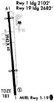
| Runways: | 01/19 |
| Longest Runway: | 01/19 is 2767 ft (843 m) long |
| Runways with an Instrument Approach: |
N07 Airport Runway Details
| Runway 01/19 | 2767 ft x 40 ft (843 m x 12 m) | |
| Runway Length Source: | 3RD PARTY SURVEY as of 10/12/2017 | |
| Surface: | Asphalt - Good condition - No special surface treatment | |
| Runway Edge Lights: | High Intensity | |
Runway 01 |
Runway 19 |
|
Elevation: |
177.0 | 180.6 |
Latitude: |
40-56-37.8344N | 40-57-05.0869N |
Longitude: |
074-18-50.7918W | 074-18-53.6883W |
|
Runway True Alignment: |
355 | 175 |
Glide Path Angle: |
0.0 degrees | 4.0 degrees |
Traffic Pattern: |
Left | Left |
Runway Markings Type: |
Nonprecision Instrument | Nonprecision Instrument |
Runway Markings Condition: |
Good | Good |
Object at End: |
TREES | STACK |
Object Height: |
50 | 20 |
Distance from End: |
200 | 260 |
Object Centerline Offset: |
60 ft. right of centerline | 155 ft. left of centerline |
Visual Glide Slope Indicators: |
2-Light PAPI On Left Side Of Runway | |
Threshold Crossing Height: |
30 | |
Threshold Elevation: |
179.4 | 180.8 |
Displaced Threshold: |
690 | 95 |
Threshold Latitude: |
40-56-44.6288N | 40-57-04.1463N |
Threshold Longitude: |
074-18-51.5136W | 074-18-53.5895W |
Services
Airframe Repair: |
Major |
Powerplant Repair: |
Major |
Bottled Oxygen: |
None |
Bulk Oxygen: |
Low Pressure |
Fuel Available: |
100LL |
Landing Fees: |
No |
Parking: |
Tiedowns available |
Maps & Diagrams
N07 Sectional
Flight Planning
at skyvector.com
at skyvector.com