Location
Latitude: |
40-47-57.6180N (40.799338) |
Longitude: |
074-24-53.5990W (-74.414889) |
Elevation: |
186.6 feet MSL (57 m MSL) |
Magnetic Variation: |
12.4 W (as of April 2024 from WMM2020 model) |
Time Zone: |
UTC -5.0 (Standard Time) UTC -4.0 (Daylight Savings Time) |
From City: |
03 N.M. E of Morristown, New Jersey |
Found On: |
New York Chart |
FAA Region: |
AEA |
Contacts
Manager: |
Publicly owned: |
| SCOTT MCMAHON DM AIRPORTS, LTD., 8 AIRPORT ROAD MORRISTOWN, NJ 07960 973-538-6400 |
TOWN OF MORRISTOWN 110 SOUTH STREET MORRISTOWN, NJ 07960 973-292-6626 |
Operations
Airport Status: |
Operational |
Facility Use: |
Public |
Type: |
Airport |
Activation Date: |
05/1943 |
Control tower: |
Yes |
Attendance (Months/Days/Hours): |
Months/Days/Hours ALL/ALL/0645-2230 |
Boundary ARTCC: |
ZNY (New York) |
Responsible ARTCC: |
ZNY (New York) |
Lighting Schedule: |
SEE RMK |
Segmented Circle Indicator: |
Yes |
Traffic Pattern Altitude (MSL): |
1187 feet (362 m) |
NOTAMs Facility: |
MMU |
NOTAM-D Service: |
Yes |
International Airport of Entry: |
No |
Customs Landing Rights: |
No |
Military Landing Rights: |
Yes |
Civil/Military Joint Use: |
No |
Based Aircraft
| Single Engine: | 78 |
| Multi Engine: | 16 |
| Jet Engine: | 67 |
| GA Helicopters: | 7 |
Annual Operations (as of 07/31/2022)
| Total Operations: | 110939 | |
| Commercial: | 6 | 0.0% |
| Air Taxi: | 12852 | 11.6% |
| GA Local: | 45767 | 41.3% |
| GA Itinerant: | 52233 | 47.1% |
| Military Aircraft: | 81 | 0.1% |
Communications
| CTAF: | 118.100 |
| Tower: | MORRISTOWN 118.1 353.9 Hrs: 0645-2230 |
| Clearance Del.: | 128.6 |
| Ground: | 134.2 |
| Approach: | NEW YORK |
| Departure: | NEW YORK |
| ATIS: | 124.25 Hrs: 24 |
| AWOS-3: | (973-290-0135) |
| EMERG: | 121.5 |
| EMERG: | 243.0 |
- CALL 516-542-3690 WHEN TWR CLSD.
Fixed Based Operators (FBOs) & Fuel
(Click on a business for detail)
Please help us keep this information up to date. This is a FREE SERVICE just like everything else on Airport Guide! If you see that a business needs to be added, modified, or deleted please fill out our Update Form.
To add, modify, or delete a business click here.
Please help us keep this information up to date. This is a FREE SERVICE just like everything else on Airport Guide! If you see that a business needs to be added, modified, or deleted please fill out our Update Form.
Area Code: 973 |
| Business Name | Frequency | Phone | Fuel Grade |
|---|---|---|---|
| Century Flight Academy (Century Air Inc.)
Website Update FBO info |
(973) 455-1770 | ||
| D. M. Airport Developers, Inc.
Update FBO info |
Unicom 122.95 | 538-6400 | |
| Jet Support Systems, Inc.
Update FBO info |
539-8500 | 100LL, Jet A | |
| Signature Flight Support
Update FBO info |
Unicom: 118.1, Arinc: 129.6 | +1 973 292 1300 | |
| Signature Flight Support
Website Update FBO info |
Arinc 129.6 | +1 973 292 1300 | 100LL, Jet A |
Flight Service Stations
| Primary | Alternate | |
| FSS on Field: | N | |
| FSS Name (ID): | Millville(MIV) | |
| Frequency: | ||
| Toll Free Phone: | 1-800-WX-BRIEF |
Instrument Procedures / Charts
FAA Terminal Procedures valid from 0901Z 03/21/24 to 0901Z 04/18/24.
There are various types of charts available for an airport. They are listed in the Page Type column. Here is a legend for those types:
APD - Airport Diagram
DP - Departure Procedure Charts
HOT - Hot Spots
IAP - Instrument Approach Procedure Charts
MIN - Minimums
STAR - Standard Terminal Arrival Charts
| Page Type | Page Name | Volume | Action Since Last Cycle |
|---|---|---|---|
| APD | AIRPORT DIAGRAM | NE-2 | |
| DP | MORRISTOWN SEVEN | NE-2 | |
| DP | MORRISTOWN SEVEN[DELIMITER] CONT.1 | NE-2 | |
| IAP | ILS OR LOC RWY 23 | NE-2 | |
| IAP | RNAV (GPS) RWY 05 | NE-2 | |
| IAP | RNAV (GPS) Z RWY 23 | NE-2 | |
| IAP | RNAV (RNP) Y RWY 23 | NE-2 | |
| IAP | ROUTE 80 VISUAL RWY 23 | NE-2 | |
| MIN | ALTERNATE MINIMUMS | NE-2 | |
| MIN | TAKEOFF MINIMUMS | NE-2 | |
| STAR | JAIKE FOUR (RNAV) | NE-2 | |
| STAR | JAIKE FOUR (RNAV)[DELIMITER] CONT.1 | NE-2 | |
| STAR | MAZIE THREE (RNAV) | NE-2 | |
| STAR | WILKES-BARRE FOUR | NE-2 |
Terminal Procedures are only available for airports in several countries with more being added all the time. If you are looking for a specific country's charts, please send an email to support(at)airportguide.com stating the country name. This will be used to prioritize the implementation.
Navigation Aids (Navaids) near MMU
| Dist (NM) | ID | Morse Code | Name | Type | Freq | True Hdg | Mag Hdg |
|---|---|---|---|---|---|---|---|
| 3.6 | CAT | _ . _ . . _ _ | Chatham | NDB | 254 | 190 | 202 |
| 11.8 | EWR | . . _ _ . _ . | Maryann | FAN MARKER | 119 | 131 | |
| 12.8 | TE | _ . | Torby | NDB | 214 | 88 | 101 |
| 13.1 | EWR | . . _ _ . _ . | Newark | DME | 113.75 | 124 | 136 |
| 16.3 | TEB | _ . _ . . . | Teterboro | VOR-DME | 108.40 | 79 | 92 |
| 17.0 | SAX | . . . . _ _ . . _ | Sparta | VORTAC | 115.70 | 340 | 352 |
| 18.5 | BWZ | _ . . . . _ _ _ _ . . | Broadway | VOR-DME | 114.20 | 269 | 281 |
| 19.7 | SBJ | . . . _ . . . . _ _ _ | Solberg | VOR-DME | 112.90 | 228 | 240 |
| 23.7 | STW | . . . _ . _ _ | Stillwater | VOR-DME | 109.60 | 299 | 311 |
| 24.8 | LGA | . _ . . _ _ . . _ | La Guardia | VOR-DME | 113.10 | 91 | 104 |
| 26.2 | CRI | _ . _ . . _ . . . | Canarsie | VOR-DME | 112.30 | 115 | 128 |
| 27.9 | OGY | _ _ _ _ _ . _ . _ _ | Bridge | NDB | 414 | 119 | 132 |
| 30.9 | JFK | . _ _ _ . . _ . _ . _ | Kennedy | VOR-DME | 115.90 | 108 | 121 |
| 31.5 | COL | _ . _ . _ _ _ . _ . . | Colts Neck | VOR-DME | 115.40 | 158 | 170 |
| 36.0 | RBV | . _ . _ . . . . . . _ | Robbinsville | VORTAC | 113.80 | 185 | 197 |
| 37.5 | HUO | . . . . . . _ _ _ _ | Huguenot | VOR-DME | 116.10 | 347 | 359 |
| 39.7 | ARD | . _ . _ . _ . . | Yardley | VOR-DME | 108.20 | 214 | 226 |
| 42.0 | SW | . . . . _ _ | Neely | NDB | 335 | 11 | 24 |
| 42.4 | FR | . . _ . . _ . | Frikk | NDB | 407 | 91 | 104 |
| 45.4 | NEL | _ . . . _ . . | Lakehurst | NDB | 396 | 175 | 187 |
Nearby Airports with Fuel
Notices to Airmen (NOTAMS)
Remarks
| A110-1 | BIRDS & DEER ON & INVOF ARPT. |
| A110-10 | ARFF SVCS AVBL 24 HRS DAILY. FOR ARFF SVCS WHEN ATCT CLSD CTC ARFF STATION; CTAF OR 973-455-1953. |
| A110-11 | ALL ARRIVAL/DEPARTURE ACFT FOLLOW MANUFACTURERS RECOMMENDED PROCEDURES FOR QUIET OPNS & MINIMUM NOISE. |
| A110-12 | ROUTE 80 VISUAL APCH PREFERRED FOR RY 23. |
| A110-13 | HELICOPTER OPNS OVER RESIDENTIAL AREAS BLO 1000 FT MSL SHOULD BE AVOIDED. |
| A110-15 | STAGE I DEPARTURE FEE 2300-0645. |
| A110-16 | DURG SNOW REMOVAL OPNS 15 MINUTE PRIOR NOTICE REQUIRED ON 118.1 & NO PRACTICE LOW APCHS OR TOUCH & GO LDGS. |
| A110-17 | INBOUND TFC REQUEST FBO SVCS, INSTRUCTIONS & RAMP ADVISORIES 30 MINUTES PRIOR TO ARRIVAL. AFTER LDG CTC FBO AGAIN 129.6 FOR PREFERRED RAMP ENTRANCE TO DELTA OR JULIET TWYS. |
| A110-18 | TAXILANE K N OF LYNX FBO RAMP, NO HEL OR ACFT WITH A WINGSPAN GTR THAN 50 FT. |
| A110-19 | VOLUNTARY NOISE ABATEMENT PROC INCLUDE AVOIDING TGL OPS ON RWY 13-31. |
| A110-2 | NOISE ABATEMENT PROC IN EFCT; CTC NOISE ABATEMENT OFFICE 973-538-3366 EXTN 122. |
| A110-20 | FOR CD WHEN ATCT IS CLSD CTC NEW YORK APCH AT 800-645-3206. |
| A110-21 | NO TGL ON RWY 13/31 UNLESS THE CROSSWIND VLCTY FOR RWY 05/23 EXCEEDS 10 KTS. |
| A110-3 | US CUSTOMS AVBL MON-FRI 0800-1600; BTN 1601-0759 & WKENDS CALL 973-267-0302 FOR APPOINTMENT. MORRISTOWN CUSTOMS ASSOCIATION FEES APPLY; CTC AMGR 973-538-6400 FOR DETAILS. |
| A110-4 | NO TURBOJET LNDG ON RWY 13 & 31 UNLESS THE X-WIND VELOCITY FOR RWY 5/23 EXCEEDS 16 KNOTS. |
| A110-7 | ACFT CARRYING EXPLOSIVE CARGO PPR BEFORE LDG - CALL 973-538-6400. |
| A110-8 | FLIGHT NOTIFICATION SVC (ADCUS) AVBL. |
| A110-9 | U.S. CUSTOMS USER FEE ARPT. |
| A70-FUEL-A | O-128 AVOIL AVBL. |
| A81-APT | DUSK-DAWN; ACTVT HIRL RWY 05/23, MIRL RW 13/31, REIL RWY 05 & 31, MALSR RWY 23 & PAPI RWY 31 - CTAF. |
| E100 | WHEN TWR CLSD ALL ACFT AND VEHICLES MUST STATE INTNS ON CTAF BFR OPS ON ANY RWY. |
| E147 | TPA 1013 LIGHT ACFT, 1513 HEAVY ACFT. |
| E80 | US CUSTOMS USER FEE ARPT. |
Runways
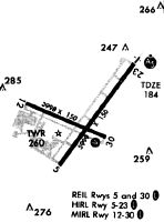
Runway Summary
| Runways: | 05/23 13/31 |
| Longest Runway: | 05/23 is 5998 ft (1828 m) long |
| Runways with an Instrument Approach: | 23 |
MMU Airport Runway Details
| Runway 05/23 | 5998 ft x 150 ft (1828 m x 46 m) | |
| Runway Length Source: | 3RD PARTY SURVEY as of 06/24/2016 | |
| Surface: | Asphalt - Good condition - Saw-cut or plastic grooved | |
| Runway Pavement Class: | 25 /F/C/X/T | |
| Runway Edge Lights: | High Intensity | |
Runway Weight Bearing Capacity (in thousands of pounds) |
||
| Single Wheel Landing Gear: | 30.0 | |
| Dual Wheel Landing Gear: | 80.0 | |
Runway 05 |
Runway 23 |
|
Elevation: |
181.8 | 182.8 |
Latitude: |
40-47-35.1745N | 40-48-23.0596N |
Longitude: |
074-25-09.2707W | 074-24-23.3079W |
|
Runway True Alignment: |
036 | 216 |
ILS Type: |
ILS | |
Glide Path Angle: |
0.0 degrees | 0.0 degrees |
Traffic Pattern: |
Left | Left |
Runway Markings Type: |
Precision Instrument | Precision Instrument |
Runway Markings Condition: |
Good | Good |
Object at End: |
TREES | |
Object Height: |
102 | |
Distance from End: |
2100 | |
Object Centerline Offset: |
0 ft. left and right of centerline | |
Approach Light System: |
1,400 Foot Medium Intensity Approach Lighting System With Runway Alignment Indicator Lights | |
REIL: |
Yes |
| Runway 13/31 | 3997 ft x 150 ft (1218 m x 46 m) | |
| Runway Length Source: | 3RD PARTY SURVEY as of 06/24/2016 | |
| Surface: | Asphalt - Good condition - Saw-cut or plastic grooved | |
| Runway Pavement Class: | 11 /F/C/X/T | |
| Runway Edge Lights: | Medium Intensity | |
Runway Weight Bearing Capacity (in thousands of pounds) |
||
| Single Wheel Landing Gear: | 30.0 | |
Runway 13 |
Runway 31 |
|
Elevation: |
186.5 | 181.3 |
Latitude: |
40-48-03.3782N | 40-47-47.3557N |
Longitude: |
074-25-28.3188W | 074-24-40.8111W |
|
Runway True Alignment: |
114 | 294 |
Glide Path Angle: |
0.0 degrees | 3.5 degrees |
Traffic Pattern: |
Left | Left |
Runway Markings Type: |
Basic | Basic |
Runway Markings Condition: |
Good | Good |
Object at End: |
TREES | TREES |
Object Height: |
49 | 91 |
Distance from End: |
320 | 1690 |
Object Centerline Offset: |
0 ft. left and right of centerline | |
Visual Glide Slope Indicators: |
2-Light PAPI On Left Side Of Runway | |
REIL: |
Yes | |
Threshold Crossing Height: |
39 |
Services
Airframe Repair: |
None |
Powerplant Repair: |
None |
Bottled Oxygen: |
None |
Bulk Oxygen: |
None |
Fuel Available: |
100LL |
Landing Fees: |
No |
Parking: |
Tiedowns available |
Maps & Diagrams
MMU Sectional
Flight Planning
at skyvector.com
at skyvector.com