Location
Latitude: |
42-03-00.3000N (42.050083) |
Longitude: |
090-44-19.7000W (-90.738806) |
Elevation: |
769.4 feet MSL (235 m MSL) |
Magnetic Variation: |
1.8 W (as of April 2024 from WMM2020 model) |
Time Zone: |
UTC -6.0 (Standard Time) UTC -5.0 (Daylight Savings Time) |
From City: |
03 N.M. W of Maquoketa, Iowa |
Found On: |
Chicago Chart |
FAA Region: |
ACE |
Contacts
Manager: |
Publicly owned: |
| FRANK ELLENZ 201 EAST PLEASANT STREET MAQUOKETA, IA 52060-9671 563-652-4628 |
CITY OF MAQUOKETA 201 EAST PLEASANT STREET MAQUOKETA, IA 52060 563-652-2484 |
Operations
Airport Status: |
Operational |
Facility Use: |
Public |
Type: |
Airport |
Activation Date: |
10/1958 |
Control tower: |
No |
Attendance (Months/Days/Hours): |
Months/Days/Hours Unattended |
Boundary ARTCC: |
ZAU (Chicago) |
Responsible ARTCC: |
ZAU (Chicago) |
Lighting Schedule: |
SEE RMK |
Segmented Circle Indicator: |
No |
Traffic Pattern Altitude (MSL): |
1769 feet (539 m) |
NOTAMs Facility: |
FOD |
NOTAM-D Service: |
Yes |
Military Landing Rights: |
No |
Civil/Military Joint Use: |
No |
Based Aircraft
| Single Engine: | 10 |
Annual Operations (as of 07/19/2023)
| Total Operations: | 1500 | |
| GA Itinerant: | 1500 | 100.0% |
Communications
| CTAF: | 122.725 |
| Unicom: | 122.725 |
- APCH/DEP SVC PRVDD BY CHICAGO ARTCC ON FREQS 133.95/281.4 (DUBUQUE RCAG).
Fixed Based Operators (FBOs) & Fuel
(Click on a business for detail)
Please help us keep this information up to date. This is a FREE SERVICE just like everything else on Airport Guide! If you see that a business needs to be added, modified, or deleted please fill out our Update Form.
To add, modify, or delete a business click here.
Please help us keep this information up to date. This is a FREE SERVICE just like everything else on Airport Guide! If you see that a business needs to be added, modified, or deleted please fill out our Update Form.
Area Code: 319 |
| Business Name | Frequency | Phone | Fuel Grade |
|---|---|---|---|
| Brandt Aviation, Inc.
Update FBO info |
Unicom 122.8 | 652-5618 | 100LL, Jet A |
Flight Service Stations
| Primary | Alternate | |
| FSS on Field: | N | |
| FSS Name (ID): | Fort Dodge(FOD) | |
| Frequency: | ||
| Toll Free Phone: | 1-800-WX-BRIEF |
Instrument Procedures / Charts
FAA Terminal Procedures valid from 0901Z 03/21/24 to 0901Z 04/18/24.
There are various types of charts available for an airport. They are listed in the Page Type column. Here is a legend for those types:
APD - Airport Diagram
DP - Departure Procedure Charts
HOT - Hot Spots
IAP - Instrument Approach Procedure Charts
MIN - Minimums
STAR - Standard Terminal Arrival Charts
| Page Type | Page Name | Volume | Action Since Last Cycle |
|---|---|---|---|
| IAP | RNAV (GPS) RWY 15 | NC-3 | |
| IAP | RNAV (GPS) RWY 33 | NC-3 | |
| MIN | TAKEOFF MINIMUMS | NC-3 |
Terminal Procedures are only available for airports in several countries with more being added all the time. If you are looking for a specific country's charts, please send an email to support(at)airportguide.com stating the country name. This will be used to prioritize the implementation.
Navigation Aids (Navaids) near KOQW
| Dist (NM) | ID | Morse Code | Name | Type | Freq | True Hdg | Mag Hdg |
|---|---|---|---|---|---|---|---|
| 17.5 | DB | _ . . _ . . . | Zilom | NDB | 341 | 20 | 22 |
| 21.1 | DBQ | _ . . _ . . . _ _ . _ | Dubuque | VORTAC | 115.80 | 3 | 5 |
| 23.5 | CVA | _ . _ . . . . _ . _ | Davenport | VORTAC | 113.80 | 150 | 152 |
| 23.7 | FN | . . _ . _ . | Hillz | NDB | 517 | 138 | 140 |
| 27.2 | DVN | _ . . . . . _ _ . | Davenport Municipal | VOT | 111.80 | 165 | 167 |
| 44.0 | MZV | _ _ _ _ . . . . . _ | Moline | VOR-DME | 114.40 | 174 | 176 |
| 45.0 | DDD | _ . . _ . . _ . . | Port City | DME | 116.5 | 204 | 206 |
| 47.2 | BOZ | _ . . . _ _ _ _ _ . . | Whiteside | NDB | 254 | 115 | 117 |
| 47.7 | CID | _ . _ . . . _ . . | Cedar Rapids | VOR-DME | 114.10 | 258 | 259 |
| 50.5 | IOW | . . _ _ _ . _ _ | Iowa City | VOR-DME | 116.20 | 231 | 232 |
| 54.4 | PLL | . _ _ . . _ . . . _ . . | Polo | VOR-DME | 111.20 | 94 | 96 |
| 55.2 | MRJ | _ _ . _ . . _ _ _ | Mineral Point | NDB | 365 | 24 | 26 |
| 59.0 | IIB | . . . . _ . . . | Wapsie | NDB | 206 | 294 | 295 |
| 62.4 | AWG | . _ . _ _ _ _ . | Washington | NDB | 219 | 222 | 223 |
| 68.2 | GBG | _ _ . _ . . . _ _ . | Galesburg | DME | 109.8 | 168 | 170 |
| 69.3 | RFD | . _ . . . _ . _ . . | Rockford | DME | 110.8 | 80 | 82 |
| 73.1 | RF | . _ . . . _ . | Gilmy | NDB | 275 | 86 | 88 |
| 74.3 | BDF | _ . . . _ . . . . _ . | Bradford | VORTAC | 114.70 | 135 | 137 |
| 74.7 | MPZ | _ _ . _ _ . _ _ . . | Mount Pleasant | NDB | 212 | 208 | 209 |
| 78.6 | JVL | . _ _ _ . . . _ . _ . . | Janesville | VOR-DME | 114.30 | 66 | 68 |
Nearby Airports with Fuel
Notices to Airmen (NOTAMS)
Remarks
| A110-1 | ULTRALIGHT ACTVTY ON & INVOF ARPT. |
| A110-2 | RY 33 IS CALM WIND RY. |
| A110-3 | FOR CD CTC CHICAGO ARTCC AT 630-906-8921. |
| A17 | SVC AVBL AT 1-800-553-5283. |
| A43-15 | RWY 15 PAPI UNUSBL BYD 8 DEG RIGHT OF CNTRLN. |
| A43-33 | RWY 33 PAPI UNUSBL BYD 8 DEG RIGHT OF CNTRLN. |
| A70-FUEL-10 | 0LL SELF-SERVE FUEL AVBL 24 HR WITH CREDIT CARD. |
| A81-APT | ACTVT REIL RWY 15 & 33; PAPI RWYS 15 & 33; MIRL RWY 15/33 - CTAF. |
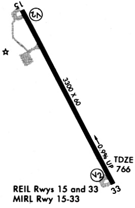
Runways
Runway Summary
| Runways: | 15/33 |
| Longest Runway: | 15/33 is 3304 ft (1007 m) long |
| Runways with an Instrument Approach: |
KOQW Airport Runway Details
| Runway 15/33 | 3304 ft x 60 ft (1007 m x 18 m) | |
| Runway Length Source: | 3RD PARTY SURVEY as of 08/10/2009 | |
| Surface: | Concrete - Good condition - No special surface treatment | |
| Runway Pavement Class: | 6 /R/C/W/U | |
| Runway Edge Lights: | Medium Intensity | |
Runway 15 |
Runway 33 |
|
Elevation: |
769.1 | 738.1 |
Latitude: |
42-03-15.0274N | 42-02-45.5139N |
Longitude: |
090-44-29.0385W | 090-44-10.3585W |
|
Runway True Alignment: |
155 | 335 |
Glide Path Angle: |
4.0 degrees | 4.0 degrees |
Traffic Pattern: |
Left | Left |
Runway Markings Type: |
Nonprecision Instrument | Nonprecision Instrument |
Runway Markings Condition: |
Fair | Fair |
Object at End: |
TREES | TREE |
Object Height: |
68 | 94 |
Distance from End: |
1878 | 2472 |
Object Centerline Offset: |
20 ft. right of centerline | 298 ft. left of centerline |
Visual Glide Slope Indicators: |
2-Light PAPI On Left Side Of Runway | 2-Light PAPI On Left Side Of Runway |
REIL: |
Yes | Yes |
Threshold Crossing Height: |
37 | 58 |
Services
Airframe Repair: |
Major |
Powerplant Repair: |
Major |
Bottled Oxygen: |
None |
Bulk Oxygen: |
None |
Fuel Available: |
100LL |
Landing Fees: |
No |
Parking: |
Hangars and tiedowns available |
Maps & Diagrams
KOQW Sectional
Flight Planning
at skyvector.com
at skyvector.com