Location
Latitude: |
42-53-12.7680N (42.88688) |
Longitude: |
090-14-11.9970W (-90.236666) |
Elevation: |
1170.7 feet MSL (357 m MSL) |
Magnetic Variation: |
2.3 W (as of April 2024 from WMM2020 model) |
Time Zone: |
UTC -6.0 (Standard Time) UTC -5.0 (Daylight Savings Time) |
From City: |
03 N.M. NW of Mineral Point, Wisconsin |
Found On: |
Chicago Chart |
FAA Region: |
AGL |
Contacts
Manager: |
Publicly owned: |
| REESE MEYER 3151 STATE RD 39 MINERAL POINT, WI 53565 608-553-7571 |
IOWA COUNTY 222 N. IOWA STREET DODGEVILLE, WI 53533 608-987-9931 |
Operations
Airport Status: |
Operational |
Facility Use: |
Public |
Type: |
Airport |
Activation Date: |
04/1962 |
Control tower: |
No |
Attendance (Months/Days/Hours): |
Months/Days/Hours ALL/MON-FRI/0800-1700 |
Boundary ARTCC: |
ZAU (Chicago) |
Responsible ARTCC: |
ZAU (Chicago) |
Lighting Schedule: |
SEE RMK |
Segmented Circle Indicator: |
No |
Traffic Pattern Altitude (MSL): |
2171 feet (662 m) |
NOTAMs Facility: |
MRJ |
NOTAM-D Service: |
Yes |
International Airport of Entry: |
No |
Customs Landing Rights: |
No |
Military Landing Rights: |
No |
Civil/Military Joint Use: |
No |
Based Aircraft
| Single Engine: | 26 |
| Multi Engine: | 2 |
| GA Helicopters: | 3 |
Annual Operations (as of 04/22/2021)
| Total Operations: | 6750 | |
| Air Taxi: | 750 | 11.1% |
| GA Local: | 2500 | 37.0% |
| GA Itinerant: | 3000 | 44.4% |
| Military Aircraft: | 500 | 7.4% |
Communications
| CTAF: | 122.800 |
| Unicom: | 122.800 |
| AWOS-3: | 118.525 (608-987-2157) |
- APCH/DEP SVC PRVDD BY CHICAGO ARTCC ON FREQS 133.95/281.4 (DUBUQUE RCAG).
Fixed Based Operators (FBOs) & Fuel
(Click on a business for detail)
Please help us keep this information up to date. This is a FREE SERVICE just like everything else on Airport Guide! If you see that a business needs to be added, modified, or deleted please fill out our Update Form.
To add, modify, or delete a business click here.
Please help us keep this information up to date. This is a FREE SERVICE just like everything else on Airport Guide! If you see that a business needs to be added, modified, or deleted please fill out our Update Form.
Area Code: 608 |
| Business Name | Frequency | Phone | Fuel Grade |
|---|---|---|---|
| Iowa County Airport
Update FBO info |
Unicom 122.8 | 987-9931, 987-2231 | 100LL, Mogas |
Flight Service Stations
| Primary | Alternate | |
| FSS on Field: | N | |
| FSS Name (ID): | Green Bay(GRB) | |
| Frequency: | ||
| Toll Free Phone: | 1-800-WX-BRIEF |
Instrument Procedures / Charts
FAA Terminal Procedures valid from 0901Z 03/21/24 to 0901Z 04/18/24.
There are various types of charts available for an airport. They are listed in the Page Type column. Here is a legend for those types:
APD - Airport Diagram
DP - Departure Procedure Charts
HOT - Hot Spots
IAP - Instrument Approach Procedure Charts
MIN - Minimums
STAR - Standard Terminal Arrival Charts
| Page Type | Page Name | Volume | Action Since Last Cycle |
|---|---|---|---|
| IAP | RNAV (GPS) RWY 04 | EC-3 | |
| IAP | RNAV (GPS) RWY 11 | EC-3 | |
| IAP | RNAV (GPS) RWY 22 | EC-3 | |
| IAP | RNAV (GPS) RWY 29 | EC-3 | |
| MIN | ALTERNATE MINIMUMS | EC-3 | |
| MIN | TAKEOFF MINIMUMS | EC-3 |
Terminal Procedures are only available for airports in several countries with more being added all the time. If you are looking for a specific country's charts, please send an email to support(at)airportguide.com stating the country name. This will be used to prioritize the implementation.
Navigation Aids (Navaids) near KMRJ
| Dist (NM) | ID | Morse Code | Name | Type | Freq | True Hdg | Mag Hdg |
|---|---|---|---|---|---|---|---|
| 0.5 | MRJ | _ _ . _ . . _ _ _ | Mineral Point | NDB | 365 | 80 | 82 |
| 24.9 | LNR | . _ . . _ . . _ . | Lone Rock | DME | 116.05 | 10 | 12 |
| 35.8 | DBQ | _ . . _ . . . _ _ . _ | Dubuque | VORTAC | 115.80 | 215 | 217 |
| 37.4 | DB | _ . . _ . . . | Zilom | NDB | 341 | 205 | 207 |
| 40.5 | MS | _ _ . . . | Monah | NDB | 400 | 74 | 77 |
| 42.3 | MSN | _ _ . . . _ . | Madison | VORTAC | 108.60 | 68 | 71 |
| 44.9 | DLL | _ . . . _ . . . _ . . | Dells | VORTAC | 117.00 | 27 | 30 |
| 46.3 | HBW | . . . . _ . . . . _ _ | Kickapoo | NDB | 251 | 354 | 356 |
| 53.6 | JVL | . _ _ _ . . . _ . _ . . | Janesville | VOR-DME | 114.30 | 111 | 114 |
| 55.1 | JVL | . _ _ _ . . . _ . _ . . | Janesville | NDB | 375 | 106 | 109 |
| 60.6 | RFD | . _ . . . _ . _ . . | Rockford | DME | 110.8 | 130 | 133 |
| 61.7 | UKN | . . _ _ . _ _ . | Waukon | DME | 116.6 | 292 | 294 |
| 63.4 | VOK | . . . _ _ _ _ _ . _ | Volk | TACAN | 110.40 | 359 | 361 |
| 63.6 | PLL | . _ _ . . _ . . . _ . . | Polo | VOR-DME | 111.20 | 150 | 153 |
| 65.5 | CMY | _ . _ . _ _ _ . _ _ | Mccoy | NDB | 412 | 344 | 346 |
| 68.4 | RF | . _ . . . _ . | Gilmy | NDB | 275 | 132 | 135 |
| 68.5 | FN | . . _ . _ . | Hillz | NDB | 517 | 185 | 187 |
| 68.5 | RYV | . _ . _ . _ _ . . . _ | Rock River | NDB | 371 | 74 | 77 |
| 71.5 | CVA | _ . _ . . . . _ . _ | Davenport | VORTAC | 113.80 | 188 | 190 |
| 73.2 | LVV | . _ . . . . . _ . . . _ | Lake Lawn | NDB | 404 | 98 | 101 |
Nearby Airports with Fuel
Notices to Airmen (NOTAMS)
Remarks
| A110-4 | BIRDS ON & INVOF ARPT. |
| A110-6 | FOR NOISE ABATEMENT PREFERED NO WIND RY IS RY 29. |
| A110-8 | FOR CD CTC CHICAGO ARTCC AT 630-906-8921. |
| A43-04 | VGSI AND RNAV GLIDEPATH NOT COINCIDENT. |
| A43-22 | VGSI AND RNAV GLIDEPATH NOT COINCIDENT. |
| A70-FUEL-10 | 0LL FUEL AVBL 24 HR SELF SVC. |
| A81-APT | ACTVT REIL RWY 11 & 29; PAPI RWY 04 & 22; MIRL RWY 04/22 - CTAF. MIRL RWY 11/29 PRESET ON LOW INTST, TO INCR INTST & ACTVT - CTAF. PAPI RWY 11 & 29 OPR CONSLY. |
Runways
Runway Summary
| Runways: | 04/22 11/29 |
| Longest Runway: | 11/29 is 5001 ft (1524 m) long |
| Runways with an Instrument Approach: |
KMRJ Airport Runway Details
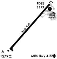
| Runway 04/22 | 3600 ft x 60 ft (1097 m x 18 m) | |
| Runway Length Source: | 3RD PARTY SURVEY as of 11/20/2019 | |
| Surface: | Asphalt - Good condition - No special surface treatment | |
| Runway Edge Lights: | Medium Intensity | |
Runway Weight Bearing Capacity (in thousands of pounds) |
||
| Single Wheel Landing Gear: | 12.5 | |
Runway 04 |
Runway 22 |
|
Elevation: |
1163.7 | 1170.6 |
Latitude: |
42-52-53.6343N | 42-53-20.7942N |
Longitude: |
090-14-10.6992W | 090-13-39.4977W |
|
Runway True Alignment: |
040 | 220 |
Glide Path Angle: |
3.0 degrees | 3.0 degrees |
Traffic Pattern: |
Left | Left |
Runway Markings Type: |
Nonprecision Instrument | Nonprecision Instrument |
Runway Markings Condition: |
Good | Good |
Visual Glide Slope Indicators: |
2-Light PAPI On Left Side Of Runway | 2-Light PAPI On Left Side Of Runway |
Threshold Crossing Height: |
31 | 30 |
| Runway 11/29 | 5001 ft x 75 ft (1524 m x 23 m) | |
| Runway Length Source: | 3RD PARTY SURVEY as of 11/20/2019 | |
| Surface: | Asphalt - Good condition - No special surface treatment | |
| Runway Edge Lights: | Medium Intensity | |
Runway 11 |
Runway 29 |
|
Elevation: |
1129.1 | 1163.9 |
Latitude: |
42-53-25.5079N | 42-53-08.0206N |
Longitude: |
090-14-55.5667W | 090-13-52.7629W |
|
Runway True Alignment: |
111 | 291 |
Glide Path Angle: |
3.0 degrees | 3.0 degrees |
Runway Markings Type: |
Nonprecision Instrument | Nonprecision Instrument |
Runway Markings Condition: |
Fair | Good |
Object at End: |
TREES | |
Object Height: |
16 | |
Distance from End: |
570 | |
Visual Glide Slope Indicators: |
2-Light PAPI On Left Side Of Runway | 2-Light PAPI On Left Side Of Runway |
REIL: |
Yes | Yes |
Threshold Crossing Height: |
43 | 44 |
Services
Airframe Repair: |
None |
Powerplant Repair: |
None |
Bottled Oxygen: |
None |
Bulk Oxygen: |
None |
Fuel Available: |
100LL |
Landing Fees: |
No |
Parking: |
Hangars and tiedowns available |
Maps & Diagrams
KMRJ Sectional
Flight Planning
at skyvector.com
at skyvector.com