Location
Latitude: |
42-41-21.6860N (42.689357) |
Longitude: |
090-26-39.8080W (-90.444391) |
Elevation: |
1025.2 feet MSL (312 m MSL) |
Magnetic Variation: |
2.1 W (as of April 2024 from WMM2020 model) |
Time Zone: |
UTC -6.0 (Standard Time) UTC -5.0 (Daylight Savings Time) |
From City: |
03 N.M. SE of Platteville, Wisconsin |
Found On: |
Chicago Chart |
FAA Region: |
AGL |
Contacts
Manager: |
Publicly owned: |
| BRITNEY BOXRUCKER, OPS SPECIALIST 5157 HWY 80 SOUTH PLATTEVILLE, WI 53818 608-348-3582 |
CITY OF PLATTEVILLE 75 N BONSON PLATTEVILLE, WI 53818 608-348-9741 |
Operations
Airport Status: |
Operational |
Facility Use: |
Public |
Type: |
Airport |
Activation Date: |
10/1965 |
Control tower: |
No |
Attendance (Months/Days/Hours): |
Months/Days/Hours ALL/ALL/0800-1700 |
Boundary ARTCC: |
ZAU (Chicago) |
Responsible ARTCC: |
ZAU (Chicago) |
Lighting Schedule: |
SEE RMK |
Segmented Circle Indicator: |
No |
Traffic Pattern Altitude (MSL): |
2025 feet (617 m) |
NOTAMs Facility: |
GRB |
NOTAM-D Service: |
Yes |
International Airport of Entry: |
No |
Customs Landing Rights: |
No |
Military Landing Rights: |
Yes |
Civil/Military Joint Use: |
No |
Based Aircraft
| Single Engine: | 18 |
| Multi Engine: | 1 |
| Jet Engine: | 2 |
Annual Operations (as of 04/22/2021)
| Total Operations: | 20550 | |
| Air Taxi: | 500 | 2.4% |
| GA Local: | 10000 | 48.7% |
| GA Itinerant: | 10000 | 48.7% |
| Military Aircraft: | 50 | 0.2% |
Communications
| CTAF: | 122.700 |
| Unicom: | 122.700 |
| AWOS-3: | 120.575 (608-348-3637) |
- APCH/DEP SVC PRVDD BY CHICAGO ARTCC ON FREQS 133.95/281.4 (DUBUQUE RCAG).
Fixed Based Operators (FBOs) & Fuel
(Click on a business for detail)
Please help us keep this information up to date. This is a FREE SERVICE just like everything else on Airport Guide! If you see that a business needs to be added, modified, or deleted please fill out our Update Form.
To add, modify, or delete a business click here.
Please help us keep this information up to date. This is a FREE SERVICE just like everything else on Airport Guide! If you see that a business needs to be added, modified, or deleted please fill out our Update Form.
Area Code: 608 |
| Business Name | Frequency | Phone | Fuel Grade |
|---|---|---|---|
| P & N Flight and Charter
Update FBO info |
Unicom 122.7 | 348-3580 | 100LL, Mogas |
Flight Service Stations
| Primary | Alternate | |
| FSS on Field: | N | |
| FSS Name (ID): | Green Bay(GRB) | |
| Frequency: | ||
| Toll Free Phone: | 1-800-WX-BRIEF |
Instrument Procedures / Charts
FAA Terminal Procedures valid from 0901Z 03/21/24 to 0901Z 04/18/24.
There are various types of charts available for an airport. They are listed in the Page Type column. Here is a legend for those types:
APD - Airport Diagram
DP - Departure Procedure Charts
HOT - Hot Spots
IAP - Instrument Approach Procedure Charts
MIN - Minimums
STAR - Standard Terminal Arrival Charts
| Page Type | Page Name | Volume | Action Since Last Cycle |
|---|---|---|---|
| IAP | RNAV (GPS) RWY 07 | EC-3 | |
| IAP | RNAV (GPS) RWY 15 | EC-3 | |
| IAP | RNAV (GPS) RWY 25 | EC-3 | |
| IAP | RNAV (GPS) RWY 33 | EC-3 | |
| MIN | ALTERNATE MINIMUMS | EC-3 | |
| MIN | TAKEOFF MINIMUMS | EC-3 |
Terminal Procedures are only available for airports in several countries with more being added all the time. If you are looking for a specific country's charts, please send an email to support(at)airportguide.com stating the country name. This will be used to prioritize the implementation.
Navigation Aids (Navaids) near KPVB
| Dist (NM) | ID | Morse Code | Name | Type | Freq | True Hdg | Mag Hdg |
|---|---|---|---|---|---|---|---|
| 15.3 | MRJ | _ _ . _ . . _ _ _ | Mineral Point | NDB | 365 | 38 | 40 |
| 20.9 | DBQ | _ . . _ . . . _ _ . _ | Dubuque | VORTAC | 115.80 | 214 | 216 |
| 23.0 | DB | _ . . _ . . . | Zilom | NDB | 341 | 197 | 199 |
| 38.8 | LNR | . _ . . _ . . _ . | Lone Rock | DME | 116.05 | 20 | 22 |
| 53.2 | MS | _ _ . . . | Monah | NDB | 400 | 64 | 67 |
| 55.7 | MSN | _ _ . . . _ . | Madison | VORTAC | 108.60 | 60 | 63 |
| 56.3 | FN | . . _ . _ . | Hillz | NDB | 517 | 177 | 179 |
| 58.2 | HBW | . . . . _ . . . . _ _ | Kickapoo | NDB | 251 | 4 | 6 |
| 58.9 | CVA | _ . _ . . . . _ . _ | Davenport | VORTAC | 113.80 | 181 | 183 |
| 59.6 | PLL | . _ _ . . _ . . . _ . . | Polo | VOR-DME | 111.20 | 136 | 138 |
| 59.6 | JVL | . _ _ _ . . . _ . _ . . | Janesville | VOR-DME | 114.30 | 97 | 100 |
| 59.6 | UKN | . . _ _ . _ _ . | Waukon | DME | 116.6 | 306 | 308 |
| 59.7 | DLL | _ . . . _ . . . _ . . | Dells | VORTAC | 117.00 | 29 | 31 |
| 61.7 | RFD | . _ . . . _ . _ . . | Rockford | DME | 110.8 | 116 | 119 |
| 62.1 | JVL | . _ _ _ . . . _ . _ . . | Janesville | NDB | 375 | 93 | 96 |
| 64.9 | DVN | _ . . . . . _ _ . | Davenport Municipal | VOT | 111.80 | 185 | 187 |
| 65.6 | BOZ | _ . . . _ _ _ _ _ . . | Whiteside | NDB | 254 | 153 | 155 |
| 68.0 | IIB | . . . . _ . . . | Wapsie | NDB | 206 | 258 | 260 |
| 68.9 | RF | . _ . . . _ . | Gilmy | NDB | 275 | 119 | 122 |
| 75.4 | CMY | _ . _ . _ _ _ . _ _ | Mccoy | NDB | 412 | 353 | 355 |
Nearby Airports with Fuel
Notices to Airmen (NOTAMS)
Remarks
| A110-1 | FOR CD IF UNA TO CTC ON FSS FREQ, CTC CHICAGO ARTCC AT 630-906-8921. |
| A70-FUEL-10 | 0LL 24 HR SELF SVC FUEL AVBL WITH CREDIT CARD. |
| A81-APT | ACTVT REIL RWY 15 & 33; PAPI RWY 7 & 25; MIRL RWY 07/25 & 15/33 - CTAF. |
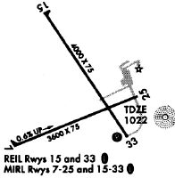
Runways
Runway Summary
| Runways: | 07/25 15/33 |
| Longest Runway: | 15/33 is 4000 ft (1219 m) long |
| Runways with an Instrument Approach: |
KPVB Airport Runway Details
| Runway 07/25 | 3600 ft x 75 ft (1097 m x 23 m) | |
| Runway Length Source: | 3RD PARTY SURVEY as of 09/16/2021 | |
| Surface: | Asphalt - Excellent condition - No special surface treatment | |
| Runway Edge Lights: | Medium Intensity | |
Runway Weight Bearing Capacity (in thousands of pounds) |
||
| Single Wheel Landing Gear: | 30.0 | |
| Dual Wheel Landing Gear: | 35.0 | |
Runway 07 |
Runway 25 |
|
Elevation: |
999.2 | 1022.0 |
Latitude: |
42-41-08.8443N | 42-41-22.0753N |
Longitude: |
090-27-04.2129W | 090-26-19.4707W |
|
Runway True Alignment: |
068 | 248 |
Glide Path Angle: |
3.0 degrees | 3.0 degrees |
Traffic Pattern: |
Left | Left |
Runway Markings Type: |
Nonprecision Instrument | Nonprecision Instrument |
Runway Markings Condition: |
Good | Good |
Object at End: |
ROAD | |
Object Height: |
31 | |
Distance from End: |
750 | |
Object Centerline Offset: |
330 ft. left of centerline | |
Visual Glide Slope Indicators: |
2-Light PAPI On Left Side Of Runway | 2-Light PAPI On Left Side Of Runway |
REIL: |
No | No |
Touchdown Lights: |
No | No |
Centerline Lights: |
No | No |
Threshold Crossing Height: |
20 | 28 |
| Runway 15/33 | 4000 ft x 75 ft (1219 m x 23 m) | |
| Runway Length Source: | 3RD PARTY SURVEY as of 09/16/2021 | |
| Surface: | Asphalt - Excellent condition - No special surface treatment | |
| Runway Edge Lights: | Medium Intensity | |
Runway Weight Bearing Capacity (in thousands of pounds) |
||
| Single Wheel Landing Gear: | 30.0 | |
| Dual Wheel Landing Gear: | 35.0 | |
Runway 15 |
Runway 33 |
|
Elevation: |
1023.5 | 1021.7 |
Latitude: |
42-41-43.4364N | 42-41-11.1400N |
Longitude: |
090-26-53.4066W | 090-26-22.5505W |
|
Runway True Alignment: |
145 | 325 |
Glide Path Angle: |
3.0 degrees | 3.0 degrees |
Runway Markings Type: |
Nonprecision Instrument | Nonprecision Instrument |
Runway Markings Condition: |
Good | Good |
Object Centerline Offset: |
330 ft. left of centerline | |
Visual Glide Slope Indicators: |
2-Light PAPI On Left Side Of Runway | 2-Light PAPI On Left Side Of Runway |
REIL: |
Yes | Yes |
Threshold Crossing Height: |
30 | 25 |
Services
Bottled Oxygen: |
None |
Bulk Oxygen: |
None |
Fuel Available: |
80, 100LL |
Landing Fees: |
No |
Parking: |
Tiedowns available |
Maps & Diagrams
KPVB Sectional
Flight Planning
at skyvector.com
at skyvector.com