Location
Latitude: |
35-40-05.2000N (35.668111) |
Longitude: |
095-56-54.7000W (-95.948528) |
Elevation: |
719.6 feet MSL (219 m MSL) |
Magnetic Variation: |
2.2 E (as of April 2024 from WMM2020 model) |
Time Zone: |
UTC -6.0 (Standard Time) UTC -5.0 (Daylight Savings Time) |
From City: |
03 N.M. N of Okmulgee, Oklahoma |
Found On: |
Dallas-Ft Worth Chart |
FAA Region: |
ASW |
Contacts
Manager: |
Publicly owned: |
| GARY UTLEY 500 EAST AIRPORT RD OKMULGEE, OK 74447 918-756-0412 |
CITY OF OKMULGEE 111 E. 4TH ST., P. O. BOX 250 OKMULGEE, OK 74447 918-756-4060 |
Operations
Airport Status: |
Operational |
Facility Use: |
Public |
Type: |
Airport |
Control tower: |
No |
Attendance (Months/Days/Hours): |
Months/Days/Hours ALL/MON-FRI/0800-1700 |
Boundary ARTCC: |
ZFW (Fort Worth) |
Responsible ARTCC: |
ZKC (Kansas City) |
Lighting Schedule: |
SEE RMK |
Segmented Circle Indicator: |
Yes |
Traffic Pattern Altitude (MSL): |
1720 feet (524 m) |
NOTAMs Facility: |
OKM |
NOTAM-D Service: |
Yes |
International Airport of Entry: |
No |
Customs Landing Rights: |
No |
Military Landing Rights: |
Yes |
Civil/Military Joint Use: |
No |
Based Aircraft
| Single Engine: | 19 |
| Multi Engine: | 1 |
Annual Operations (as of 07/29/2019)
| Total Operations: | 12410 | |
| GA Local: | 600 | 4.8% |
| GA Itinerant: | 11810 | 95.2% |
Communications
| CTAF: | 123.000 |
| Unicom: | 123.000 |
| Approach: | TULSA 119.85 119.85 |
| Departure: | TULSA 119.85 119.85 |
| AWOS-3PT: | 118.225 (918-756-9502) |
Fixed Based Operators (FBOs) & Fuel
(Click on a business for detail)
Please help us keep this information up to date. This is a FREE SERVICE just like everything else on Airport Guide! If you see that a business needs to be added, modified, or deleted please fill out our Update Form.
To add, modify, or delete a business click here.
Please help us keep this information up to date. This is a FREE SERVICE just like everything else on Airport Guide! If you see that a business needs to be added, modified, or deleted please fill out our Update Form.
Area Code: 918 |
| Business Name | Frequency | Phone | Fuel Grade |
|---|---|---|---|
| City of Okmulgee
Update FBO info |
Unicom 123.0 | 756-0412, -0413, -4060 | 100LL, Jet A |
Flight Service Stations
| Primary | Alternate | |
| FSS on Field: | N | |
| FSS Name (ID): | Mc Alester(MLC) | |
| Frequency: | ||
| Toll Free Phone: | 1-800-WX-BRIEF |
Instrument Procedures / Charts
FAA Terminal Procedures valid from 0901Z 03/21/24 to 0901Z 04/18/24.
There are various types of charts available for an airport. They are listed in the Page Type column. Here is a legend for those types:
APD - Airport Diagram
DP - Departure Procedure Charts
HOT - Hot Spots
IAP - Instrument Approach Procedure Charts
MIN - Minimums
STAR - Standard Terminal Arrival Charts
| Page Type | Page Name | Volume | Action Since Last Cycle |
|---|---|---|---|
| IAP | ILS OR LOC RWY 18 | SC-1 | |
| IAP | RNAV (GPS) RWY 18 | SC-1 | |
| IAP | RNAV (GPS) RWY 36 | SC-1 | |
| IAP | VOR-A | SC-1 | |
| MIN | ALTERNATE MINIMUMS | SC-1 | |
| MIN | TAKEOFF MINIMUMS | SC-1 |
Terminal Procedures are only available for airports in several countries with more being added all the time. If you are looking for a specific country's charts, please send an email to support(at)airportguide.com stating the country name. This will be used to prioritize the implementation.
Navigation Aids (Navaids) near OKM
| Dist (NM) | ID | Morse Code | Name | Type | Freq | True Hdg | Mag Hdg |
|---|---|---|---|---|---|---|---|
| 4.3 | OKM | _ _ _ _ . _ _ _ | Okmulgee | VOR-DME | 114.90 | 69 | 67 |
| 5.2 | OK | _ _ _ _ . _ | Preso | NDB | 388 | 359 | 357 |
| 15.2 | GNP | _ _ . _ . . _ _ . | Glenpool | DME | 110.6 | 356 | 354 |
| 16.1 | HET | . . . . . _ | Henryetta | NDB | 267 | 191 | 189 |
| 25.9 | TU | _ . . _ | Oillr | NDB | 338 | 6 | 4 |
| 31.9 | OWP | _ _ _ . _ _ . _ _ . | William Pogue | NDB | 362 | 341 | 339 |
| 32.1 | TUL | _ . . _ . _ . . | Tulsa Intl | VOT | 109.00 | 5 | 3 |
| 32.6 | TUL | _ . . _ . _ . . | Tulsa | VORTAC | 114.40 | 13 | 11 |
| 38.7 | GGU | _ _ . _ _ . . . _ | Prague | NDB | 314 | 256 | 254 |
| 42.3 | CUH | _ . _ . . . _ . . . . | Cushing | NDB | 242 | 288 | 286 |
| 42.5 | CQB | _ . _ . _ _ . _ _ . . . | Tilghman | NDB | 396 | 274 | 272 |
| 42.7 | SRE | . . . . _ . . | Seminole | NDB | 278 | 236 | 234 |
| 48.4 | TQH | _ _ _ . _ . . . . | Tahlequah | NDB | 215 | 70 | 68 |
| 49.8 | MLC | _ _ . _ . . _ . _ . | Mc Alester | TACAN | 112.00 | 170 | 168 |
| 50.3 | HN | . . . . _ . | Suybe | NDB | 264 | 255 | 253 |
| 52.6 | ML | _ _ . _ . . | Wampa | NDB | 344 | 173 | 171 |
| 58.6 | IQS | . . _ _ . _ . . . | Sallisaw | NDB | 520 | 105 | 103 |
| 62.8 | ADH | . _ _ . . . . . . | Ada | VOR-DME | 117.80 | 214 | 212 |
| 64.3 | SWO | . . . . _ _ _ _ _ | Stillwater | VOR-DME | 108.40 | 301 | 298 |
| 65.0 | SW | . . . . _ _ | Gabeh | NDB | 255 | 301 | 298 |
Nearby Airports with Fuel
Notices to Airmen (NOTAMS)
Remarks
| A110-1 | FLOCK OF MIGRATORY BIRDS & DEER ON & INVOF ARPT. |
| A110-2 | FOR CD CTC TULSA APP/DEP CTL AT 918-831-6714. |
| A70-FUEL-10 | 0LL 24 HR. AUTOMATED CREDIT CARD SYSTEM. |
| A81-APT | ACTVT MALSR RWY 18 AND INCR INTST - CTAF; PAPI RWY 18 & 36 ON CONSLY; MIRL RWY 18/36 ON LOW SS-SR, INCR INTST - CTAF. |
Runways
Runway Summary
| Runways: | 18/36 |
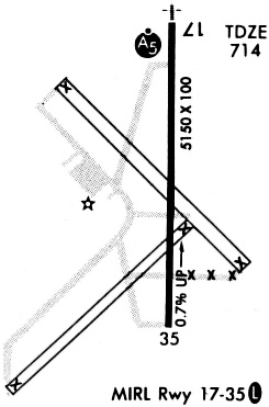
| Longest Runway: | 18/36 is 5150 ft (1570 m) long |
| Runways with an Instrument Approach: | 18 |
OKM Airport Runway Details
| Runway 18/36 | 5150 ft x 101 ft (1570 m x 31 m) | |
| Runway Length Source: | 3RD PARTY SURVEY as of 07/10/2012 | |
| Surface: | Concrete - Good condition - No special surface treatment | |
| Runway Edge Lights: | Medium Intensity | |
Runway Weight Bearing Capacity (in thousands of pounds) |
||
| Single Wheel Landing Gear: | 30.0 | |
| Dual Wheel Landing Gear: | 48.0 | |
| Dual Tandem Wheel Landing Gear: | 78.0 | |
Runway 18 |
Runway 36 |
|
Elevation: |
719.6 | 685.3 |
Latitude: |
35-40-30.7142N | 35-39-39.7838N |
Longitude: |
095-56-54.6145W | 095-56-54.8033W |
|
Runway True Alignment: |
180 | 000 |
ILS Type: |
ILS | |
Glide Path Angle: |
3.0 degrees | 3.0 degrees |
Traffic Pattern: |
Left | Left |
Runway Markings Type: |
Precision Instrument | Precision Instrument |
Runway Markings Condition: |
Good | Good |
Visual Glide Slope Indicators: |
4-Light PAPI On Left Side Of Runway | 4-Light PAPI On Left Side Of Runway |
Approach Light System: |
1,400 Foot Medium Intensity Approach Lighting System With Runway Alignment Indicator Lights | |
Threshold Crossing Height: |
51 | 40 |
Services
Airframe Repair: |
Minor |
Powerplant Repair: |
Minor |
Bottled Oxygen: |
High Pressure |
Bulk Oxygen: |
None |
Fuel Available: |
100LL, Jet A |
Landing Fees: |
No |
Parking: |
Hangars and tiedowns available |
Maps & Diagrams
OKM Sectional
Flight Planning
at skyvector.com
at skyvector.com