Location
Latitude: |
35-24-24.7670N (35.40688) |
Longitude: |
096-00-56.9980W (-96.015833) |
Elevation: |
849.0 feet MSL (259 m MSL) |
Magnetic Variation: |
2.2 E (as of April 2024 from WMM2020 model) |
Time Zone: |
UTC -6.0 (Standard Time) UTC -5.0 (Daylight Savings Time) |
From City: |
03 N.M. SW of Henryetta, Oklahoma |
Found On: |
Dallas-Ft Worth Chart |
FAA Region: |
ASW |
Contacts
Manager: |
Publicly owned: |
| RON CASEY PO BOX 608, 10249 LOBLOLLY RD. HENRYETTA, OK 74437 918-652-3348 |
CITY OF HENRYETTA CITY HALL, 115 S. 4TH ST HENRYETTA, OK 74437 918-652-3348 |
Operations
Airport Status: |
Operational |
Facility Use: |
Public |
Type: |
Airport |
Control tower: |
No |
Attendance (Months/Days/Hours): |
Months/Days/Hours Unattended |
Boundary ARTCC: |
ZFW (Fort Worth) |
Responsible ARTCC: |
ZFW (Fort Worth) |
Lighting Schedule: |
SEE RMK |
Segmented Circle Indicator: |
Yes |
Traffic Pattern Altitude (MSL): |
1849 feet (564 m) |
NOTAMs Facility: |
MLC |
NOTAM-D Service: |
Yes |
International Airport of Entry: |
No |
Customs Landing Rights: |
No |
Military Landing Rights: |
Yes |
Civil/Military Joint Use: |
No |
Based Aircraft
| Single Engine: | 3 |
Annual Operations (as of 03/23/2018)
| Total Operations: | 4010 | |
| GA Local: | 3000 | 74.8% |
| GA Itinerant: | 1000 | 24.9% |
| Military Aircraft: | 10 | 0.2% |
Communications
| CTAF: | 122.800 |
| Unicom: | 122.800 |
- APCH/DEP CTL SVC PRVDD BY FORT WORTH ARTCC (ZFW) ON FREQS 132.2/338.35 (MC ALESTER RCAG).
Fixed Based Operators (FBOs) & Fuel
(Click on a business for detail)
Please help us keep this information up to date. This is a FREE SERVICE just like everything else on Airport Guide! If you see that a business needs to be added, modified, or deleted please fill out our Update Form.
To add, modify, or delete a business click here.
Please help us keep this information up to date. This is a FREE SERVICE just like everything else on Airport Guide! If you see that a business needs to be added, modified, or deleted please fill out our Update Form.
Area Code: 918 |
| Business Name | Frequency | Phone | Fuel Grade |
|---|---|---|---|
| Henryetta Municipal Airport
Update FBO info |
Unicom 122.8 | 652-8634 | 100LL |
Flight Service Stations
| Primary | Alternate | |
| FSS on Field: | N | |
| FSS Name (ID): | Mc Alester(MLC) | |
| Frequency: | ||
| Toll Free Phone: | 1-800-WX-BRIEF |
Instrument Procedures / Charts
FAA Terminal Procedures valid from 0901Z 03/21/24 to 0901Z 04/18/24.
There are various types of charts available for an airport. They are listed in the Page Type column. Here is a legend for those types:
APD - Airport Diagram
DP - Departure Procedure Charts
HOT - Hot Spots
IAP - Instrument Approach Procedure Charts
MIN - Minimums
STAR - Standard Terminal Arrival Charts
| Page Type | Page Name | Volume | Action Since Last Cycle |
|---|---|---|---|
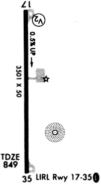
| IAP | RNAV (GPS) RWY 36 | SC-1 | |
| MIN | TAKEOFF MINIMUMS | SC-1 |
Terminal Procedures are only available for airports in several countries with more being added all the time. If you are looking for a specific country's charts, please send an email to support(at)airportguide.com stating the country name. This will be used to prioritize the implementation.
Navigation Aids (Navaids) near F10
| Dist (NM) | ID | Morse Code | Name | Type | Freq | True Hdg | Mag Hdg |
|---|---|---|---|---|---|---|---|
| 0.2 | HET | . . . . . _ | Henryetta | NDB | 267 | 146 | 144 |
| 18.7 | OKM | _ _ _ _ . _ _ _ | Okmulgee | VOR-DME | 114.90 | 23 | 21 |
| 21.2 | OK | _ _ _ _ . _ | Preso | NDB | 388 | 8 | 6 |
| 30.9 | GNP | _ _ . _ . . _ _ . | Glenpool | DME | 110.6 | 4 | 2 |
| 33.3 | SRE | . . . . _ . . | Seminole | NDB | 278 | 256 | 254 |
| 35.0 | GGU | _ _ . _ _ . . . _ | Prague | NDB | 314 | 281 | 279 |
| 35.4 | MLC | _ _ . _ . . _ . _ . | Mc Alester | TACAN | 112.00 | 161 | 159 |
| 37.8 | ML | _ _ . _ . . | Wampa | NDB | 344 | 165 | 163 |
| 41.9 | TU | _ . . _ | Oillr | NDB | 338 | 8 | 6 |
| 43.6 | CQB | _ . _ . _ _ . _ _ . . . | Tilghman | NDB | 396 | 296 | 294 |
| 45.4 | HN | . . . . _ . | Suybe | NDB | 264 | 273 | 271 |
| 46.5 | OWP | _ _ _ . _ _ . _ _ . | William Pogue | NDB | 362 | 351 | 349 |
| 47.0 | CUH | _ . _ . . . _ . . . . | Cushing | NDB | 242 | 308 | 306 |
| 48.0 | TUL | _ . . _ . _ . . | Tulsa Intl | VOT | 109.00 | 7 | 5 |
| 48.4 | ADH | . _ _ . . . . . . | Ada | VOR-DME | 117.80 | 221 | 219 |
| 48.6 | TUL | _ . . _ . _ . . | Tulsa | VORTAC | 114.40 | 13 | 11 |
| 58.3 | TQH | _ _ _ . _ . . . . | Tahlequah | NDB | 215 | 57 | 55 |
| 59.7 | IQS | . . _ _ . _ . . . | Sallisaw | NDB | 520 | 90 | 88 |
| 63.7 | HMY | . . . . _ _ _ . _ _ | Muldrow | NDB | 512 | 249 | 246 |
| 66.7 | TIK | _ . . _ . _ | Tinker | TACAN | 115.80 | 271 | 268 |
Nearby Airports with Fuel
Notices to Airmen (NOTAMS)
Remarks
| A110*G | THIS AIRPORT HAS BEEN SURVEYED BY THE NATIONAL GEODETIC SURVEY. |
| A110-1 | FOR CD CTC FORT WORTH ARTCC AT 817-858-7584. |
| A42-18 | MARKINGS SEVERELY FADED. |
| A42-36 | MARKINGS SEVERELY FADED. |
| A43-18 | OTS INDEFLY. |
| A81-APT | DUSK-DAWN. ACTVT MIRL RY 18/36 - CTAF. |
Runways
Runway Summary
| Runways: | 18/36 |
| Longest Runway: | 18/36 is 3501 ft (1067 m) long |
| Runways with an Instrument Approach: |
F10 Airport Runway Details
| Runway 18/36 | 3501 ft x 50 ft (1067 m x 15 m) | |
| Surface: | Asphalt - Fair condition - No special surface treatment | |
| Runway Edge Lights: | Medium Intensity | |
Runway Weight Bearing Capacity (in thousands of pounds) |
||
| Single Wheel Landing Gear: | 12.0 | |
Runway 18 |
Runway 36 |
|
Elevation: |
830.0 | 849.0 |
Latitude: |
35-24-42.0630N | 35-24-07.4330N |
Longitude: |
096-00-56.9460W | 096-00-57.0200W |
|
Runway True Alignment: |
180 | 360 |
Glide Path Angle: |
3.5 degrees | 0.0 degrees |
Traffic Pattern: |
Left | Left |
Runway Markings Type: |
Basic | Nonprecision Instrument |
Runway Markings Condition: |
Poor | Poor |
Object at End: |
TREES | TREES |
Object Height: |
41 | 28 |
Distance from End: |
253 | 257 |
Object Centerline Offset: |
18 ft. left of centerline | 317 ft. left of centerline |
Visual Glide Slope Indicators: |
Pulsating/Steady Burning VASI On Left Side Of Runway | |
Threshold Crossing Height: |
45 |
Services
Airframe Repair: |
Major |
Powerplant Repair: |
Major |
Bottled Oxygen: |
None |
Bulk Oxygen: |
None |
Fuel Available: |
100LL, Jet A |
Landing Fees: |
No |
Parking: |
Hangars and tiedowns available |
Maps & Diagrams
F10 Sectional
Flight Planning
at skyvector.com
at skyvector.com