Location
Latitude: |
41-19-46.9230N (41.329701) |
Longitude: |
086-39-52.5940W (-86.664609) |
Elevation: |
685.3 feet MSL (209 m MSL) |
Magnetic Variation: |
4.8 W (as of April 2024 from WMM2020 model) |
Time Zone: |
UTC -6.0 (Standard Time) UTC -5.0 (Daylight Savings Time) |
From City: |
03 N.M. NW of Knox, Indiana |
Found On: |
Chicago Chart |
FAA Region: |
AGL |
Contacts
Manager: |
Publicly owned: |
| PAM BEHARRY 1795 N 200 E KNOX, IN 46534 574-772-5001 |
STARKE COUNTY ARPT AUTH 1795 N. 200 E. KNOX, IN 46534 574-772-5001 |
Operations
Airport Status: |
Operational |
Facility Use: |
Public |
Type: |
Airport |
Activation Date: |
04/1977 |
Control tower: |
No |
Attendance (Months/Days/Hours): |
Months/Days/Hours ALL/ALL/0800-1800 |
Boundary ARTCC: |
ZAU (Chicago) |
Responsible ARTCC: |
ZAU (Chicago) |
Lighting Schedule: |
SEE RMK |
Segmented Circle Indicator: |
Yes |
Traffic Pattern Altitude (MSL): |
1685 feet (514 m) |
NOTAMs Facility: |
HUF |
NOTAM-D Service: |
Yes |
International Airport of Entry: |
No |
Customs Landing Rights: |
No |
Military Landing Rights: |
Yes |
Based Aircraft
| Single Engine: | 25 |
| Multi Engine: | 1 |
| GA Helicopters: | 2 |
Annual Operations (as of 12/31/2019)
| Total Operations: | 24520 | |
| Air Taxi: | 735 | 3.0% |
| GA Local: | 8336 | 34.0% |
| GA Itinerant: | 15449 | 63.0% |
Communications
| CTAF: | 122.800 |
| Unicom: | 122.800 |
| Approach: | SOUTH BEND 132.05 132.05 CHICAGO ARTCC |
| Departure: | SOUTH BEND 132.05 132.05 CHICAGO ARTCC |
| AWOS-3: | 135.775 (574-772-2041) |
- APCH/DEP SVC PRVDD BY CHICAGO ARTCC ON FREQS 135.9/314.0 (GOSHEN RCAG) WHEN SOUTH BEND APCH CTL CLSD.
Fixed Based Operators (FBOs) & Fuel
(Click on a business for detail)
Please help us keep this information up to date. This is a FREE SERVICE just like everything else on Airport Guide! If you see that a business needs to be added, modified, or deleted please fill out our Update Form.
To add, modify, or delete a business click here.
Please help us keep this information up to date. This is a FREE SERVICE just like everything else on Airport Guide! If you see that a business needs to be added, modified, or deleted please fill out our Update Form.
Area Code: 219 |
| Business Name | Frequency | Phone | Fuel Grade |
|---|---|---|---|
| GPI Aviation, Inc.
Update FBO info |
Unicom 122.8 | 772-5001 | 80, 100LL, Mogas |
| Starke County Airport Authority
Website Update FBO info |
122.8 | 219-772-5001 TollFree 877-772-5002 |
80, 100LL, Mogas |

|
 Air BP |
80/87 - 2.40 USD per gallon on 10/9/01 |
24 Hour Self Serve Credit Card Pumps |
|
|
Air BP |
100LL - 1.80 USD per gallon on 10/9/01 |
24 Hour Self Serve Credit Card Pumps |
|
|
Air BP |
MOGAS - 1.70 USD per gallon on 10/9/01 |
Pumps Requiring Line Service 92+ Octane |
Flight Service Stations
| Primary | Alternate | |
| FSS on Field: | N | |
| FSS Name (ID): | Terre Haute(HUF) | |
| Frequency: | ||
| Toll Free Phone: | 1-800-WX-BRIEF |
Instrument Procedures / Charts
FAA Terminal Procedures valid from 0901Z 03/21/24 to 0901Z 04/18/24.
There are various types of charts available for an airport. They are listed in the Page Type column. Here is a legend for those types:
APD - Airport Diagram
DP - Departure Procedure Charts
HOT - Hot Spots
IAP - Instrument Approach Procedure Charts
MIN - Minimums
STAR - Standard Terminal Arrival Charts
| Page Type | Page Name | Volume | Action Since Last Cycle |
|---|---|---|---|
| IAP | RNAV (GPS) RWY 18 | EC-2 | |
| MIN | ALTERNATE MINIMUMS | EC-2 | |
| MIN | TAKEOFF MINIMUMS | EC-2 |
Terminal Procedures are only available for airports in several countries with more being added all the time. If you are looking for a specific country's charts, please send an email to support(at)airportguide.com stating the country name. This will be used to prioritize the implementation.
Navigation Aids (Navaids) near KOXI
| Dist (NM) | ID | Morse Code | Name | Type | Freq | True Hdg | Mag Hdg |
|---|---|---|---|---|---|---|---|
| 0.8 | OXI | _ _ _ _ . . _ . . | Knox | DME | 115.6 | 123 | 128 |
| 11.2 | IUL | . . . . _ . _ . . | La Porte | NDB | 356 | 334 | 339 |
| 12.0 | VP | . . . _ . _ _ . | Sedly | NDB | 212 | 307 | 312 |
| 14.3 | CPB | _ . _ . . _ _ . _ . . . | Culver | NDB | 391 | 118 | 123 |
| 14.4 | RWN | . _ . . _ _ _ . | Winamac/Dcmsnd | NDB | 335 | 169 | 174 |
| 30.2 | SB | . . . _ . . . | Misha | NDB | 341 | 41 | 46 |
| 30.6 | GIJ | _ _ . . . . _ _ _ | Gipper | VORTAC | 115.40 | 30 | 35 |
| 30.9 | GSH | _ _ . . . . . . . . | Goshen | VORTAC | 113.70 | 67 | 72 |
| 42.2 | CGT | _ . _ . _ _ . _ | Chicago Heights | VORTAC | 114.20 | 285 | 289 |
| 47.2 | GUS | _ _ . . . _ . . . | Grissom | VORTAC | 108.45 | 150 | 155 |
| 49.9 | BVT | _ . . . . . . _ _ | Boiler | VORTAC | 115.10 | 201 | 206 |
| 50.3 | BE | _ . . . . | Mally | NDB | 397 | 18 | 23 |
| 50.9 | EON | . _ _ _ _ . | Peotone | VORTAC | 113.20 | 266 | 270 |
| 51.9 | IWH | . . . _ _ . . . . | Wabash | NDB | 329 | 130 | 135 |
| 52.3 | MX | _ _ _ . . _ | Kedzi | NDB | 248 | 298 | 302 |
| 52.9 | OLK | _ _ _ . _ . . _ . _ | Webster Lake | VOR | 110.40 | 95 | 100 |
| 54.6 | ELX | . . _ . . _ . . _ | Keeler | VOR-DME | 116.60 | 26 | 31 |
| 55.4 | OKK | _ _ _ _ . _ _ . _ | Kokomo | TACAN | 113.50 | 150 | 155 |
| 55.7 | IKK | . . _ . _ _ . _ | Kankakee | DME | 111.6 | 254 | 258 |
| 56.0 | MDW | _ _ _ . . . _ _ | Chicago Midway | VOT | 111.00 | 299 | 303 |
Nearby Airports with Fuel
Notices to Airmen (NOTAMS)
Remarks
| A110-1 | FOR CD CTC SOUTH BEND APCH AT 574-251-2609. WHEN SOUTH BEND APCH CLSD, FOR CD CTC CHICAGO ARTCC AT 630-906-8921. |
| A110-2 | SELF SERVICE FUEL AVBL. |
| A17 | UNATNDD EASTER, MEMORIAL DAY, JULY 4TH, LABOR DAY, THANKSGIVING, CHRISTMAS EVE & DAY UNLESS APREQ. |
| A30-09/27 | BOUNDARY MKD BY YELLOW CONES. |
| A42-09 | DSPLCD THR MKD BY YELLOW CONES. |
| A57-09 | APCH SLOPE 20:1 FM DSPLCD THR; 65 FT TREES 270 FT FM RWY END 100 FT L. |
| A58-18 | 10 FT CROPS 170 FT R OF RWY END |
| A58-36 | 10 FT CROPS 160 FT L OF RWY END |
| A81-APT | ACTVT REIL RWY 18 & 36 - CTAF; PAPI RWY 18 & 36 ON CONSLY. |
| E111 | PROVIDED ALL TFC PAT OPERS ARE CONDUCTED ON THE W SIDE OF N/S RWY & ON THE N SIDE OF E/W RWY. |
Runways
Runway Summary
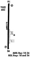
| Runways: | 09/27 18/36 |
| Longest Runway: | 18/36 is 5001 ft (1524 m) long |
| Runways with an Instrument Approach: |
KOXI Airport Runway Details
| Runway 09/27 | 3096 ft x 145 ft (944 m x 44 m) | |
| Runway Length Source: | 3RD PARTY SURVEY as of 07/16/2020 | |
| Surface: | Turf - Good condition - No special surface treatment | |
Runway 09 |
Runway 27 |
|
Elevation: |
679.9 | 681.4 |
Latitude: |
41-19-47.7361N | 41-19-47.4907N |
Longitude: |
086-40-26.6430W | 086-39-46.0662W |
|
Runway True Alignment: |
090 | 270 |
Glide Path Angle: |
0.0 degrees | 0.0 degrees |
Object at End: |
CROPS | BLDG |
Object Height: |
10 | 28 |
Object Centerline Offset: |
0 ft. left and right of centerline | 190 ft. left of centerline |
Threshold Elevation: |
680.4 | |
Displaced Threshold: |
285 | |
Threshold Latitude: |
41-19-47.7131N | |
Threshold Longitude: |
086-40-22.9067W |
| Runway 18/36 | 5001 ft x 75 ft (1524 m x 23 m) | |
| Runway Length Source: | 3RD PARTY SURVEY as of 07/16/2020 | |
| Surface: | Turf - Good condition - No special surface treatment | |
| Runway Edge Lights: | Medium Intensity | |
Runway Weight Bearing Capacity (in thousands of pounds) |
||
| Single Wheel Landing Gear: | 30.0 | |
Runway 18 |
Runway 36 |
|
Elevation: |
683.3 | 685.3 |
Latitude: |
41-20-11.2007N | 41-19-21.7907N |
Longitude: |
086-39-44.0947W | 086-39-44.0579W |
|
Runway True Alignment: |
180 | 360 |
Glide Path Angle: |
3.0 degrees | 3.0 degrees |
Traffic Pattern: |
Right | Left |
Runway Markings Type: |
Nonprecision Instrument | Nonprecision Instrument |
Runway Markings Condition: |
Good | Good |
Object at End: |
CROPS | CROPS |
Object Height: |
10 | 10 |
Object Centerline Offset: |
0 ft. left and right of centerline | 190 ft. left of centerline |
Visual Glide Slope Indicators: |
2-Light PAPI On Left Side Of Runway | 2-Light PAPI On Left Side Of Runway |
REIL: |
Yes | Yes |
Threshold Crossing Height: |
27 | 40 |
Services
Airframe Repair: |
Major |
Powerplant Repair: |
Major |
Bottled Oxygen: |
High Pressure |
Fuel Available: |
100LL, Jet A |
Landing Fees: |
No |
Parking: |
Hangars and tiedowns available |
Maps & Diagrams
KOXI Sectional
Flight Planning
at skyvector.com
at skyvector.com