Location
Latitude: |
41-07-57.4385N (41.132622) |
Longitude: |
088-26-19.1230W (-88.438645) |
Elevation: |
632.0 feet MSL (193 m MSL) |
Magnetic Variation: |
3.5 W (as of April 2024 from WMM2020 model) |
Time Zone: |
UTC -6.0 (Standard Time) UTC -5.0 (Daylight Savings Time) |
From City: |
03 N.M. N of Dwight, Illinois |
Found On: |
Chicago Chart |
FAA Region: |
AGL |
Contacts
Manager: |
Privately owned: |
| DAN RIBORDY PO BOX 214 DWIGHT, IL 60420 (815) 374-4319 |
DWIGHT AERO SERVICE 6034 E CAMBRIDGE AVENUE SCOTTSDALE, AZ 85257 (602) 319-3319 |
Operations
Airport Status: |
Operational |
Facility Use: |
Public |
Type: |
Airport |
Activation Date: |
04/1962 |
Control tower: |
No |
Attendance (Months/Days/Hours): |
Months/Days/Hours Unattended |
Boundary ARTCC: |
ZAU (Chicago) |
Responsible ARTCC: |
ZAU (Chicago) |
Lighting Schedule: |
SEE RMK |
Segmented Circle Indicator: |
No |
Traffic Pattern Altitude (MSL): |
1632 feet (497 m) |
NOTAMs Facility: |
IKK |
NOTAM-D Service: |
Yes |
International Airport of Entry: |
No |
Customs Landing Rights: |
No |
Military Landing Rights: |
No |
Civil/Military Joint Use: |
No |
Based Aircraft
| Single Engine: | 9 |
| Ultralights: | 2 |
Annual Operations (as of 07/31/2022)
| Total Operations: | 2000 | |
| GA Local: | 1350 | 67.5% |
| GA Itinerant: | 650 | 32.5% |
Communications
| CTAF: | 122.800 |
| Unicom: | 122.800 |
- APCH/DEP SVC PRVDD BY CHICAGO ARTCC (ZAU) ON FREQS 123.75/259.1 (MAZON RCAG).
Fixed Based Operators (FBOs) & Fuel
(Click on a business for detail)
Please help us keep this information up to date. This is a FREE SERVICE just like everything else on Airport Guide! If you see that a business needs to be added, modified, or deleted please fill out our Update Form.
To add, modify, or delete a business click here.
Please help us keep this information up to date. This is a FREE SERVICE just like everything else on Airport Guide! If you see that a business needs to be added, modified, or deleted please fill out our Update Form.
Area Code: 815 |
| Business Name | Frequency | Phone | Fuel Grade |
|---|---|---|---|
| Dwight Aero Service
Update FBO info |
Unicom 122.8 | 584-2486 | 100LL |
Flight Service Stations
| Primary | Alternate | |
| FSS on Field: | N | |
| FSS Name (ID): | Kankakee(IKK) | |
| Frequency: | ||
| Toll Free Phone: | 1-800-WX-BRIEF |
Instrument Procedures / Charts
| Page Type | Page Name | Volume | Action Since Last Cycle |
|---|
Terminal Procedures are only available for airports in several countries with more being added all the time. If you are looking for a specific country's charts, please send an email to support(at)airportguide.com stating the country name. This will be used to prioritize the implementation.
Navigation Aids (Navaids) near KDTG
| Dist (NM) | ID | Morse Code | Name | Type | Freq | True Hdg | Mag Hdg |
|---|---|---|---|---|---|---|---|
| 23.0 | PNT | . _ _ . _ . _ | Pontiac | VOR-DME | 109.60 | 215 | 218 |
| 23.3 | OIX | _ _ _ . . _ . . _ | Ottawa | NDB | 266 | 306 | 309 |
| 25.2 | IK | . . _ . _ | Lukow | NDB | 272 | 105 | 109 |
| 25.4 | JOT | . _ _ _ _ _ _ _ | Joliet | VOR-DME | 112.30 | 12 | 16 |
| 26.8 | IKK | . . _ . _ _ . _ | Kankakee | DME | 111.6 | 97 | 101 |
| 30.4 | EON | . _ _ _ _ . | Peotone | VORTAC | 113.20 | 74 | 78 |
| 35.3 | RBS | . _ . _ . . . . . . | Roberts | VOR-DME | 116.80 | 159 | 163 |
| 39.6 | LH | . _ . . . . . . | Egrow | NDB | 334 | 210 | 213 |
| 44.4 | HK | . . . . _ . _ | Ermin | NDB | 332 | 37 | 41 |
| 45.1 | BMI | _ . . . _ _ . . | Bloomington | DME | 108.2 | 209 | 212 |
| 45.2 | CGT | _ . _ . _ _ . _ | Chicago Heights | VORTAC | 114.20 | 59 | 63 |
| 45.6 | DPA | _ . . . _ _ . . _ | Dupage | VOR-DME | 108.40 | 4 | 8 |
| 49.7 | MX | _ _ _ . . _ | Kedzi | NDB | 248 | 42 | 46 |
| 49.9 | MDW | _ _ _ . . . _ _ | Chicago Midway | VOT | 111.00 | 37 | 41 |
| 52.0 | BDF | _ . . . _ . . . . _ . | Bradford | VORTAC | 114.70 | 272 | 275 |
| 53.4 | ME | _ _ . | Deana | NDB | 350 | 20 | 24 |
| 56.6 | ORD | _ _ _ . _ . _ . . | Chicago O'hare | VOR-DME | 113.90 | 24 | 28 |
| 57.0 | GCO | _ _ . _ . _ . _ _ _ | Chicago | DME | 108.25 | 24 | 28 |
| 61.2 | PI | . _ _ . . . | Tungg | NDB | 356 | 239 | 242 |
| 64.3 | DNV | _ . . _ . . . . _ | Danville | VORTAC | 111.00 | 141 | 145 |
Nearby Airports with Fuel
Notices to Airmen (NOTAMS)
Remarks
| A11 | C/O DEANNA SCHAFF (MAJORITY SHARE HOLDER) EMAIL ADDRESS: DEANNASCHAFF@AOL.COM (ALL LOWER CASE). |
| A110-1 | FOR CD CTC CHICAGO ARTCC AT 630-906-8921. |
| A15 | EMAIL ADDRESS: DTGAERO@GMAIL.COM (ALL LOWER CASE) |
| A32-09/27 | 21' ASPH STRIP CENTERED ON 100' TURF STRIP. |
| A40-09/27 | RY 09/27 NSTD LIRL; NOT FAA APPROVED L-800 SERIES. SPACING & INTST OF LGTS VARY. |
| A42-09 | 09/27 NSTD MKGS DUE TO NARROW WIDTH. |
| A57-27 | APCH RATIO TO DSPLCD THR 40:1; APCH RATIO TO DSPLCD THR OVER 16 FT BLDG 236 FT R OF CNTRLN 1 FT BACK FM DSPLCD THR 0:1. |
| A58-27 | 15 FT RD 185 FT FM RY END 0B CNTRLN; NUMEROUS BLDGS R OF CNTRLN +299 FT IN FRONT 164 FT IN BACK OF THE RY END WITH MAX TOP AT 20 FT 237 FT RIGHT OF CNTRLN & 106 FT IN FRONT OF RY END. |
| A81-APT | FOR LIRL RY 09/27 AFTER 2200 CALL 815-258-8218. |
| A81-BCN | FOR ROTG BCN CALL 815-258-8218. |
Runways
Runway Summary
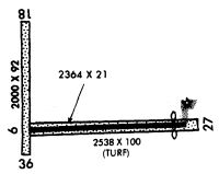
| Runways: | 09/27 18/36 |
| Longest Runway: | 09/27 is 2364 ft (721 m) long |
| Runways with an Instrument Approach: |
KDTG Airport Runway Details
| Runway 09/27 | 2364 ft x 21 ft (721 m x 6 m) | |
| Surface: | Asphalt/Turf - Good condition - No special surface treatment | |
| Runway Edge Lights: | Non-standard lighting system Intensity | |
Runway 09 |
Runway 27 |
|
Elevation: |
629.0 | 623.0 |
Latitude: |
41-07-57.0330N | 41-07-57.8440N |
Longitude: |
088-26-34.5610W | 088-26-03.6850W |
|
Runway True Alignment: |
088 | 268 |
Glide Path Angle: |
0.0 degrees | 0.0 degrees |
Traffic Pattern: |
Left | Left |
Runway Markings Type: |
Nonstandard (other than numbers only) | Nonstandard (other than numbers only) |
Runway Markings Condition: |
Good | Good |
Object at End: |
BLDG | |
Object Height: |
17 | |
Distance from End: |
389 | |
Object Centerline Offset: |
332 ft. right of centerline | |
REIL: |
No | |
Touchdown Lights: |
No | No |
Centerline Lights: |
No | No |
Threshold Elevation: |
623.7 | |
Displaced Threshold: |
300 | |
Threshold Latitude: |
41-07-57.7500N | |
Threshold Longitude: |
088-26-07.6000W |
| Runway 18/36 | 1900 ft x 100 ft (579 m x 30 m) | |
| Runway Length Source: | OWNER as of 04/27/2011 | |
| Surface: | Asphalt/Turf - Good condition - No special surface treatment | |
Runway 18 |
Runway 36 |
|
Glide Path Angle: |
0.0 degrees | 0.0 degrees |
Traffic Pattern: |
Left | Left |
Runway Markings Type: |
None | None |
Object Centerline Offset: |
332 ft. right of centerline | |
REIL: |
No | No |
Touchdown Lights: |
No | No |
Centerline Lights: |
No | No |
Services
Airframe Repair: |
Major |
Powerplant Repair: |
Major |
Bottled Oxygen: |
High Pressure / Low Pressure |
Bulk Oxygen: |
High Pressure / Low Pressure |
Fuel Available: |
100LL, Jet A |
Landing Fees: |
No |
Parking: |
Hangars and tiedowns available |
Maps & Diagrams
KDTG Sectional
Flight Planning
at skyvector.com
at skyvector.com