Location
Latitude: |
40-28-37.6000N (40.477111) |
Longitude: |
088-54-57.3000W (-88.915917) |
Elevation: |
871.4 feet MSL (266 m MSL) |
Magnetic Variation: |
3 W (as of April 2024 from WMM2020 model) |
Time Zone: |
UTC -6.0 (Standard Time) UTC -5.0 (Daylight Savings Time) |
From City: |
03 N.M. E of Bloomington/Normal, Illinois |
Found On: |
Chicago Chart |
FAA Region: |
AGL |
Contacts
Manager: |
Publicly owned: |
| CARL G. OLSON 3201 CIRA DRIVE BLOOMINGTON, IL 61704 309-663-7383 |
BLOOMINGTON NORMAL ARPT AUTH 3201 CIRA DRIVE BLOOMINGTON, IL 61704 309-663-7383 |
Operations
Airport Status: |
Operational |
Facility Use: |
Public |
Type: |
Airport |
Activation Date: |
04/1940 |
Control tower: |
Yes |
Attendance (Months/Days/Hours): |
Months/Days/Hours ALL/ALL/0400L-2400L |
Boundary ARTCC: |
ZAU (Chicago) |
Responsible ARTCC: |
ZKC (Kansas City) |
Lighting Schedule: |
SEE RMK |
Segmented Circle Indicator: |
No |
Traffic Pattern Altitude (MSL): |
1871 feet (570 m) |
NOTAMs Facility: |
BMI |
NOTAM-D Service: |
Yes |
International Airport of Entry: |
No |
Customs Landing Rights: |
No |
Military Landing Rights: |
Yes |
Civil/Military Joint Use: |
No |
Aircraft Rescue and Firefighting: |
Class I ARFF Index: B Air Carrier Service: Scheduled Certification Date: 05/1973 |
Based Aircraft
| Single Engine: | 69 |
| Multi Engine: | 1 |
| Jet Engine: | 7 |
| GA Helicopters: | 1 |
Annual Operations (as of 12/31/2021)
| Total Operations: | 23199 | |
| Commercial: | 4079 | 17.6% |
| Air Taxi: | 1812 | 7.8% |
| GA Local: | 5946 | 25.6% |
| GA Itinerant: | 10879 | 46.9% |
| Military Aircraft: | 483 | 2.1% |
Communications
| CTAF: | 124.600 |
| Unicom: | 122.950 |
| Tower: | BLOOMINGTON 124.6 269.575 Hrs: 0600-2200 |
| Ground: | 121.65 |
| Approach: | SAINT LOUIS 128.725 128.725 |
| Departure: | SAINT LOUIS 128.725 128.725 |
| ATIS: | 135.35 Hrs: 24 |
| AWOS-3PT: | 135.35 (309-661-9478) |
| EMERG: | 121.5 |
Fixed Based Operators (FBOs) & Fuel
(Click on a business for detail)
Please help us keep this information up to date. This is a FREE SERVICE just like everything else on Airport Guide! If you see that a business needs to be added, modified, or deleted please fill out our Update Form.
To add, modify, or delete a business click here.
Please help us keep this information up to date. This is a FREE SERVICE just like everything else on Airport Guide! If you see that a business needs to be added, modified, or deleted please fill out our Update Form.
Area Code: 309 |
| Business Name | Frequency | Phone | Fuel Grade |
|---|---|---|---|
| Bloomington Avionics
Update FBO info |
663-2713, 800-613-2713 | ||
| Image Air
Update FBO info |
Unicom 122.95 | 663-2303 | 100LL, Jet A |
Flight Service Stations
| Primary | Alternate | |
| FSS on Field: | N | |
| FSS Name (ID): | Kankakee(IKK) | |
| Frequency: | ||
| Toll Free Phone: | 1-800-WX-BRIEF |
Instrument Procedures / Charts
FAA Terminal Procedures valid from 0901Z 03/21/24 to 0901Z 04/18/24.
There are various types of charts available for an airport. They are listed in the Page Type column. Here is a legend for those types:
APD - Airport Diagram
DP - Departure Procedure Charts
HOT - Hot Spots
IAP - Instrument Approach Procedure Charts
MIN - Minimums
STAR - Standard Terminal Arrival Charts
| Page Type | Page Name | Volume | Action Since Last Cycle |
|---|---|---|---|
| APD | AIRPORT DIAGRAM | EC-3 | |
| HOT | HOT SPOT | EC-3 | |
| IAP | ILS OR LOC RWY 02 | EC-3 | |
| IAP | ILS OR LOC RWY 20 | EC-3 | |
| IAP | ILS OR LOC RWY 29 | EC-3 | |
| IAP | ILS RWY 20 (CAT II) | EC-3 | |
| IAP | LOC BC RWY 11 | EC-3 | |
| IAP | RNAV (GPS) RWY 02 | EC-3 | |
| IAP | RNAV (GPS) RWY 11 | EC-3 | |
| IAP | RNAV (GPS) RWY 20 | EC-3 | |
| IAP | RNAV (GPS) RWY 29 | EC-3 | |
| LAH | LAHSO | EC-3 | |
| MIN | ALTERNATE MINIMUMS | EC-3 | |
| MIN | TAKEOFF MINIMUMS | EC-3 |
Terminal Procedures are only available for airports in several countries with more being added all the time. If you are looking for a specific country's charts, please send an email to support(at)airportguide.com stating the country name. This will be used to prioritize the implementation.
Navigation Aids (Navaids) near BMI
| Dist (NM) | ID | Morse Code | Name | Type | Freq | True Hdg | Mag Hdg |
|---|---|---|---|---|---|---|---|
| 0.7 | BMI | _ . . . _ _ . . | Bloomington | DME | 108.2 | 287 | 290 |
| 5.3 | LH | . _ . . . . . . | Egrow | NDB | 334 | 20 | 23 |
| 22.3 | PNT | . _ _ . _ . _ | Pontiac | VOR-DME | 109.60 | 21 | 24 |
| 27.1 | AAA | . _ . _ . _ | Abraham | NDB | 329 | 225 | 228 |
| 31.8 | PI | . _ _ . . . | Tungg | NDB | 356 | 284 | 287 |
| 34.8 | RBS | . _ . _ . . . . . . | Roberts | VOR-DME | 116.80 | 79 | 82 |
| 36.7 | DEC | _ . . . _ . _ . | Akley | FAN MARKER | 169 | 172 | |
| 39.5 | CMI | _ . _ . _ _ . . | Champaign | VORTAC | 110.00 | 131 | 134 |
| 41.2 | DE | _ . . . | Elwin | NDB | 275 | 182 | 185 |
| 41.8 | PIA | . _ _ . . . . _ | Peoria | VORTAC | 115.20 | 287 | 290 |
| 44.5 | AXC | . _ _ . . _ _ . _ . | Adders | VORTAC | 117.20 | 176 | 179 |
| 45.5 | CM | _ . _ . _ _ | Veals | NDB | 407 | 132 | 135 |
| 46.3 | LQ | . _ . . _ _ . _ | Licol | NDB | 375 | 223 | 226 |
| 51.1 | BDF | _ . . . _ . . . . _ . | Bradford | VORTAC | 114.70 | 323 | 326 |
| 51.4 | CJ | _ . _ . . _ _ _ | Calde | NDB | 240 | 217 | 220 |
| 51.7 | HMJ | . . . . _ _ . _ _ _ | Homer | NDB | 281 | 121 | 124 |
| 51.8 | SPI | . . . . _ _ . . . | Spinner | VORTAC | 112.70 | 222 | 225 |
| 53.2 | OIX | _ _ _ . . _ . . _ | Ottawa | NDB | 266 | 2 | 5 |
| 53.2 | CTK | _ . _ . _ _ . _ | Canton | NDB | 236 | 276 | 279 |
| 56.3 | IK | . . _ . _ | Lukow | NDB | 272 | 54 | 57 |
Nearby Airports with Fuel
Notices to Airmen (NOTAMS)
Remarks
| A110-2 | BIRDS ON AND INVOF ARPT. |
| A110-3 | SNOW REMOVAL OPS IN PROGRESS WINTER MONTHS; EQUIPMENT OPERATORS WILL BE MONITORING CTAF WHEN TWR CLSD. |
| A110-4 | ACFT LDG/DEPARTING BLOOMINGTON SHOULD ANNOUNCE INTENTIONS ON CTAF WHEN ATCT CLSD. |
| A110-5 | ARPT OPNS AVBL 24 HRS AT 309-834-7396. |
| A26 | 48 HR PPR FOR UNSKED ACR OPNS WITH MORE THAN 30 PSGR SEATS; CALL AMGR 309-663-7383. |
| A33-11/29 | SE END OF RY 29 565 FT CONC, REMAINING 5960 FT ASPH. |
| A49-20 | ALSF2 OPR AS SSALR WHEN TWR CLSD. |
| A81-APT | ACTIVATE HIRL RWY 11-29, HIRL RWY 2-20, CL 2-20, TDZL RWY 20, MALSR RWYS 2 & 29, PAPI RWY 2 - CTAF. ALSF ONLY AVBL WHEN TWR OPEN. |
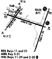
Runways
Runway Summary
| Runways: | 02/20 11/29 |
| Longest Runway: | 02/20 is 8000 ft (2438 m) long |
| Runways with an Instrument Approach: | 02, 20, 29 |
BMI Airport Runway Details
| Runway 02/20 | 8000 ft x 150 ft (2438 m x 46 m) | |
| Runway Length Source: | 3RD PARTY SURVEY as of 11/08/2007 | |
| Surface: | Concrete - Good condition - Saw-cut or plastic grooved | |
| Runway Pavement Class: | 45 /R/C/X/T | |
| Runway Edge Lights: | High Intensity | |
Runway Weight Bearing Capacity (in thousands of pounds) |
||
| Single Wheel Landing Gear: | 114.0 | |
| Dual Wheel Landing Gear: | 155.0 | |
| Dual Tandem Wheel Landing Gear: | 244.0 | |
Runway 02 |
Runway 20 |
|
Elevation: |
856.4 | 862.5 |
Latitude: |
40-27-50.5805N | 40-29-05.8019N |
Longitude: |
088-54-57.6912W | 088-54-25.8628W |
|
Runway True Alignment: |
018 | 198 |
ILS Type: |
ILS/DME | ILS/DME |
Glide Path Angle: |
3.0 degrees | 0.0 degrees |
Runway Markings Type: |
Precision Instrument | Precision Instrument |
Runway Markings Condition: |
Fair | Fair |
Object at End: |
PLINE | |
Object Height: |
40 | |
Distance from End: |
2007 | |
Object Centerline Offset: |
770 ft. left of centerline | |
Visual Glide Slope Indicators: |
4-Light PAPI On Right Side Of Runway | |
Runway Visual Range (RVR): |
Touchdown, Midfield, Rollout | Touchdown, Midfield, Rollout |
Approach Light System: |
1,400 Foot Medium Intensity Approach Lighting System With Runway Alignment Indicator Lights | Standard 2,400 Foot High Intensity Approach Lighting System With Sequenced Flashers, Cat. II or III Config. |
Touchdown Lights: |
Yes | |
Centerline Lights: |
Yes | Yes |
Threshold Crossing Height: |
75 | |
Declared Distances |
||
Take Off Run Avbl. (TORA): |
8000 | 8000 |
Take Off Distance Avbl. (TODA): |
8000 | 8000 |
Actual Stop Dist. Avbl. (ASDA): |
8000 | 8000 |
Landing Dist. Avbl. (LDA): |
8000 | 8000 |
| Runway 11/29 | 6525 ft x 150 ft (1989 m x 46 m) | |
| Runway Length Source: | 3RD PARTY SURVEY as of 11/08/2007 | |
| Surface: | Concrete - Good condition - Saw-cut or plastic grooved | |
| Runway Pavement Class: | 42 /F/C/X/T | |
| Runway Edge Lights: | High Intensity | |
Runway Weight Bearing Capacity (in thousands of pounds) |
||
| Single Wheel Landing Gear: | 109.0 | |
| Dual Wheel Landing Gear: | 151.0 | |
| Dual Tandem Wheel Landing Gear: | 249.0 | |
Runway 11 |
Runway 29 |
|
Elevation: |
871.4 | 871.1 |
Latitude: |
40-28-59.0521N | 40-28-39.2504N |
Longitude: |
088-55-56.4334W | 088-54-36.0841W |
|
Runway True Alignment: |
107 | 287 |
ILS Type: |
ILS/DME | |
Glide Path Angle: |
3.0 degrees | 0.0 degrees |
Traffic Pattern: |
Left | Left |
Runway Markings Type: |
Precision Instrument | Precision Instrument |
Runway Markings Condition: |
Good | Good |
Object Centerline Offset: |
770 ft. left of centerline | |
Visual Glide Slope Indicators: |
4-Box VASI On Right Side Of Runway | |
Runway Visual Range (RVR): |
Rollout | Touchdown |
Approach Light System: |
1,400 Foot Medium Intensity Approach Lighting System With Runway Alignment Indicator Lights | |
REIL: |
No | No |
Touchdown Lights: |
No | No |
Centerline Lights: |
No | No |
Threshold Crossing Height: |
43 | |
Declared Distances |
||
Take Off Run Avbl. (TORA): |
6525 | 6525 |
Take Off Distance Avbl. (TODA): |
6525 | 6525 |
Actual Stop Dist. Avbl. (ASDA): |
6525 | 6525 |
Landing Dist. Avbl. (LDA): |
6525 | 6525 |
Services
Airframe Repair: |
None |
Powerplant Repair: |
None |
Bottled Oxygen: |
None |
Bulk Oxygen: |
None |
Fuel Available: |
100LL, Jet A |
Landing Fees: |
No |
Parking: |
Hangars and tiedowns available |
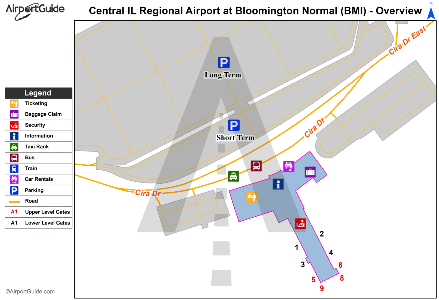
Maps & Diagrams
BMI Sectional
Flight Planning
at skyvector.com
at skyvector.com