Location
Latitude: |
41-36-29.1490N (41.608097) |
Longitude: |
088-05-47.0030W (-88.09639) |
Elevation: |
679.0 feet MSL (207 m MSL) |
Magnetic Variation: |
3.8 W (as of April 2024 from WMM2020 model) |
Time Zone: |
UTC -6.0 (Standard Time) UTC -5.0 (Daylight Savings Time) |
From City: |
20 N.M. SW of Chicago/Romeoville, Illinois |
Found On: |
Chicago Chart |
FAA Region: |
AGL |
Contacts
Manager: |
Publicly owned: |
| CHRIS LAWSON #1 EXECUTVE TERMINAL, GEORGE MICHAS DRIVE ROMEOVILLE, IL 60446-7175 815-838-9497 |
JOLIET REGIONAL PORT DIST #1 EXECUTIVE TERMINAL, GEORGE MICHAS DRIVE ROMEOVILLE, IL 60446-7175 815-838-9497 |
Operations
Airport Status: |
Operational |
Facility Use: |
Public |
Type: |
Airport |
Activation Date: |
04/1940 |
Control tower: |
Yes |
Attendance (Months/Days/Hours): |
Months/Days/Hours ALL/ALL/0700-2100 |
Boundary ARTCC: |
ZAU (Chicago) |
Responsible ARTCC: |
ZAU (Chicago) |
Lighting Schedule: |
SEE RMK |
Segmented Circle Indicator: |
No |
Traffic Pattern Altitude (MSL): |
1679 feet (512 m) |
NOTAMs Facility: |
LOT |
NOTAM-D Service: |
Yes |
International Airport of Entry: |
No |
Customs Landing Rights: |
No |
Military Landing Rights: |
No |
Civil/Military Joint Use: |
No |
Based Aircraft
| Single Engine: | 110 |
| Multi Engine: | 12 |
| Jet Engine: | 7 |
| GA Helicopters: | 4 |
Annual Operations (as of 07/31/2022)
| Total Operations: | 104000 | |
| Air Taxi: | 4000 | 3.8% |
| GA Local: | 60000 | 57.7% |
| GA Itinerant: | 40000 | 38.5% |
Communications
| CTAF: | 134.800 |
| Tower: | LEWIS 134.8 Hrs: 0600-2000 |
| Ground: | 120.425 |
| Approach: | CHICAGO 119.35 119.35 |
| Departure: | CHICAGO 119.35 119.35 |
| ATIS: | 126.675 Hrs: 24 |
| AWOS-3PT: | 126.675 (815-588-4802) |
Fixed Based Operators (FBOs) & Fuel
(Click on a business for detail)
Please help us keep this information up to date. This is a FREE SERVICE just like everything else on Airport Guide! If you see that a business needs to be added, modified, or deleted please fill out our Update Form.
To add, modify, or delete a business click here.
Please help us keep this information up to date. This is a FREE SERVICE just like everything else on Airport Guide! If you see that a business needs to be added, modified, or deleted please fill out our Update Form.
Area Code: 815 |
| Business Name | Frequency | Phone | Fuel Grade |
|---|---|---|---|
| Blatti Aviation
Update FBO info |
423-5659, 838-8359 | ||
| Chicago-Romeoville
Update FBO info |
Unicom 122.8 | 838-9497 | 80, 100LL, Jet A |
| J. F. Aviation, Inc.
Update FBO info |
Unicom 122.75 | 838-4848 | |
| Lewis University Aviation Services
Update FBO info |
Unicom 122.8 | 834-4206 |
Flight Service Stations
| Primary | Alternate | |
| FSS on Field: | N | |
| FSS Name (ID): | Kankakee(IKK) | |
| Frequency: | ||
| Toll Free Phone: | 1-800-WX-BRIEF |
Instrument Procedures / Charts
FAA Terminal Procedures valid from 0901Z 03/21/24 to 0901Z 04/18/24.
There are various types of charts available for an airport. They are listed in the Page Type column. Here is a legend for those types:
APD - Airport Diagram
DP - Departure Procedure Charts
HOT - Hot Spots
IAP - Instrument Approach Procedure Charts
MIN - Minimums
STAR - Standard Terminal Arrival Charts
| Page Type | Page Name | Volume | Action Since Last Cycle |
|---|---|---|---|
| APD | AIRPORT DIAGRAM | EC-3 | Changed |
| DP | ADELL SIX (RNAV) | EC-3 | |
| DP | BLOKR SIX (RNAV) | EC-3 | |
| DP | CARYN SIX (RNAV) | EC-3 | |
| DP | DARCY SIX (RNAV) | EC-3 | |
| DP | ELANR SIX (RNAV) | EC-3 | |
| DP | OBENE THREE (RNAV) | EC-3 | |
| DP | OBENE THREE (RNAV)[DELIMITER] CONT.1 | EC-3 | |
| IAP | LOC RWY 02 | EC-3 | |
| IAP | LOC/DME RWY 09 | EC-3 | |
| IAP | RNAV (GPS) RWY 02 | EC-3 | |
| IAP | RNAV (GPS) RWY 09 | EC-3 | |
| IAP | RNAV (GPS) RWY 20 | EC-3 | |
| IAP | RNAV (GPS) RWY 27 | EC-3 | |
| MIN | ALTERNATE MINIMUMS | EC-3 | |
| MIN | TAKEOFF MINIMUMS | EC-3 |
Terminal Procedures are only available for airports in several countries with more being added all the time. If you are looking for a specific country's charts, please send an email to support(at)airportguide.com stating the country name. This will be used to prioritize the implementation.
Navigation Aids (Navaids) near LOT
| Dist (NM) | ID | Morse Code | Name | Type | Freq | True Hdg | Mag Hdg |
|---|---|---|---|---|---|---|---|
| 10.6 | JOT | . _ _ _ _ _ _ _ | Joliet | VOR-DME | 112.30 | 249 | 253 |
| 13.4 | HK | . . . . _ . _ | Ermin | NDB | 332 | 60 | 64 |
| 18.8 | MDW | _ _ _ . . . _ _ | Chicago Midway | VOT | 111.00 | 55 | 59 |
| 19.9 | MX | _ _ _ . . _ | Kedzi | NDB | 248 | 66 | 70 |
| 20.4 | DPA | _ . . . _ _ . . _ | Dupage | VOR-DME | 108.40 | 326 | 330 |
| 21.8 | ME | _ _ . | Deana | NDB | 350 | 8 | 12 |
| 24.3 | CGT | _ . _ . _ _ . _ | Chicago Heights | VORTAC | 114.20 | 103 | 107 |
| 24.3 | ORD | _ _ _ . _ . _ . . | Chicago O'hare | VOR-DME | 113.90 | 20 | 24 |
| 24.5 | EON | . _ _ _ _ . | Peotone | VORTAC | 113.20 | 145 | 149 |
| 24.7 | GCO | _ _ . _ . _ . _ _ _ | Chicago | DME | 108.25 | 20 | 24 |
| 33.9 | IKK | . . _ . _ _ . _ | Kankakee | DME | 111.6 | 160 | 164 |
| 36.5 | IK | . . _ . _ | Lukow | NDB | 272 | 166 | 170 |
| 37.1 | OIX | _ _ _ . . _ . . _ | Ottawa | NDB | 266 | 246 | 250 |
| 37.4 | OBK | _ _ _ _ . . . _ . _ | Northbrook | VOR-DME | 113.00 | 9 | 13 |
| 53.0 | UG | . . _ _ _ . | Wauke | NDB | 379 | 14 | 18 |
| 54.1 | RF | . _ . . . _ . | Gilmy | NDB | 275 | 304 | 307 |
| 55.3 | PNT | . _ _ . _ . _ | Pontiac | VOR-DME | 109.60 | 211 | 215 |
| 55.6 | VP | . . . _ . _ _ . | Sedly | NDB | 212 | 99 | 103 |
| 57.2 | EN | . _ . | Codee | NDB | 389 | 2 | 6 |
| 59.9 | IUL | . . . . _ . _ . . | La Porte | NDB | 356 | 95 | 99 |
Nearby Airports with Fuel
Notices to Airmen (NOTAMS)
Remarks
| A110-2 | N PARKING RAMP CLSD TO ALL MULTI ENGINE ACFT. |
| A110-4 | BIRDS ON & INVOF ARPT. |
| A110-5 | CHICAGO APPROACH CLEARANCE 847-289-0926 |
| A110-6 | FOR CD CTC CHICAGO APCH AT 847-289-0926. |
| A110-7 | TWYS N1 AND N2 CLSD TO FIXED WING ACFT MORE THAN 6000LB. |
| A110-8 | BA CONDS ARE NOT RPRTD BTN 2100 - 0600. |
| A15 | EAMIL ADDRESS: CLAWSON@FLYLOT.COM (ALL LOWER CASE) |
| A16 | AMGR ADDNL PHONE NUMBER - 815-838-9512. EMAIL: CLAWSON@FLYLOT.COM |
| A81-APT | MIRL RY 02/20 & 09/27 PRESET ON LOW INTST; TO INCR INTST ACTVT - CTAF. ACTVT REIL RYS 02/20 & 09/27 & PAPI RYS 02/ 20 & 09/27 - CTAF. |
Runways
Runway Summary
| Runways: | 02/20 09/27 |
| Longest Runway: | 02/20 is 6500 ft (1981 m) long |
| Runways with an Instrument Approach: | 02, 09 |
LOT Airport Runway Details
| Runway 02/20 | 6500 ft x 100 ft (1981 m x 30 m) | |
| Runway Length Source: | 3RD PARTY SURVEY as of 12/07/2018 | |
| Surface: | Concrete - Good condition - Saw-cut or plastic grooved | |
| Runway Edge Lights: | Medium Intensity | |
Runway Weight Bearing Capacity (in thousands of pounds) |
||
| Dual Wheel Landing Gear: | 99.0 | |
Runway 02 |
Runway 20 |
|
Elevation: |
679.0 | 665.9 |
Latitude: |
41-35-57.2324N | 41-36-59.6150N |
Longitude: |
088-06-03.2289W | 088-05-42.9198W |
|
Runway True Alignment: |
013 | 193 |
ILS Type: |
LOC/DME | |
Glide Path Angle: |
3.0 degrees | 3.2 degrees |
Runway Markings Type: |
Nonprecision Instrument | Nonprecision Instrument |
Runway Markings Condition: |
Good | Good |
Object at End: |
ANT | |
Object Height: |
190 | |
Distance from End: |
4999 | |
Object Centerline Offset: |
366 ft. right of centerline | |
Visual Glide Slope Indicators: |
4-Light PAPI On Left Side Of Runway | 4-Light PAPI On Left Side Of Runway |
REIL: |
Yes | Yes |
Threshold Crossing Height: |
37 | 40 |
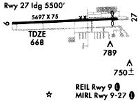
| Runway 09/27 | 5500 ft x 75 ft (1676 m x 23 m) | |
| Runway Length Source: | 3RD PARTY SURVEY as of 12/07/2018 | |
| Surface: | Concrete - Good condition - Porous friction course | |
| Runway Edge Lights: | Medium Intensity | |
Runway Weight Bearing Capacity (in thousands of pounds) |
||
| Single Wheel Landing Gear: | 20.0 | |
| Dual Wheel Landing Gear: | 75.0 | |
Runway 09 |
Runway 27 |
|
Elevation: |
673.1 | 665.8 |
Latitude: |
41-36-28.9292N | 41-36-31.0811N |
Longitude: |
088-06-15.9971W | 088-05-03.6538W |
|
Runway True Alignment: |
088 | 268 |
ILS Type: |
LOC/DME | |
Glide Path Angle: |
3.0 degrees | 3.0 degrees |
Traffic Pattern: |
Left | Left |
Runway Markings Type: |
Nonprecision Instrument | Nonprecision Instrument |
Runway Markings Condition: |
Good | Good |
Object Centerline Offset: |
366 ft. right of centerline | |
Visual Glide Slope Indicators: |
4-Light PAPI On Left Side Of Runway | 4-Light PAPI On Left Side Of Runway |
REIL: |
Yes | Yes |
Touchdown Lights: |
No | No |
Centerline Lights: |
No | No |
Threshold Crossing Height: |
41 | 35 |
Services
Airframe Repair: |
None |
Powerplant Repair: |
None |
Bottled Oxygen: |
None |
Bulk Oxygen: |
None |
Fuel Available: |
100LL, Jet A |
Landing Fees: |
No |
Parking: |
Hangars and tiedowns available |
Maps & Diagrams
LOT Sectional
Flight Planning
at skyvector.com
at skyvector.com