Location
Latitude: |
40-26-56.3240N (40.448979) |
Longitude: |
088-07-39.8570W (-88.127738) |
Elevation: |
779.0 feet MSL (237 m MSL) |
Magnetic Variation: |
3.6 W (as of April 2024 from WMM2020 model) |
Time Zone: |
UTC -6.0 (Standard Time) UTC -5.0 (Daylight Savings Time) |
From City: |
02 N.M. SW of Paxton, Illinois |
Found On: |
Chicago Chart |
FAA Region: |
AGL |
Contacts
Manager: |
Privately owned: |
| DAVID HRUPSA 4960 FORT DENAUD RD FORT DEANUD, FL 33935 252-945-4804 |
DAVID HRUPSA 4960 FORT DENAUD RD FORT DENAUD, FL 33935 252-945-4804 |
Operations
Airport Status: |
Operational |
Facility Use: |
Public |
Type: |
Airport |
Activation Date: |
11/1968 |
Control tower: |
No |
Attendance (Months/Days/Hours): |
Months/Days/Hours ALL/ALL/IREG |
Boundary ARTCC: |
ZAU (Chicago) |
Responsible ARTCC: |
ZAU (Chicago) |
Lighting Schedule: |
SS-SR |
Segmented Circle Indicator: |
No |
Traffic Pattern Altitude (MSL): |
1779 feet (542 m) |
NOTAMs Facility: |
STL |
NOTAM-D Service: |
Yes |
Based Aircraft
| Single Engine: | 11 |
| Ultralights: | 6 |
Annual Operations (as of 07/31/2022)
| Total Operations: | 4000 | |
| Air Taxi: | 200 | 5.0% |
| GA Local: | 1800 | 45.0% |
| GA Itinerant: | 2000 | 50.0% |
Communications
| CTAF: | 122.800 |
| Unicom: | 122.800 |
| Approach: | CHAMPAIGN 121.35 121.35 CHICAGO ARTCC |
| Departure: | CHAMPAIGN 121.35 121.35 CHICAGO ARTCC |
- APCH/DEP SVC PRVDD BY CHICAGO ARTCC ON REMOTED CHAMPAIGN APCH CTL FREQS 121.35 & 353.95 (DANVILLE RCAG) WHEN CHAMPAIGN APCH CTL CLSD.
Fixed Based Operators (FBOs) & Fuel
(Click on a business for detail)
Please help us keep this information up to date. This is a FREE SERVICE just like everything else on Airport Guide! If you see that a business needs to be added, modified, or deleted please fill out our Update Form.
To add, modify, or delete a business click here.
Please help us keep this information up to date. This is a FREE SERVICE just like everything else on Airport Guide! If you see that a business needs to be added, modified, or deleted please fill out our Update Form.
Area Code: 217 |
| Business Name | Frequency | Phone | Fuel Grade |
|---|---|---|---|
| Specchio Aviation
Update FBO info |
379-4396 | 100LL, Mogas |
Flight Service Stations
| Primary | Alternate | |
| FSS on Field: | N | |
| FSS Name (ID): | Saint Louis(STL) | |
| Frequency: | ||
| Toll Free Phone: | 1-800-WX-BRIEF |
Instrument Procedures / Charts
FAA Terminal Procedures valid from 0901Z 03/21/24 to 0901Z 04/18/24.
There are various types of charts available for an airport. They are listed in the Page Type column. Here is a legend for those types:
APD - Airport Diagram
DP - Departure Procedure Charts
HOT - Hot Spots
IAP - Instrument Approach Procedure Charts
MIN - Minimums
STAR - Standard Terminal Arrival Charts
| Page Type | Page Name | Volume | Action Since Last Cycle |
|---|---|---|---|
| IAP | RNAV (GPS) RWY 18 | EC-3 | |
| IAP | VOR RWY 18 | EC-3 | |
| MIN | TAKEOFF MINIMUMS | EC-3 |
Terminal Procedures are only available for airports in several countries with more being added all the time. If you are looking for a specific country's charts, please send an email to support(at)airportguide.com stating the country name. This will be used to prioritize the implementation.
Navigation Aids (Navaids) near 1C1
| Dist (NM) | ID | Morse Code | Name | Type | Freq | True Hdg | Mag Hdg |
|---|---|---|---|---|---|---|---|
| 8.1 | RBS | . _ . _ . . . . . . | Roberts | VOR-DME | 116.80 | 348 | 352 |
| 25.8 | CMI | _ . _ . _ _ . . | Champaign | VORTAC | 110.00 | 195 | 199 |
| 26.6 | HMJ | . . . . _ _ . _ _ _ | Homer | NDB | 281 | 162 | 166 |
| 27.7 | DNV | _ . . _ . . . . _ | Danville | VORTAC | 111.00 | 109 | 113 |
| 29.0 | DN | _ . . _ . | Julip | NDB | 332 | 109 | 113 |
| 29.1 | CM | _ . _ . _ _ | Veals | NDB | 407 | 184 | 188 |
| 34.7 | LH | . _ . . . . . . | Egrow | NDB | 334 | 281 | 284 |
| 35.5 | PNT | . _ _ . _ . _ | Pontiac | VOR-DME | 109.60 | 309 | 312 |
| 35.6 | IK | . . _ . _ | Lukow | NDB | 272 | 16 | 20 |
| 36.7 | BMI | _ . . . _ _ . . | Bloomington | DME | 108.2 | 273 | 276 |
| 39.6 | IKK | . . _ . _ _ . _ | Kankakee | DME | 111.6 | 18 | 22 |
| 45.1 | DEC | _ . . . _ . _ . | Akley | FAN MARKER | 220 | 223 | |
| 48.7 | BVT | _ . . . . . . _ _ | Boiler | VORTAC | 115.10 | 82 | 86 |
| 49.1 | LA | . _ . . . _ | Earle | NDB | 401 | 91 | 95 |
| 51.6 | EON | . _ _ _ _ . | Peotone | VORTAC | 113.20 | 17 | 21 |
| 54.2 | AXC | . _ _ . . _ _ . _ . | Adders | VORTAC | 117.20 | 218 | 221 |
| 54.8 | DE | _ . . . | Elwin | NDB | 275 | 224 | 227 |
| 58.0 | AAA | . _ . _ . _ | Abraham | NDB | 329 | 253 | 256 |
| 58.7 | MTO | _ _ _ _ _ _ | Mattoon | DME | 109.4 | 187 | 191 |
| 60.4 | MT | _ _ _ | Zebre | NDB | 347 | 182 | 186 |
Nearby Airports with Fuel
Notices to Airmen (NOTAMS)
Remarks
| A110*G | THIS AIRPORT HAS BEEN SURVEYED BY THE NATIONAL GEODETIC SURVEY. |
| A110-1 | AFT HR ACES TO AP TERM VIA CIPHER LOCK HINT TO COMBO POSTED. |
| A110-2 | FOR CD CTC CHAMPAIGN APCH AT 217-355-4071, WHEN APCH CLSD CTC CHICAGO ARTCC AT 630-906-8921 |
| A40-18/36 | NSTD LIRL - FIXTURE SPACING & LGT INTSTY VARIES. |
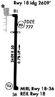
| A51-18 | DTHR PAINTED WHITE LINE ACROSS RY. |
| A57-18 | RWY 18 APCH RATIO 22:1 TO DTHR. |
| A58-18 | 25 FT BLDG 175 FT FM RWY END AND 150 FT R. |
| E111 | ALL OPNS TO BE CONDD ON E SIDE OF N/S RWY. |
Runways
Runway Summary
| Runways: | 18/36 |
| Longest Runway: | 18/36 is 3409 ft (1039 m) long |
| Runways with an Instrument Approach: |
1C1 Airport Runway Details
| Runway 18/36 | 3409 ft x 50 ft (1039 m x 15 m) | |
| Surface: | Asphalt - Fair condition - No special surface treatment | |
| Runway Edge Lights: | Non-standard lighting system Intensity | |
Runway Weight Bearing Capacity (in thousands of pounds) |
||
| Single Wheel Landing Gear: | 12.5 | |
Runway 18 |
Runway 36 |
|
Elevation: |
779.0 | 755.0 |
Latitude: |
40-27-13.1610N | 40-26-39.4790N |
Longitude: |
088-07-39.9370W | 088-07-39.7990W |
|
Runway True Alignment: |
180 | 360 |
Glide Path Angle: |
0.0 degrees | 3.0 degrees |
Traffic Pattern: |
Left | |
Runway Markings Type: |
Nonprecision Instrument | Numbers Only |
Runway Markings Condition: |
Good | Good |
Object at End: |
TREE | |
Object Height: |
56 | |
Distance from End: |
601 | |
Object Centerline Offset: |
58 ft. left of centerline | |
Visual Glide Slope Indicators: |
Tri-color VASI On Left Side Of Runway | |
REIL: |
Yes | |
Threshold Crossing Height: |
50 | |
Threshold Elevation: |
777.4 | |
Displaced Threshold: |
800 | |
Threshold Latitude: |
40-27-05.2500N | |
Threshold Longitude: |
088-07-39.9100W |
Services
Airframe Repair: |
Major |
Powerplant Repair: |
Major |
Fuel Available: |
100LL |
Landing Fees: |
No |
Parking: |
Hangars and tiedowns available |
Maps & Diagrams
1C1 Sectional
Flight Planning
at skyvector.com
at skyvector.com