Location
Latitude: |
41-32-05.7000N (41.534917) |
Longitude: |
087-31-46.3000W (-87.529528) |
Elevation: |
619.7 feet MSL (189 m MSL) |
Magnetic Variation: |
4.2 W (as of April 2024 from WMM2020 model) |
Time Zone: |
UTC -6.0 (Standard Time) UTC -5.0 (Daylight Savings Time) |
From City: |
21 N.M. S of Chicago, Illinois |
Found On: |
Chicago Chart |
FAA Region: |
AGL |
Contacts
Manager: |
Publicly owned: |
| BRIAN HANIGAN 3250 BOB MALKAS DR LANSING, IL 60438 (708) 418-5888 |
VILLAGE OF LANSING 3141 RIDGE RD LANSING, IL 60438-3021 (708) 895-7200 |
Operations
Airport Status: |
Operational |
Facility Use: |
Public |
Type: |
Airport |
Activation Date: |
04/1940 |
Control tower: |
No |
Attendance (Months/Days/Hours): |
Months/Days/Hours ALL/ALL/0700-1500 |
Boundary ARTCC: |
ZAU (Chicago) |
Responsible ARTCC: |
ZAU (Chicago) |
Lighting Schedule: |
SEE RMK |
Segmented Circle Indicator: |
No |
Traffic Pattern Altitude (MSL): |
1620 feet (494 m) |
NOTAMs Facility: |
IGQ |
NOTAM-D Service: |
Yes |
International Airport of Entry: |
No |
Customs Landing Rights: |
No |
Military Landing Rights: |
Yes |
Civil/Military Joint Use: |
No |
Based Aircraft
| Single Engine: | 80 |
| Multi Engine: | 8 |
| GA Helicopters: | 5 |
| Gliders: | 1 |
| Ultralights: | 1 |
Annual Operations (as of 06/30/2023)
| Total Operations: | 59400 | |
| Air Taxi: | 5500 | 9.3% |
| GA Local: | 29700 | 50.0% |
| GA Itinerant: | 24200 | 40.7% |
Communications
| CTAF: | 122.700 |
| Unicom: | 122.700 |
| Approach: | CHICAGO 128.2 128.2 128.2 128.2 128.2 128.2 |
| Departure: | CHICAGO 128.2 128.2 128.2 128.2 128.2 128.2 |
| AWOS-3PT: | 119.275 (708-889-6319) |
Fixed Based Operators (FBOs) & Fuel
(Click on a business for detail)
Please help us keep this information up to date. This is a FREE SERVICE just like everything else on Airport Guide! If you see that a business needs to be added, modified, or deleted please fill out our Update Form.
To add, modify, or delete a business click here.
Please help us keep this information up to date. This is a FREE SERVICE just like everything else on Airport Guide! If you see that a business needs to be added, modified, or deleted please fill out our Update Form.
Area Code: 708 |
| Business Name | Frequency | Phone | Fuel Grade |
|---|---|---|---|
| Associated Air Activities
Update FBO info |
Unicom 122.7, Arinc 123.3 | 474-6073 | 80, 100LL, Jet A |
| Chicago Business Air Center
Update FBO info |
Unicom 123.5 | 800-845-5826, 895-2666, 895-2695 | 100LL, Jet A |
| Sun Aero Helicopters, Inc.
Website Update FBO info |
Unicom 122.7 | 895-8958 |
Flight Service Stations
| Primary | Alternate | |
| FSS on Field: | N | |
| FSS Name (ID): | Kankakee(IKK) | |
| Frequency: | ||
| Toll Free Phone: | 1-800-WX-BRIEF |
Instrument Procedures / Charts
FAA Terminal Procedures valid from 0901Z 03/21/24 to 0901Z 04/18/24.
There are various types of charts available for an airport. They are listed in the Page Type column. Here is a legend for those types:
APD - Airport Diagram
DP - Departure Procedure Charts
HOT - Hot Spots
IAP - Instrument Approach Procedure Charts
MIN - Minimums
STAR - Standard Terminal Arrival Charts
| Page Type | Page Name | Volume | Action Since Last Cycle |
|---|---|---|---|
| APD | AIRPORT DIAGRAM | EC-3 | |
| IAP | LOC RWY 36 | EC-3 | |
| IAP | RNAV (GPS) RWY 09 | EC-3 | |
| IAP | RNAV (GPS) RWY 27 | EC-3 | |
| IAP | RNAV (GPS) RWY 36 | EC-3 | |
| IAP | VOR-A | EC-3 | |
| MIN | ALTERNATE MINIMUMS | EC-3 | |
| MIN | TAKEOFF MINIMUMS | EC-3 | |
| STAR | GOSHEN NINE | EC-3 | |
| STAR | LUCIT TWO (RNAV) | EC-3 | |
| STAR | LUCIT TWO (RNAV)[DELIMITER] CONT.1 | EC-3 |
Terminal Procedures are only available for airports in several countries with more being added all the time. If you are looking for a specific country's charts, please send an email to support(at)airportguide.com stating the country name. This will be used to prioritize the implementation.
Navigation Aids (Navaids) near KIGQ
| Dist (NM) | ID | Morse Code | Name | Type | Freq | True Hdg | Mag Hdg |
|---|---|---|---|---|---|---|---|
| 2.4 | CGT | _ . _ . _ _ . _ | Chicago Heights | VORTAC | 114.20 | 231 | 235 |
| 14.3 | MX | _ _ _ . . _ | Kedzi | NDB | 248 | 329 | 333 |
| 17.6 | HK | . . . . _ . _ | Ermin | NDB | 332 | 308 | 312 |
| 18.1 | MDW | _ _ _ . . . _ _ | Chicago Midway | VOT | 111.00 | 326 | 330 |
| 19.8 | EON | . _ _ _ _ . | Peotone | VORTAC | 113.20 | 216 | 220 |
| 29.7 | VP | . . . _ . _ _ . | Sedly | NDB | 212 | 99 | 103 |
| 31.2 | IKK | . . _ . _ _ . _ | Kankakee | DME | 111.6 | 207 | 211 |
| 31.9 | ORD | _ _ _ . _ . _ . . | Chicago O'hare | VOR-DME | 113.90 | 328 | 332 |
| 32.2 | GCO | _ _ . _ . _ . _ _ _ | Chicago | DME | 108.25 | 328 | 332 |
| 34.1 | IUL | . . . . _ . _ . . | La Porte | NDB | 356 | 93 | 97 |
| 34.2 | ME | _ _ . | Deana | NDB | 350 | 319 | 323 |
| 35.3 | IK | . . _ . _ | Lukow | NDB | 272 | 208 | 212 |
| 35.4 | JOT | . _ _ _ _ _ _ _ | Joliet | VOR-DME | 112.30 | 271 | 275 |
| 41.6 | OXI | _ _ _ _ . . _ . . | Knox | DME | 115.6 | 107 | 112 |
| 42.5 | DPA | _ . . . _ _ . . _ | Dupage | VOR-DME | 108.40 | 300 | 304 |
| 45.3 | OBK | _ _ _ _ . . . _ . _ | Northbrook | VOR-DME | 113.00 | 335 | 339 |
| 49.4 | RWN | . _ . . _ _ _ . | Winamac/Dcmsnd | NDB | 335 | 122 | 127 |
| 55.0 | CPB | _ . _ . . _ _ . _ . . . | Culver | NDB | 391 | 109 | 114 |
| 56.1 | GIJ | _ _ . . . . _ _ _ | Gipper | VORTAC | 115.40 | 75 | 80 |
| 57.0 | UG | . . _ _ _ . | Wauke | NDB | 379 | 347 | 351 |
Nearby Airports with Fuel
Notices to Airmen (NOTAMS)
Remarks
| A110-4 | ALL PATTERN FLYING IN NOISE SENSITIVE AREA. |
| A110-5 | BIRDS & WILDLIFE ON & INVOF ARPT. |
| A110-7 | 146 FT TOWER 4325 FT FROM RY 27 665 FT RIGHT OF EXTENDED CNTRLN. |
| A110-8 | FOR CD CTC CHICAGO APCH AT 847-289-0926. |
| A15 | EMAIL ADDRESS: PPATLAK@VILLAGEOFLANSING.ORG (ALL LOWER CASE) |
| A16 | (708) 895-7200 |
| A70-FUEL-10 | 0LL SELF SERVE FUEL AVBL H24 WITH CREDIT CARD. |
| A81-APT | ACTVT REIL RWY 09, 18, 27 & 36; MIRL RWY 09/27 & 18/36; TWY LGTS - CTAF. MIRL RWY 18/36 PRESET TO LOW INTST; INCR INTST - CTAF. |
| E111 | EXISTED PRIOR TO 1959. |
Runways
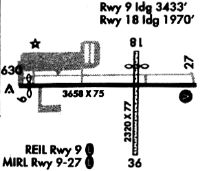
Runway Summary
| Runways: | 09/27 18/36 |
| Longest Runway: | 18/36 is 4002 ft (1220 m) long |
| Runways with an Instrument Approach: | 36 |
KIGQ Airport Runway Details
| Runway 09/27 | 3395 ft x 75 ft (1035 m x 23 m) | |
| Runway Length Source: | 3RD PARTY SURVEY as of 09/12/2005 | |
| Surface: | Asphalt/Treated - Good condition - Porous friction course | |
| Runway Edge Lights: | Medium Intensity | |
Runway Weight Bearing Capacity (in thousands of pounds) |
||
| Single Wheel Landing Gear: | 12.5 | |
Runway 09 |
Runway 27 |
|
Elevation: |
614.5 | 616.6 |
Latitude: |
41-32-23.6300N | 41-32-23.5300N |
Longitude: |
087-32-16.4400W | 087-31-31.7900W |
|
Runway True Alignment: |
090 | 270 |
Glide Path Angle: |
3.0 degrees | 3.0 degrees |
Traffic Pattern: |
Left | Left |
Runway Markings Type: |
Nonprecision Instrument | Nonprecision Instrument |
Runway Markings Condition: |
Fair | Fair |
Object at End: |
BLDG | |
Object Height: |
26 | |
Distance from End: |
546 | |
Object Centerline Offset: |
95 ft. left of centerline | |
Visual Glide Slope Indicators: |
2-Light PAPI On Left Side Of Runway | 2-Light PAPI On Left Side Of Runway |
REIL: |
Yes | Yes |
Threshold Crossing Height: |
40 | 40 |
| Runway 18/36 | 4002 ft x 75 ft (1220 m x 23 m) | |
| Runway Length Source: | 3RD PARTY SURVEY as of 09/12/2005 | |
| Surface: | Asphalt/Treated - Good condition - Porous friction course | |
| Runway Edge Lights: | Medium Intensity | |
Runway Weight Bearing Capacity (in thousands of pounds) |
||
| Single Wheel Landing Gear: | 24.0 | |
Runway 18 |
Runway 36 |
|
Elevation: |
616.6 | 618.5 |
Latitude: |
41-32-10.2500N | 41-31-30.7100N |
Longitude: |
087-31-39.5900W | 087-31-39.7200W |
|
Runway True Alignment: |
180 | 000 |
ILS Type: |
LOC/DME | |
Glide Path Angle: |
3.0 degrees | 3.0 degrees |
Runway Markings Type: |
Nonprecision Instrument | Nonprecision Instrument |
Runway Markings Condition: |
Fair | Fair |
Object Centerline Offset: |
95 ft. left of centerline | |
Visual Glide Slope Indicators: |
2-Light PAPI On Left Side Of Runway | 2-Light PAPI On Left Side Of Runway |
REIL: |
Yes | Yes |
Threshold Crossing Height: |
40 | 40 |
Services
Airframe Repair: |
Major |
Powerplant Repair: |
Major |
Bottled Oxygen: |
None |
Bulk Oxygen: |
None |
Fuel Available: |
100LL, Jet A, Jet A+ |
Landing Fees: |
No |
Parking: |
Hangars and tiedowns available |
Maps & Diagrams
KIGQ Sectional
Flight Planning
at skyvector.com
at skyvector.com