Location
Latitude: |
41-54-25.3910N (41.907053) |
Longitude: |
088-14-52.7820W (-88.247995) |
Elevation: |
758.5 feet MSL (231 m MSL) |
Magnetic Variation: |
3.7 W (as of April 2024 from WMM2020 model) |
Time Zone: |
UTC -6.0 (Standard Time) UTC -5.0 (Daylight Savings Time) |
From City: |
29 N.M. W of Chicago/West Chicago, Illinois |
Found On: |
Chicago Chart |
FAA Region: |
AGL |
Contacts
Manager: |
Publicly owned: |
| MARK DOLES 2700 INT'L DRIVE, STE 200 WEST CHICAGO, IL 60185-0787 630-584-2211 |
DUPAGE ARPT AUTH 2700 INTERNATIONAL DRIVE STE 200 WEST CHICAGO, IL 60185-0787 630-584-2211 |
Operations
Airport Status: |
Operational |
Facility Use: |
Public |
Type: |
Airport |
Activation Date: |
03/1943 |
Control tower: |
Yes |
Attendance (Months/Days/Hours): |
Months/Days/Hours ALL/ALL/ALL |
Boundary ARTCC: |
ZAU (Chicago) |
Responsible ARTCC: |
ZAU (Chicago) |
Lighting Schedule: |
SEE RMK |
Segmented Circle Indicator: |
No |
Traffic Pattern Altitude (MSL): |
1758 feet (536 m) |
NOTAMs Facility: |
DPA |
NOTAM-D Service: |
Yes |
International Airport of Entry: |
No |
Customs Landing Rights: |
No |
Military Landing Rights: |
Yes |
Civil/Military Joint Use: |
No |
Based Aircraft
| Single Engine: | 164 |
| Multi Engine: | 23 |
| Jet Engine: | 45 |
| GA Helicopters: | 4 |
Annual Operations (as of 05/31/2022)
| Total Operations: | 135932 | |
| Commercial: | 45 | 0.0% |
| Air Taxi: | 8745 | 6.4% |
| GA Local: | 67243 | 49.5% |
| GA Itinerant: | 59659 | 43.9% |
| Military Aircraft: | 240 | 0.2% |
Communications
| Unicom: | 122.950 |
| Tower: | DUPAGE 120.9 257.8 124.5 Hrs: 24 |
| Clearance Del.: | 119.75 |
| Ground: | 121.8 |
| Approach: | CHICAGO 133.5 133.5 |
| Departure: | CHICAGO 133.5 133.5 |
| ATIS: | 132.075 Hrs: 24 |
| ASOS: | (630-587-3668) |
Fixed Based Operators (FBOs) & Fuel
(Click on a business for detail)
Please help us keep this information up to date. This is a FREE SERVICE just like everything else on Airport Guide! If you see that a business needs to be added, modified, or deleted please fill out our Update Form.
To add, modify, or delete a business click here.
Please help us keep this information up to date. This is a FREE SERVICE just like everything else on Airport Guide! If you see that a business needs to be added, modified, or deleted please fill out our Update Form.
Area Code: 630 |
| Business Name | Frequency | Phone | Fuel Grade |
|---|---|---|---|
| American Flyers
Website Update FBO info |
584-4700, 800-323-0808 | ||
| Cameron Aircraft Interiors, Inc.
Update FBO info |
630-584-9359 | ||
| Cougar Aviation, Inc.
Website Update FBO info |
420-8744 | ||
| DuPage Flight Center
Update FBO info |
Unicom 122.95 | 800-208-5690, 208-5600 | 100LL, Jet A |
| J. A. Air Center
Website Update FBO info |
Unicom 122.95 | 800-323-5966, 584-3200 | |
| Mukenschnabl, Inc.
Update FBO info |
584-7570 | ||
| PilotMakers, Inc.
Update FBO info |
443-5130 | ||
| Safety, Ltd.
Update FBO info |
800-866-4886, 584-9366 | ||
| Scott Aviation
Website Update FBO info |
Unicom 122.95 | 513-2222 | |
| The Pilot Shop
Update FBO info |
377-6727 | ||
| Travel Express Aviation LLC
Website Update FBO info |
584-6462 |
Flight Service Stations
| Primary | Alternate | |
| FSS on Field: | N | |
| FSS Name (ID): | Kankakee(IKK) | |
| Frequency: | ||
| Toll Free Phone: | 1-800-WX-BRIEF |
Instrument Procedures / Charts
FAA Terminal Procedures valid from 0901Z 03/21/24 to 0901Z 04/18/24.
There are various types of charts available for an airport. They are listed in the Page Type column. Here is a legend for those types:
APD - Airport Diagram
DP - Departure Procedure Charts
HOT - Hot Spots
IAP - Instrument Approach Procedure Charts
MIN - Minimums
STAR - Standard Terminal Arrival Charts
| Page Type | Page Name | Volume | Action Since Last Cycle |
|---|---|---|---|
| APD | AIRPORT DIAGRAM | EC-3 | |
| DP | ADELL SIX (RNAV) | EC-3 | |
| DP | BLOKR SIX (RNAV) | EC-3 | |
| DP | CARYN SIX (RNAV) | EC-3 | |
| DP | DARCY SIX (RNAV) | EC-3 | |
| DP | ELANR SIX (RNAV) | EC-3 | |
| DP | OBENE THREE (RNAV) | EC-3 | |
| DP | OBENE THREE (RNAV)[DELIMITER] CONT.1 | EC-3 | |
| IAP | ILS OR LOC RWY 02L | EC-3 | |
| IAP | ILS OR LOC RWY 10 | EC-3 | |
| IAP | RNAV (GPS) RWY 02L | EC-3 | |
| IAP | RNAV (GPS) RWY 02R | EC-3 | |
| IAP | RNAV (GPS) RWY 10 | EC-3 | |
| IAP | RNAV (GPS) RWY 20L | EC-3 | |
| IAP | RNAV (GPS) RWY 20R | EC-3 | |
| MIN | ALTERNATE MINIMUMS | EC-3 | |
| MIN | TAKEOFF MINIMUMS | EC-3 |
Terminal Procedures are only available for airports in several countries with more being added all the time. If you are looking for a specific country's charts, please send an email to support(at)airportguide.com stating the country name. This will be used to prioritize the implementation.
Navigation Aids (Navaids) near DPA
| Dist (NM) | ID | Morse Code | Name | Type | Freq | True Hdg | Mag Hdg |
|---|---|---|---|---|---|---|---|
| 4.7 | DPA | _ . . . _ _ . . _ | Dupage | VOR-DME | 108.40 | 257 | 261 |
| 10.5 | ME | _ _ . | Deana | NDB | 350 | 69 | 73 |
| 16.1 | ORD | _ _ _ . _ . _ . . | Chicago O'hare | VOR-DME | 113.90 | 72 | 76 |
| 16.3 | GCO | _ _ . _ . _ . _ _ _ | Chicago | DME | 108.25 | 71 | 75 |
| 21.6 | HK | . . . . _ . _ | Ermin | NDB | 332 | 121 | 125 |
| 21.9 | JOT | . _ _ _ _ _ _ _ | Joliet | VOR-DME | 112.30 | 188 | 192 |
| 23.0 | OBK | _ _ _ _ . . . _ . _ | Northbrook | VOR-DME | 113.00 | 34 | 38 |
| 23.3 | MDW | _ _ _ . . . _ _ | Chicago Midway | VOT | 111.00 | 107 | 111 |
| 26.9 | MX | _ _ _ . . _ | Kedzi | NDB | 248 | 111 | 115 |
| 38.5 | CGT | _ . _ . _ _ . _ | Chicago Heights | VORTAC | 114.20 | 127 | 131 |
| 38.9 | UG | . . _ _ _ . | Wauke | NDB | 379 | 30 | 34 |
| 39.9 | RF | . _ . . . _ . | Gilmy | NDB | 275 | 288 | 291 |
| 40.4 | EN | . _ . | Codee | NDB | 389 | 13 | 17 |
| 42.5 | OIX | _ _ _ . . _ . . _ | Ottawa | NDB | 266 | 219 | 222 |
| 43.4 | EON | . _ _ _ _ . | Peotone | VORTAC | 113.20 | 151 | 155 |
| 43.8 | ENW | . _ . . _ _ | Kenosha | DME | 109.2 | 18 | 22 |
| 46.5 | RFD | . _ . . . _ . _ . . | Rockford | DME | 110.8 | 294 | 297 |
| 47.0 | BUU | _ . . . . . _ . . _ | Burbun | DME | 114.5 | 357 | 361 |
| 49.0 | RA | . _ . . _ | Paser | NDB | 206 | 18 | 22 |
| 49.9 | LVV | . _ . . . . . _ . . . _ | Lake Lawn | NDB | 404 | 342 | 346 |
Nearby Airports with Fuel
Notices to Airmen (NOTAMS)
Remarks
| A110-1 | DEER, COYOTE, BIRDS & MIGRATORY WATERFOWL ON & INVOF ARPT. |
| A110-2 | ACFT ON SHORT FINAL TO RY 15 ARE NOT VSB FROM ATCT DUE TO TREES. |
| A110-3 | ARFF INDEX B PPR |
| A110-4 | US CUST SVC AVBL PPR. |
| A110-5 | INT DEP RWY 20R AT TWY G HAS 6141'. |
| A15 | EMAIL ADDRESS: MDOLES@DUPAGEAIRPORT.COM (ALL LOWER CASE) |
| A43-10 | UNUSBL BYD 5 DEG RIGHT AND LEFT OF CNTRLN. |
| A57-33 | APCH RATIO IS 20:1 TO DSPLCD THLD. |
| A58-33 | +13 FT ROAD 199 FT FM RY END 125 FT R. |
| A70-FUEL-10 | 0LL 100LL SELF SERVICE AVAILABLE 24HR WITH CREDIT CARD |
| A81-APT | ATC-CTL |
| E80 | US CUSTOMS USER FEE ARPT. |
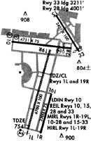
Runways
Runway Summary
| Runways: | 02L/20R 02R/20L 10/28 15/33 |
| Longest Runway: | 02L/20R is 7571 ft (2308 m) long |
| Runways with an Instrument Approach: | 02L, 10 |
DPA Airport Runway Details
| Runway 02L/20R | 7571 ft x 150 ft (2308 m x 46 m) | |
| Runway Length Source: | 3RD PARTY SURVEY as of 06/22/2018 | |
| Surface: | Concrete - Good condition - Saw-cut or plastic grooved | |
| Runway Edge Lights: | High Intensity | |
Runway Weight Bearing Capacity (in thousands of pounds) |
||
| Single Wheel Landing Gear: | 30.0 | |
| Dual Wheel Landing Gear: | 45.0 | |
Runway 02L |
Runway 20R |
|
Elevation: |
750.8 | 755.5 |
Latitude: |
41-53-38.5099N | 41-54-51.0750N |
Longitude: |
088-15-12.7655W | 088-14-48.5213W |
|
Runway True Alignment: |
014 | 194 |
ILS Type: |
ILS | |
Glide Path Angle: |
0.0 degrees | 3.0 degrees |
Runway Markings Type: |
Precision Instrument | Precision Instrument |
Runway Markings Condition: |
Good | Good |
Visual Glide Slope Indicators: |
4-Light PAPI On Left Side Of Runway | |
Runway Visual Range (RVR): |
Touchdown | Rollout |
Approach Light System: |
1,400 Foot Medium Intensity Approach Lighting System With Runway Alignment Indicator Lights | |
Touchdown Lights: |
Yes | No |
Centerline Lights: |
Yes | Yes |
Threshold Crossing Height: |
40 |
| Runway 02R/20L | 6451 ft x 100 ft (1966 m x 30 m) | |
| Runway Length Source: | 3RD PARTY SURVEY as of 06/22/2018 | |
| Surface: | Concrete - Good condition - Saw-cut or plastic grooved | |
| Runway Edge Lights: | Medium Intensity | |
Runway Weight Bearing Capacity (in thousands of pounds) |
||
| Single Wheel Landing Gear: | 30.0 | |
| Dual Wheel Landing Gear: | 45.0 | |
Runway 02R |
Runway 20L |
|
Elevation: |
750.5 | 758.5 |
Latitude: |
41-53-36.0767N | 41-54-37.9008N |
Longitude: |
088-14-59.7123W | 088-14-39.0567W |
|
Runway True Alignment: |
014 | 194 |
Glide Path Angle: |
0.0 degrees | 0.0 degrees |
Traffic Pattern: |
Right | |
Runway Markings Type: |
Nonprecision Instrument | Nonprecision Instrument |
Runway Markings Condition: |
Good | Good |
REIL: |
No | No |
| Runway 10/28 | 4750 ft x 75 ft (1448 m x 23 m) | |
| Runway Length Source: | 3RD PARTY SURVEY as of 06/22/2018 | |
| Surface: | Concrete - Good condition - Saw-cut or plastic grooved | |
| Runway Edge Lights: | High Intensity | |
Runway Weight Bearing Capacity (in thousands of pounds) |
||
| Single Wheel Landing Gear: | 30.0 | |
| Dual Wheel Landing Gear: | 45.0 | |
Runway 10 |
Runway 28 |
|
Elevation: |
753.3 | 755.9 |
Latitude: |
41-54-48.5202N | 41-54-43.5988N |
Longitude: |
088-15-30.5506W | 088-14-28.0750W |
|
Runway True Alignment: |
096 | 276 |
ILS Type: |
ILS | |
Glide Path Angle: |
3.0 degrees | 3.0 degrees |
Traffic Pattern: |
Left | Left |
Runway Markings Type: |
Precision Instrument | Precision Instrument |
Runway Markings Condition: |
Good | Good |
Object at End: |
BLDG | |
Object Height: |
34 | |
Distance from End: |
1743 | |
Visual Glide Slope Indicators: |
4-Box VASI On Left Side Of Runway | 4-Light PAPI On Left Side Of Runway |
REIL: |
Yes | Yes |
Threshold Crossing Height: |
50 | 40 |
| Runway 15/33 | 3399 ft x 100 ft (1036 m x 30 m) | |
| Runway Length Source: | 3RD PARTY SURVEY as of 06/22/2018 | |
| Surface: | Concrete - Good condition - No special surface treatment | |
| Runway Edge Lights: | Medium Intensity | |
Runway Weight Bearing Capacity (in thousands of pounds) |
||
| Single Wheel Landing Gear: | 30.0 | |
| Dual Wheel Landing Gear: | 45.0 | |
| Dual Tandem Wheel Landing Gear: | 100.0 | |
Runway 15 |
Runway 33 |
|
Elevation: |
756.9 | 757.6 |
Latitude: |
41-55-09.2036N | 41-54-40.8666N |
Longitude: |
088-14-44.6365W | 088-14-20.5265W |
|
Runway True Alignment: |
148 | 328 |
Glide Path Angle: |
3.9 degrees | 0.0 degrees |
Traffic Pattern: |
Left | Left |
Runway Markings Type: |
Basic | Basic |
Runway Markings Condition: |
Good | Good |
Object at End: |
TREE | TREE |
Object Height: |
87 | 54 |
Distance from End: |
1750 | 893 |
Visual Glide Slope Indicators: |
4-Light PAPI On Right Side Of Runway | |
REIL: |
Yes | Yes |
Threshold Crossing Height: |
42 | |
Threshold Elevation: |
757.8 | |
Displaced Threshold: |
190 | |
Threshold Latitude: |
41-54-42.4501N | |
Threshold Longitude: |
088-14-21.8734W |
Services
Fuel Available: |
100LL, Jet A |
Landing Fees: |
Yes |
Parking: |
Hangars and tiedowns available |
Other Services: |
Meeting Rooms, Gournet Deli Shop, Picnic facilities, Horseback Riding, Swimming |
Maps & Diagrams
DPA Sectional
Flight Planning
at skyvector.com
at skyvector.com