Location
Latitude: |
41-01-07.8000N (41.018833) |
Longitude: |
089-23-08.8000W (-89.385778) |
Elevation: |
584.5 feet MSL (178 m MSL) |
Magnetic Variation: |
2.7 W (as of April 2024 from WMM2020 model) |
Time Zone: |
UTC -6.0 (Standard Time) UTC -5.0 (Daylight Savings Time) |
From City: |
01 N.M. E of Lacon, Illinois |
Found On: |
Chicago Chart |
FAA Region: |
AGL |
Contacts
Manager: |
Publicly owned: |
| JOE TROGLIO 1315 IL-17, PO BOX 38 LACON, IL 61540 309-246-2870 |
MARSHALL COUNTY 122 N PRAIRIE ST LACON, IL 61540 309-246-3667 |
Operations
Airport Status: |
Operational |
Facility Use: |
Public |
Type: |
Airport |
Activation Date: |
05/1951 |
Control tower: |
No |
Attendance (Months/Days/Hours): |
Months/Days/Hours ALL/ALL/0800-1700 |
Boundary ARTCC: |
ZAU (Chicago) |
Responsible ARTCC: |
ZAU (Chicago) |
Lighting Schedule: |
SEE RMK |
Segmented Circle Indicator: |
Yes |
Traffic Pattern Altitude (MSL): |
1584 feet (483 m) |
NOTAMs Facility: |
C75 |
NOTAM-D Service: |
Yes |
International Airport of Entry: |
No |
Customs Landing Rights: |
No |
Military Landing Rights: |
Yes |
Civil/Military Joint Use: |
No |
Based Aircraft
| Single Engine: | 48 |
| Multi Engine: | 1 |
Annual Operations (as of 04/30/2022)
| Total Operations: | 18900 | |
| Air Taxi: | 1000 | 5.3% |
| GA Local: | 12000 | 63.5% |
| GA Itinerant: | 5500 | 29.1% |
| Military Aircraft: | 400 | 2.1% |
Communications
| CTAF: | 122.800 |
| Unicom: | 122.800 |
| AWOS-3: | 119.425 (309-246-3089) |
- APCH/DEP SVC PRVDD BY CHICAGO ARTCC (ZAU) ON FREQS 124.55/307.125 (BRADFORD RCAG).
Fixed Based Operators (FBOs) & Fuel
(Click on a business for detail)
Please help us keep this information up to date. This is a FREE SERVICE just like everything else on Airport Guide! If you see that a business needs to be added, modified, or deleted please fill out our Update Form.
To add, modify, or delete a business click here.
Please help us keep this information up to date. This is a FREE SERVICE just like everything else on Airport Guide! If you see that a business needs to be added, modified, or deleted please fill out our Update Form.
Area Code: 309 |
| Business Name | Frequency | Phone | Fuel Grade |
|---|---|---|---|
| Lacon Aero Service, Inc.
Update FBO info |
Unicom 122.8 | 246-3700 | 100LL, Jet A |

|
AvFuel | 100LL - 2.75 USD per gallon on 9/8/01 |
24 Hour Self Serve Credit Card Pumps |
Flight Service Stations
| Primary | Alternate | |
| FSS on Field: | N | |
| FSS Name (ID): | Kankakee(IKK) | |
| Frequency: | ||
| Toll Free Phone: | 1-800-WX-BRIEF |
Instrument Procedures / Charts
FAA Terminal Procedures valid from 0901Z 03/21/24 to 0901Z 04/18/24.
There are various types of charts available for an airport. They are listed in the Page Type column. Here is a legend for those types:
APD - Airport Diagram
DP - Departure Procedure Charts
HOT - Hot Spots
IAP - Instrument Approach Procedure Charts
MIN - Minimums
STAR - Standard Terminal Arrival Charts
| Page Type | Page Name | Volume | Action Since Last Cycle |
|---|---|---|---|
| IAP | RNAV (GPS) RWY 13 | EC-3 | |
| IAP | VOR RWY 13 | EC-3 | |
| MIN | ALTERNATE MINIMUMS | EC-3 | |
| MIN | TAKEOFF MINIMUMS | EC-3 |
Terminal Procedures are only available for airports in several countries with more being added all the time. If you are looking for a specific country's charts, please send an email to support(at)airportguide.com stating the country name. This will be used to prioritize the implementation.
Navigation Aids (Navaids) near C75
| Dist (NM) | ID | Morse Code | Name | Type | Freq | True Hdg | Mag Hdg |
|---|---|---|---|---|---|---|---|
| 12.4 | BDF | _ . . . _ . . . . _ . | Bradford | VORTAC | 114.70 | 312 | 315 |
| 26.5 | PI | . _ _ . . . | Tungg | NDB | 356 | 200 | 203 |
| 27.5 | PIA | . _ _ . . . . _ | Peoria | VORTAC | 115.20 | 222 | 225 |
| 31.6 | OIX | _ _ _ . . _ . . _ | Ottawa | NDB | 266 | 49 | 52 |
| 31.9 | PNT | . _ _ . _ . _ | Pontiac | VOR-DME | 109.60 | 111 | 114 |
| 36.0 | LH | . _ . . . . . . | Egrow | NDB | 334 | 139 | 142 |
| 38.3 | BMI | _ . . . _ _ . . | Bloomington | DME | 108.2 | 147 | 150 |
| 41.5 | CTK | _ . _ . _ _ . _ | Canton | NDB | 236 | 229 | 231 |
| 45.3 | BOZ | _ . . . _ _ _ _ _ . . | Whiteside | NDB | 254 | 336 | 339 |
| 47.8 | GBG | _ _ . _ . . . _ _ . | Galesburg | DME | 109.8 | 264 | 266 |
| 51.6 | AAA | . _ . _ . _ | Abraham | NDB | 329 | 177 | 180 |
| 57.1 | PLL | . _ _ . . _ . . . _ . . | Polo | VOR-DME | 111.20 | 353 | 356 |
| 57.6 | JOT | . _ _ _ _ _ _ _ | Joliet | VOR-DME | 112.30 | 56 | 59 |
| 59.4 | MZV | _ _ _ _ . . . . . _ | Moline | VOR-DME | 114.40 | 288 | 290 |
| 61.3 | JZY | . _ _ _ _ _ . . _ . _ _ | Macomb | NDB | 251 | 241 | 243 |
| 61.4 | RBS | . _ . _ . . . . . . | Roberts | VOR-DME | 116.80 | 114 | 117 |
| 63.1 | FN | . . _ . _ . | Hillz | NDB | 517 | 314 | 316 |
| 64.5 | CVA | _ . _ . . . . _ . _ | Davenport | VORTAC | 113.80 | 310 | 312 |
| 64.7 | DVN | _ . . . . . _ _ . | Davenport Municipal | VOT | 111.80 | 303 | 305 |
| 67.0 | RF | . _ . . . _ . | Gilmy | NDB | 275 | 10 | 13 |
Nearby Airports with Fuel
Notices to Airmen (NOTAMS)
Remarks
| A110-1 | RY 31 DEPARTURES ENCOURAGED TO BEGIN RIGHT TURN AS SOON AS PRACTICAL FOR NOISE ABATEMENT |
| A110-2 | FOR CD CTC CHICAGO ARTCC AT 630-906-8921. |
| A16 | CELL PHONE: 309-863-5216 |
| A81-APT | ACTVT MIRL RY 13/31; REIL RY 13 & PAPI RY 31 - CTAF. |
Runways
Runway Summary
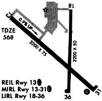
| Runways: | 13/31 18/36 |
| Longest Runway: | 13/31 is 4003 ft (1220 m) long |
| Runways with an Instrument Approach: |
C75 Seaplane Base Runway Details
| Runway 13/31 | 4003 ft x 75 ft (1220 m x 23 m) | |
| Runway Length Source: | 3RD PARTY SURVEY as of 03/08/2014 | |
| Surface: | Asphalt - Good condition - No special surface treatment | |
| Runway Edge Lights: | Medium Intensity | |
Runway 13 |
Runway 31 |
|
Elevation: |
538.5 | 584.5 |
Latitude: |
41-01-18.4776N | 41-00-54.0500N |
Longitude: |
089-23-29.6968W | 089-22-48.6361W |
|
Runway True Alignment: |
128 | 308 |
Glide Path Angle: |
0.0 degrees | 4.0 degrees |
Traffic Pattern: |
Right | |
Runway Markings Type: |
Nonprecision Instrument | Nonprecision Instrument |
Runway Markings Condition: |
Good | Good |
Object at End: |
GND | |
Object Height: |
56 | |
Distance from End: |
1336 | |
Object Centerline Offset: |
0 ft. left and right of centerline | |
Visual Glide Slope Indicators: |
4-Light PAPI On Left Side Of Runway | |
REIL: |
Yes | |
Threshold Crossing Height: |
20 |
| Runway 18/36 | 2199 ft x 50 ft (670 m x 15 m) | |
| Runway Length Source: | 3RD PARTY SURVEY as of 03/08/2014 | |
| Surface: | Asphalt - Good condition - No special surface treatment | |
| Runway Edge Lights: | Low Intensity | |
Runway Weight Bearing Capacity (in thousands of pounds) |
||
| Single Wheel Landing Gear: | 4.0 | |
Runway 18 |
Runway 36 |
|
Elevation: |
554.2 | 547.7 |
Latitude: |
41-01-21.3180N | 41-00-59.5990N |
Longitude: |
089-23-07.6656W | 089-23-08.3412W |
|
Runway True Alignment: |
181 | 001 |
Glide Path Angle: |
0.0 degrees | 0.0 degrees |
Traffic Pattern: |
Left | Left |
Runway Markings Type: |
Basic | Basic |
Runway Markings Condition: |
Good | Good |
Object at End: |
ROAD | |
Object Height: |
9 | |
Distance from End: |
334 | |
Object Centerline Offset: |
0 ft. left and right of centerline |
Services
Airframe Repair: |
Minor |
Powerplant Repair: |
Minor |
Bottled Oxygen: |
None |
Bulk Oxygen: |
None |
Fuel Available: |
100LL |
Landing Fees: |
No |
Parking: |
Tiedowns available |
Maps & Diagrams
C75 Sectional
Flight Planning
at skyvector.com
at skyvector.com