Location
Latitude: |
42-09-12.2200N (42.153394) |
Longitude: |
079-15-28.8820W (-79.258023) |
Elevation: |
1723.3 feet MSL (525 m MSL) |
Magnetic Variation: |
10 W (as of April 2024 from WMM2020 model) |
Time Zone: |
UTC -5.0 (Standard Time) UTC -4.0 (Daylight Savings Time) |
From City: |
03 N.M. N of Jamestown, New York |
Found On: |
Detroit Chart |
FAA Region: |
AEA |
Contacts
Manager: |
Publicly owned: |
| SHANNON BARNHART 3163 AIRPORT DR JAMESTOWN, NY 14701 716-484-0204 |
CHAUTAUQUA COUNTY NORTH ERIE ST., COUNTY OFFICE BLDGS MAYVILLE, NY 14757 716-753-4000 |
Operations
Airport Status: |
Operational |
Facility Use: |
Public |
Type: |
Airport |
Activation Date: |
12/1938 |
Control tower: |
No |
Attendance (Months/Days/Hours): |
Months/Days/Hours ALL/M-F/0600-1430 LCL |
Boundary ARTCC: |
ZOB (Cleveland) |
Responsible ARTCC: |
ZOB (Cleveland) |
Lighting Schedule: |
SEE RMK |
Segmented Circle Indicator: |
Yes |
Traffic Pattern Altitude (MSL): |
2723 feet (830 m) |
NOTAMs Facility: |
JHW |
NOTAM-D Service: |
Yes |
International Airport of Entry: |
No |
Customs Landing Rights: |
No |
Military Landing Rights: |
Yes |
Civil/Military Joint Use: |
No |
Aircraft Rescue and Firefighting: |
Class IV ARFF Index: A Air Carrier Service: Scheduled Certification Date: 05/1973 |
Based Aircraft
| Single Engine: | 15 |
| Multi Engine: | 5 |
| GA Helicopters: | 1 |
Annual Operations (as of 08/31/2022)
| Total Operations: | 9445 | |
| GA Local: | 6881 | 72.9% |
| GA Itinerant: | 2551 | 27.0% |
| Military Aircraft: | 13 | 0.1% |
Communications
| CTAF: | 122.975 |
| Unicom: | 122.975 |
| Approach: | BUFFALO 126.05 CLEVELAND ARTCC |
| Departure: | BUFFALO 126.05 CLEVELAND ARTCC |
| AWOS-3PT: | 118.425 (716-664-6005) |
- APCH/DEP SVC PRVDD BY BUFFALO APCH (BUF) ON 126.05 0600-0000. APCH/DEP SVC PRVDD BY CLEVELAND ARTCC (ZOB) ON FREQ 127.075/292.175 (WATERFORD RCAG) 0000-0600.
Fixed Based Operators (FBOs) & Fuel
(Click on a business for detail)
Please help us keep this information up to date. This is a FREE SERVICE just like everything else on Airport Guide! If you see that a business needs to be added, modified, or deleted please fill out our Update Form.
To add, modify, or delete a business click here.
Please help us keep this information up to date. This is a FREE SERVICE just like everything else on Airport Guide! If you see that a business needs to be added, modified, or deleted please fill out our Update Form.
Area Code: 716 |
| Business Name | Frequency | Phone | Fuel Grade |
|---|---|---|---|
| United Jet A Center
Update FBO info |
Unicom 122.775 | 483-0111 | 100LL, Jet A |
Flight Service Stations
| Primary | Alternate | |
| FSS on Field: | N | |
| FSS Name (ID): | Buffalo(BUF) | |
| Frequency: | ||
| Toll Free Phone: | 1-800-WX-BRIEF |
Instrument Procedures / Charts
FAA Terminal Procedures valid from 0901Z 03/21/24 to 0901Z 04/18/24.
There are various types of charts available for an airport. They are listed in the Page Type column. Here is a legend for those types:
APD - Airport Diagram
DP - Departure Procedure Charts
HOT - Hot Spots
IAP - Instrument Approach Procedure Charts
MIN - Minimums
STAR - Standard Terminal Arrival Charts
| Page Type | Page Name | Volume | Action Since Last Cycle |
|---|---|---|---|
| APD | AIRPORT DIAGRAM | NE-2 | |
| IAP | ILS OR LOC RWY 25 | NE-2 | |
| IAP | RNAV (GPS) RWY 07 | NE-2 | |
| IAP | RNAV (GPS) RWY 13 | NE-2 | |
| IAP | RNAV (GPS) RWY 25 | NE-2 | |
| IAP | RNAV (GPS) RWY 31 | NE-2 | |
| IAP | VOR RWY 25 | NE-2 | |
| MIN | ALTERNATE MINIMUMS | NE-2 | |
| MIN | TAKEOFF MINIMUMS | NE-2 |
Terminal Procedures are only available for airports in several countries with more being added all the time. If you are looking for a specific country's charts, please send an email to support(at)airportguide.com stating the country name. This will be used to prioritize the implementation.
Navigation Aids (Navaids) near JHW
| Dist (NM) | ID | Morse Code | Name | Type | Freq | True Hdg | Mag Hdg |
|---|---|---|---|---|---|---|---|
| 6.4 | JHW | . _ _ _ . . . . . _ _ | Jamestown | VOR-DME | 114.70 | 70 | 80 |
| 20.2 | DKK | _ . . _ . _ _ . _ | Dunkirk | DME | 116.2 | 357 | 367 |
| 22.6 | ORJ | _ _ _ . _ . . _ _ _ | Corry | NDB | 258 | 230 | 240 |
| 27.4 | TDT | _ _ . . _ | Tidioute | DME | 117.6 | 195 | 205 |
| 36.0 | BFD | _ . . . . . _ . _ . . | Bradford | DME | 116.6 | 127 | 137 |
| 37.7 | CQD | _ . _ . _ _ . _ _ . . | Cascade | NDB | 372 | 267 | 277 |
| 41.8 | LYS | . _ . . _ . _ _ . . . | Olean | NDB | 360 | 78 | 88 |
| 44.9 | ERI | . . _ . . . | Esmer | NDB | 349 | 261 | 271 |
| 46.8 | ERI | . . _ . . . | Erie | TACAN | 109.40 | 260 | 270 |
| 47.4 | GB | _ _ . _ . . . | Plazz | NDB | 204 | 24 | 34 |
| 50.6 | FKL | . . _ . _ . _ . _ . . | Franklin | VOR | 109.60 | 212 | 222 |
| 52.5 | BUF | _ . . . . . _ . . _ . | Buffalo | VOT | 109.00 | 25 | 35 |
| 53.8 | BUF | _ . . . . . _ . . _ . | Buffalo | DME | 116.4 | 29 | 39 |
| 56.1 | ELZ | . . _ . . _ _ . . | Wellsville | DME | 115.85 | 93 | 103 |
| 57.5 | BU | _ . . . . . _ | Klump | NDB | 231 | 27 | 37 |
| 59.0 | IAG | . . . _ _ _ . | Niagara Falls | TACAN | 111.00 | 12 | 22 |
| 59.6 | SN | St. Catharines | NDB | 408 | 0 | 10 | |
| 60.3 | IA | . . . _ | Kathi | NDB | 329 | 17 | 27 |
| 61.1 | CIP | _ . _ . . . . _ _ . | Clarion | DME | 112.9 | 188 | 198 |
| 64.0 | ZHM | Binbrook | NDB | 266 | 338 | 348 |
Nearby Airports with Fuel
Notices to Airmen (NOTAMS)
Remarks
| A110-1 | DEER AND BIRDS ON & INVOF ARPT. |
| A110-3 | SNOW REMOVAL OPS AVBL DURING NORMAL ATTENDANCE HRS; SNOW REMOVAL MAY BE LIMITED ON HOLIDAYS & WEEKENDS. |
| A110-4 | FOR CD CTC BUFFALO APCH AT 716-626-6920, WHEN APCH CLSD CTC CLEVELAND ARTCC AT 440-774-0232. |
| A110-5 | ATTENDANCE HRS AND SERVICES AVAILABLE ARE SUBJECT TO CHANGE, CALL AIRPORT MANAGER AT 716-484-0204 TO CONFIRM. |
| A110-7 | RWY/TWY CONDITIONS NOT MONITORED OUTSIDE OF NORMAL ATTENDANCE HRS. |
| A110-8 | 24 HR PPR FOR AIR CARRIER OPS WITH MORE THAN 9 PAX SEATS. CONTACT ARPT MGR AT 716-484-0204. FOR EMERGENCIES AFTER HRS, CALL 911 FOR MUTUAL AID SERVICE. |
| A110-9 | ARFF INDEX B CPBL. |
| A24 | LNDG FEE MULTI-ENGINE ACFT ONLY. |
| A39-07/25 | PCR VALUE: 250/F/B/W/T |
| A39-13/31 | PCR VALUE: 148/F/C/W/T |
| A81-APT | ACTVT MALSR RWY 25; REIL RWY 31; PAPI RWY 13 & 31; VASI RWY 07; HIRL RWY 07/25; MIRL RWY 13/31 & TWY LGTS - CTAF. |
| E111 | EXISTED PRIOR TO 1959. |
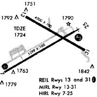
Runways
Runway Summary
| Runways: | 07/25 13/31 |
| Longest Runway: | 07/25 is 5300 ft (1615 m) long |
| Runways with an Instrument Approach: | 25 |
JHW Airport Runway Details
| Runway 07/25 | 5300 ft x 100 ft (1615 m x 30 m) | |
| Runway Length Source: | 3RD PARTY SURVEY as of 12/06/2022 | |
| Surface: | Asphalt - Excellent condition - Saw-cut or plastic grooved | |
| Runway Edge Lights: | High Intensity | |
Runway Weight Bearing Capacity (in thousands of pounds) |
||
| Single Wheel Landing Gear: | 57.0 | |
| Dual Wheel Landing Gear: | 95.0 | |
| Dual Tandem Wheel Landing Gear: | 125.0 | |
Runway 07 |
Runway 25 |
|
Elevation: |
1720.6 | 1718.6 |
Latitude: |
42-08-53.3570N | 42-09-20.3595N |
Longitude: |
079-16-05.2150W | 079-15-04.9448W |
|
Runway True Alignment: |
059 | 239 |
ILS Type: |
ILS/DME | |
Glide Path Angle: |
3.0 degrees | 0.0 degrees |
Traffic Pattern: |
Left | Left |
Runway Markings Type: |
Nonprecision Instrument | Precision Instrument |
Runway Markings Condition: |
Good | Good |
Visual Glide Slope Indicators: |
4-Box VASI On Left Side Of Runway | |
Approach Light System: |
1,400 Foot Medium Intensity Approach Lighting System With Runway Alignment Indicator Lights | |
Threshold Crossing Height: |
52 | |
Declared Distances |
||
Take Off Run Avbl. (TORA): |
5300 | 5300 |
Take Off Distance Avbl. (TODA): |
5300 | 5300 |
Actual Stop Dist. Avbl. (ASDA): |
5300 | 5300 |
Landing Dist. Avbl. (LDA): |
5300 | 5300 |
| Runway 13/31 | 4499 ft x 100 ft (1371 m x 30 m) | |
| Runway Length Source: | 3RD PARTY SURVEY as of 12/06/2022 | |
| Surface: | Asphalt - Excellent condition - No special surface treatment | |
| Runway Edge Lights: | Medium Intensity | |
Runway Weight Bearing Capacity (in thousands of pounds) |
||
| Single Wheel Landing Gear: | 31.0 | |
| Dual Wheel Landing Gear: | 56.0 | |
Runway 13 |
Runway 31 |
|
Elevation: |
1723.3 | 1707.2 |
Latitude: |
42-09-29.2882N | 42-09-07.7788N |
Longitude: |
079-15-47.7102W | 079-14-55.4497W |
|
Runway True Alignment: |
119 | 299 |
Glide Path Angle: |
3.0 degrees | 3.0 degrees |
Traffic Pattern: |
Left | Left |
Runway Markings Type: |
Nonprecision Instrument | Nonprecision Instrument |
Runway Markings Condition: |
Good | Good |
Object at End: |
TREE | BLDG |
Object Height: |
69 | 61 |
Distance from End: |
1400 | 1200 |
Visual Glide Slope Indicators: |
4-Light PAPI On Left Side Of Runway | 4-Light PAPI On Left Side Of Runway |
REIL: |
Yes | |
Threshold Crossing Height: |
45 | 51 |
Declared Distances |
||
Take Off Run Avbl. (TORA): |
4499 | 4499 |
Take Off Distance Avbl. (TODA): |
4499 | 4499 |
Actual Stop Dist. Avbl. (ASDA): |
4499 | 4499 |
Landing Dist. Avbl. (LDA): |
4499 | 4499 |
Services
Airframe Repair: |
Major |
Powerplant Repair: |
Major |
Bottled Oxygen: |
None |
Bulk Oxygen: |
High Pressure |
Fuel Available: |
100LL, Jet A-1+ |
Landing Fees: |
No |
Parking: |
Hangars and tiedowns available |
Maps & Diagrams
JHW Sectional
Flight Planning
at skyvector.com
at skyvector.com