Location
Latitude: |
40-19-44.0820N (40.328912) |
Longitude: |
082-31-33.8540W (-82.526071) |
Elevation: |
1191.6 feet MSL (363 m MSL) |
Magnetic Variation: |
7.6 W (as of May 2024 from WMM2020 model) |
Time Zone: |
UTC -5.0 (Standard Time) UTC -4.0 (Daylight Savings Time) |
From City: |
04 N.M. SW of Mount Vernon, Ohio |
Found On: |
Detroit Chart |
FAA Region: |
AGL |
Contacts
Manager: |
Publicly owned: |
| JOSH WYNN 6481 KINNEY RD MOUNT VERNON, OH 43050-9301 740-397-9647 |
KNOX CO ARPT AUTHORITY 6481 KINNEY RD MOUNT VERNON, OH 43050-9301 740-397-9647 |
Operations
Airport Status: |
Operational |
Facility Use: |
Public |
Type: |
Airport |
Control tower: |
No |
Attendance (Months/Days/Hours): |
Months/Days/Hours ALL/MON-FRI/0700-1700 |
Boundary ARTCC: |
ZID (Indianapolis) |
Responsible ARTCC: |
ZID (Indianapolis) |
Lighting Schedule: |
SEE RMK |
Segmented Circle Indicator: |
No |
Traffic Pattern Altitude (MSL): |
2192 feet (668 m) |
NOTAMs Facility: |
CLE |
NOTAM-D Service: |
Yes |
International Airport of Entry: |
No |
Customs Landing Rights: |
No |
Military Landing Rights: |
Yes |
Civil/Military Joint Use: |
No |
Based Aircraft
| Single Engine: | 71 |
| Multi Engine: | 3 |
| Jet Engine: | 1 |
Annual Operations (as of 08/02/2023)
| Total Operations: | 24150 | |
| Air Taxi: | 500 | 2.1% |
| GA Local: | 14000 | 58.0% |
| GA Itinerant: | 9500 | 39.3% |
| Military Aircraft: | 150 | 0.6% |
Communications
| CTAF: | 123.050 |
| Unicom: | 123.050 |
| Clearance Del.: | 119.45 119.45 119.45 |
| Approach: | COLUMBUS |
| Departure: | COLUMBUS |
| AWOS-3: | 126.05 (740-397-6297) |
Fixed Based Operators (FBOs) & Fuel
(Click on a business for detail)
Please help us keep this information up to date. This is a FREE SERVICE just like everything else on Airport Guide! If you see that a business needs to be added, modified, or deleted please fill out our Update Form.
To add, modify, or delete a business click here.
Please help us keep this information up to date. This is a FREE SERVICE just like everything else on Airport Guide! If you see that a business needs to be added, modified, or deleted please fill out our Update Form.
Area Code: 740 |
| Business Name | Frequency | Phone | Fuel Grade |
|---|---|---|---|
| Knox County Airport
Update FBO info |
Unicom 123.05 | 397-9647 | 100LL, Jet A |
Flight Service Stations
| Primary | Alternate | |
| FSS on Field: | N | |
| FSS Name (ID): | Cleveland(CLE) | |
| Frequency: | ||
| Toll Free Phone: | 1-800-WX-BRIEF |
Instrument Procedures / Charts
FAA Terminal Procedures valid from 0901Z 03/21/24 to 0901Z 04/18/24.
There are various types of charts available for an airport. They are listed in the Page Type column. Here is a legend for those types:
APD - Airport Diagram
DP - Departure Procedure Charts
HOT - Hot Spots
IAP - Instrument Approach Procedure Charts
MIN - Minimums
STAR - Standard Terminal Arrival Charts
| Page Type | Page Name | Volume | Action Since Last Cycle |
|---|---|---|---|
| IAP | RNAV (GPS) RWY 10 | EC-2 | |
| IAP | RNAV (GPS) RWY 28 | EC-2 | |
| IAP | VOR-A | EC-2 | |
| MIN | ALTERNATE MINIMUMS | EC-2 | |
| MIN | TAKEOFF MINIMUMS | EC-2 |
Terminal Procedures are only available for airports in several countries with more being added all the time. If you are looking for a specific country's charts, please send an email to support(at)airportguide.com stating the country name. This will be used to prioritize the implementation.
Navigation Aids (Navaids) near 4I3
| Dist (NM) | ID | Morse Code | Name | Type | Freq | True Hdg | Mag Hdg |
|---|---|---|---|---|---|---|---|
| 11.0 | APE | . _ . _ _ . . | Appleton | VORTAC | 116.70 | 194 | 202 |
| 18.4 | HEH | . . . . . . . . . | Newark | NDB | 524 | 171 | 179 |
| 23.1 | CM | _ . _ . _ _ | Sumie | NDB | 391 | 207 | 215 |
| 26.0 | CMH | _ . _ . _ _ . . . . | Port Columbus | VOT | 111.00 | 219 | 226 |
| 26.5 | MF | _ _ . . _ . | Manns | NDB | 372 | 7 | 15 |
| 30.0 | CHC | _ . _ . . . . . _ . _ . | Grens | NDB | 272 | 230 | 237 |
| 30.0 | BUD | _ . . . . . _ _ . . | Buckeye | VOR | 109.80 | 305 | 312 |
| 30.4 | LC | . _ . . _ . _ . | Pickl | NDB | 376 | 207 | 214 |
| 32.5 | MLR | _ _ . _ . . . _ . | Millersburg/Dcmsnd | NDB | 382 | 66 | 74 |
| 32.5 | MFD | _ _ . . _ . _ . . | Mansfield | VORTAC | 108.80 | 354 | 362 |
| 34.4 | OS | _ _ _ . . . | Fuler | NDB | 515 | 243 | 250 |
| 36.3 | LCK | . _ . . _ . _ . _ . _ | Rickenbacker | TACAN | 69X | 210 | 217 |
| 37.2 | ZZV | _ _ . . _ _ . . . . . _ | Zanesville | VOR-DME | 114.95 | 128 | 136 |
| 37.7 | HRA | . . . . . _ . . _ | Zanesville | NDB | 204 | 132 | 140 |
| 40.0 | AAU | . _ . _ . . _ | Ashland | NDB | 329 | 17 | 25 |
| 41.8 | DD | _ . . _ . . | Cobbs | NDB | 253 | 213 | 220 |
| 43.7 | BU | _ . . . . . _ | Boutn | NDB | 230 | 225 | 232 |
| 48.4 | CTW | _ . _ . _ . _ _ | Newcomerstown | DME | 111.8 | 96 | 104 |
| 52.4 | XUB | _ . . _ . . _ _ . . . | Yellow Bud | VOR | 112.50 | 203 | 210 |
| 52.8 | RUV | . _ . . . _ . . . _ | Rushsylvania | NDB | 326 | 278 | 285 |
Nearby Airports with Fuel
Notices to Airmen (NOTAMS)
Remarks
| A110-1 | DEER, BIRDS, & OTR WILDLIFE ON & INVOF ARPT. |
| A14 | KNOXAIRPORT@EMBARQMAIL.COM. |
| A17 | 24 HR PN FOR ATNDNC AFT HRS - CALL AMGR. |
| A70-FUEL-10 | 0LL FUEL AVBL H24 SELF SER VIA CREDIT CARD. |
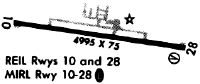
| A81-APT | ACTVT REIL RWY 10 & 28; MIRL RWY 10/28 - CTAF. PAPI RWY 10 & 28 OPR CONSLY. |
Runways
Runway Summary
| Runways: | 10/28 |
| Longest Runway: | 10/28 is 5504 ft (1678 m) long |
| Runways with an Instrument Approach: |
4I3 Airport Runway Details
| Runway 10/28 | 5504 ft x 100 ft (1678 m x 30 m) | |
| Runway Length Source: | 3RD PARTY SURVEY as of 10/21/2020 | |
| Surface: | Asphalt - Good condition - Saw-cut or plastic grooved | |
| Runway Edge Lights: | Medium Intensity | |
Runway Weight Bearing Capacity (in thousands of pounds) |
||
| Single Wheel Landing Gear: | 55.0 | |
| Dual Wheel Landing Gear: | 100.0 | |
Runway 10 |
Runway 28 |
|
Elevation: |
1187.3 | 1184.4 |
Latitude: |
40-19-47.7187N | 40-19-40.4430N |
Longitude: |
082-32-09.0666W | 082-30-58.6432W |
|
Runway True Alignment: |
098 | 278 |
Glide Path Angle: |
3.0 degrees | 3.0 degrees |
Traffic Pattern: |
Left | Left |
Runway Markings Type: |
Nonprecision Instrument | Nonprecision Instrument |
Runway Markings Condition: |
Good | Good |
Object at End: |
TREES | TREES |
Object Height: |
126 | 51 |
Distance from End: |
3188 | 1962 |
Object Centerline Offset: |
60 ft. left of centerline | 65 ft. left of centerline |
Visual Glide Slope Indicators: |
4-Light PAPI On Left Side Of Runway | 4-Light PAPI On Left Side Of Runway |
REIL: |
Yes | Yes |
Touchdown Lights: |
No | No |
Centerline Lights: |
No | No |
Threshold Crossing Height: |
40 | 40 |
Services
Airframe Repair: |
Major |
Powerplant Repair: |
Major |
Bottled Oxygen: |
None |
Bulk Oxygen: |
None |
Fuel Available: |
100LL, Jet A-1, Jet A-1+ |
Landing Fees: |
No |
Parking: |
Hangars and tiedowns available |
Maps & Diagrams
4I3 Sectional
Flight Planning
at skyvector.com
at skyvector.com