Location
Latitude: |
40-21-54.2240N (40.365062) |
Longitude: |
082-29-44.5850W (-82.495718) |
Elevation: |
1041.0 feet MSL (317 m MSL) |
Magnetic Variation: |
7.6 W (as of April 2024 from WMM2020 model) |
Time Zone: |
UTC -5.0 (Standard Time) UTC -4.0 (Daylight Savings Time) |
From City: |
02 N.M. S of Mount Vernon, Ohio |
Found On: |
Detroit Chart |
FAA Region: |
AGL |
Contacts
Manager: |
Privately owned: |
| BRIAN K WYNKOOP 9051 GRANVILLE RD MOUNT VERNON, OH 43050-9411 740-358-2362 |
BRIAN K WYNKOOP 9051 GRANVILLE RD MOUNT VERNON, OH 43050-9411 740-358-2362 |
Operations
Airport Status: |
Operational |
Facility Use: |
Public |
Type: |
Airport |
Activation Date: |
12/1944 |
Control tower: |
No |
Attendance (Months/Days/Hours): |
Months/Days/Hours ALL/MON-SAT/IREG |
Boundary ARTCC: |
ZID (Indianapolis) |
Responsible ARTCC: |
ZID (Indianapolis) |
Lighting Schedule: |
SEE RMK |
Segmented Circle Indicator: |
No |
Traffic Pattern Altitude (MSL): |
2041 feet (622 m) |
NOTAMs Facility: |
CLE |
NOTAM-D Service: |
Yes |
International Airport of Entry: |
No |
Customs Landing Rights: |
No |
Military Landing Rights: |
No |
Civil/Military Joint Use: |
No |
Based Aircraft
| Single Engine: | 10 |
Annual Operations (as of 08/26/2022)
| Total Operations: | 2860 | |
| GA Local: | 2500 | 87.4% |
| GA Itinerant: | 350 | 12.2% |
| Military Aircraft: | 10 | 0.3% |
Communications
| CTAF: | 122.900 |
Fixed Based Operators (FBOs) & Fuel
(Click on a business for detail)
Please help us keep this information up to date. This is a FREE SERVICE just like everything else on Airport Guide! If you see that a business needs to be added, modified, or deleted please fill out our Update Form.
To add, modify, or delete a business click here.
Please help us keep this information up to date. This is a FREE SERVICE just like everything else on Airport Guide! If you see that a business needs to be added, modified, or deleted please fill out our Update Form.
Area Code: 740 |
| Business Name | Frequency | Phone | Fuel Grade |
|---|---|---|---|
| Antique Aircraft Restoration (Waco)
Update FBO info |
393-2243 | 80, 100LL | |
| Flying Koop Aviation
Update FBO info |
Unicom 122.9 | 392-8351 | 80, 100LL |
Flight Service Stations
| Primary | Alternate | |
| FSS on Field: | N | |
| FSS Name (ID): | Cleveland(CLE) | |
| Frequency: | ||
| Toll Free Phone: | 1-800-WX-BRIEF |
Instrument Procedures / Charts
Terminal Procedures are only available for airports in several countries with more being added all the time. If you are looking for a specific country's charts, please send an email to support(at)airportguide.com stating the country name. This will be used to prioritize the implementation.
Navigation Aids (Navaids) near 6G4
| Dist (NM) | ID | Morse Code | Name | Type | Freq | True Hdg | Mag Hdg |
|---|---|---|---|---|---|---|---|
| 13.5 | APE | . _ . _ _ . . | Appleton | VORTAC | 116.70 | 198 | 206 |
| 20.4 | HEH | . . . . . . . . . | Newark | NDB | 524 | 175 | 183 |
| 24.2 | MF | _ _ . . _ . | Manns | NDB | 372 | 5 | 13 |
| 25.6 | CM | _ . _ . _ _ | Sumie | NDB | 391 | 207 | 215 |
| 28.5 | CMH | _ . _ . _ _ . . . . | Port Columbus | VOT | 111.00 | 218 | 225 |
| 30.0 | BUD | _ . . . . . _ _ . . | Buckeye | VOR | 109.80 | 300 | 307 |
| 30.4 | MLR | _ _ . _ . . . _ . | Millersburg/Dcmsnd | NDB | 382 | 69 | 77 |
| 30.5 | MFD | _ _ . . _ . _ . . | Mansfield | VORTAC | 108.80 | 351 | 359 |
| 32.4 | CHC | _ . _ . . . . . _ . _ . | Grens | NDB | 272 | 229 | 236 |
| 33.0 | LC | . _ . . _ . _ . | Pickl | NDB | 376 | 208 | 215 |
| 36.6 | OS | _ _ _ . . . | Fuler | NDB | 515 | 241 | 248 |
| 37.6 | AAU | . _ . _ . . _ | Ashland | NDB | 329 | 17 | 25 |
| 37.6 | ZZV | _ _ . . _ _ . . . . . _ | Zanesville | VOR-DME | 114.95 | 132 | 140 |
| 38.2 | HRA | . . . . . _ . . _ | Zanesville | NDB | 204 | 135 | 143 |
| 38.9 | LCK | . _ . . _ . _ . _ . _ | Rickenbacker | TACAN | 69X | 210 | 217 |
| 44.4 | DD | _ . . _ . . | Cobbs | NDB | 253 | 213 | 220 |
| 46.2 | BU | _ . . . . . _ | Boutn | NDB | 230 | 225 | 232 |
| 47.3 | CTW | _ . _ . _ . _ _ | Newcomerstown | DME | 111.8 | 99 | 107 |
| 53.5 | BSV | _ . . . . . . . . . _ | Briggs | VOR-DME | 112.40 | 64 | 72 |
| 53.8 | RUV | . _ . . . _ . . . _ | Rushsylvania | NDB | 326 | 276 | 283 |
Nearby Airports with Fuel
Notices to Airmen (NOTAMS)
Remarks
| A110-1 | -1 FT DITCH RWY 24 END 0 FT FM LEFT & RIGHT. |
| A110-2 | DEER ON & INVOF ARPT. |
| A110-4 | FOR CD CTC COLUMBUS APCH AT 614-338-8537. |
| A13 | CELL. |
| A16 | OR 740-398-8106. |
| A40-06/24 | NSTD LIRL DUE TO NO THR LGTS. |
| A52-06 | 60 FT TREE, 210 FT DIST, 45 FT R, 3:1. |
| A70-FUEL-10 | 0LL 100LL AVBL ONLY WHEN FLD IS ATNDD; CREDIT CARDS NOT ACPTD. |
| A75 | PRIOR CDN RQRD. |
| A75 1 | ROPES & ANCHORS NOT PRVDD. |
| A81-APT | ACTVT NSTD LIRL - CALL AMGR. |
| A81-BCN | ACTVT ABN - CALL AMGR. |
| E111 | ESTABD BFR 1959. |
Runways
Runway Summary
| Runways: | 06/24 |
| Longest Runway: | 06/24 is 3460 ft (1055 m) long |
| Runways with an Instrument Approach: |
6G4 Airport Runway Details
| Runway 06/24 | 3460 ft x 90 ft (1055 m x 27 m) | |
| Surface: | Turf - Good condition - No special surface treatment | |
| Runway Edge Lights: | Non-standard lighting system Intensity | |
Runway 06 |
Runway 24 |
|
Elevation: |
1041.0 | 1041.0 |
Latitude: |
40-21-46.3200N | 40-22-02.1100N |
Longitude: |
082-30-04.4000W | 082-29-24.7500W |
Glide Path Angle: |
0.0 degrees | 0.0 degrees |
Traffic Pattern: |
Left | Left |
Object at End: |
CROPS | ROAD |
Object Height: |
12 | 16 |
Distance from End: |
48 | 0 |
Object Centerline Offset: |
45 ft. left of centerline | 80 ft. left of centerline |
REIL: |
No | No |
Touchdown Lights: |
No | No |
Centerline Lights: |
No | No |
Services
Airframe Repair: |
None |
Powerplant Repair: |
None |
Bottled Oxygen: |
None |
Bulk Oxygen: |
None |
Fuel Available: |
100LL, Jet A, Jet A-1+ |
Landing Fees: |
No |
Parking: |
Hangars and tiedowns available |
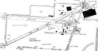
Maps & Diagrams
6G4 Sectional
Flight Planning
at skyvector.com
at skyvector.com