Location
Latitude: |
40-00-26.2500N (40.007292) |
Longitude: |
082-00-48.5250W (-82.013479) |
Elevation: |
790.0 feet MSL (241 m MSL) |
Magnetic Variation: |
7.9 W (as of April 2024 from WMM2020 model) |
Time Zone: |
UTC -5.0 (Standard Time) UTC -4.0 (Daylight Savings Time) |
From City: |
05 N.M. N of Zanesville, Ohio |
Found On: |
Detroit Chart |
FAA Region: |
AGL |
Contacts
Manager: |
Privately owned: |
| C E NORMAN 1200 FAIRVIEW RD ZANESVILLE, OH 43701-9729 740-454-1615 |
C E NORMAN 1200 FAIRVIEW RD ZANESVILLE, OH 43701-9729 740-454-1615 |
Operations
Airport Status: |
Operational |
Facility Use: |
Public |
Type: |
Airport |
Activation Date: |
07/1971 |
Control tower: |
No |
Attendance (Months/Days/Hours): |
Months/Days/Hours ALL/MON-SAT/1000-DUSK |
Boundary ARTCC: |
ZID (Indianapolis) |
Responsible ARTCC: |
ZID (Indianapolis) |
Lighting Schedule: |
SEE RMK |
Segmented Circle Indicator: |
No |
Traffic Pattern Altitude (MSL): |
1790 feet (546 m) |
NOTAMs Facility: |
CLE |
NOTAM-D Service: |
Yes |
Military Landing Rights: |
No |
Civil/Military Joint Use: |
No |
Based Aircraft
| Single Engine: | 42 |
| Multi Engine: | 5 |
Annual Operations (as of 06/14/2022)
| Total Operations: | 8000 | |
| GA Local: | 4000 | 50.0% |
| GA Itinerant: | 4000 | 50.0% |
Communications
| CTAF: | 122.800 |
| Unicom: | 122.800 |
Fixed Based Operators (FBOs) & Fuel
(Click on a business for detail)
Please help us keep this information up to date. This is a FREE SERVICE just like everything else on Airport Guide! If you see that a business needs to be added, modified, or deleted please fill out our Update Form.
To add, modify, or delete a business click here.
Please help us keep this information up to date. This is a FREE SERVICE just like everything else on Airport Guide! If you see that a business needs to be added, modified, or deleted please fill out our Update Form.
Area Code: 614 |
| Business Name | Frequency | Phone | Fuel Grade |
|---|---|---|---|
| Norman Aviation
Update FBO info |
Unicom 122.8 | 454-1615 | 80, 100LL |
| Y-City Flying Service
Update FBO info |
Unicom 122.8 | 454-1615, 453-4438 | 80, 100LL |
Flight Service Stations
| Primary | Alternate | |
| FSS on Field: | N | |
| FSS Name (ID): | Cleveland(CLE) | |
| Frequency: | ||
| Toll Free Phone: | 1-800-WX-BRIEF |
Instrument Procedures / Charts
Terminal Procedures are only available for airports in several countries with more being added all the time. If you are looking for a specific country's charts, please send an email to support(at)airportguide.com stating the country name. This will be used to prioritize the implementation.
Navigation Aids (Navaids) near 42I
| Dist (NM) | ID | Morse Code | Name | Type | Freq | True Hdg | Mag Hdg |
|---|---|---|---|---|---|---|---|
| 6.8 | ZZV | _ _ . . _ _ . . . . . _ | Zanesville | VOR-DME | 114.95 | 125 | 133 |
| 7.4 | HRA | . . . . . _ . . _ | Zanesville | NDB | 204 | 144 | 152 |
| 20.7 | HEH | . . . . . . . . . | Newark | NDB | 524 | 273 | 281 |
| 27.8 | APE | . _ . _ _ . . | Appleton | VORTAC | 116.70 | 288 | 296 |
| 28.0 | CTW | _ . _ . _ . _ _ | Newcomerstown | DME | 111.8 | 61 | 69 |
| 32.7 | MLR | _ _ . _ . . . _ . | Millersburg/Dcmsnd | NDB | 382 | 11 | 19 |
| 34.1 | CM | _ . _ . _ _ | Sumie | NDB | 391 | 268 | 276 |
| 38.6 | LC | . _ . . _ . _ . | Pickl | NDB | 376 | 258 | 266 |
| 40.1 | CMH | _ . _ . _ _ . . . . | Port Columbus | VOT | 111.00 | 269 | 277 |
| 43.8 | LCK | . _ . . _ . _ . _ . _ | Rickenbacker | TACAN | 69X | 254 | 262 |
| 45.0 | JPU | . _ _ _ . _ _ . . . _ | Parkersburg | VOR-DME | 114.45 | 138 | 146 |
| 45.3 | UGS | . . _ _ _ . . . . | University | NDB | 250 | 186 | 194 |
| 46.5 | PKB | . _ _ . _ . _ _ . . . | Marietta Ohio | FAN MARKER | 143 | 151 | |
| 46.7 | CHC | _ . _ . . . . . _ . _ . | Grens | NDB | 272 | 270 | 278 |
| 47.6 | UNI | . . _ _ . . . | Athens | FAN MARKER | 190 | 198 | |
| 47.9 | CFX | _ . _ . . . _ . _ . . _ | Cadiz | NDB | 239 | 72 | 80 |
| 49.0 | DD | _ . . _ . . | Cobbs | NDB | 253 | 251 | 259 |
| 49.6 | MF | _ _ . . _ . | Manns | NDB | 372 | 336 | 344 |
| 51.4 | PK | . _ _ . _ . _ | Versi | NDB | 388 | 151 | 159 |
| 51.4 | BSV | _ . . . . . . . . . _ | Briggs | VOR-DME | 112.40 | 30 | 38 |
Nearby Airports with Fuel
Notices to Airmen (NOTAMS)
Remarks
| A110-2 | FOR CD CTC INDIANAPOLIS ARTCC AT 317-247-2411. |
| A110-3 | DEER & BIRDS ON & INVOF ARPT. |
| A110-4 | 280 FT TWY EXTDS BYD RWY ON WEST END. |
| A12 | OWNER RESIDES ADJ TO ARPT. |
| A17 | UNATNDD MAJOR HOLS. |
| A31-10/28 | 81 FT GRASS STWY EAST END OF RWY. |
| A40-10/28 | NSTD LIRL DUE TO MASON JARS NOT CNTRD ON PAVEMENT; LGTS LCTD 50 FT NORTH & 30 FT SOUTH OF RWY CNTRLN. |
| A42-10 | NSTD BASIC DUE TO SOLID WHITE LINE UNDER RWY NRS. |
| A42-28 | NSTD BASIC DUE TO SOLID WHITE LINE UNDER RWY NRS. |
| A57-28 | APCH SLP 3:1 DUE TO +70 FT TREE, 219 FT FM DTHR, 115 FT R. |
| A58-28 | 50 FT TREES, 87 FT DIST, 117 FT R; 70 FT TREE, 167 FT DIST, 111 FT R. |
| A70-FUEL-10 | 0LL FULL SVC. |
| A81-APT | ACTVT NSTD LIRL RWY 10/28 - 3 SLOW CLICKS CTAF. |
| A81-BCN | ACTVT ABN - 3 SLOW CLICKS CTAF. |
| E111 | VFR ONLY. |
Runways
Runway Summary
| Runways: | 10/28 |
| Longest Runway: | 10/28 is 3100 ft (945 m) long |
| Runways with an Instrument Approach: |
42I Airport Runway Details
| Runway 10/28 | 3100 ft x 26 ft (945 m x 8 m) | |
| Surface: | Asphalt - Good condition - No special surface treatment | |
| Runway Edge Lights: | Non-standard lighting system Intensity | |
Runway Weight Bearing Capacity (in thousands of pounds) |
||
| Single Wheel Landing Gear: | 10.0 | |
Runway 10 |
Runway 28 |
|
Elevation: |
780.0 | 790.0 |
Latitude: |
40-00-27.2700N | 40-00-25.2300N |
Longitude: |
082-01-08.4000W | 082-00-28.6500W |
|
Runway True Alignment: |
094 | 274 |
Glide Path Angle: |
0.0 degrees | 0.0 degrees |
Traffic Pattern: |
Left | Right |
Runway Markings Type: |
Nonstandard (other than numbers only) | Nonstandard (other than numbers only) |
Runway Markings Condition: |
Good | Good |
Object at End: |
TREE | TREES |
Object Height: |
72 | 57 |
Distance from End: |
983 | 286 |
Object Centerline Offset: |
98 ft. right of centerline | 75 ft. right of centerline |
REIL: |
No | No |
Displaced Threshold: |
61 | |
Threshold Latitude: |
40-00-25.2702N | |
Threshold Longitude: |
082-00-29.4322W |
Services
Airframe Repair: |
Minor |
Powerplant Repair: |
Minor |
Fuel Available: |
80, 100LL |
Landing Fees: |
No |
Parking: |
Tiedowns available |
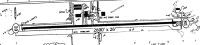
Maps & Diagrams
42I Sectional
Flight Planning
at skyvector.com
at skyvector.com