Location
Latitude: |
40-01-28.8000N (40.024667) |
Longitude: |
082-27-42.5000W (-82.461806) |
Elevation: |
883.8 feet MSL (269 m MSL) |
Magnetic Variation: |
7.6 W (as of April 2024 from WMM2020 model) |
Time Zone: |
UTC -5.0 (Standard Time) UTC -4.0 (Daylight Savings Time) |
From City: |
03 N.M. SW of Newark, Ohio |
Found On: |
Detroit Chart |
FAA Region: |
AGL |
Contacts
Manager: |
Publicly owned: |
| HAROLD WARE 530 HEATH RD HEATH, OH 43056-1134 740-522-6968 |
LICKING CO RGNL ARPT AUTH 530 HEATH RD HEATH, OH 43056-1134 740-522-6968 |
Operations
Airport Status: |
Operational |
Facility Use: |
Public |
Type: |
Airport |
Activation Date: |
12/1937 |
Control tower: |
No |
Attendance (Months/Days/Hours): |
Months/Days/Hours APR-OCT/ALL/0730-1930 |
Boundary ARTCC: |
ZID (Indianapolis) |
Responsible ARTCC: |
ZID (Indianapolis) |
Lighting Schedule: |
SEE RMK |
Segmented Circle Indicator: |
No |
Traffic Pattern Altitude (MSL): |
1884 feet (574 m) |
NOTAMs Facility: |
VTA |
NOTAM-D Service: |
Yes |
International Airport of Entry: |
No |
Customs Landing Rights: |
No |
Military Landing Rights: |
No |
Civil/Military Joint Use: |
No |
Based Aircraft
| Single Engine: | 63 |
| Multi Engine: | 6 |
| Jet Engine: | 1 |
Annual Operations (as of 12/21/2022)
| Total Operations: | 9210 | |
| Air Taxi: | 80 | 0.9% |
| GA Local: | 4552 | 49.4% |
| GA Itinerant: | 4478 | 48.6% |
| Military Aircraft: | 100 | 1.1% |
Communications
| CTAF: | 122.700 |
| Unicom: | 122.700 |
| Clearance Del.: | 125.175 125.175 125.175 |
| Approach: | COLUMBUS |
| Departure: | COLUMBUS |
| ASOS: | 121.125 (740-522-1066) |
Fixed Based Operators (FBOs) & Fuel
(Click on a business for detail)
Please help us keep this information up to date. This is a FREE SERVICE just like everything else on Airport Guide! If you see that a business needs to be added, modified, or deleted please fill out our Update Form.
To add, modify, or delete a business click here.
Please help us keep this information up to date. This is a FREE SERVICE just like everything else on Airport Guide! If you see that a business needs to be added, modified, or deleted please fill out our Update Form.
Area Code: 740 |
| Business Name | Frequency | Phone | Fuel Grade |
|---|---|---|---|
| The Aviation Works, Inc.
Update FBO info |
Unicom 122.7 | 522-6968 | 80, 100LL, Jet A |
Flight Service Stations
| Primary | Alternate | |
| FSS on Field: | N | |
| FSS Name (ID): | Dayton(DAY) | |
| Frequency: | ||
| Toll Free Phone: | 1-800-WX-BRIEF |
Instrument Procedures / Charts
FAA Terminal Procedures valid from 0901Z 03/21/24 to 0901Z 04/18/24.
There are various types of charts available for an airport. They are listed in the Page Type column. Here is a legend for those types:
APD - Airport Diagram
DP - Departure Procedure Charts
HOT - Hot Spots
IAP - Instrument Approach Procedure Charts
MIN - Minimums
STAR - Standard Terminal Arrival Charts
| Page Type | Page Name | Volume | Action Since Last Cycle |
|---|---|---|---|
| IAP | LOC RWY 09 | EC-2 | |
| IAP | RNAV (GPS) RWY 09 | EC-2 | |
| IAP | RNAV (GPS) RWY 27 | EC-2 | |
| IAP | VOR-A | EC-2 | |
| MIN | ALTERNATE MINIMUMS | EC-2 | |
| MIN | TAKEOFF MINIMUMS | EC-2 |
Terminal Procedures are only available for airports in several countries with more being added all the time. If you are looking for a specific country's charts, please send an email to support(at)airportguide.com stating the country name. This will be used to prioritize the implementation.
Navigation Aids (Navaids) near KVTA
| Dist (NM) | ID | Morse Code | Name | Type | Freq | True Hdg | Mag Hdg |
|---|---|---|---|---|---|---|---|
| 0.1 | HEH | . . . . . . . . . | Newark | NDB | 524 | 313 | 321 |
| 9.6 | APE | . _ . _ _ . . | Appleton | VORTAC | 116.70 | 322 | 330 |
| 13.6 | CM | _ . _ . _ _ | Sumie | NDB | 391 | 260 | 268 |
| 19.2 | LC | . _ . . _ . _ . | Pickl | NDB | 376 | 243 | 250 |
| 19.5 | CMH | _ . _ . _ _ . . . . | Port Columbus | VOT | 111.00 | 264 | 271 |
| 25.1 | LCK | . _ . . _ . _ . _ . _ | Rickenbacker | TACAN | 69X | 239 | 246 |
| 25.9 | HRA | . . . . . _ . . _ | Zanesville | NDB | 204 | 105 | 113 |
| 26.1 | CHC | _ . _ . . . . . _ . _ . | Grens | NDB | 272 | 268 | 275 |
| 26.6 | ZZV | _ _ . . _ _ . . . . . _ | Zanesville | VOR-DME | 114.95 | 100 | 108 |
| 30.8 | DD | _ . . _ . . | Cobbs | NDB | 253 | 236 | 243 |
| 33.9 | OS | _ _ _ . . . | Fuler | NDB | 515 | 275 | 282 |
| 36.3 | BU | _ . . . . . _ | Boutn | NDB | 230 | 250 | 257 |
| 38.2 | XUB | _ . . _ . . _ _ . . . | Yellow Bud | VOR | 112.50 | 218 | 225 |
| 41.1 | MLR | _ _ . _ . . . _ . | Millersburg/Dcmsnd | NDB | 382 | 40 | 48 |
| 43.8 | RZT | . _ . _ _ . . _ | Ross County | NDB | 236 | 216 | 223 |
| 44.5 | MF | _ _ . . _ . | Manns | NDB | 372 | 0 | 8 |
| 44.9 | BUD | _ . . . . . _ _ . . | Buckeye | VOR | 109.80 | 322 | 329 |
| 46.8 | CTW | _ . _ . _ . _ _ | Newcomerstown | DME | 111.8 | 74 | 82 |
| 48.6 | UGS | . . _ _ _ . . . . | University | NDB | 250 | 161 | 169 |
| 49.5 | UNI | . . _ _ . . . | Athens | FAN MARKER | 165 | 173 |
Nearby Airports with Fuel
Notices to Airmen (NOTAMS)
Remarks
| A110-3 | OCNL DEER, BIRDS, & OTR WILDLIFE ON & INVOF ARPT. |
| A16 | ADNL CTC: 740-929-4205 OR AVIATIONWORKSINC@GMAIL.COM |
| A48-09 | U/S INDEFLY. |
| A48-27 | U/S INDEFLY. |
| A57-09 | APCH RATIO 18:1 OVR +15 FT ROAD, 279 FT DIST, 266 FT R. |
| A58-09 | +15 FT ROAD, 0 FT DIST, 200 FT R; +11 FT FENCE, 0-200 FT DIST, 129-198 FT R. |
| A58-27 | +3-5 FT BERM, 0-200 FT DIST, 155 FT L/R. |
| A70-FUEL-10 | 0LL 100LL AVBL 24/7 WITH CREDIT CARD. |
| A81-APT | INCR INTST REIL RWY 09 & 27; MIRL RWY 09/27 - 123.3. LGTS PRESET LOW INTST. |
Runways
Runway Summary
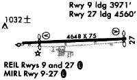
| Runways: | 09/27 |
| Longest Runway: | 09/27 is 4649 ft (1417 m) long |
| Runways with an Instrument Approach: | 09 |
KVTA Airport Runway Details
| Runway 09/27 | 4649 ft x 75 ft (1417 m x 23 m) | |
| Runway Length Source: | 3RD PARTY SURVEY as of 01/21/2011 | |
| Surface: | Asphalt - Good condition - No special surface treatment | |
| Runway Edge Lights: | Medium Intensity | |
Runway Weight Bearing Capacity (in thousands of pounds) |
||
| Single Wheel Landing Gear: | 30.0 | |
Runway 09 |
Runway 27 |
|
Elevation: |
882.4 | 869.8 |
Latitude: |
40-01-27.5489N | 40-01-29.9900N |
Longitude: |
082-28-12.3657W | 082-27-12.6988W |
|
Runway True Alignment: |
087 | 267 |
ILS Type: |
LOCALIZER | |
Glide Path Angle: |
3.2 degrees | 3.2 degrees |
Traffic Pattern: |
Left | Left |
Runway Markings Type: |
Nonprecision Instrument | Nonprecision Instrument |
Runway Markings Condition: |
Good | Good |
Object at End: |
ROAD | BERM |
Object Height: |
15 | 4 |
Distance from End: |
201 | 201 |
Object Centerline Offset: |
220 ft. right of centerline | 155 ft. left and right of centerline |
Visual Glide Slope Indicators: |
4-Light PAPI On Left Side Of Runway | 4-Light PAPI On Right Side Of Runway |
REIL: |
Yes | Yes |
Touchdown Lights: |
No | No |
Centerline Lights: |
No | No |
Threshold Crossing Height: |
28 | 20 |
Threshold Elevation: |
883.4 | |
Displaced Threshold: |
457 | |
Threshold Latitude: |
40-01-27.7894N | |
Threshold Longitude: |
082-28-06.4989W |
Services
Airframe Repair: |
Major |
Powerplant Repair: |
Major |
Bottled Oxygen: |
None |
Bulk Oxygen: |
None |
Fuel Available: |
100LL, Jet A |
Landing Fees: |
No |
Parking: |
Hangars and tiedowns available |
Maps & Diagrams
KVTA Sectional
Flight Planning
at skyvector.com
at skyvector.com