Location
Latitude: |
39-56-40.0060N (39.944446) |
Longitude: |
081-53-31.5390W (-81.892094) |
Elevation: |
899.8 feet MSL (274 m MSL) |
Magnetic Variation: |
8 W (as of April 2024 from WMM2020 model) |
Time Zone: |
UTC -5.0 (Standard Time) UTC -4.0 (Daylight Savings Time) |
From City: |
05 N.M. E of Zanesville, Ohio |
Found On: |
Cincinnati Chart |
FAA Region: |
AGL |
Contacts
Manager: |
Publicly owned: |
| JIM WITTE 850 AIRPORT RD ZANESVILLE, OH 43701-0969 740-452-3625 |
CITY OF ZANESVILLE 401 MARKET ST ZANESVILLE, OH 43701-3520 740-455-0663 |
Operations
Airport Status: |
Operational |
Facility Use: |
Public |
Type: |
Airport |
Activation Date: |
11/1944 |
Control tower: |
No |
Attendance (Months/Days/Hours): |
Months/Days/Hours ALL/MON-FRI/0800-1800 |
Boundary ARTCC: |
ZID (Indianapolis) |
Responsible ARTCC: |
ZID (Indianapolis) |
Lighting Schedule: |
SEE RMK |
Segmented Circle Indicator: |
No |
Traffic Pattern Altitude (MSL): |
1900 feet (579 m) |
NOTAMs Facility: |
ZZV |
NOTAM-D Service: |
Yes |
International Airport of Entry: |
No |
Customs Landing Rights: |
No |
Military Landing Rights: |
Yes |
Civil/Military Joint Use: |
No |
Based Aircraft
| Single Engine: | 15 |
| Multi Engine: | 5 |
| Jet Engine: | 6 |
Annual Operations (as of 06/12/2020)
| Total Operations: | 33312 | |
| Air Taxi: | 1064 | 3.2% |
| GA Local: | 25000 | 75.0% |
| GA Itinerant: | 6800 | 20.4% |
| Military Aircraft: | 448 | 1.3% |
Communications
| CTAF: | 123.000 |
| Unicom: | 123.000 |
| ASOS: | 114.95 (740-453-8139) |
- APCH/DEP SVC PRVDD BY INDIANAPOLIS ARTCC ON FREQS 124.45/323.275 (ZANESVILLE RCAG).
Fixed Based Operators (FBOs) & Fuel
(Click on a business for detail)
Please help us keep this information up to date. This is a FREE SERVICE just like everything else on Airport Guide! If you see that a business needs to be added, modified, or deleted please fill out our Update Form.
To add, modify, or delete a business click here.
Please help us keep this information up to date. This is a FREE SERVICE just like everything else on Airport Guide! If you see that a business needs to be added, modified, or deleted please fill out our Update Form.
Area Code: 740 |
| Business Name | Frequency | Phone | Fuel Grade |
|---|---|---|---|
| Southeastern Ohio Air Service, Inc.
Update FBO info |
Unicom 123.0 | 452-3625 | 80, 100LL, Jet A |
Flight Service Stations
| Primary | Alternate | |
| FSS on Field: | N | |
| FSS Name (ID): | Cleveland(CLE) | |
| Frequency: | ||
| Toll Free Phone: | 1-800-WX-BRIEF |
Instrument Procedures / Charts
FAA Terminal Procedures valid from 0901Z 03/21/24 to 0901Z 04/18/24.
There are various types of charts available for an airport. They are listed in the Page Type column. Here is a legend for those types:
APD - Airport Diagram
DP - Departure Procedure Charts
HOT - Hot Spots
IAP - Instrument Approach Procedure Charts
MIN - Minimums
STAR - Standard Terminal Arrival Charts
| Page Type | Page Name | Volume | Action Since Last Cycle |
|---|---|---|---|
| IAP | ILS OR LOC RWY 22 | EC-2 | |
| IAP | RNAV (GPS) RWY 04 | EC-2 | |
| IAP | RNAV (GPS) RWY 22 | EC-2 | |
| IAP | VOR RWY 04 | EC-2 | Deleted |
| IAP | VOR RWY 22 | EC-2 | Deleted |
| MIN | ALTERNATE MINIMUMS | EC-2 | Changed |
| MIN | TAKEOFF MINIMUMS | EC-2 |
Terminal Procedures are only available for airports in several countries with more being added all the time. If you are looking for a specific country's charts, please send an email to support(at)airportguide.com stating the country name. This will be used to prioritize the implementation.
Navigation Aids (Navaids) near ZZV
| Dist (NM) | ID | Morse Code | Name | Type | Freq | True Hdg | Mag Hdg |
|---|---|---|---|---|---|---|---|
| 0.2 | ZZV | _ _ . . _ _ . . . . . _ | Zanesville | VOR-DME | 114.95 | 186 | 194 |
| 2.6 | HRA | . . . . . _ . . _ | Zanesville | NDB | 204 | 208 | 216 |
| 25.6 | CTW | _ . _ . _ . _ _ | Newcomerstown | DME | 111.8 | 48 | 56 |
| 26.7 | HEH | . . . . . . . . . | Newark | NDB | 524 | 280 | 288 |
| 34.3 | APE | . _ . _ _ . . | Appleton | VORTAC | 116.70 | 291 | 299 |
| 35.8 | MLR | _ _ . _ . . . _ . | Millersburg/Dcmsnd | NDB | 382 | 1 | 9 |
| 38.5 | JPU | . _ _ _ . _ _ . . . _ | Parkersburg | VOR-DME | 114.45 | 141 | 149 |
| 39.7 | CM | _ . _ . _ _ | Sumie | NDB | 391 | 273 | 281 |
| 40.2 | PKB | . _ _ . _ . _ _ . . . | Marietta Ohio | FAN MARKER | 146 | 154 | |
| 42.6 | UGS | . . _ _ _ . . . . | University | NDB | 250 | 194 | 202 |
| 43.6 | LC | . _ . . _ . _ . | Pickl | NDB | 376 | 265 | 273 |
| 44.0 | CFX | _ . _ . . . _ . _ . . _ | Cadiz | NDB | 239 | 66 | 74 |
| 45.3 | UNI | . . _ _ . . . | Athens | FAN MARKER | 198 | 206 | |
| 45.5 | PK | . _ _ . _ . _ | Versi | NDB | 388 | 155 | 163 |
| 45.8 | CMH | _ . _ . _ _ . . . . | Port Columbus | VOT | 111.00 | 274 | 282 |
| 48.4 | LCK | . _ . . _ . _ . _ . _ | Rickenbacker | TACAN | 69X | 260 | 268 |
| 49.6 | AIR | . _ . . . _ . | Bellaire | VOR-DME | 117.10 | 84 | 92 |
| 52.2 | BSV | _ . . . . . . . . . _ | Briggs | VOR-DME | 112.40 | 23 | 31 |
| 52.4 | CHC | _ . _ . . . . . _ . _ . | Grens | NDB | 272 | 274 | 282 |
| 53.4 | DD | _ . . _ . . | Cobbs | NDB | 253 | 257 | 265 |
Nearby Airports with Fuel
Notices to Airmen (NOTAMS)
Remarks
| A110-1 | DEER, BIRDS, & OTR WILDLIFE ON & INVOF ARPT. |
| A110-3 | RWY 04/22 & RWY 16/34 ACFT NOT VSB FM RWY ENDS. |
| A110-4 | TWY B LGTS U/S INDEFLY. |
| A110-5 | FOR CD IF UNA TO CTC ON FSS FREQ, CTC INDIANAPOLIS ARTCC AT 317-247-2411. |
| A14 | JIM.WITTE@COZ.ORG. |
| A42-04 | FADED. |
| A42-22 | FADED. |
| A43-04 | PAPI UNUSBL BYD 4 DEGS RIGHT OF CNTRLN. |
| A57-16 | OBST CLNC SLP 32:1 TO DTHR. |
| A57-34 | OBST CLNC SLP 30:1 TO DTHR. |
| A58-04 | +5 FT BRUSH, 0-95 FT DIST, 180-245 FT R. |
| A58-16 | +2-5 FT BRUSH, 125 FT DIST, 130 FT L/R. |
| A75 | PRIOR CDN RQRD. |
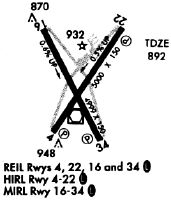
| A81-APT | ACTVT REIL RWY 04, 22, 16, & 34; HIRL RWY 04/22; MIRL RWY 16/34 - CTAF. PAPI RWY 04 & 22 OPR CONSLY. |
Runways
Runway Summary
| Runways: | 04/22 16/34 |
| Longest Runway: | 04/22 is 4999 ft (1524 m) long |
| Runways with an Instrument Approach: | 22 |
ZZV Airport Runway Details
| Runway 04/22 | 4999 ft x 150 ft (1524 m x 46 m) | |
| Runway Length Source: | 3RD PARTY SURVEY as of 11/20/2019 | |
| Surface: | Asphalt - Good condition - No special surface treatment | |
| Runway Edge Lights: | High Intensity | |
Runway Weight Bearing Capacity (in thousands of pounds) |
||
| Single Wheel Landing Gear: | 38.0 | |
| Dual Wheel Landing Gear: | 50.0 | |
| Dual Tandem Wheel Landing Gear: | 75.0 | |
Runway 04 |
Runway 22 |
|
Elevation: |
896.1 | 869.4 |
Latitude: |
39-56-20.5847N | 39-57-01.6223N |
Longitude: |
081-53-45.0628W | 081-53-09.3264W |
|
Runway True Alignment: |
034 | 214 |
ILS Type: |
ILS/DME | |
Glide Path Angle: |
3.0 degrees | 3.0 degrees |
Traffic Pattern: |
Left | Left |
Runway Markings Type: |
Nonprecision Instrument | Precision Instrument |
Runway Markings Condition: |
Poor | Poor |
Visual Glide Slope Indicators: |
4-Light PAPI On Right Side Of Runway | 4-Light PAPI On Left Side Of Runway |
REIL: |
Yes | Yes |
Touchdown Lights: |
No | No |
Centerline Lights: |
No | No |
Threshold Crossing Height: |
35 | 47 |
| Runway 16/34 | 4998 ft x 75 ft (1523 m x 23 m) | |
| Runway Length Source: | 3RD PARTY SURVEY as of 11/20/2019 | |
| Surface: | Asphalt - Good condition - Aggregate friction seal coat | |
| Runway Edge Lights: | Medium Intensity | |
Runway Weight Bearing Capacity (in thousands of pounds) |
||
| Single Wheel Landing Gear: | 38.0 | |
| Dual Wheel Landing Gear: | 50.0 | |
| Dual Tandem Wheel Landing Gear: | 75.0 | |
Runway 16 |
Runway 34 |
|
Elevation: |
866.7 | 895.4 |
Latitude: |
39-57-00.8084N | 39-56-17.0065N |
Longitude: |
081-53-50.7109W | 081-53-21.0571W |
|
Runway True Alignment: |
152 | 332 |
Glide Path Angle: |
0.0 degrees | 0.0 degrees |
Traffic Pattern: |
Left | Left |
Runway Markings Type: |
Nonprecision Instrument | Nonprecision Instrument |
Runway Markings Condition: |
Good | Good |
Object at End: |
TREES | TREES |
Object Height: |
35 | 15 |
Distance from End: |
850 | 290 |
Visual Glide Slope Indicators: |
4-Light PAPI On Left Side Of Runway | |
REIL: |
Yes | Yes |
Touchdown Lights: |
No | No |
Centerline Lights: |
No | No |
Threshold Elevation: |
868.6 | 895.9 |
Displaced Threshold: |
200 | 200 |
Threshold Latitude: |
39-56-59.0598N | 39-56-18.7600N |
Threshold Longitude: |
081-53-49.5250W | 081-53-22.2437W |
Declared Distances |
||
Take Off Run Avbl. (TORA): |
4998 | 4998 |
Take Off Distance Avbl. (TODA): |
4998 | 4998 |
Actual Stop Dist. Avbl. (ASDA): |
4798 | 4798 |
Landing Dist. Avbl. (LDA): |
4598 | 4598 |
Services
Airframe Repair: |
Major |
Powerplant Repair: |
Major |
Bottled Oxygen: |
None |
Bulk Oxygen: |
None |
Fuel Available: |
100LL |
Landing Fees: |
No |
Parking: |
Hangars and tiedowns available |
Maps & Diagrams
ZZV Sectional
Flight Planning
at skyvector.com
at skyvector.com