Location
Latitude: |
40-36-58.5000N (40.61625) |
Longitude: |
083-03-48.5000W (-83.063472) |
Elevation: |
993.4 feet MSL (303 m MSL) |
Magnetic Variation: |
7.3 W (as of April 2024 from WMM2020 model) |
Time Zone: |
UTC -5.0 (Standard Time) UTC -4.0 (Daylight Savings Time) |
From City: |
03 N.M. NE of Marion, Ohio |
Found On: |
Detroit Chart |
FAA Region: |
AGL |
Contacts
Manager: |
Publicly owned: |
| MATTHEW 'MATT' ARNOLD 1530 POLE LANE RD MARION, OH 43302-8514 740-382-1634 |
CITY OF MARION CITY HALL, 233 W CENTER ST MARION, OH 43302-3692 740-387-2020 |
Operations
Airport Status: |
Operational |
Facility Use: |
Public |
Type: |
Airport |
Activation Date: |
09/1950 |
Control tower: |
No |
Attendance (Months/Days/Hours): |
Months/Days/Hours ALL/ALL/0800-1700 |
Boundary ARTCC: |
ZOB (Cleveland) |
Responsible ARTCC: |
ZOB (Cleveland) |
Lighting Schedule: |
SEE RMK |
Segmented Circle Indicator: |
No |
Traffic Pattern Altitude (MSL): |
1993 feet (607 m) |
NOTAMs Facility: |
MNN |
NOTAM-D Service: |
Yes |
International Airport of Entry: |
No |
Customs Landing Rights: |
No |
Military Landing Rights: |
Yes |
Civil/Military Joint Use: |
No |
Based Aircraft
| Single Engine: | 18 |
| Multi Engine: | 3 |
| Gliders: | 27 |
Annual Operations (as of 09/17/2020)
| Total Operations: | 35650 | |
| Air Taxi: | 500 | 1.4% |
| GA Local: | 20000 | 56.1% |
| GA Itinerant: | 15000 | 42.1% |
| Military Aircraft: | 150 | 0.4% |
Communications
| CTAF: | 122.800 |
| Unicom: | 122.800 |
| Approach: | CLEVELAND 124.2 124.2 124.2 CLEVELAND ARTCC |
| Departure: | CLEVELAND 124.2 124.2 124.2 CLEVELAND ARTCC |
| ASOS: | 119.975 (740-223-7502) |
- APCH/DEP SVC PRVDD BY CLEVELAND APCH (CLE) 0600-0100. APCH/DEP SVC PRVDD BY CLEVELAND ARTCC (ZOB) ON FREQS 135.1/291.725 (FINDLAY RCAG) 0100-0600.
Fixed Based Operators (FBOs) & Fuel
(Click on a business for detail)
Please help us keep this information up to date. This is a FREE SERVICE just like everything else on Airport Guide! If you see that a business needs to be added, modified, or deleted please fill out our Update Form.
To add, modify, or delete a business click here.
Please help us keep this information up to date. This is a FREE SERVICE just like everything else on Airport Guide! If you see that a business needs to be added, modified, or deleted please fill out our Update Form.
Area Code: 614 |
| Business Name | Frequency | Phone | Fuel Grade |
|---|---|---|---|
| Aerospec
Update FBO info |
Unicom 122.8 | 387-1933 | 100LL, Jet A |
| Baron Enterprises
Update FBO info |
Unicom 123.3 | 383-4914 | 80, 100LL, Jet A |
Flight Service Stations
| Primary | Alternate | |
| FSS on Field: | N | |
| FSS Name (ID): | Cleveland(CLE) | |
| Frequency: | ||
| Toll Free Phone: | 1-800-WX-BRIEF |
Instrument Procedures / Charts
FAA Terminal Procedures valid from 0901Z 03/21/24 to 0901Z 04/18/24.
There are various types of charts available for an airport. They are listed in the Page Type column. Here is a legend for those types:
APD - Airport Diagram
DP - Departure Procedure Charts
HOT - Hot Spots
IAP - Instrument Approach Procedure Charts
MIN - Minimums
STAR - Standard Terminal Arrival Charts
| Page Type | Page Name | Volume | Action Since Last Cycle |
|---|---|---|---|
| IAP | RNAV (GPS) RWY 07 | EC-2 | |
| IAP | RNAV (GPS) RWY 13 | EC-2 | |
| IAP | RNAV (GPS) RWY 25 | EC-2 | |
| IAP | VOR-A | EC-2 | |
| MIN | ALTERNATE MINIMUMS | EC-2 | |
| MIN | TAKEOFF MINIMUMS | EC-2 |
Terminal Procedures are only available for airports in several countries with more being added all the time. If you are looking for a specific country's charts, please send an email to support(at)airportguide.com stating the country name. This will be used to prioritize the implementation.
Navigation Aids (Navaids) near MNN
| Dist (NM) | ID | Morse Code | Name | Type | Freq | True Hdg | Mag Hdg |
|---|---|---|---|---|---|---|---|
| 0.0 | BUD | _ . . . . . _ _ . . | Buckeye | VOR | 109.80 | 324 | 331 |
| 26.3 | MFD | _ _ . . _ . _ . . | Mansfield | VORTAC | 108.80 | 54 | 61 |
| 29.1 | RUV | . _ . . . _ . . . _ | Rushsylvania | NDB | 326 | 251 | 258 |
| 29.5 | TII | _ . . . . | Tiffin | NDB | 269 | 346 | 353 |
| 29.5 | MF | _ _ . . _ . | Manns | NDB | 372 | 72 | 80 |
| 33.1 | OS | _ _ _ . . . | Fuler | NDB | 515 | 190 | 197 |
| 35.4 | APE | . _ . _ _ . . | Appleton | VORTAC | 116.70 | 141 | 148 |
| 36.4 | CHC | _ . _ . . . . . _ . _ . | Grens | NDB | 272 | 177 | 184 |
| 36.7 | BNR | _ . . . _ . . _ . | Benton Ridge | NDB | 334 | 311 | 318 |
| 37.5 | FBC | . . _ . _ . . . _ . _ . | Flag City | VORTAC | 108.20 | 303 | 310 |
| 37.6 | FZI | . . _ . _ _ . . . . | Fostoria | NDB | 379 | 336 | 343 |
| 38.2 | CMH | _ . _ . _ _ . . . . | Port Columbus | VOT | 111.00 | 167 | 174 |
| 40.4 | CM | _ . _ . _ _ | Sumie | NDB | 391 | 159 | 166 |
| 41.5 | AOH | . _ _ _ _ . . . . | Allen County | VOR | 108.40 | 277 | 284 |
| 42.3 | AAU | . _ . _ . . _ | Ashland | NDB | 329 | 60 | 68 |
| 44.8 | HEH | . . . . . . . . . | Newark | NDB | 524 | 142 | 149 |
| 45.3 | LC | . _ . . _ . _ . | Pickl | NDB | 376 | 166 | 173 |
| 48.3 | BU | _ . . . . . _ | Boutn | NDB | 230 | 187 | 194 |
| 48.9 | LCK | . _ . . _ . _ . _ . _ | Rickenbacker | TACAN | 69X | 172 | 179 |
| 48.9 | ROD | . _ . _ _ _ _ . . | Rosewood | VORTAC | 117.50 | 246 | 253 |
Nearby Airports with Fuel
Notices to Airmen (NOTAMS)
Remarks
| A110-1 | GLIDER ACT ON & INVOF ARPT, ANNC INTNS - CTAF. |
| A110-3 | TSNT ACFT FOLLOW RAMP SIGNS TO MAIN RAMP. TWY D BTN RWY & RAMP AREA RSTRD TO ACFT WITH WINGSPAN 35 FT OR LESS. |
| A110-5 | FOR CD CTC CLEVELAND APCH AT 216-352-2323, WHEN APCH CLSD CTC CLEVELAND ARTCC AT 440-774-0222. |
| A110-6 | OCNL DEER, BIRDS, & OTR WILDLIFE ON & INVOF ARPT. |
| A16 | ARPT OPS MGR 740-725-4146. ARPT DIR FOR EMERG ONLY 740-341-2233. |
| A23-07 | GLIDERS & TOWPLANES USE RIGHT TFC. |
| A23-31 | GLIDERS & TOWPLANES USE RIGHT TFC. |
| A70-FUEL-10 | 0LL 100LL AVBL H24 SELF SER VIA CREDIT CARD. JET A AVBL AFT HRS BY PRIOR CDN. |
| A75 | PRIOR CDN RQRD. |
| A81-APT | ACTVT REIL RWY 07, 25, 13, & 31; MIRL RWY 07/25 & 13/31 - CTAF. PAPI RWY 07, 25, 13, & 31 OPR CONSLY. |
| E111 | ESTABD BFR 1959. |
Runways
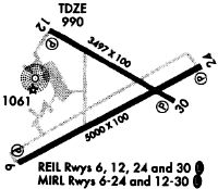
Runway Summary
| Runways: | 07/25 13/31 |
| Longest Runway: | 07/25 is 5000 ft (1524 m) long |
| Runways with an Instrument Approach: | 25 |
MNN Airport Runway Details
| Runway 07/25 | 5000 ft x 100 ft (1524 m x 30 m) | |
| Runway Length Source: | 3RD PARTY SURVEY as of 01/27/2011 | |
| Surface: | Asphalt - Fair condition - Saw-cut or plastic grooved | |
| Runway Edge Lights: | Medium Intensity | |
Runway Weight Bearing Capacity (in thousands of pounds) |
||
| Single Wheel Landing Gear: | 70.0 | |
| Dual Wheel Landing Gear: | 95.0 | |
| Dual Tandem Wheel Landing Gear: | 150.0 | |
Runway 07 |
Runway 25 |
|
Elevation: |
989.4 | 993.4 |
Latitude: |
40-36-41.1129N | 40-37-05.8573N |
Longitude: |
083-04-16.7952W | 083-03-20.6808W |
|
Runway True Alignment: |
060 | 240 |
ILS Type: |
LOC/DME | |
Glide Path Angle: |
3.0 degrees | 3.0 degrees |
Traffic Pattern: |
Left | Left |
Runway Markings Type: |
Nonprecision Instrument | Nonprecision Instrument |
Runway Markings Condition: |
Good | Good |
Object at End: |
ROAD | TREES |
Object Height: |
15 | 75 |
Distance from End: |
475 | 3050 |
Object Centerline Offset: |
280 ft. left of centerline | 155 ft. right of centerline |
Visual Glide Slope Indicators: |
4-Light PAPI On Left Side Of Runway | 4-Light PAPI On Left Side Of Runway |
REIL: |
Yes | Yes |
Touchdown Lights: |
No | No |
Centerline Lights: |
No | No |
Threshold Crossing Height: |
24 | 31 |
| Runway 13/31 | 3498 ft x 100 ft (1066 m x 30 m) | |
| Runway Length Source: | 3RD PARTY SURVEY as of 01/27/2011 | |
| Surface: | Asphalt - Fair condition - Saw-cut or plastic grooved | |
| Runway Edge Lights: | Medium Intensity | |
Runway Weight Bearing Capacity (in thousands of pounds) |
||
| Single Wheel Landing Gear: | 56.0 | |
| Dual Wheel Landing Gear: | 68.0 | |
| Dual Tandem Wheel Landing Gear: | 105.0 | |
Runway 13 |
Runway 31 |
|
Elevation: |
986.2 | 989.4 |
Latitude: |
40-37-14.3945N | 40-36-57.1436N |
Longitude: |
083-04-07.8539W | 083-03-28.5570W |
|
Runway True Alignment: |
120 | 300 |
Glide Path Angle: |
3.0 degrees | 3.0 degrees |
Traffic Pattern: |
Left | Left |
Runway Markings Type: |
Nonprecision Instrument | Nonprecision Instrument |
Runway Markings Condition: |
Good | Good |
Object at End: |
TREES | PLINE |
Object Height: |
45 | 45 |
Distance from End: |
1345 | 1875 |
Object Centerline Offset: |
280 ft. left of centerline | 155 ft. right of centerline |
Visual Glide Slope Indicators: |
2-Light PAPI On Right Side Of Runway | 2-Light PAPI On Left Side Of Runway |
REIL: |
Yes | Yes |
Touchdown Lights: |
No | No |
Centerline Lights: |
No | No |
Threshold Crossing Height: |
21 | 21 |
Services
Airframe Repair: |
Major |
Powerplant Repair: |
Major |
Bottled Oxygen: |
None |
Bulk Oxygen: |
High Pressure / Low Pressure |
Fuel Available: |
100LL, Jet A-1, Jet A-1+ |
Landing Fees: |
No |
Parking: |
Hangars available |
Maps & Diagrams
MNN Sectional
Flight Planning
at skyvector.com
at skyvector.com