Location
Latitude: |
39-28-01.2660N (39.467018) |
Longitude: |
077-01-02.7550W (-77.017432) |
Elevation: |
798.6 feet MSL (243 m MSL) |
Magnetic Variation: |
10.9 W (as of April 2024 from WMM2020 model) |
Time Zone: |
UTC -5.0 (Standard Time) UTC -4.0 (Daylight Savings Time) |
From City: |
07 N.M. S of Westminster, Maryland |
Found On: |
Washington Chart |
FAA Region: |
AEA |
Contacts
Manager: |
Privately owned: |
| THOMAS CHAPMAN 526 OAK TREE ROAD WESTMINSTER, MD 21157 410-795-1176 |
CLEARVIEW AIRPORT INC 526 OAK TREE ROAD WESTMINSTER, MD 21157 410-795-1176 |
Operations
Airport Status: |
Operational |
Facility Use: |
Public |
Type: |
Airport |
Activation Date: |
07/1966 |
Control tower: |
No |
Attendance (Months/Days/Hours): |
Months/Days/Hours ALL/ALL/0900-1700 |
Boundary ARTCC: |
ZNY (New York) |
Responsible ARTCC: |
ZDC (Washington) |
Lighting Schedule: |
SEE RMK |
Segmented Circle Indicator: |
No |
Traffic Pattern Altitude (MSL): |
1799 feet (548 m) |
NOTAMs Facility: |
DCA |
NOTAM-D Service: |
Yes |
Based Aircraft
| Single Engine: | 24 |
Annual Operations (as of 04/29/2023)
| Total Operations: | 8050 | |
| GA Local: | 7150 | 88.8% |
| GA Itinerant: | 900 | 11.2% |
Communications
| CTAF: | 122.800 |
| Unicom: | 122.800 |
| Approach: | POTOMAC 125.525 125.525 |
| Departure: | POTOMAC 125.525 125.525 |
Fixed Based Operators (FBOs) & Fuel
(Click on a business for detail)
Please help us keep this information up to date. This is a FREE SERVICE just like everything else on Airport Guide! If you see that a business needs to be added, modified, or deleted please fill out our Update Form.
To add, modify, or delete a business click here.
Please help us keep this information up to date. This is a FREE SERVICE just like everything else on Airport Guide! If you see that a business needs to be added, modified, or deleted please fill out our Update Form.
Area Code: 410 |
| Business Name | Frequency | Phone | Fuel Grade |
|---|---|---|---|
| Clearview Airport, Inc.
Update FBO info |
Unicom 122.8 | 795-9840, -1176 | 80, 100LL |
| Jim's Aviation
Update FBO info |
751-6033 |
Flight Service Stations
| Primary | Alternate | |
| FSS on Field: | N | |
| FSS Name (ID): | Leesburg(DCA) | |
| Frequency: | ||
| Toll Free Phone: | 1-800-WX-BRIEF |
Instrument Procedures / Charts
FAA Terminal Procedures valid from 0901Z 03/21/24 to 0901Z 04/18/24.
There are various types of charts available for an airport. They are listed in the Page Type column. Here is a legend for those types:
APD - Airport Diagram
DP - Departure Procedure Charts
HOT - Hot Spots
IAP - Instrument Approach Procedure Charts
MIN - Minimums
STAR - Standard Terminal Arrival Charts
| Page Type | Page Name | Volume | Action Since Last Cycle |
|---|---|---|---|
| IAP | RNAV (GPS) RWY 14 | NE-3 | Changed |
| IAP | VOR-A | NE-3 | Changed |
| MIN | TAKEOFF MINIMUMS | NE-3 |
Terminal Procedures are only available for airports in several countries with more being added all the time. If you are looking for a specific country's charts, please send an email to support(at)airportguide.com stating the country name. This will be used to prioritize the implementation.
Navigation Aids (Navaids) near 2W2
| Dist (NM) | ID | Morse Code | Name | Type | Freq | True Hdg | Mag Hdg |
|---|---|---|---|---|---|---|---|
| 2.5 | EMI | . _ _ . . | Westminster | VORTAC | 117.90 | 46 | 57 |
| 15.5 | FND | . . _ . _ . _ . . | Ellicott | NDB | 371 | 133 | 144 |
| 16.9 | FDK | . . _ . _ . . _ . _ | Frederick | VOR | 109.00 | 258 | 269 |
| 19.1 | GAI | _ _ . . _ . . | Gaithersburg | NDB | 385 | 201 | 212 |
| 21.2 | IUB | . . . . _ _ . . . | Institute | NDB | 404 | 120 | 131 |
| 24.3 | BAL | _ . . . . _ . _ . . | Baltimore | VORTAC | 115.10 | 136 | 147 |
| 25.9 | BUH | _ . . . . . _ . . . . | Anne Arundel | NDB | 260 | 152 | 163 |
| 27.9 | EUD | . . . _ _ . . | York | NDB | 254 | 13 | 24 |
| 32.6 | GTN | _ _ . _ _ . | Georgetown | NDB | 323 | 188 | 199 |
| 36.5 | DCA | _ . . _ . _ . . _ | Washington | VOR-DME | 111.00 | 181 | 192 |
| 38.2 | AML | . _ _ _ . _ . . | Armel | VOR-DME | 113.50 | 213 | 224 |
| 38.8 | MRB | _ _ . _ . _ . . . | Martinsburg | VORTAC | 112.10 | 263 | 274 |
| 39.2 | PPM | . _ _ . . _ _ . _ _ | Phillips | VOR-DME | 108.40 | 89 | 100 |
| 40.2 | ADW | . _ _ . . . _ _ | Andrews | VORTAC | 113.10 | 169 | 180 |
| 40.2 | ADW | . _ _ . . . _ _ | Andrews Afb | VOT | 109.60 | 170 | 181 |
| 41.2 | HGR | . . . . _ _ . . _ . | Hagerstown | VOR | 109.80 | 289 | 300 |
| 42.1 | DCA | _ . . _ . _ . . _ | Oxonn | NDB | 332 | 180 | 191 |
| 42.4 | APG | . _ . _ _ . _ _ . | Aberdeen | NDB | 349 | 84 | 95 |
| 42.7 | CX | _ . _ . _ . . _ | Latle | NDB | 219 | 0 | 11 |
| 45.4 | MDT | _ _ _ . . _ | Harrisburg | VOT | 110.00 | 14 | 25 |
Nearby Airports with Fuel
Notices to Airmen (NOTAMS)
Remarks
| A110-1 | 60 FT DROP OFF 125 FT FM AER 14. |
| A110-2 | ULTRALIGHT ACT ON & INVOF ARPT. |
| A110-4 | UNL VEHICLE ACES TO ACFT MOVEMENT AREAS. |
| A110-5 | FOR CD CTC POTOMAC APCH AT 866-429-5882. |
| A17 | ARPT UNATNDD THANKSGIVING, CHRISTMAS & NEW YEARS DAY. |
| A40-14/32 | NSTD - LGTS 20 FT FM RWY EDGE. |
| A57-32 | APCH RATIO 20:1 TO DSPLCD THR. |
| A58-14 | 40 FT TREES, 124 FT LEFT OF THLD. |
| A58-32 | 10 FT PVT ROAD AT THLD; 60 FT TREES, 140 FT RIGHT. |
| A81-APT | ACTVT LIRL RWY 14/32 - CTAF. |
| A81-BCN | ACTVT ROTG BCN - CTAF. |
Runways
Runway Summary
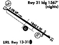
| Runways: | 14/32 |
| Longest Runway: | 14/32 is 1840 ft (561 m) long |
| Runways with an Instrument Approach: |
2W2 Airport Runway Details
| Runway 14/32 | 1840 ft x 30 ft (561 m x 9 m) | |
| Runway Length Source: | OWNER as of 11/30/2023 | |
| Surface: | Asphalt - Good condition - No special surface treatment | |
| Runway Edge Lights: | Low Intensity | |
Runway 14 |
Runway 32 |
|
Elevation: |
760.3 | 798.6 |
Latitude: |
39-28-06.4228N | 39-27-56.1083N |
Longitude: |
077-01-12.4099W | 077-00-53.1009W |
|
Runway True Alignment: |
125 | 305 |
Glide Path Angle: |
4.0 degrees | 7.0 degrees |
Traffic Pattern: |
Left | Left |
Runway Markings Type: |
Nonprecision Instrument | Nonprecision Instrument |
Runway Markings Condition: |
Good | Good |
Object at End: |
TREES | TREES |
Object Height: |
39 | 25 |
Distance from End: |
793 | 528 |
Object Centerline Offset: |
83 ft. left of centerline | 36 ft. left of centerline |
Visual Glide Slope Indicators: |
Approach Path Alignment Panels (APAP) On Left Side Of Runway | Approach Path Alignment Panels (APAP) On Left Side Of Runway |
Threshold Crossing Height: |
20 | 34 |
Threshold Elevation: |
786.5 | |
Displaced Threshold: |
277 | |
Threshold Latitude: |
39-27-57.6628N | |
Threshold Longitude: |
077-00-56.0108W |
Services
Airframe Repair: |
Major |
Powerplant Repair: |
None |
Bottled Oxygen: |
None |
Bulk Oxygen: |
None |
Fuel Available: |
100LL |
Landing Fees: |
No |
Parking: |
Tiedowns available |
Maps & Diagrams
2W2 Sectional
Flight Planning
at skyvector.com
at skyvector.com