Location
Latitude: |
39-10-06.0000N (39.168333) |
Longitude: |
077-09-57.6000W (-77.166) |
Elevation: |
538.7 feet MSL (164 m MSL) |
Magnetic Variation: |
10.7 W (as of April 2024 from WMM2020 model) |
Time Zone: |
UTC -5.0 (Standard Time) UTC -4.0 (Daylight Savings Time) |
From City: |
03 N.M. NE of Gaithersburg, Maryland |
Found On: |
Washington Chart |
FAA Region: |
AEA |
Contacts
Manager: |
Publicly owned: |
| JUSTIN BOLLUM, C.M. 7940 AIRPARK ROAD, SUITE 410 GAITHERSBURG, MD 20879 301-978-7009 |
MONTGOMERY COUNTY REV AUTH 101 MONROE ST 4TH FLOOR, SUITE 410 ROCKVILLE, MD 20850 301-762-9080 |
Operations
Airport Status: |
Operational |
Facility Use: |
Public |
Type: |
Airport |
Activation Date: |
08/1960 |
Control tower: |
No |
Attendance (Months/Days/Hours): |
Months/Days/Hours MARCH-MAY/ALL/0800-1900 |
Boundary ARTCC: |
ZDC (Washington) |
Responsible ARTCC: |
ZDC (Washington) |
Lighting Schedule: |
SEE RMK |
Segmented Circle Indicator: |
Yes |
Traffic Pattern Altitude (MSL): |
1539 feet (469 m) |
NOTAMs Facility: |
DCA |
NOTAM-D Service: |
Yes |
International Airport of Entry: |
No |
Customs Landing Rights: |
No |
Military Landing Rights: |
Yes |
Civil/Military Joint Use: |
No |
Based Aircraft
| Single Engine: | 128 |
| Multi Engine: | 15 |
| Jet Engine: | 11 |
| GA Helicopters: | 2 |
Annual Operations (as of 05/05/2023)
| Total Operations: | 67195 | |
| Air Taxi: | 1046 | 1.6% |
| GA Local: | 49578 | 73.8% |
| GA Itinerant: | 16526 | 24.6% |
| Military Aircraft: | 45 | 0.1% |
Communications
| CTAF: | 123.075 |
| Unicom: | 123.075 |
| Clearance Del.: | 121.6 121.6 121.6 121.6 121.6 121.6 121.6 |
| Approach: | POTOMAC |
| Departure: | POTOMAC |
| AWOS-3PT: | 128.275 (301-977-2971) |
Fixed Based Operators (FBOs) & Fuel
(Click on a business for detail)
Please help us keep this information up to date. This is a FREE SERVICE just like everything else on Airport Guide! If you see that a business needs to be added, modified, or deleted please fill out our Update Form.
To add, modify, or delete a business click here.
Please help us keep this information up to date. This is a FREE SERVICE just like everything else on Airport Guide! If you see that a business needs to be added, modified, or deleted please fill out our Update Form.
Area Code: 301 |
| Business Name | Frequency | Phone | Fuel Grade |
|---|---|---|---|
| Aerotronic Services, Inc.
Update FBO info |
948-2510 | ||
| Congressional Air Ltd.
Update FBO info |
840-0880 | ||
| Martin Air Charter
Update FBO info |
419-5400, 800-777-7401 | ||
| Montgomery Aviation Ltd.
Update FBO info |
Unicom 122.7 | 977-5200 | 100LL, Jet A |
| Trebor Aviation Ltd.
Update FBO info |
330-6753 |
Flight Service Stations
| Primary | Alternate | |
| FSS on Field: | N | |
| FSS Name (ID): | Leesburg(DCA) | |
| Frequency: | ||
| Toll Free Phone: | 1-800-WX-BRIEF |
Instrument Procedures / Charts
FAA Terminal Procedures valid from 0901Z 03/21/24 to 0901Z 04/18/24.
There are various types of charts available for an airport. They are listed in the Page Type column. Here is a legend for those types:
APD - Airport Diagram
DP - Departure Procedure Charts
HOT - Hot Spots
IAP - Instrument Approach Procedure Charts
MIN - Minimums
STAR - Standard Terminal Arrival Charts
| Page Type | Page Name | Volume | Action Since Last Cycle |
|---|---|---|---|
| DP | CONLE FOUR (RNAV) | NE-3 | |
| DP | TERPZ SEVEN (RNAV) | NE-3 | Changed |
| DP | TERPZ SEVEN (RNAV)[DELIMITER] CONT.1 | NE-3 | |
| IAP | RNAV (GPS) RWY 14 | NE-3 | |
| IAP | RNAV (GPS)-A | NE-3 | |
| MIN | ALTERNATE MINIMUMS | NE-3 | |
| MIN | TAKEOFF MINIMUMS | NE-3 | |
| STAR | TRSTN THREE (RNAV) | NE-3 |
Terminal Procedures are only available for airports in several countries with more being added all the time. If you are looking for a specific country's charts, please send an email to support(at)airportguide.com stating the country name. This will be used to prioritize the implementation.
Navigation Aids (Navaids) near GAI
| Dist (NM) | ID | Morse Code | Name | Type | Freq | True Hdg | Mag Hdg |
|---|---|---|---|---|---|---|---|
| 0.1 | GAI | _ _ . . _ . . | Gaithersburg | NDB | 385 | 3 | 14 |
| 14.4 | GTN | _ _ . _ _ . | Georgetown | NDB | 323 | 172 | 183 |
| 17.6 | FDK | . . _ . _ . . _ . _ | Frederick | VOR | 109.00 | 326 | 337 |
| 19.4 | FND | . . _ . _ . _ . . | Ellicott | NDB | 371 | 68 | 79 |
| 19.5 | DCA | _ . . _ . _ . . _ | Washington | VOR-DME | 111.00 | 161 | 172 |
| 19.6 | BUH | _ . . . . . _ . . . . | Anne Arundel | NDB | 260 | 104 | 115 |
| 19.8 | AML | . _ _ _ . _ . . | Armel | VOR-DME | 113.50 | 225 | 236 |
| 21.4 | EMI | . _ _ . . | Westminster | VORTAC | 117.90 | 23 | 34 |
| 23.5 | BAL | _ . . . . _ . _ . . | Baltimore | VORTAC | 115.10 | 89 | 100 |
| 25.0 | DCA | _ . . _ . _ . . _ | Oxonn | NDB | 332 | 164 | 175 |
| 25.6 | ADW | . _ _ . . . _ _ | Andrews Afb | VOT | 109.60 | 148 | 159 |
| 25.8 | ADW | . _ _ . . . _ _ | Andrews | VORTAC | 113.10 | 147 | 158 |
| 26.1 | IUB | . . . . _ _ . . . | Institute | NDB | 404 | 74 | 85 |
| 30.5 | DAA | _ . . . _ . _ | Davee | NDB | 223 | 175 | 186 |
| 33.5 | GDX | _ _ . _ . . _ . . _ | Goodwin Lake | NDB | 227 | 247 | 258 |
| 34.0 | OTT | _ _ _ _ _ | Nottingham | VORTAC | 113.70 | 144 | 155 |
| 34.3 | MRB | _ _ . _ . _ . . . | Martinsburg | VORTAC | 112.10 | 292 | 303 |
| 45.1 | HGR | . . . . _ _ . . _ . | Hagerstown | VOR | 109.80 | 315 | 326 |
| 45.5 | CSN | _ . _ . . . . _ . | Casanova | VORTAC | 116.30 | 226 | 236 |
| 47.0 | EUD | . . . _ _ . . | York | NDB | 254 | 16 | 27 |
Nearby Airports with Fuel
Notices to Airmen (NOTAMS)
Remarks
| A110*G | THIS AIRPORT HAS BEEN SURVEYED BY THE NATIONAL GEODETIC SURVEY. |
| A110-1 | NOISE ABATEMENT DEP RWY 32; TURN RIGHT TO AT LEAST 340 DEGS; JETS REFRAIN FROM RWY 32 TAKEOFF BTWN 2300-0700. |
| A110-11 | FOR CD CTC POTOMAC APCH AT 866-429-5882. |
| A110-12 | RWY 32 PAPI BAFFLED BYD 5 DEG L OF CRS DUE TO BLDG. |
| A110-2 | DEER & BIRDS ON & INVOF ARPT. |
| A110-4 | HELICOPTERS REFRAIN FM AIR TAXI OVER PAVED PARKING RAMPS. |
| A110-5 | RWY 14 HAS 30 FT DOWNSLOPE 75 FT L/R OF CNTRLN AT THR TO 150 FT BOTH SIDES. |
| A110-6 | ARPT NOT RECOMMENDED FOR ACFT WITH WINGSPAN IN EXCESS OF 79 FT & GROSS WT IN EXCESS OF 48000 POUNDS. |
| A110-7 | SOUTH RAMP NOT RECOMMENDED FOR AIRCRAFT WITH WINGSPAN GREATER THAN 79 FT OR WEIGHT GREATER THAN 40000 LBS. |
| A110-8 | BE ALERT SFRA PROCEDURES IN EFFECT. |
| A110-9 | PREFERRED CALM WIND RWY 14. |
| A16 | EXT. 1011 |
| A17 | UNATNDD CHRISTMAS DAY. FOR AFT HRS SVC CALL 301-963-8043. |
| A58-14 | RWY 14, 47 FT TREES, 169 FT R, 195 FT FM THR. |
| A58-32 | RWY 32 HAS +15 FT RIDGE PARALLEL TO RWY 155 FT L; +6FT FENCE PARALLEL TO RWY 180 FT R. |
| A70-FUEL-10 | 0LL FUEL TRUCK AVBL 0800-2000; REQUEST ON 122.85. SELF-SERVE 100LL AVAILABLE WITH CREDIT CARD. |
| A81-APT | ACTVT REIL RWY 14 & 32; MIRL RWY 14/32 - CTAF |
| E147 | 1000 FT AGL (1539 FT MSL) TURBINE AND JET 1500 FT AGL (2039 FT MSL) HELICOPTERS 800 FT AGL (1339 FT MSL). |
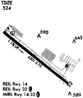
Runways
Runway Summary
| Runways: | 14/32 |
| Longest Runway: | 14/32 is 4202 ft (1281 m) long |
| Runways with an Instrument Approach: |
GAI Airport Runway Details
| Runway 14/32 | 4202 ft x 75 ft (1281 m x 23 m) | |
| Runway Length Source: | NGS as of 11/08/2003 | |
| Surface: | Asphalt - Good condition - No special surface treatment | |
| Runway Edge Lights: | Medium Intensity | |
Runway 14 |
Runway 32 |
|
Elevation: |
493.3 | 538.7 |
Latitude: |
39-10-18.6369N | 39-09-53.4181N |
Longitude: |
077-10-18.8006W | 077-09-36.4145W |
|
Runway True Alignment: |
127 | 307 |
Glide Path Angle: |
3.0 degrees | 3.2 degrees |
Traffic Pattern: |
Left | Right |
Runway Markings Type: |
Nonprecision Instrument | Nonprecision Instrument |
Runway Markings Condition: |
Good | Good |
Object at End: |
TREES | POLE |
Object Height: |
12 | 26 |
Object Marked/Lighted?: |
Lighted | |
Distance from End: |
242 | 949 |
Object Centerline Offset: |
118 ft. right of centerline | 17 ft. right of centerline |
Visual Glide Slope Indicators: |
4-Box VASI On Left Side Of Runway | 4-Light PAPI On Left Side Of Runway |
REIL: |
Yes | Yes |
Threshold Crossing Height: |
53 | 45 |
Services
Airframe Repair: |
Major |
Powerplant Repair: |
Major |
Fuel Available: |
100LL |
Landing Fees: |
No |
Parking: |
Tiedowns available |
Maps & Diagrams
GAI Sectional
Flight Planning
at skyvector.com
at skyvector.com